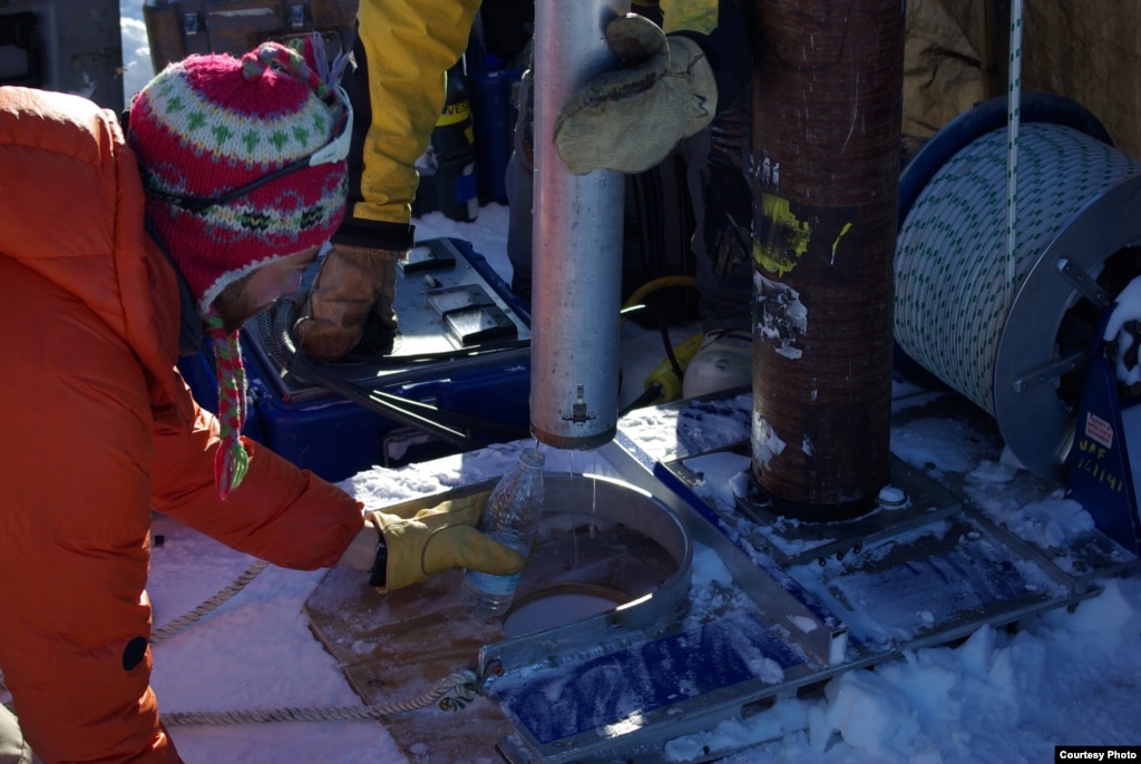
Published on Jan 6, 2014
Pages
- Home
- Biological Hazards / Mass Animal Deaths/Odd Animal Behavior / Diseases
- Disaster Management / Climate Change / Sea-Oceans
- Earth Sciences / Flora and Fauna / Nature / Environmental / Eco-Systems
- Earthquakes / Tsunamis / Seismic Activity
- Epidemic Hazards
- Extreme Weather / Extreme Temperatures / Giant Wave Impact / Drought
- Flooding - Landslides - Mudslides
- Forest / Wild Fires
- Geo-Engineering / Weather Manipulation / Earth's Atmosphere
- Geologic Event / Sinkholes / Discoveries
- Hazmat / Environmental Pollution / Gas Leaks / Explosions
- Nuclear Power Truths / Nuclear Events / Radiation
- Solar Activity
- Space / Solar System / Astrophotography / Discoveries
- Storms / Tornadoes
- Technological Disasters / Power Outage / Mysterious Phenomena
- Volcanic Events / Discoveries
- Family Survival Protocol - Affiliate Sites
Showing posts with label University of Utah. Show all posts
Tuesday, January 7, 2014
Tuesday, December 24, 2013
Massive Lake Found Under Greenland Ice
Water
from the Greenland perennial firn aquifer draining from a core
extracted 12 m below the surface of the ice sheet. The core was drilled
in April, months prior to seasonal melt, with air temperatures -15 C
confirming the water was retained at depth th
Researchers at the University of Utah say the lake, known as a “perennial firn aquifer,” remains liquid year-round despite the otherwise perpetually frozen landscape.
“Large amounts of snow fall on the surface late in the summer and quickly insulates the water from the subfreezing air temperatures above, allowing the water to persist all year long,” said Rick Forster, lead author and professor of geography at the University of Utah.
The Greenland Ice Sheet is vast, covering roughly the same area as the states of California, Nevada, Arizona, New Mexico, Colorado and Utah combined. The average thickness of the ice is 5,000 feet. In 2012, the ice sheet lost volume of 60 cubic miles – a record for melt and runoff.
Read More Here
.....
A drill rig was used to extract old snow (firn) cores from within the Greenland snow aquifer. Credit: Evan Burgess
Big surprises still hide beneath the frozen surface of snowy Greenland. Despite decades of poking and prodding by scientists, only now has the massive ice island revealed a hidden aquifer.
In southeast Greenland, more than 100 billion tons of liquid water soaks a slushy snow layer buried anywhere from 15 to 160 feet (5 to 50 meters) below the surface. This snow aquifer covers more than 27,000 square miles (70,000 square kilometers) — an area bigger than West Virginia — researchers report today (Dec. 22) in the journal Nature Geoscience.
"We thought we had an understanding of how things work in Greenland, but here is this entire storage system of water we didn't realize was there," said Richard Forster, lead study author and a glaciologist at the University of Utah.
The discovery will help scientists better understand the fate of Greenland's annual surface melt, which contributes to sea level rise. When the summer sun warms the Arctic island, a giant water world of stunning blue lakes and streams appears atop the ice. Tracking this surface runoff helps scientists account for ice lost to melting each year. Until now, researchers thought most of this water went to the ocean or refroze on the ice. Now they've found a new hiding place.
"This throws an additional complexity into the system," Forster told LiveScience.
There is enough water in the snow aquifer to raise global sea level by 0.015 inches (0.4 millimeters), according to a separate study by the same team published Nov. 30 in the journal Geophysical Research Letters (GRL). Every year, Greenland adds 0.03 inches (0.7 mm) of water to global sea level rise from melting snow and ice, Forster said. [Top 10 Surprising Results of Global Warming]
Where water flows
No one yet knows how old the water in the aquifer is, and whether it stays trapped in the snow or reaches the ocean in slow streams or catastrophic floods. However, the top of the water table rose after Greenland's huge surface melt in 2012, the researchers report in their GRL study.

The final destination of Greenland's melt water is also key to understanding how the ice sheet ebbs and flows, because water under the ice sheet lubricates flowing glaciers. Researchers know some melt water goes to the bottom of the ice, trickling through cracks and racing through vertical pipes called moulins. Some of the water also simply refreezes on the surface when winter comes. Liquid water sitting in buried snow layers can also slowly warm and melt the ice sheet.
"The existence of this rather flavorless natural snow cone has many implications for the future of the ice sheet, some that may make the ice go away faster and others that help keep the ice a little longer," said Richard Alley, a glaciologist at Pennsylvania State University, who was not involved in the study. "We would like to understand these implications better so we can help reduce the uncertainties about future changes."
Read More Here
.....
December 23, 2013
A
massive lake has been found under the ice in Greenland. The 43,500
square kilometer body of water could have major implications for
understanding sea level rise.Researchers at the University of Utah say the lake, known as a “perennial firn aquifer,” remains liquid year-round despite the otherwise perpetually frozen landscape.
“Large amounts of snow fall on the surface late in the summer and quickly insulates the water from the subfreezing air temperatures above, allowing the water to persist all year long,” said Rick Forster, lead author and professor of geography at the University of Utah.
The Greenland Ice Sheet is vast, covering roughly the same area as the states of California, Nevada, Arizona, New Mexico, Colorado and Utah combined. The average thickness of the ice is 5,000 feet. In 2012, the ice sheet lost volume of 60 cubic miles – a record for melt and runoff.
Read More Here
.....
Greenland's Snow Hides 100 Billion Tons of Water
By Becky Oskin, Staff Writer | December 22, 2013 01:00pm ET
A drill rig was used to extract old snow (firn) cores from within the Greenland snow aquifer. Credit: Evan Burgess
Big surprises still hide beneath the frozen surface of snowy Greenland. Despite decades of poking and prodding by scientists, only now has the massive ice island revealed a hidden aquifer.
In southeast Greenland, more than 100 billion tons of liquid water soaks a slushy snow layer buried anywhere from 15 to 160 feet (5 to 50 meters) below the surface. This snow aquifer covers more than 27,000 square miles (70,000 square kilometers) — an area bigger than West Virginia — researchers report today (Dec. 22) in the journal Nature Geoscience.
"We thought we had an understanding of how things work in Greenland, but here is this entire storage system of water we didn't realize was there," said Richard Forster, lead study author and a glaciologist at the University of Utah.
The discovery will help scientists better understand the fate of Greenland's annual surface melt, which contributes to sea level rise. When the summer sun warms the Arctic island, a giant water world of stunning blue lakes and streams appears atop the ice. Tracking this surface runoff helps scientists account for ice lost to melting each year. Until now, researchers thought most of this water went to the ocean or refroze on the ice. Now they've found a new hiding place.
"This throws an additional complexity into the system," Forster told LiveScience.
There is enough water in the snow aquifer to raise global sea level by 0.015 inches (0.4 millimeters), according to a separate study by the same team published Nov. 30 in the journal Geophysical Research Letters (GRL). Every year, Greenland adds 0.03 inches (0.7 mm) of water to global sea level rise from melting snow and ice, Forster said. [Top 10 Surprising Results of Global Warming]
Where water flows
No one yet knows how old the water in the aquifer is, and whether it stays trapped in the snow or reaches the ocean in slow streams or catastrophic floods. However, the top of the water table rose after Greenland's huge surface melt in 2012, the researchers report in their GRL study.

Water from the Greenland snow aquifer draining from a drill core
extracted 40 feet (12 meters) below the surface of the ice sheet in
April, before the summer surface melt, with air temperatures of 5
degrees Fahrenheit (minus 15 degrees Celsius).
Credit: Ludovic Brucker
The
group will return to southeast Greenland in the coming years to answer
these and other questions, Forster said. "Just seeing how old it is
would answer a lot of questions," he said.Credit: Ludovic Brucker
The final destination of Greenland's melt water is also key to understanding how the ice sheet ebbs and flows, because water under the ice sheet lubricates flowing glaciers. Researchers know some melt water goes to the bottom of the ice, trickling through cracks and racing through vertical pipes called moulins. Some of the water also simply refreezes on the surface when winter comes. Liquid water sitting in buried snow layers can also slowly warm and melt the ice sheet.
"The existence of this rather flavorless natural snow cone has many implications for the future of the ice sheet, some that may make the ice go away faster and others that help keep the ice a little longer," said Richard Alley, a glaciologist at Pennsylvania State University, who was not involved in the study. "We would like to understand these implications better so we can help reduce the uncertainties about future changes."
Read More Here
.....
Related articles
New aquifer in Greenland ice sheet discovered - Business Standard
Massive Lake Found Under Greenland Ice
Greenland's Snow Hides 100 Billion Tons of Water
Enormous Aquifer Discovered Under Greenland Ice Sheet
Enormous aquifer discovered under Greenland ice sheet
Melt water reservoir lurks under ice
Greenland Snow Aquifer Hides 100 Billion Tons Of Water
Massive Liquid Water Reservoir Discovered Under Greenland Ice Sheets
Tuesday, October 29, 2013
Yellowstone Park's Massive Underground Volcano is Bigger Than We Thought
First Posted: Apr 18, 2013 04:07 PM EDT
When volcanoes erupt,
silica-rich magma can burst through the Earth's crust, burning the
surrounding area in a massive explosion. Now, it turns out that this
magma can lurk in Earth's upper crust for hundreds of thousands of years
without triggering an eruption. (Photo : Flickr/Don Graham)
The National Park is home to hot springs, mudpots, fumaroles and geysers, so it's not surprising that it has quite a bit of volcanic activity under the ground. Known as a hotspot, a massive volume of molten magma is located beneath Yellowstone. This plume of superheated rock rises from Earth's mantle, punching through the continent's crust as North America has slowly drifted over it. The phenomenon has left a trail of calderas created by massive volcanic eruptions in its wake; the most recent occurred about 640,000 years ago.
Yellowstone is infamous for its potential for a "super eruption." When the Huckleberry Ridge eruption in Yellowstone occurred about 2 million years ago, it darkened the skies with ash from southern California to the Mississippi River. It was one of the largest eruptions to have occurred on our planet. Understanding the volcanic activity of this location is therefore crucial for predicting future eruptions.
Read More Here
..........
nature.com
Large magma reservoir gets bigger
But earthquakes, not eruptions, are Yellowstone's most serious geological risk.
The reservoir of molten rock underneath Yellowstone National Park in the United States is at least two and a half times larger than previously thought. Despite this, the scientists who came up with this latest estimate say that the highest risk in the iconic park is not a volcanic eruption but a huge earthquake.
Yellowstone is famous for having a ‘hot spot’ of molten rock that rises from deep within the planet, fuelling the park’s geysers and hot springs1. Most of the magma resides in a partially molten blob a few kilometres beneath Earth’s surface.
New pictures of this plumbing system show that the reservoir is about 80 kilometres long and 20 kilometres wide, says Robert Smith, a geophysicist at the University of Utah in Salt Lake City. “I don’t know of any other magma body that’s been imaged that’s that big,” he says.
Smith reported the finding on 27 October at the annual meeting of the Geological Society of America in Denver, Colorado.
Yellowstone lies in the western United States, where the mountain states of Wyoming, Montana and Idaho converge. The heart of the park is a caldera — a giant collapsed pit left behind by the last of three huge volcanic eruptions in the past 2.1 million years.
Read More Here
..........
Related articles
Biggest magma reservoir just got bigger
Yellowstone Supervolcano Alert
Yellowstone Supervolcano Alert: The Most Dangerous Volcano In America Is Roaring To Life
Yellowstone Supervolcano Alert
Tuesday, September 24, 2013
Earthquake 3.6 Magnitude - State of Wyoming, [Yellowstone National Park, near the Old Faithful geyser] : UPDATE 9/23/2013
Earth Watch Report - Earthquakes

Image Source : Wikimedia . Org
Yellowstone National park
http://de.wikipedia.org/wiki/Bild:Yellowstone_Nationalpark.jpg by Huebi
...
| Earthquake | USA | State of Wyoming, [Yellowstone National Park, near the Old Faithful geyser] |
| Description | |
| A small earthquake struck in Yellowstone National Park near the Old Faithful geyser on Sunday, but even the seismic shaking could not stop the trusty waterspout. The U.S. Geological Survey said that a 3.6 magnitude earthquake struck at Yellowstone, centered close to six miles away from the geyser Old Faithful. The quake was part of a series of more than 100 tremors in the park since last Tuesday. While Sunday’s was the strongest, a number of other earthquakes have been felt by Yellowstone visitors. “A total of 130 earthquakes of magnitude 0.6 to 3.6 have occurred in these three areas, however, most have occurred near the Lower Geyser Basin,” park officials noted. “Notably, much of the seismicity in Yellowstone occurs as swarms. The University of Utah Seismograph Stations continues to monitor Yellowstone earthquakes and will provide additional information if the earthquake swarm activity increases.” The park has been in the news a bit this summer. In June a norovirus outbreak infected at least 100 visitors, leading to allegations that visitors were not being properly warned of the outbreak. “Hundreds of signs in Yellowstone warn motorists to not harm wild animals, but not a single sign warning human beings of a huge outbreak of the norovirus is present,” park visitor Louis Greenwald told The Inquisitr. The Yellowstone earthquake did not seem too much an inconvenience to the park’s visitors. A live video feed the National Park Service has set up to show Old Faithful showed several hundred of onlookers watching it erupt later in the day. |
Back
| Updated: | Monday, 23 September, 2013 at 03:34 UTC |
| Description | |
| It was recently reported that a very rare triple swarm of earthquakes rocked Yellowstone National Park. In fact, Bob Smith, a geophysics professor out of the University of Utah, says he has never seen even two swarms occur together before in all the 53 years that he has been monitoring seismic activity. Now, he he's seen three. An earthquake swarm, seismologists say, is an event where a sequence of earthquakes occurs in a limited geographic area over a short period of time. Speaking about the event, Smith called it "remarkable," asking, "How does one swarm relate to another? Can one swarm trigger another and vice versa?" No answers are available to Smith's questions, however, because simultaneous swarms haven't been detected before. Smith says he believes that at least two of the swarms are probably related to each other though. The three swarms hit in the following areas: Lewis Lake, the Lower Geyser Basin and the northwest part of Norris Geyser Basin.Earlier this month, on September 15, the largest earthquake to rock Yellowstone in over a year occurred about six miles north of the Old Faithful Geyser. Its magnitude was about 3.6 at its epicenter. It takes a magnitude of about 3.0 for people to feel it, a Yellowstone representative named Al Nash told the Jackson Hole News and Guide. The recent swarms of earthquakes began on September 10 and finished up on September 16. The University of Utah put out a statement saying that altogether 130 earthquakes with magnitudes ranging from 0.6 to 3.6 occurred in the area, with most of them being located in the Lower Geyser Basin. But, including many smaller events which were not detected, there were many more quakes than this. The recent swarms produced four earthquakes which, although they were not large, were significant enough in size to be felt. The first, which had a magnitude of 3.5, happened on September 13, about 17 miles northeast of West Yellowstone, Montana. The next two tremblors to be felt occurred early on the morning of September 15 with magnitudes of 3.2 and 3.4 respectively. These two occurred in rapid succession, with one being detected at 5:10 AM and the other at 5:11 AM. The quakes happened about 15 miles southeast of West Yellowstone. The largest earthquake recording during the swarm, a 3.6, was measured nearby about 4 1/2 hours later.According to Nash, a strong enough earthquake, like the 7.3-7.5 quake that shook the Hebgen Lake area in 1959, has the potential to change the activity of the geysers in the area. And, in fact the 1959 quake did. It caused nearly 300 features to erupt, included 160 where there were no previous records of geysers. None of the current earthquakes were powerful enough to create these types of changes, however. Smith says he believes that the current swarms of earthquakes may, in fact, be related to the 1959 earthquake. "We think that much of the seismicity is still aftershocks from that event in 1959. It can go on for hundreds of years." Usually only about half a dozen earthquakes occur each year in Yellowstone, Smith noted, so it is quite unusual for this level of swarm activity to rock the park. | |
The Billings Gazette
Swarm of earthquakes shake Yellowstone
September 22, 2013 9:22 am • Associated Press
Now, Smith, a University of Utah geophysics professor, has seen three swarms at once.
“It’s very remarkable,” Smith said. “How does one swarm relate to another? Can one swarm trigger another and vice versa?”
Because concurrent swarms have never been detected in the past, the answers aren’t in yet, Smith said. The geophysicist said he “wouldn’t doubt” if at least two of the events were related.
Temblors from the three quake swarms mostly hit in three areas: Lewis Lake, the Lower Geyser Basin and the northwest part of Norris Geyser Basin.
The largest earthquake shook the ground near Old Faithful Geyser on Sept. 15.
The epicenter of the magnitude 3.6 quake, the largest in Yellowstone in about a year, was just 6 miles to the north of Old Faithful.
Related articles
Swarm of earthquakes shake Yellowstone National Park
TICKING TIME BOMB? Triple swarm of earthquakes shakes Yellowstone
Triple swarm of earthquakes shakes Yellowstone
Yellowstone Earthquake Sept 16
Swarm of earthquakes shake Yellowstone
Subscribe to:
Posts (Atom)


