Showing posts with label National Science Foundation. Show all posts

Sunday, May 4, 2014

National Science Foundation : Viruses wage war on deep-sea bacteria to essentially feed and propagate

 ScienceDaily: Your source for the latest research news


Undersea warfare: Viruses hijack deep-sea bacteria at hydrothermal vents

Date:
May 1, 2014
Source:
National Science Foundation
Summary:
More than a mile beneath the ocean's surface, as dark clouds of mineral-rich water billow from seafloor hot springs called hydrothermal vents, unseen armies of viruses and bacteria wage war.
.....

Credit: NOAA
[Click to enlarge image]

More than a mile beneath the ocean's surface, as dark clouds of mineral-rich water billow from seafloor hot springs called hydrothermal vents, unseen armies of viruses and bacteria wage war.
Like pirates boarding a treasure-laden ship, the viruses infect bacterial cells to get the loot: tiny globules of elemental sulfur stored inside the bacterial cells.
Instead of absconding with their prize, the viruses force the bacteria to burn their valuable sulfur reserves, then use the unleashed energy to replicate.
"Our findings suggest that viruses in the dark oceans indirectly access vast energy sources in the form of elemental sulfur," said University of Michigan marine microbiologist and oceanographer Gregory Dick, whose team collected DNA from deep-sea microbes in seawater samples from hydrothermal vents in the Western Pacific Ocean and the Gulf of California.
"We suspect that these viruses are essentially hijacking bacterial cells and getting them to consume elemental sulfur so the viruses can propagate themselves," said Karthik Anantharaman of the University of Michigan, first author of a paper on the findings published this week in the journal Science Express.
Similar microbial interactions have been observed in shallow ocean waters between photosynthetic bacteria and the viruses that prey upon them.
But this is the first time such a relationship has been seen in a chemosynthetic system, one in which the microbes rely solely on inorganic compounds, rather than sunlight, as their energy source.
"Viruses play a cardinal role in biogeochemical processes in ocean shallows," said David Garrison, a program director in the National Science Foundation's (NSF) Division of Ocean Sciences, which funded the research. "They may have similar importance in deep-sea thermal vent environments."

Read More Here
Enhanced by Zemanta

Wednesday, March 19, 2014

Nasa-funded study: industrial civilisation headed for 'irreversible collapse'?


Friday 14 March 2014 14.28 EDT

Natural and social scientists develop new model of how 'perfect storm' of crises could unravel global system
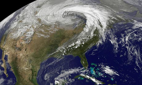
This NASA Earth Observatory released on
This Nasa Earth Observatory image shows a storm system circling around an area of extreme low pressure in 2010, which many scientists attribute to climate change. Photograph: AFP/Getty Images
A new study sponsored by Nasa's Goddard Space Flight Center has highlighted the prospect that global industrial civilisation could collapse in coming decades due to unsustainable resource exploitation and increasingly unequal wealth distribution.
Noting that warnings of 'collapse' are often seen to be fringe or controversial, the study attempts to make sense of compelling historical data showing that "the process of rise-and-collapse is actually a recurrent cycle found throughout history." Cases of severe civilisational disruption due to "precipitous collapse - often lasting centuries - have been quite common."
The research project is based on a new cross-disciplinary 'Human And Nature DYnamical' (HANDY) model, led by applied mathematician Safa Motesharri of the US National Science Foundation-supported National Socio-Environmental Synthesis Center, in association with a team of natural and social scientists. The study based on the HANDY model has been accepted for publication in the peer-reviewed Elsevier journal, Ecological Economics.
It finds that according to the historical record even advanced, complex civilisations are susceptible to collapse, raising questions about the sustainability of modern civilisation:
"The fall of the Roman Empire, and the equally (if not more) advanced Han, Mauryan, and Gupta Empires, as well as so many advanced Mesopotamian Empires, are all testimony to the fact that advanced, sophisticated, complex, and creative civilizations can be both fragile and impermanent."
By investigating the human-nature dynamics of these past cases of collapse, the project identifies the most salient interrelated factors which explain civilisational decline, and which may help determine the risk of collapse today: namely, Population, Climate, Water, Agriculture, and Energy.
These factors can lead to collapse when they converge to generate two crucial social features: "the stretching of resources due to the strain placed on the ecological carrying capacity"; and "the economic stratification of society into Elites [rich] and Masses (or "Commoners") [poor]" These social phenomena have played "a central role in the character or in the process of the collapse," in all such cases over "the last five thousand years."
Currently, high levels of economic stratification are linked directly to overconsumption of resources, with "Elites" based largely in industrialised countries responsible for both:
"... accumulated surplus is not evenly distributed throughout society, but rather has been controlled by an elite. The mass of the population, while producing the wealth, is only allocated a small portion of it by elites, usually at or just above subsistence levels."
The study challenges those who argue that technology will resolve these challenges by increasing efficiency:
"Technological change can raise the efficiency of resource use, but it also tends to raise both per capita resource consumption and the scale of resource extraction, so that, absent policy effects, the increases in consumption often compensate for the increased efficiency of resource use."
Productivity increases in agriculture and industry over the last two centuries has come from "increased (rather than decreased) resource throughput," despite dramatic efficiency gains over the same period.
Read More Here
Enhanced by Zemanta

Saturday, September 28, 2013

Causes of Pakistan Earthquake & New Island Revealed

LiveScience


Location of the Chaman Fault in Pakistan.
Credit: University of Houston
The powerful earthquake that hit Pakistan on Tuesday (Sept. 24) and killed more than 320 people struck along one of the most hazardous yet poorly studied tectonic plate boundaries in the world.
The magnitude-7.7 earthquake was likely centered on a southern strand of the Chaman Fault, said Shuhab Khan, a geoscientist at the University of Houston. In 1935, an earthquake on the northern Chaman Fault killed more than 30,000 people and destroyed the town of Quetta. It was one of the deadliest quakes ever in Southeast Asia.
Shaking from yesterday's earthquake in Pakistan demolished homes in the Awaran district near the epicenter, according to news reports. The death toll will likely rise as survivors and emergency workers search the debris.

In the hours after the quake, a new island suddenly rose offshore in shallow seas near the town of Gwadar, about 230 miles (380 kilometers) southwest of the epicenter. Geologists with the Pakistan Navy have collected samples from the rocky pile, the Associated Press reported. From pictures and descriptions, many scientists think the mound is a mud volcano, which often erupt after strong earthquakes near the Arabian Sea. A second island has also been reported offshore of Ormara, about 170 miles (280 km) east of Gwadar, Geo News said.
"Other mud volcanoes have been triggered at this distance for similar size earthquakes," Michael Manga, a geophysicist and expert on mud volcanoes at the University of California, Berkeley, told LiveScience's OurAmazingPlanet.
Little known risk
The unexplained island may have focused unusual global attention on the earthquake, which hit in a region that frequently experiences devastating temblors. [Video: Island Appears After Pakistan Earthquake]
But despite the hazards faced by millions living near the Chaman Fault, a combination of geography and politics means the seismic zone remains little studied. The Taliban killed 10 climbers, including an American,  in northern Pakistan in June.
"Its location is in an area that is very difficult to do any traditional field work," Khan told LiveScience's OurAmazingPlanet. "I tried twice to submit proposals to [the National Science Foundation] and I got excellent reviews, but the review panel said I was risking my life to work in that area."
But the National Academy of Sciences felt differently. With their support, Khan and his colleagues in Pakistan and at the University of Cincinnati are now studying the fault's current and past movement. This will help the researchers forecast future earthquake risk.
"This fault has had very little work and no paleoseismology," Khan said. "It is really important."
Complex collision zone
Pakistan's deadly earthquakes owe their birth to the juncture of three colliding tectonic plates: Indian, Eurasian and Arabian. The Indian and Eurasian plates grind past each other along the Chaman Fault, triggering destructive temblors.


Read More Here


*******************************************************************************
People walk on an island.
A magnitude 7.7 earthquake struck a remote part of Pakistan with enough force to create a small island.
Photograph from Gwadar Government/AP
Brian Clark Howard
Published September 25, 2013
On Tuesday, a 7.7-magnitude earthquake struck a remote part of western Pakistan, killing more than 260 people and displacing hundreds of thousands. It also triggered formation of a new island off the coast, which has quickly become a global curiosity.
But scientists say the island won't last long.
"It's a transient feature," said Bill Barnhart, a research geophysicist with the U.S. Geological Survey. "It will probably be gone within a couple of months. It's just a big pile of mud that was on the seafloor that got pushed up."
Indeed, such islands are formed by so-called mud volcanoes, which occur around the world, and Barnhart and other scientists suspect that's what we're seeing off the Pakistani coast.
News organizations have reported that the Pakistani island suddenly appeared near the port of Gwadar after the quake. The island is about 60 to 70 feet (18 to 21 meters) high, up to 300 feet (91 meters) wide, and up to 120 feet (37 meters) long, reports the AFP.
Media reports have located the new island at just a few paces to up to two kilometers off the coast of Pakistan. It is about 250 miles (400 kilometers) from the epicenter of the earthquake.
Map by National Geographic maps.
The island appears to be primarily made out of mud from the seafloor, although photos show rocks as well, Barnhart told National Geographic. He has has been studying images and media accounts of the new island from his lab in Golden, Colorado.
"It brought up a dead octopus, and people have been picking up fish on [the island]," he said.


*******************************************************************************
Enhanced by Zemanta

Saturday, August 17, 2013

Analysis of an ice core taken by the National Science Foundation- (NSF) funded West Antarctic Ice Sheet (WAIS) Divide drilling project reveals that warming in Antarctica began about 22,000 years ago

EcoAlert: Changes in Earth's Orbit Appear to be Key to Antarctic Warming

Antarctica-warming-660
Image Credit:  Adventure Journal

Analysis of an ice core taken by the National Science Foundation- (NSF) funded West Antarctic Ice Sheet (WAIS) Divide drilling project reveals that warming in Antarctica began about 22,000 years ago, a few thousand years earlier than suggested by previous records. This timing shows that West Antarctica did not "wait for a cue" from the Northern Hemisphere to start warming, as scientists had previously supposed.
For more than a century scientists have known that Earth's ice ages are caused by the wobbling of the planet's orbit, which changes its orientation to the sun and affects the amount of sunlight reaching higher latitudes.
The Northern Hemisphere's last ice age ended about 20,000 years ago, and most evidence had indicated that the ice age in the Southern Hemisphere ended about 2,000 years later, suggesting that the South was responding to warming in the North.
But research published online Aug. 14 in the journal Nature shows that Antarctic warming began at least two, and perhaps four, millennia earlier than previously thought.
Most previous evidence for Antarctic climate change had come from ice cores drilled in East Antarctica, the highest and coldest part of the continent. However, a U.S.-led research team studying the West Antarctic core found that warming there was well underway 20,000 years ago.
WAIS Divide is a large-scale and multi-year glaciology project supported by the U.S. Antarctic Program (USAP), which NSF manages. Through USAP, NSF coordinates all U.S. science on the southernmost continent and aboard vessels in the Southern Ocean and provides the necessary logistics to make the science possible.


Read More Here


Enhanced by Zemanta