Showing posts with label Wellington. Show all posts

Friday, December 11, 2015

Biological Hazard - New Zealand, [Wellington, Motueka, Kaikoura and Christchurch] South Island : Measles


..........
..........
Biological Hazard in New Zealand on December 11 2015 01:43 PM (UTC).
 

Base data

EDIS NumberBH-20151211-51213-NZL
Event typeBiological Hazard
Date/TimeDecember 11 2015 01:43 PM (UTC)
Last updateDecember 11 2015 01:46 PM (UTC)
Cause of event 
Damage levelIs not or not known Damage level

Geographic information

ContinentAustralia - New-Zealand
CountryNew Zealand
County / StateSouth Island
AreaWellington, Motueka, Kaikoura and Christchurch
Settlement 
Coordinate41° 7.443,173° 0.059

Number of affected people / Humanities loss

Dead person(s)0
Injured person(s)0
Missing person(s)0
Evacuated person(s)0
Affected person(s)0
Foreign people0

Biohazard information

Biohazard level
Disease, agent nameMeasles
Infected person(s)0
SpeciesHuman
Statussuspected
...........
A measles warning has been issued in several areas after an infected tourist traveled the country. A 28-year-old European man carrying the virus traveled from Wellington, to Motueka, Kaikoura and Christchurch from December 3 to 11. The Canterbury District Health Board now is asking anyone who may have come in contact with him and is now presenting symptoms to call their doctor. He is believed to have contracted the highly-infectious virus while in Australia and is in private accommodation in Christchurch until the end of his infectious period. Canterbury medical officer Alistair Humphrey said it was a particularly risky time for the tourism industry. "Over the next few years there is a heightened risk of measles as a result of the decision by parents in the 1990s not to get their children immunized," he said. Where He Stayed: December 3-5: Comfort Hotel, Cuba Street, Wellington,5 December 5: BlueBridge Ferry,December 5-7: Motueka Holiday Top 10,December 8-10: Lazy Shag Backpackers, Kaikoura,December 11: Travels to residence outside Christchurch
............

news

Sick tourist prompts measles warning


NZ Newswire
Measles is untreatable but easily preventagle through vaccinations© Getty Images Measles is untreatable but easily preventable through vaccinations A measles warning has been issued in several areas after an infected tourist traveled the country.

A 28-year-old European man carrying the virus traveled from Wellington, to Motueka, Kaikoura and Christchurch from December 3 to 11.The Canterbury District Health Board now is asking anyone who may have come in contact with him and is now presenting symptoms to call their doctor.
He is believed to have contracted the highly-infectious virus while in Australia and is in private accommodation in Christchurch until the end of his infectious period.

Read More Here
 
............

Monday, January 20, 2014

New Zealand - 6.2 Magnitude Earthquake - 34km SSE of Palmerston North

Earth Watch Report  -  Earthquake


.....
Earthquake New Zealand Northland, [Near to Castlepoint] Damage level Details

.....

Description
Central New Zealand has been rocked by a strong magnitude 6.3 earthquake that shook buildings in central Wellington. The "severe" quake struck 10km north of Castlepoint in Wairarapa at 3.52pm, GeoNet said. It was felt as a long, rolling quake by many Herald readers which lasted about a minute. The giant eagle hanging from the roof of Wellington airport to promote the Hobbit trilogy has fallen down due to the shake. The Weta Workshop eagles installed at the airport each weigh 2 tonnes, have a wingspan of 15m, and were suspended from the roof by eight cables. Wellington Airport could not be immediately reached to confirm whether anyone was injured or whether both fell down. Inspector Mike Coleman of police central communications said there were reports of damage to houses in Eketahuna, including broken windows, collapsed walls and fallen chimneys. However, there were no reported injuries at this stage. The number of reports of damage remained unknown. "Obviously some houses have been damaged," Mr Coleman said. "Windows have been smashed and crockery has been thrown around the place - the usual sort of movement with earthquakes."

Mr Coleman said there were rocks and debris on roads between Woodville and Taihape due to various slips. The Manawatu Gorge road was down to one lane, while the road between Pahiatua and Palmerston North was closed. Bridges and roads around Eketahuna were being checked, Mr Coleman said. Motorists in the lower North Island were urged to take care. In North Wairarapa crockery broke, fridge doors were flung open spilling food onto kitchen floors and disheartened homeowners described the aftermath as "a bloody mess". In Masterton initial reports showed there was little damage in shops although some crockery had been broken. Fire Service central communications shift manager Mike Wanoa said there were no reports of major damage so far. "We're extremely busy at the present time. We've got no reports of damage. "The earthquake has been reasonably major in the Masterton-Eketahuna area, so we're getting multiple calls to all sorts of things at the moment, but we're right in the middle of it now." Electricity retailer Powershop, which has its headquarters in Masterton, tweeted that it had evacuated its call centre following the earthquake. The company said it would continue responding to email queries as best it could. A police communications spokesman said police had not yet received any quake-related callouts. A spokeswoman for the Earthquake Commission (EQC) said the agency was still gathering information on the quake and the volume of calls received. Tranz Metro said all train services in the Wellington region had been suspended due to the quake.

.....

Nine News

New Zealand shaken by 'severe' earthquake

ninemsn staff
2:16pm January 20, 2014

A 2-tonne eagle with a wingspan of 15m promoting the Hobbit trilogy has fallen from the ceiling of Wellington Airport during the quake. (Facebook/Karamea M Swindells-Wallace)

A strong 6.3-magnitude earthquake has rocked central New Zealand this afternoon.

The "severe" earthquake struck 10km north of Castlepoint in Wairarapa, 160km north-east of Wellington, at a depth of 50km at 1.52pm (AEDT), GeoNet said.
There are reports of damage caused inside buildings by the minute-long quake.
The quake was felt by almost the entire country, as far north as Auckland and as far south as Dunedin, The New Zealand Herald reported.
Fire Service central communications shift manager Mike Wanoa said there had been no reports of major damage but crews were "extremely busy".
Train services have been suspended in Wellington as a result of the quake, which has shaken items off shelves in shops and homes.

Read More Here

.....

Strong quake shakes central New Zealand, causes minor damage


WELLINGTON Fri Aug 16, 2013 6:13am EDT


Food and bottles lie scattered on the floor of a shop after they fell out of a fridge during an earthquake in the town of Seddon in the Marlborough region on New Zealand's south island August 16, 2013. REUTERS-Anthony Phelps
1 of 6. Food and bottles lie scattered on the floor of a shop after they fell out of a fridge during an earthquake in the town of Seddon in the Marlborough region on New Zealand's south island August 16, 2013.
Credit: Reuters/Anthony Phelps


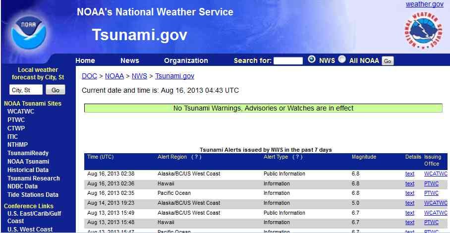
(Reuters) - A magnitude 6.5 earthquake struck south of New Zealand's capital on Friday, sending panicked Wellington workers and residents into the streets, but caused little major damage just weeks after a similar size quake shook the harbourside city.
The quake, which hit near the northern tip of New Zealand's South Island, was dangerously shallow at a depth of about 8 km (5 miles), similar to a deadly tremor that shattered the south island city of Christchurch in 2011.
"The building just shook and it went on and on and on. There's a lot of police out here and fire sirens going off. It's pretty frightening," said Chris Birks, General Manager of the Hotel d'Urville in Blenheim, near the quake epicenter.
Fire authorities said it was too early to assess the impact fully. There were reports of superficial damage to buildings from the quake, which shattered windows and sent items tumbling from supermarket shelves.
The U.S. Geological Survey originally measured the quake with a magnitude of 6.8 but later revised that figure down to 6.5. New Zealand quake monitoring service GNS Science put the magnitude at 6.2.

Read More Here

.....

M 6.2 - 34km SSE of Palmerston North, New Zealand

2014-01-20 02:52:45 UTC


Earthquake location 40.634°S, 175.776°E

Event Time

  1. 2014-01-20 02:52:45 UTC
  2. 2014-01-20 15:52:45 UTC+13:00 at epicenter
  3. 2014-01-19 20:52:45 UTC-06:00 system time

Location

40.634°S 175.776°E depth=28.0km (17.4mi)

Nearby Cities

  1. 34km (21mi) SSE of Palmerston North, New Zealand
  2. 37km (23mi) NNE of Masterton, New Zealand
  3. 42km (26mi) E of Levin, New Zealand
  4. 71km (44mi) ENE of Paraparaumu, New Zealand
  5. 111km (69mi) NE of Wellington, New Zealand
.....

Tectonic Summary

The January 20, 2014 M6.2 earthquake northeast of Masterton in the North Island of New Zealand is located approximately 115 km northeast of Wellington. The earthquake resulted from northeast-southwest oriented normal faulting 175 km to the west of the Hikurangi Trench, where the Pacific plate subducts westward beneath the North Island. At the latitude of this event, the Pacific plate moves towards the west-southwest with respect to the Australia plate at a rate of approximately 42 mm/yr. The faulting character, location and depth of this earthquake indicate it is an intraplate event either within Australia plate crust above the subducting Pacific plate, or within the interior of subducted Pacific slab, rather than a plate boundary event on the subduction zone thrust interface.
New Zealand experiences fairly frequent moderate-sized earthquakes; the region within 200 km of the January 20, 2014 event has experienced 35 earthquakes of M 5.5 or larger over the past century. The 2014 event is just a few kilometers to the east of a M 7.3 earthquake in March of 1934, and approximately 40 km southwest of two M6.2 and 6.4 earthquakes near Dannevirke in March and May of 1990, respectively. The 1990 events did not cause significant damage or fatalities.

Seismotectonics of the Eastern Margin of the Australia Plate

The eastern margin of the Australia plate is one of the most sesimically active areas of the world due to high rates of convergence between the Australia and Pacific plates. In the region of New Zealand, the 3000 km long Australia-Pacific plate boundary extends from south of Macquarie Island to the southern Kermadec Island chain. It includes an oceanic transform (the Macquarie Ridge), two oppositely verging subduction zones (Puysegur and Hikurangi), and a transpressive continental transform, the Alpine Fault through South Island, New Zealand.
Since 1900 there have been 15 M7.5+ earthquakes recorded near New Zealand. Nine of these, and the four largest, occurred along or near the Macquarie Ridge, including the 1989 M8.2 event on the ridge itself, and the 2004 M8.1 event 200 km to the west of the plate boundary, reflecting intraplate deformation. The largest recorded earthquake in New Zealand itself was the 1931 M7.8 Hawke's Bay earthquake, which killed 256 people. The last M7.5+ earthquake along the Alpine Fault was 170 years ago; studies of the faults' strain accumulation suggest that similar events are likely to occur again.
North of New Zealand, the Australia-Pacific boundary stretches east of Tonga and Fiji to 250 km south of Samoa. For 2,200 km the trench is approximately linear, and includes two segments where old (>120 Myr) Pacific oceanic lithosphere rapidly subducts westward (Kermadec and Tonga). At the northern end of the Tonga trench, the boundary curves sharply westward and changes along a 700 km-long segment from trench-normal subduction, to oblique subduction, to a left lateral transform-like structure.
Australia-Pacific convergence rates increase northward from 60 mm/yr at the southern Kermadec trench to 90 mm/yr at the northern Tonga trench; however, significant back arc extension (or equivalently, slab rollback) causes the consumption rate of subducting Pacific lithosphere to be much faster. The spreading rate in the Havre trough, west of the Kermadec trench, increases northward from 8 to 20 mm/yr. The southern tip of this spreading center is propagating into the North Island of New Zealand, rifting it apart. In the southern Lau Basin, west of the Tonga trench, the spreading rate increases northward from 60 to 90 mm/yr, and in the northern Lau Basin, multiple spreading centers result in an extension rate as high as 160 mm/yr. The overall subduction velocity of the Pacific plate is the vector sum of Australia-Pacific velocity and back arc spreading velocity: thus it increases northward along the Kermadec trench from 70 to 100 mm/yr, and along the Tonga trench from 150 to 240 mm/yr.
The Kermadec-Tonga subduction zone generates many large earthquakes on the interface between the descending Pacific and overriding Australia plates, within the two plates themselves and, less frequently, near the outer rise of the Pacific plate east of the trench. Since 1900, 40 M7.5+ earthquakes have been recorded, mostly north of 30°S. However, it is unclear whether any of the few historic M8+ events that have occurred close to the plate boundary were underthrusting events on the plate interface, or were intraplate earthquakes. On September 29, 2009, one of the largest normal fault (outer rise) earthquakes ever recorded (M8.1) occurred south of Samoa, 40 km east of the Tonga trench, generating a tsunami that killed at least 180 people.
Across the North Fiji Basin and to the west of the Vanuatu Islands, the Australia plate again subducts eastwards beneath the Pacific, at the North New Hebrides trench. At the southern end of this trench, east of the Loyalty Islands, the plate boundary curves east into an oceanic transform-like structure analogous to the one north of Tonga.
Australia-Pacific convergence rates increase northward from 80 to 90 mm/yr along the North New Hebrides trench, but the Australia plate consumption rate is increased by extension in the back arc and in the North Fiji Basin. Back arc spreading occurs at a rate of 50 mm/yr along most of the subduction zone, except near ~15°S, where the D'Entrecasteaux ridge intersects the trench and causes localized compression of 50 mm/yr in the back arc. Therefore, the Australia plate subduction velocity ranges from 120 mm/yr at the southern end of the North New Hebrides trench, to 40 mm/yr at the D'Entrecasteaux ridge-trench intersection, to 170 mm/yr at the northern end of the trench.
Large earthquakes are common along the North New Hebrides trench and have mechanisms associated with subduction tectonics, though occasional strike slip earthquakes occur near the subduction of the D'Entrecasteaux ridge. Within the subduction zone 34 M7.5+ earthquakes have been recorded since 1900. On October 7, 2009, a large interplate thrust fault earthquake (M7.6) in the northern North New Hebrides subduction zone was followed 15 minutes later by an even larger interplate event (M7.8) 60 km to the north. It is likely that the first event triggered the second of the so-called earthquake "doublet".
More information on regional seismicity and tectonics

.....

Instrumental Intensity

ShakeMap Intensity Image

.....
Enhanced by Zemanta

Friday, August 16, 2013

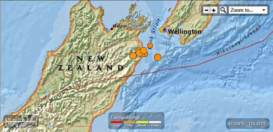
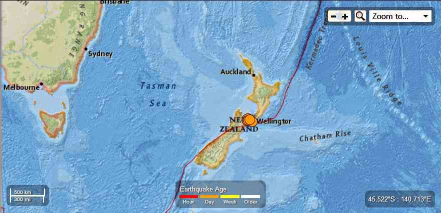
New Zealand - 6.5 Magnitude Earthquake 22km S of Blenheim followed by 7 aftershocks ranging from 5.5 to 4.7 Magnitude August 16th , 2013

Earth Watch Report  -  Earthquakes


 photo NewZealand-65MagEQwith7aftershocksAugust16th20132_zps834294d4.jpg

 photo NewZealand-65MagEQwith7aftershocksAugust16th2013_zpsf63e7f36.jpg
...

M6.5 - 22km S of Blenheim, New Zealand

2013-08-16 02:31:08 UTC


Earthquake location 41.715°S, 173.976°E

Event Time

  1. 2013-08-16 02:31:08 UTC
  2. 2013-08-16 14:31:08 UTC+12:00 at epicenter
  3. 2013-08-15 21:31:08 UTC-05:00 system time

Location

41.715°S 173.976°E depth=9.9km (6.2mi)

Nearby Cities

  1. 22km (14mi) S of Blenheim, New Zealand
  2. 75km (47mi) SE of Nelson, New Zealand
  3. 78km (48mi) ESE of Richmond, New Zealand
  4. 79km (49mi) SW of Karori, New Zealand
  5. 81km (50mi) SW of Wellington, New Zealand
...

Instrumental Intensity

ShakeMap Intensity Image
...
 photo NewZealand-65MagEQAugust16th2013_zps4d5452b3.jpg
...

M5.7 - 38km SSE of Blenheim, New Zealand

2013-08-16 02:45:26 UTC

Earthquake location 41.820°S, 174.180°E

Event Time

  1. 2013-08-16 02:45:26 UTC
  2. 2013-08-16 14:45:26 UTC+12:00 at epicenter
  3. 2013-08-15 21:45:26 UTC-05:00 system time

Location

41.820°S 174.180°E depth=5.0km (3.1mi)

Nearby Cities

  1. 38km (24mi) SSE of Blenheim, New Zealand
  2. 75km (47mi) SW of Karori, New Zealand
  3. 77km (48mi) SW of Wellington, New Zealand
  4. 90km (56mi) SW of Lower Hutt, New Zealand
  5. 94km (58mi) SW of Porirua, New Zealand
...

Instrumental Intensity

ShakeMap Intensity Image
...

M5.7 - 38km SSE of Blenheim, New Zealand

2013-08-16 02:45:26 UTC

Earthquake location 41.820°S, 174.180°E

Event Time

  1. 2013-08-16 02:45:26 UTC
  2. 2013-08-16 14:45:26 UTC+12:00 at epicenter
  3. 2013-08-15 21:45:26 UTC-05:00 system time

Location

41.820°S 174.180°E depth=5.0km (3.1mi)

Nearby Cities

  1. 38km (24mi) SSE of Blenheim, New Zealand
  2. 75km (47mi) SW of Karori, New Zealand
  3. 77km (48mi) SW of Wellington, New Zealand
  4. 90km (56mi) SW of Lower Hutt, New Zealand
  5. 94km (58mi) SW of Porirua, New Zealand
...

M5.2 - 63km SSW of Brooklyn, New Zealand

2013-08-16 02:56:25 UTC

Earthquake location 41.870°S, 174.570°E

Event Time

  1. 2013-08-16 02:56:25 UTC
  2. 2013-08-16 14:56:25 UTC+12:00 at epicenter
  3. 2013-08-15 21:56:25 UTC-05:00 system time

Location

41.870°S 174.570°E depth=5.0km (3.1mi)

Nearby Cities

  1. 63km (39mi) SSW of Brooklyn, New Zealand
  2. 64km (40mi) SE of Blenheim, New Zealand
  3. 66km (41mi) SSW of Karori, New Zealand
  4. 67km (42mi) SSW of Wellington, New Zealand
  5. 78km (48mi) SSW of Lower Hutt, New Zealand
...

M5.4 - 32km S of Blenheim, New Zealand

2013-08-16 03:09:10 UTC

Earthquake location 41.806°S, 173.926°E

Event Time

  1. 2013-08-16 03:09:10 UTC
  2. 2013-08-16 15:09:10 UTC+12:00 at epicenter
  3. 2013-08-15 22:09:10 UTC-05:00 system time

Location

41.806°S 173.926°E depth=10.1km (6.3mi)

Nearby Cities

  1. 32km (20mi) S of Blenheim, New Zealand
  2. 79km (49mi) SE of Nelson, New Zealand
  3. 81km (50mi) SE of Richmond, New Zealand
  4. 89km (55mi) SW of Karori, New Zealand
  5. 91km (57mi) SW of Wellington, New Zealand
...

M5.0 - 30km SSE of Blenheim, New Zealand

 2013-08-16 03:21:31 UTC

Earthquake location 41.780°S, 174.060°E

Event Time

  1. 2013-08-16 03:21:31 UTC
  2. 2013-08-16 15:21:31 UTC+12:00 at epicenter
  3. 2013-08-15 22:21:31 UTC-05:00 system time

Location

41.780°S 174.060°E depth=17.0km (10.6mi)

Nearby Cities

  1. 30km (19mi) SSE of Blenheim, New Zealand
  2. 78km (48mi) SW of Karori, New Zealand
  3. 81km (50mi) SW of Wellington, New Zealand
  4. 85km (53mi) SE of Nelson, New Zealand
  5. 88km (55mi) SE of Richmond, New Zealand
...

M4.7 - 36km ESE of Blenheim, New Zealand

2013-08-16 03:26:50 UTC

Earthquake location 41.630°S, 174.360°E

Event Time

  1. 2013-08-16 03:26:50 UTC
  2. 2013-08-16 15:26:50 UTC+12:00 at epicenter
  3. 2013-08-15 22:26:50 UTC-05:00 system time

Location

41.630°S 174.360°E depth=21.0km (13.0mi)

Nearby Cities

  1. 36km (22mi) ESE of Blenheim, New Zealand
  2. 49km (30mi) SW of Karori, New Zealand
  3. 51km (32mi) SW of Wellington, New Zealand
  4. 65km (40mi) SW of Lower Hutt, New Zealand
  5. 68km (42mi) SW of Porirua, New Zealand
...

M5.5 - 30km SE of Blenheim, New Zealand

2013-08-16 03:51:35 UTC

Earthquake location 41.734°S, 174.182°E

Event Time

  1. 2013-08-16 03:51:35 UTC
  2. 2013-08-16 15:51:35 UTC+12:00 at epicenter
  3. 2013-08-15 22:51:35 UTC-05:00 system time

Location

41.734°S 174.182°E depth=10.1km (6.3mi)

Nearby Cities

  1. 30km (19mi) SE of Blenheim, New Zealand
  2. 68km (42mi) SW of Karori, New Zealand
  3. 70km (43mi) SW of Wellington, New Zealand
  4. 84km (52mi) SW of Lower Hutt, New Zealand
  5. 86km (53mi) SW of Porirua, New Zealand
,,,

Instrumental Intensity

ShakeMap Intensity Image
...

Tectonic Summary

The M 6.5 August 16, 2013 earthquake south of Blenheim, New Zealand, occurred as the result of strike-slip faulting on or near the plate boundary between the Pacific and Australia plates. At the latitude of this event, the Pacific plate moves towards the WSW with respect to Australia at a rate of approximately 41 mm/yr. Preliminary faulting mechanisms for the earthquake suggest it is related to either NE-SW right-lateral strike-slip motion (consistent with plate boundary oriented deformation), or NW-SE left-lateral strike-slip motion.
This region of New Zealand has hosted a number of small-moderate sized earthquakes in recent weeks, including a M 6.5 earthquake approximately 40 km east of the August 16 event in the Cook Straight, on July 21, 2013. The July 21 event was preceded by several M 5.3-5.8 events and was followed by a dozen or more aftershocks between M 4.5-5.0, delineating shallow upper plate structures aligned NE-SW, and some deeper subduction-related activity, mostly offshore of the north coast of New Zealand’s South Island.
In contrast to the earlier events, the August 16 earthquake is on land, near the eastern end of the complex Marlborough Fault System. The event is located approximately 10 km southeast of the Awatere Fault in the vicinity of Lake Grassmere. The Marlborough Fault system is characterized by a series of NE striking right-lateral strike slip faults that have dismembered the northern South Island into a series of crustal blocks that are being transported to the northeast. Although there is no specific mapped surface fault that can be linked to the August 16 event at this time, the NE trending fault plane is similarly oriented to the Awatere and Clarence faults of the Marlborough system. In 1966 a M 5.8 earthquake (interpreted to have occurred offshore to the NE of the August 16 event) was widely felt in this area, causing surface deformation of the main railroad line in the region. That event is interpreted to have occurred on a blind structure sub-parallel to the Awatere fault to its northeast.

Seismotectonics of the Eastern Margin of the Australia Plate

The eastern margin of the Australia plate is one of the most sesimically active areas of the world due to high rates of convergence between the Australia and Pacific plates. In the region of New Zealand, the 3000 km long Australia-Pacific plate boundary extends from south of Macquarie Island to the southern Kermadec Island chain. It includes an oceanic transform (the Macquarie Ridge), two oppositely verging subduction zones (Puysegur and Hikurangi), and a transpressive continental transform, the Alpine Fault through South Island, New Zealand.
Since 1900 there have been 15 M7.5+ earthquakes recorded near New Zealand. Nine of these, and the four largest, occurred along or near the Macquarie Ridge, including the 1989 M8.2 event on the ridge itself, and the 2004 M8.1 event 200 km to the west of the plate boundary, reflecting intraplate deformation. The largest recorded earthquake in New Zealand itself was the 1931 M7.8 Hawke's Bay earthquake, which killed 256 people. The last M7.5+ earthquake along the Alpine Fault was 170 years ago; studies of the faults' strain accumulation suggest that similar events are likely to occur again.
North of New Zealand, the Australia-Pacific boundary stretches east of Tonga and Fiji to 250 km south of Samoa. For 2,200 km the trench is approximately linear, and includes two segments where old (>120 Myr) Pacific oceanic lithosphere rapidly subducts westward (Kermadec and Tonga). At the northern end of the Tonga trench, the boundary curves sharply westward and changes along a 700 km-long segment from trench-normal subduction, to oblique subduction, to a left lateral transform-like structure.
Australia-Pacific convergence rates increase northward from 60 mm/yr at the southern Kermadec trench to 90 mm/yr at the northern Tonga trench; however, significant back arc extension (or equivalently, slab rollback) causes the consumption rate of subducting Pacific lithosphere to be much faster. The spreading rate in the Havre trough, west of the Kermadec trench, increases northward from 8 to 20 mm/yr. The southern tip of this spreading center is propagating into the North Island of New Zealand, rifting it apart. In the southern Lau Basin, west of the Tonga trench, the spreading rate increases northward from 60 to 90 mm/yr, and in the northern Lau Basin, multiple spreading centers result in an extension rate as high as 160 mm/yr. The overall subduction velocity of the Pacific plate is the vector sum of Australia-Pacific velocity and back arc spreading velocity: thus it increases northward along the Kermadec trench from 70 to 100 mm/yr, and along the Tonga trench from 150 to 240 mm/yr.
The Kermadec-Tonga subduction zone generates many large earthquakes on the interface between the descending Pacific and overriding Australia plates, within the two plates themselves and, less frequently, near the outer rise of the Pacific plate east of the trench. Since 1900, 40 M7.5+ earthquakes have been recorded, mostly north of 30°S. However, it is unclear whether any of the few historic M8+ events that have occurred close to the plate boundary were underthrusting events on the plate interface, or were intraplate earthquakes. On September 29, 2009, one of the largest normal fault (outer rise) earthquakes ever recorded (M8.1) occurred south of Samoa, 40 km east of the Tonga trench, generating a tsunami that killed at least 180 people.
Across the North Fiji Basin and to the west of the Vanuatu Islands, the Australia plate again subducts eastwards beneath the Pacific, at the North New Hebrides trench. At the southern end of this trench, east of the Loyalty Islands, the plate boundary curves east into an oceanic transform-like structure analogous to the one north of Tonga.
Australia-Pacific convergence rates increase northward from 80 to 90 mm/yr along the North New Hebrides trench, but the Australia plate consumption rate is increased by extension in the back arc and in the North Fiji Basin. Back arc spreading occurs at a rate of 50 mm/yr along most of the subduction zone, except near ~15°S, where the D'Entrecasteaux ridge intersects the trench and causes localized compression of 50 mm/yr in the back arc. Therefore, the Australia plate subduction velocity ranges from 120 mm/yr at the southern end of the North New Hebrides trench, to 40 mm/yr at the D'Entrecasteaux ridge-trench intersection, to 170 mm/yr at the northern end of the trench.
Large earthquakes are common along the North New Hebrides trench and have mechanisms associated with subduction tectonics, though occasional strike slip earthquakes occur near the subduction of the D'Entrecasteaux ridge. Within the subduction zone 34 M7.5+ earthquakes have been recorded since 1900. On October 7, 2009, a large interplate thrust fault earthquake (M7.6) in the northern North New Hebrides subduction zone was followed 15 minutes later by an even larger interplate event (M7.8) 60 km to the north. It is likely that the first event triggered the second of the so-called earthquake "doublet".
More information on regional seismicity and tectonics
...
Enhanced by Zemanta

Thursday, July 25, 2013

New Zealand : Civil Defence officials say there could be up to 10,000 casualties when the Alpine Fault ruptures - and 1000 could be fatal.


*********************************************************

New Zealand Herald


Dire quake warning for Alpine Fault

By Shelley Robinson
9:40 AM Wednesday Apr 10, 2013

The West Coast would suffer most of those casualties and Christchurch will be relatively unscathed in comparison.
The figures have been revealed by Civil Defence emergency management group leader James Thompson, as Civil Defence, hospitals, police and other emergency services plan for a major exercise to prepare for The Big One.
The Alpine Fault is expected to rupture within 50 years, a one-in-500 year event that will produce a devastating earthquake of a magnitude 8 or more.
Towns and cities throughout the South Island will feel its tremendous power, with those on the West Coast taking most of its brunt.
Settlements and possibly towns are expected to be cut off for long periods because of landslides and wrecked roading and other links.


Read More Here


***********************************************************

IBTimes


By Reissa Su | July 22, 2013 12:17 PM EST
The Wellington earthquake could have brought a lot of damage, but the possibility of bigger aftershocks remains high, according to scientists.
The fault line that caused the earthquakes in Cook Strait has long been known to produce earthquake "swarms" but none have been recorded as devastating, according to historical records.
The Wellington quakes that occurred three times on Friday, July 19, and twice on July 21 and the following aftershocks were due to city's plates moving between the Pacific and Australian tectonic plates. The highest magnitude of an earthquake in Wellington was recorded last night at 6.5.
Dr. Richard Sharpe, Director of Earthquake Engineering at Beca said he did not expect the yesterday's quakes at Wellington will cause damage to buildings. However, Mr. Sharpe said the quakes would prompt the city to conduct engineering checks.
New Zealand is resilient to earthquakes in general. According to Mr. Sharpe, other countries that will experience the same type of earthquakes in Wellington will probably cause very brittle buildings to sustain damage.
Professor of Geophysics at Victoria University Euan Smith said that the interface between the underlying Pacific plates and overlying Australian plates was a critical fault. Mr. Smith said the same fault could potentially cause massive earthquakes.


Read More and  Watch Video Here


Enhanced by Zemanta