Wednesday, September 4, 2013

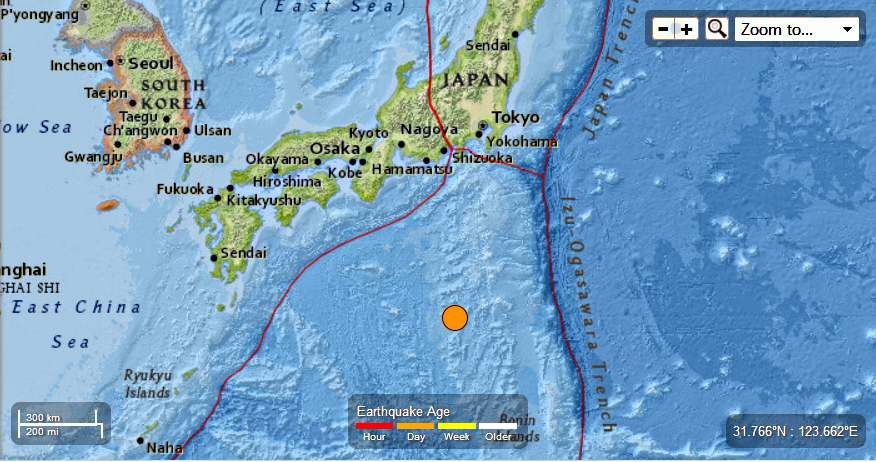
Japan Region - M 6.5 - Izu Islands

Earth Watch Report  -  Earthquakes


 photo Japan-65MagEQSeptember3rd2013_zpsf408d00d.jpg
...
Globe with Earthquake Location

M 6.5 - Izu Islands, Japan region

Preliminary Earthquake Report
Magnitude6.5
Date-Time
  • 4 Sep 2013 00:18:24 UTC
  • 4 Sep 2013 09:18:24 near epicenter
  • 3 Sep 2013 18:18:24 standard time in your timezone
Location29.986N 138.811E
Depth404 km
Distances
  • 356 km (220 mi) SSW of Hachijo-jima, Japan
  • 494 km (306 mi) SSE of Shingu, Japan
  • 514 km (318 mi) S of Oyama, Japan
  • 515 km (319 mi) SSE of Owase, Japan
  • 637 km (394 mi) S of Tokyo, Japan
Location UncertaintyHorizontal: 12.1 km; Vertical 9.1 km
ParametersNph = 70; Dmin = 359.5 km; Rmss = 1.29 seconds; Gp = 38°
Version = 6
Event IDus b000jgfc
For updates, maps, and technical information, see: Event Page or USGS Earthquake Hazards Program
National Earthquake Information Center
U.S. Geological Survey
http://earthquake.usgs.gov/regional/neic/
...

Instrumental Intensity

ShakeMap Intensity Image
...

Enhanced by Zemanta

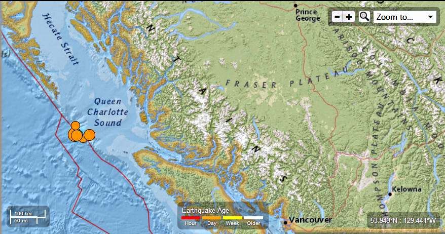
Canada - 6.0 Magnitude Earthquake - 191km WSW of Bella Bella : Total of 6 EQ ranging in Magnitude from 4.2 to 6.0 , September 3rd , 2013

Earth Watch Report  -  Earthquakes


 photo Canada-60MagEQSeptember3rd2013_zps28e6fc50.jpg
...
Globe with Earthquake Location

M 6.0 - 191km WSW of Bella Bella, Canada

Preliminary Earthquake Report
Magnitude6.0
Date-Time
  • 3 Sep 2013 20:19:06 UTC
  • 3 Sep 2013 11:19:06 near epicenter
  • 3 Sep 2013 14:19:06 standard time in your timezone
Location51.198N 130.405W
Depth1 km
Distances
  • 191 km (118 mi) WSW of Bella Bella, Canada
  • 347 km (215 mi) S of Prince Rupert, Canada
  • 388 km (240 mi) WNW of Campbell River, Canada
  • 388 km (240 mi) SSW of Terrace, Canada
  • 592 km (367 mi) NW of Victoria, Canada
Location UncertaintyHorizontal: 14.2 km; Vertical 5.3 km
ParametersNph = 205; Dmin = 193.8 km; Rmss = 1.48 seconds; Gp = 68°
Version = 8
Event IDus b000jg6b
For updates, maps, and technical information, see: Event Page or USGS Earthquake Hazards Program
National Earthquake Information Center
U.S. Geological Survey
http://earthquake.usgs.gov/regional/neic/
...

Instrumental Intensity

ShakeMap Intensity Image
...

Tectonic Summary

The September 3, 2013 earthquake occurred as the result of strike-slip faulting in the boundary region between the Pacific plate,  the North American plate, and the Juan de Fuca plate (or the Explorer subplate of the Juan de Fuca plate).  The epicenter is situated south of Haida Gwaii, also known as the Queen Charlotte Islands, off the west coast of British Columbia.   At the location of this event, the Pacific plate moves approximately north-northwest with respect to the North America plate at a rate of approximately 50 mm/yr. The focal-mechanism of the shock is consistent with right-lateral slip on a fault approximately parallel to the direction of relative motion between the Pacific and North American plates.  The region of the earthquake has complex geologic structure, however, and strike-slip motion on an east-northeast left-lateral fault that is perpendicular  to the trend of the broad-scale plate boundary is also compatible with the focal mechanism and cannot be ruled out.
The region of the September 3, 2013, earthquake has a history of frequent moderate and  large earthquakes.  Since 1973, three other earthquakes of magnitude 6 or greater have occurred within 50 km of the epicenter of the September 3, 2013 shock, the largest of which had magnitude 6.6.  The epicenter of the magnitude 7.8 Haida Gwaii earthquake of October 28, 2012, was situated on the Pacific/North American plate boundary approximately 225 km to the north-northwest.
...
  1. 5.9 163km SW of Bella Bella, Canada 2013-09-03 19:23:12 UTC-05:00 9.9 km

  2. 4.2 179km WSW of Bella Bella, Canada 2013-09-03 18:07:08 UTC-05:00 10.0 km

  3. 5.0 188km SW of Bella Bella, Canada 2013-09-03 17:29:32 UTC-05:00 9.8 km

  4. 4.8 183km SW of Bella Bella, Canada 2013-09-03 16:25:18 UTC-05:00 10.2 km

  5. 4.6 181km SW of Bella Bella, Canada 2013-09-03 16:05:58 UTC-05:00 10.5 km

...
Enhanced by Zemanta

Tuesday, September 3, 2013

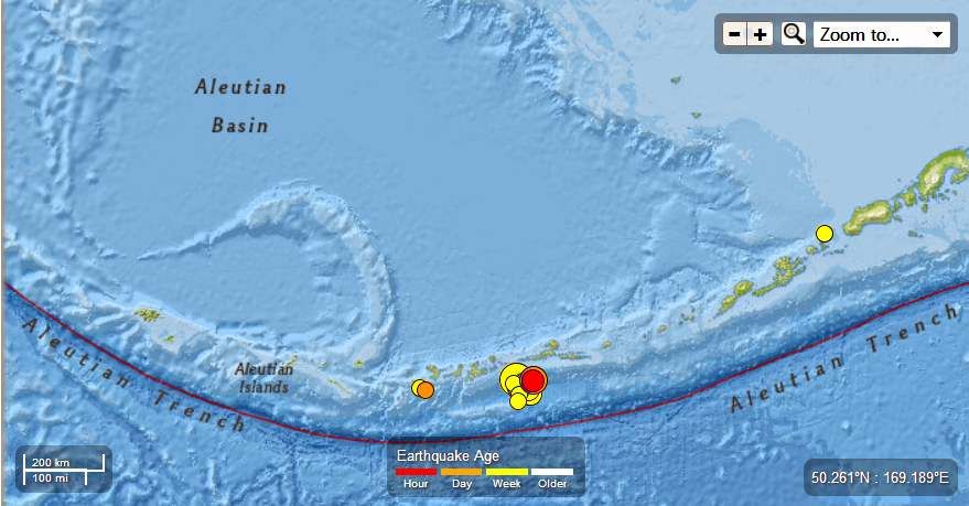
Alaska : 6.5 Magnitude Earthquake - 77km SSW of Atka , September 3rd , 2013 : Total of 31 EQ ranging in Magnitude from 4.5 to 7.0 in the last 7 days.

Earth Watch Report  -  Earthquakes

 photo Alaska-65MagEQSeptember3rd2013_zps06472214.jpg
...

M 6.5 - 77km SSW of Atka, Alaska

Preliminary Earthquake Report
Magnitude 6.5
Date-Time
  • 4 Sep 2013 02:32:33 UTC
  • 3 Sep 2013 14:32:33 near epicenter
  • 3 Sep 2013 20:32:33 standard time in your timezone
Location 51.592N 174.760W
Depth 39 km
Distances
  • 77 km (47 mi) SSW of Atka, Alaska
  • 1532 km (949 mi) SSE of Anadyr', Russia
  • 1809 km (1121 mi) E of Petropavlovsk-Kamchatskiy, Russia
  • 1826 km (1132 mi) E of Yelizovo, Russia
  • 2618 km (1623 mi) W of Whitehorse, Canada
Location Uncertainty Horizontal: 11.3 km; Vertical 9.7 km
Parameters Nph = 105; Dmin = 78.2 km; Rmss = 0.85 seconds; Gp = 58°
Version = A
Event ID us b000jgju
For updates, maps, and technical information, see: Event Page or USGS Earthquake Hazards Program
National Earthquake Information Center
U.S. Geological Survey
http://earthquake.usgs.gov/regional/neic/...

Instrumental Intensity

ShakeMap Intensity Image
...

M 7.0 - 94km ESE of Adak, Alaska

Preliminary Earthquake Report
Magnitude 7.0
Date-Time
  • 30 Aug 2013 16:25:03 UTC
  • 30 Aug 2013 04:25:03 near epicenter
  • 30 Aug 2013 10:25:03 standard time in your timezone
Location 51.711N 175.366W
Depth 34 km
Distances
  • 91 km (56 mi) ESE of Adak, Alaska
  • 1509 km (935 mi) SSE of Anadyr', Russia
  • 1765 km (1094 mi) E of Petropavlovsk-Kamchatskiy, Russia
  • 1782 km (1104 mi) E of Yelizovo, Russia
  • 2642 km (1638 mi) W of Whitehorse, Canada
Location Uncertainty Horizontal: 12.7 km; Vertical 6.3 km
Parameters Nph = 140; Dmin = 93.8 km; Rmss = 1.07 seconds; Gp = 57°
Version = 7
Event ID us b000jdt7
For updates, maps, and technical information, see: Event Page or USGS Earthquake Hazards Program
National Earthquake Information Center
U.S. Geological Survey
http://earthquake.usgs.gov/regional/neic/...

Instrumental Intensity

ShakeMap Intensity Image
...
  1. 5.4 77km SW of Atka, Alaska 2013-09-03 23:16:33 UTC-05:00 44.0 km

  2. 4.5 52km S of Tanaga Volcano, Alaska 2013-09-03 19:43:17 UTC-05:00 49.1 km

  3. 4.9 51km SSW of Tanaga Volcano, Alaska 2013-09-02 17:48:58 UTC-05:00 50.7 km

  4. 4.5 124km SE of Adak, Alaska 2013-09-02 16:07:17 UTC-05:00 24.9 km

  5. 4.7 119km ESE of Adak, Alaska 2013-09-02 10:54:48 UTC-05:00 35.0 km

  6. 4.6 94km ESE of Adak, Alaska 2013-09-02 04:59:03 UTC-05:00 52.5 km

  7. 5.2 100km SW of Atka, Alaska 2013-08-31 14:01:38 UTC-05:00 29.3 km

  8. 4.8 99km SW of Atka, Alaska 2013-08-31 13:59:53 UTC-05:00 39.1 km

  9. 5.2 100km SSW of Atka, Alaska 2013-08-31 05:06:14 UTC-05:00 26.1 km

  10. 5.0 105km SSW of Atka, Alaska 2013-08-31 04:54:13 UTC-05:00 25.1 km

  11. 5.2 97km SW of Atka, Alaska 2013-08-31 04:50:52 UTC-05:00 25.5 km

  12. 5.2 99km SSW of Atka, Alaska 2013-08-31 02:30:27 UTC-05:00 28.6 km

  13. 4.8 102km SSW of Atka, Alaska 2013-08-31 02:04:05 UTC-05:00 32.6 km

  14. 4.5 105km SSW of Atka, Alaska 2013-08-31 01:54:05 UTC-05:00 36.9 km

  15. 5.5 108km ESE of Adak, Alaska 2013-08-31 01:43:55 UTC-05:00 27.6 km

  16. 4.9 113km SSW of Atka, Alaska 2013-08-31 01:43:29 UTC-05:00 10.1 km

  17. 5.9 106km SSW of Atka, Alaska 2013-08-31 01:38:36 UTC-05:00 17.2 km

  18. 4.5 115km SSW of Atka, Alaska 2013-08-31 01:33:14 UTC-05:00 33.8 km

  19. 4.9 93km SW of Atka, Alaska 2013-08-31 01:31:09 UTC-05:00 26.4 km

  20. 4.5 103km SSW of Atka, Alaska 2013-08-31 00:18:37 UTC-05:00 28.8 km

  21. 4.8 97km SW of Atka, Alaska 2013-08-30 20:57:57 UTC-05:00 25.4 km

  22. 5.4 108km ESE of Adak, Alaska 2013-08-30 19:07:28 UTC-05:00 25.5 km

  23. 5.0 96km SW of Atka, Alaska 2013-08-30 16:55:42 UTC-05:00 25.4 km

  24. 4.6 88km SW of Atka, Alaska 2013-08-30 15:47:12 UTC-05:00 32.6 km

  25. 4.6 107km SSW of Atka, Alaska 2013-08-30 15:23:09 UTC-05:00 25.1 km

  26. 4.9 96km SSW of Atka, Alaska 2013-08-30 15:09:32 UTC-05:00 22.4 km

  27. 4.5 98km ESE of Adak, Alaska 2013-08-30 13:52:40 UTC-05:00 24.5 km

  28. 4.7 113km ESE of Adak, Alaska 2013-08-30 11:45:40 UTC-05:00 39.7 km

  29. 4.9 36km NNE of Akutan, Alaska 2013-08-28 19:54:56 UTC-05:00 112.4 km

...

Tectonic Summary

Seismotectonics of Alaska

The Aleutian arc extends approximately 3,000 km from the Gulf of Alaska in the east to the Kamchatka Peninsula in the west. It marks the region where the Pacific plate subducts into the mantle beneath the North America plate. This subduction is responsible for the generation of the Aleutian Islands and the deep offshore Aleutian Trench.
The curvature of the arc results in a westward transition of relative plate motion from trench-normal (i.e., compressional) in the east to trench-parallel (i.e., translational) in the west, accompanied by westward variations in seismic activity, volcanism, and overriding plate composition. The Aleutian arc is generally divided into three regions: the western, central, and eastern Aleutians. Relative to a fixed North America plate, the Pacific plate is moving northwest at a rate that increases from roughly 60 mm/yr at the arc's eastern edge to 76 mm/yr near its western terminus. The eastern Aleutian arc extends from the Alaskan Peninsula in the east to the Fox Islands in the west. Motion along this section of the arc is characterized by arc-perpendicular convergence and Pacific plate subduction beneath thick continental lithosphere. This region exhibits intense volcanic activity and has a history of megathrust earthquakes.
The central Aleutian arc extends from the Andreanof Islands in the east to the Rat Islands in the west. Here, motion is characterized by westward-increasing oblique convergence and Pacific plate subduction beneath thin oceanic lithosphere. Along this portion of the arc, the Wadati-Benioff zone is well defined to depths of approximately 200 km. Despite the obliquity of convergence, active volcanism and megathrust earthquakes are also present along this margin.
The western Aleutians, stretching from the western end of the Rat Islands in the east to the Commander Islands, Russia, in the west, is tectonically different from the central and eastern portions of the arc. The increasing component of transform motion between the Pacific and North America plates is evidenced by diminishing active volcanism; the last active volcano is located on Buldir Island, in the far western portion of the Rat Island chain. Additionally, this portion of the subduction zone has not hosted large earthquakes or megathrust events in recorded history. Instead, the largest earthquakes in this region are generally shallow, predominantly strike-slip events with magnitudes between M5-6. Deeper earthquakes do occur, albeit rather scarcely and with small magnitudes (M<4), down to approximately 50 km.
Most of the seismicity along the Aleutian arc results from thrust faulting that occurs along the interface between the Pacific and North America plates, extending from near the base of the trench to depths of 40 to 60 km. Slip along this interface is responsible for generating devastating earthquakes. Deformation also occurs within the subducting slab in the form of intermediate-depth earthquakes that can reach depths of 250 km. Normal faulting events occur in the outer rise region of the Aleutian arc resulting from the bending of the oceanic Pacific plate as it enters the Aleutian trench. Additionally, deformation of the overriding North America plate generates shallow crustal earthquakes.
The Aleutian arc is a seismically active region, evidenced by the many moderate to large earthquakes occurring each year. Since 1900, this region has hosted twelve large earthquakes (M>7.5) including the May 7, 1986 M8.0 Andreanof Islands, the June 10, 1996 M7.9 Andreanof Islands, and the November 17, 2003 M7.8 Rat Islands earthquakes. Six of these great earthquakes (M8.3 or larger) have occurred along the Aleutian arc that together have ruptured almost the entire shallow megathrust contact. The first of these major earthquakes occurred on August 17, 1906 near the island of Amchitka (M8.3) in the western Aleutian arc. However, unlike the other megathrust earthquakes along the arc, this event is thought to have been an intraplate event occurring in the shallow slab beneath the subduction zone interface.
The first megathrust event along the arc during the 20th century was the November 10, 1938 M8.6 Shumagin Island earthquake. This event ruptured an approximately 300 km long stretch of the arc from the southern end of Kodiak Island to the northern end of the Shumagin Islands and generated a small tsunami that was recorded as far south as Hawaii.
The April 1, 1946 M8.6 Unimak Island earthquake, located in the central Aleutian arc, was characterized by slow rupture followed by a devastating Pacific-wide tsunami that was observed as far south as the shores of Antarctica. Although damage from earthquake shaking was not severe locally, tsunami run-up heights were recorded as high as 42 m on Unimak Island and tsunami waves in Hilo, Hawaii also resulted in casualties. The slow rupture of this event has made it difficult to constrain the focal mechanism and depth of the earthquake, though it is thought to have been an interplate thrust earthquake.
The next megathrust earthquake occurred along the central portion of the Aleutian arc near the Andreanof Islands on March 9, 1957, with a magnitude of M8.6. The rupture length of this event was approximately 1200 km, making it the longest observed aftershock zone of all the historic Aleutian arc events. Although only limited seismic data from this event are still available, significant damage and tsunamis were observed on the islands of Adak and Unimak with tsunami heights of approximately 13 m.
The easternmost megathrust earthquake was the March 28, 1964 M9.2 Prince William Sound earthquake, currently the second largest recorded earthquake in the world. The event had a rupture length of roughly 700 km extending from Prince William Sound in the northeast to the southern end of Kodiak Island in the southwest. Extensive damage was recorded in Kenai, Moose Pass, and Kodiak but significant shaking was felt over a large region of Alaska, parts of western Yukon Territory, and British Columbia, Canada. Property damage was the largest in Anchorage, as a result of both the main shock shaking and the ensuing landslides. This megathrust earthquake also triggered a devastating tsunami that caused damage along the Gulf of Alaska, the West Coast of the United States, and in Hawaii.
The westernmost Aleutians megathrust earthquake followed a year later on February 4, 1965. This M8.7 Rat Islands earthquake was characterized by roughly 600 km of rupture. Although this event is quite large, damage was low owing to the region's remote and sparsely inhabited location. A relatively small tsunami was recorded throughout the Pacific Ocean with run-up heights up to 10.7 m on Shemya Island and flooding on Amchitka Island.
Although the Aleutian arc is highly active, seismicity is rather discontinuous, with two regions that have not experienced a large (M>8.0) earthquake in the past century: the Commander Islands in the western Aleutians and the Shumagin Islands in the east. Due to the dominantly transform motion along the western arc, there is potential that the Commander Islands will rupture in a moderate to large strike-slip earthquake in the future. The Shumagin Islands region may also have high potential for hosting a large rupture in the future, though it has been suggested that little strain is being accumulated along this section of the subduction zone, and thus associated hazards may be reduced.
East of the Aleutian arc along the Gulf of Alaska, crustal earthquakes occur as a result transmitted deformation and stress associated with the northwestward convergence of the Pacific plate that collides a block of oceanic and continental material into the North America plate. In 2002, the Denali Fault ruptured in a sequence of earthquakes that commenced with the October 23 M6.7 Nenana Mountain right-lateral strike-slip earthquake and culminated with the November 3, M7.9 Denali earthquake which started as a thrust earthquake along a then unrecognized fault and continued with a larger right-lateral strike-slip event along the Denali and Totschunda Faults.


More information on regional seismicity and tectonics
...
Enhanced by Zemanta

Planet X Controversy Continues : NZ Astronomer: There is no brown dwarf star ("Planet X") in our solar system


Published on Sep 1, 2013
NZ Astronomer: There is no brown dwarf star ("Planet X") in our solar system

**********************************************

Nemesis Star Theory: The Sun's 'Death Star' Companion

WISE stars, brown dwarfs, nemesis star Nemesis is a theoretical dwarf star thought to be a companion to our sun. The theory was postulated to explain a perceived cycle of mass extinctions in Earth's history. Scientists speculated that such a star could affect the orbit of objects in the far outer solar system, sending them on a collision course with Earth.
Recent astronomical surveys, however, failed to find any evidence that such a star exists.

The argument for Nemesis
In the early 1980s, scientists noticed that extinctions on Earth seemed to fall in a cyclical pattern. Mass extinctions seem to occur more frequently every 27 million years. The long span of time caused them to turn to astronomical events for an explanation.
In 1984, Richard Muller of the University of California Berkley suggested that a red dwarf star 1.5 light-years away could be the cause of the mass extinctions. Later theories have suggested that Nemesis could be a brown or white dwarf, or a low-mass star only a few times as massive as Jupiter. All would cast dim light, making them difficult to spot.
Scientists speculated that Nemesis may affect the Oort cloud, which is made up of icy rocks surrounding the sun beyond the range of Pluto. Many of these chunks travel around the sun in a long-term, elliptical orbit. As they draw closer to the star, their ice begins to melt and stream behind them, making them recognizable as comets.
If Nemesis traveled through the Oort cloud every 27 million years, some argue, it could kick extra comets out of the sphere and send them hurling toward the inner solar system — and Earth. Impact rates would increase, and mass extinctions would be more common.
The Kuiper Belt, a disk of debris that lies inside of the solar system, also has a well-defined outer edge that could be sheared off by a companion star. Researchers have found other systems where a companion star seems to have affected the shape of the debris disks.


Read More Here


**********************************************

Planet X System Observations and Orbital Analysis

Your Own World Books Your Own World Books


Published on Jul 28, 2013
For those of you who've been following and supporting our work at yowusa.com over the years, this is the video you've been waiting for.
In this video, we're going to view some very compelling images of two objects within the Planet X system. The brown dwarf at its core and one of it's outmost orbitals, we call Bluebonnet.
Here is what our findings shows.
Current: PX System is presently inbound from beyond the orbit of Saturn in conjunction with us (opposite side of the sun beyond Earth's orbit.)
Late 2013 to early 2014: The brown dwarf will be in a superior conjunction (opposite side of the sun inside Earth's orbit.) Around this time, the brown dwarf will be passing through the ecliptic into the Northern skies. This is when it will begin have more severe interactions with our Sun. We'll see solar storms and a big increase in volcanism and seismicity.
2015 to 2016: We'll see Bluebonnet (the outermost orbital we've tracked from the Turrialba volcan feed, with hundreds of images.) Shortly after that, the Brown Dwarf will move around to our side of the sun to it's point of perihelion (closest distance to the Sun) to the Greatest-western elongation (our side of the sun, inside our orbit to our right.) At this time, the brown dwarf will enter the kill zone.
Early Kill Zone: The Kill Zone is that part of the brown dwarf's orbit from perihelion to the ecliptic (the plane of our solar system.) This will be when we see solar storms of Biblical proportions.
Late Kill Zone: The Planet X system will exit our system through the Western-quadrature (our side of the side, exiting behind Earth's orbit) as it crosses the ecliptic from the Northern skies into the Southern skies. This is when the pole shift will be most likely as this is when the brown dwarf will lock on to our lithosphere (crust and the portion of the upper mantle) and where it's tidal gravity forces cause the pole shift.
Post Kill Zone: Overall, this whole flyby could take as long as a decade from now to when we begin to see the first signs of blue skies once again.**********************************************


Enhanced by Zemanta

Radiation Levels Spike at Fukushima


Tanks of radiation-contaminated water are seen at the Tokyo Electric Power Co (TEPCO)'s tsunami-crippled Fukushima Daiichi nuclear power plant in Fukushima prefecture, (File photo).Tanks of radiation-contaminated water are seen at the Tokyo Electric Power Co (TEPCO)'s tsunami-crippled Fukushima Daiichi nuclear power plant in Fukushima prefecture, (File photo).


VOA News
Japanese nuclear officials say the radiation level of a tank holding highly contaminated water at Japan's crippled Fukushima nuclear plant has jumped in just one week to a potentially dangerous level.
Tokyo Electric Power Company, or Tepco, said the reading of 1,800 millisieverts at the tank Saturday is enough to kill an exposed person in four hours. On August 22, the same tank measured 100 millisieverts per hour - just a fraction of Saturday's reading.
Tepco also revealed that a pipe connecting two other tanks is leaking. However, the energy company said the water levels of the tanks had not changed. The French news agency says the leak has been patched with plastic tape.
Last month, a tank was found to have leaked 300 tons of highly toxic water.


Read More Here


Related Articles

****************************************************

Fukushima radiation levels 18 times higher than previously thought

TOKYO, JAPAN (BNO NEWS) -- Radiation levels at Japan's crippled Fukushima nuclear plant are 18 times higher than previously thought, the plant's operator said on Sunday, blaming previous readings on inadequate equipment that was not capable of detecting high radiation levels.
The Tokyo Electric Power Company (TEPCO) said it detected radiation of 1,800 millisieverts per hour near the bottom of a storage tank at the Fukushima Daiichi nuclear power, where authorities declared a serious incident last month after highly contaminated water was found leaking from a tank.
"We deeply apologize for the great anxiety and inconvenience caused by the recent contaminated water issues at the Fukushima Daiichi NPS, which affects the residents near the power station and the broader society," a Tepco spokesperson said, emphasizing that not the whole area is engulfed in high levels of radiation.
The company reported radiation of 100 millisieverts per hour on August 22, but experts are now known to have used inadequate equipment that was not capable of detecting higher radiation levels. The new instruments that were used on Saturday were capable of detecting radiation up to 10,000 millisieverts.
Tepco rejected media reports that claimed the higher levels of radiation could kill a person after four hours of exposure. "We believe that simply comparing the 1,800 mSv with those standard levels is not proper, since the standard levels are accumulation of effective dose (not equivalent dose) that express effects for the whole body," the spokesperson said.


Read More Here


****************************************************
Enhanced by Zemanta

Pure Nature Specials : Octopus Volcano

AlliantContent AlliantContent


Published on Feb 26, 2013
Erupting every 20 minutes, Stromboli is one of the world's most active volcanoes. Beneath the surface, a healthy population of common octopus thrives on its treacherous slopes. Discover what allows the octopus to survive in such extreme conditions.
Enhanced by Zemanta