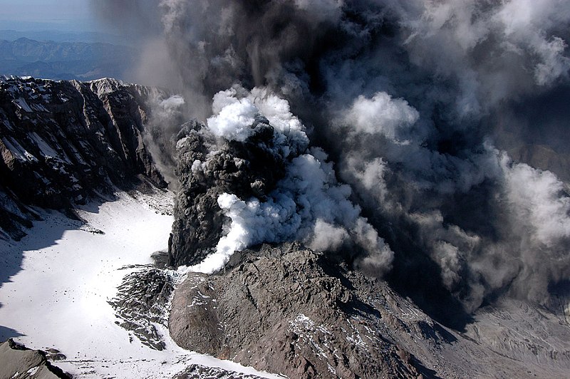
Showing posts with label USGS. Show all posts

Sunday, December 20, 2015

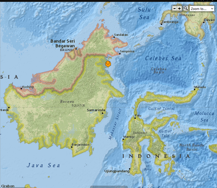
Indonesia - 6.0 Magnitude Earthquake with 4.6 registered not long after , 12/20/2015


 photo Indonesia 6.0 mag EQ 12.20.2015_zpstfcxfd6c.png
Indonesia 6.0 Magnitude EQ 12/20/2015

..........

2 earthquakes in map area

  1. M 4.6 - 38km ESE of Sembakung, Indonesia

    2015-12-20 21:38:39 UTC 10.0 km

  2. M 6.0 - 36km N of Tarakan, Indonesia

    2015-12-20 18:47:35 UTC 9.0 km


..........


...........

NOAA's National Weather Service

Tsunami.gov
Current date and time is: Dec 21, 2015 01:59 UTC
No Tsunami Warnings, Advisories or Watches are in effect
 
 
..........


The Japan Times

Borneo buffeted by strong, shallow M6.0 temblor but no tsunami threat: USGS

AFP-JIJI
 
A strong 6.0 magnitude earthquake struck Indonesia early on Monday, the U.S. Geological Survey (USGS) said, but no immediate damage or casualties were reported.

The quake, which was relatively shallow, struck the northeastern corner of Kalimantan on the Indonesian part of Borneo island, 34 km (21 miles) north of the coastal city of Tarakan, according to the USGS.

The agency reported the quake hitting at a depth of 22 km.

Indonesia’s tsunami warning center said there was no potential for the quake to trigger tsunami. There were also no immediate reports of damage.


Read More Here

...........

Friday, December 18, 2015

Philippines - 5.2 Magnitude earthquake registered near the town of San Juan in Ilocos Sur


5.2-magnitude quake hits Ilocos Sur, aftershocks expected - Phivolcs

51

The earthquake struck near the town of San Juan, Ilocos Sur, the Philippine Institute of Volcanology and Seismology says.

Metro Manila (CNN Philippines) — A 5.2-magnitude earthquake struck near the town of San Juan in Ilocos Sur on Thursday evening (December 17), according to the Philippine Institute of Volcanology and Seismology (Phivolcs).

Aftershocks are expected, it added.

The United States Geological Survey (USGS), however, said the quake that struck at 8:44 p.m. had a magnitude of 5.4.

Strong quake felt in one town

Based on Phivolcs' earthquake intensity scale, an Intensity 5 or a strong quake was reported in the town of Sinait, more than 30 minutes drive from the town of San Juan.


Read More Here

Thursday, December 17, 2015

Mexico - Magnitude 6.6 earthquake registered - 9km ENE of Tres Picos


THE WATCHERS

M6.4 earthquake hits Chiapas, Mexico

 
M6.4 earthquake hits Chiapas, Mexico
A strong earthquake with recorded magnitude of M6.4 (USGS) hit Chiapas, Mexico at 19:49 UTC on December 17, 2015. The agency is reporting a depth of 96.9 km (60.2 miles). EMSC is reporting M6.4 at a depth of 120 km (74.5 miles). 
According to the USGS, the epicenter was located 11 km (7 miles) ENE of Tres Picos, 30 km (19 miles) NW of Pijijiapan, 40 km (25 miles) ESE of Tonala, 62 km (39 miles) SE of Arriaga, Mexico and 342 km (213 miles) WNW of Guatemala City, Guatemala.
There are about 743 880 people living within 100 km (62 miles) radius.


Read More Here
..........

M 6.6 - 9km ENE of Tres Picos, Mexico

............
USGS
...........

 NOAA's National Weather Service

Tsunami.gov

Current date and time is: Dec 18, 2015 03:28 UTC
No Tsunami Warnings, Advisories or Watches are in effect
 
............

Wednesday, December 9, 2015

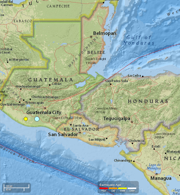
Guatemala - 5.7 Magnitude EQ recorded 12/07/2015. 4.4 Magnitude recorded 12/08/2015


..........
 photo Guatemala 5.7 Mag EQ_zps1pea8ugo.png
USGS
Guatemala   5.7 Magnitude EQ  12/07/2015
..........

2 earthquakes in map area

  1. M 4.4 - 1km NE of Nueva Concepcion, Guatemala

    2015-12-08 13:59:17 UTC 72.0 km

  2. M 5.7 - 1km NNW of Masagua, Guatemala

    2015-12-07 22:53:36 UTC 108.6 km


...........


............

Strong earthquake strikes near Escuintla in Guatemala, southwest of capital city

PUBLISHED Mon, December 07, 2015 - 6:27pm EST

Credit: Google
 
 
A strongly felt earthquake with a preliminary magnitude of 5.7 has struck near the city of Escuintla in south central Guatemala, not far from the capital, seismologists say. (more)

The earthquake, which struck at 4:53 p.m. local time on Monday, was centered next to Masagua about 12 kilometers (7 miles) southwest of Escuintla, or 59 kilometers (37 miles) southwest of Guatemala City. It struck about 108.6 kilometers (67.5 miles) deep, making it a relatively deep earthquake, according to the United States Geological Survey (USGS).


Read More Here


...........


Tuesday, December 1, 2015

Argentina earthquake: Magnitude 5.9 hits Jujuy and Salta near San Salvador. Two additional quakes registered within the next two days at 5.1 and at 4.5


..........

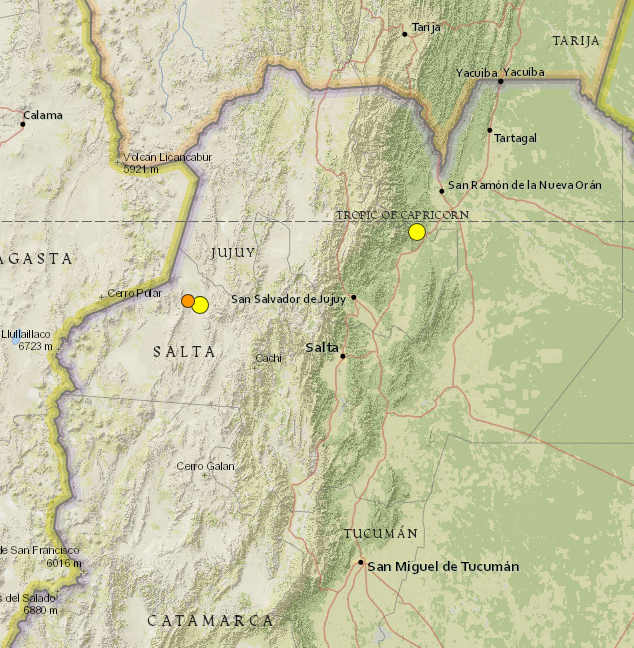
Argentina 5.9 Magnitude EQ 11/29/2015 photo Argentina 5.9 mag EQ_zpst6sagbyf.png
USGS     Argentina 5.9 Magnitude EQ 
..........

3 earthquakes in map area

  1. M 4.5 - 80km W of San Antonio de los Cobres, Argentina

    2015-12-01 07:20:37 UTC 172.4 km

  2. M 5.1 - 67km W of San Antonio de los Cobres, Argentina

    2015-11-30 14:45:22 UTC 158.9 km

  3. M 5.9 - 17km NW of Yuto, Argentina

    2015-11-29 18:52:49 UTC 9.6 km


..........


...........

Argentina earthquake: Tremor hits Jujuy and Salta near San Salvador

PUBLISHED Sun, November 29, 2015 - 2:09pm EST
A strong earthquake with a preliminary magnitude of 5.9 has struck the provinces of Jujuy and Salta in northwest Argentina, near the city of San Salvador de Jujuy, seismologists say. (more)


The earthquake struck at 3:52 p.m. local time and was centered about 9 kilometers west of Yuto, or 91 kilometers northeast of San Salvador de Jujuy. It struck about 10 kilometers deep, making it a shallow earthquake, according to seismologists.

Residents in the region reported feeling the earthquake, but there was no immediate word on damage or casualties.


Read More Here

..........

Thursday, November 19, 2015

Strong undersea earthquake strikes near Solomon Islands. Magnitude 7.0 followed by a 5.1


The Sydney Morning Herald

Date
November 19, 2015 - 7:24AM
Image showing epicentre of Solomon Islands earthquake.

Image showing epicentre of Solomon Islands earthquake. Photo: USGS

A strong undersea earthquake has struck off the coast near the Solomon Islands, according to the Bureau of Meteorology.

The bureau initially reported that an earthquake of 7.1 had occurred at 5.31am ADET, which would be classified as a major earthquake, but the intensity was later reported as 6.8, which is considered strong.


...........................................................................................
 
 
..........
..........
 
Current date and time is: Nov 19, 2015 08:13 UTC
No Tsunami Warnings, Advisories or Watches are in effect
 
..........

11/19/2015 : 8 Earthquakes registered in Lakeview, Oregon ranging in magnitude from 2.5 to 4.2


City Data . com
..........

8 earthquakes

  1. M 3.0 - 70km ESE of Lakeview, Oregon

    2015-11-19 05:50:58 UTC 10.7 km

  2. M 2.8 - 68km ESE of Lakeview, Oregon

    2015-11-19 05:48:48 UTC 11.3 km

  3. M 3.4 - 69km ESE of Lakeview, Oregon

    2015-11-19 05:27:21 UTC 10.8 km

  4. M2.7 - 69km ESE of Lakeview, Oregon

    2015-11-19 02:17:39 UTC 11.0 km


  5. M 2.5 - 69km ESE of Lakeview, Oregon 

    2015-11-19 02:15:32 UTC 10.5 km

  6. M 2.6 - 68km ESE of Lakeview, Oregon

    2015-11-19 02:01:42 UTC 11.4 km

  7. M 4.0 - 69km ESE of Lakeview, Oregon

    2015-11-19 01:50:17 UTC 12.1 km

  8. M 4.2 - 70km ESE of Lakeview, Oregon

    2015-11-19 01:40:02 UTC 12.9 km


..........


..........

..........


Wednesday, November 11, 2015

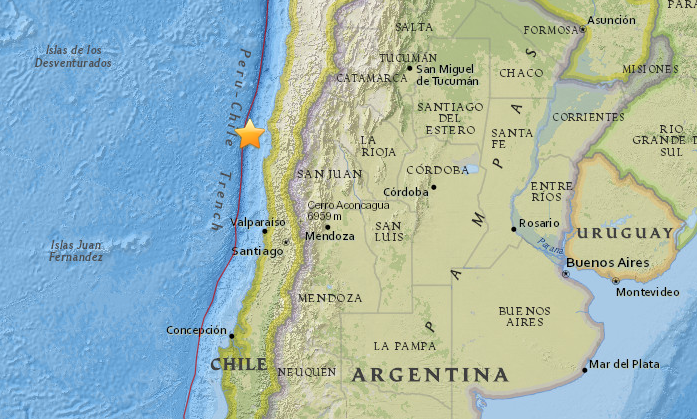
Two Earthquakes - Magnitude 6.9 - 93km NW of Coquimbo, Chile. Total of 13 earthquakes registered ranging in magnitude from 4.0 to 6.9.

.


6.9 quake, powerful aftershocks strike off Chilean coast

 
© earthquake.usgs.gov
A 6.9 magnitude earthquake has struck off the coast of Chile, some 100 kilometers west of Coquimbo, according to USGS. 

The epicenter of the earthquake was located at a depth of just 10 kilometers (6.2 miles), according to the United States Geological Survey, which initially reported it as having a magnitude 6.6.

USGS reports a M6.6 88km NW of Coquimbo, Chile on 11/11/15 @ 1:54:37 UTC http://earthquake.usgs.gov/earthquakes/eventpage/us10003x8t 

13 earthquakes in map area

  1. 5.1 78km NW of Coquimbo, Chile 2015-11-11 03:07:49 UTC 15.2 km
  2. M 6.9 - 98km NW of Coquimbo, Chile

     2015-11-11 02:46:19 UTC 10.0 km

  3. 5.1 83km NW of Coquimbo, Chile 2015-11-11 02:23:38 UTC 10.0 km
  4. 4.9 81km NW of Coquimbo, Chile 2015-11-11 02:18:08 UTC 35.0 km
  5. 4.8 89km NW of Coquimbo, Chile 2015-11-11 02:14:39 UTC 10.0 km
  6. 4.9 76km NW of Coquimbo, Chile 2015-11-11 02:06:36 UTC 10.0 km
  7. M 6.9 - 93km NW of Coquimbo, Chile

    2015-11-11 01:54:37 UTC 10.0 km

  8. 4.4 92km NW of Coquimbo, Chile 2015-11-10 23:48:24 UTC 10.0 km
  9. 4.1 36km SW of Ovalle, Chile 2015-11-10 19:38:22 UTC 50.1 km
  10. 4.0 33km NNE of Calama, Chile 2015-11-10 18:06:20 UTC 111.1 km
  11. 5.7 35km NE of Calama, Chile 2015-11-10 17:48:22 UTC 112.5 km
  12. 4.6 33km SW of Ovalle, Chile 2015-11-10 12:58:37 UTC 37.6 km
  13. 4.4 101km WNW of Coquimbo, Chile 2015-11-10 11:43:46 UTC 10.0 km

..........


..........


..........

NOAA's National Weather Service

Tsunami.gov
 
Current date and time is: Nov 11, 2015 06:32 UTC
No Tsunami Warnings, Advisories or Watches are in effect
 
..........

Saturday, November 7, 2015

Magnitude-6.8 earthquake strikes Chile,Buildings Sway no damage reported


Magnitude-6.8 earthquake strikes Chile, no damage reported

earthquake


SANTIAGO, Chile (AP) — A strong magnitude-6.8 earthquake struck north-central Chile on Saturday, causing buildings to sway in the capital of Santiago, but there were no immediate reports of injuries or damage.

The U.S. Geological Survey said the quake struck at 4:31 a.m. about 29 miles (47 kilometers) southwest of Ovalle, a city 185 miles (300 kilometers) northwest of Santiago, at a depth of 22 miles (36 kilometers).

Chile’s Navy first alerted, but later discounted, the possibility of a small tsunami.
“The situation in the region of the epicenter is now in a state of normality,” Ricardo Toro, the head of Chile’s emergency services, said in a press conference.


Read More Here
...................................................................................................

8 earthquakes in map area

  1. M 4.2 - 26km WSW of Ovalle, Chile

    2015-11-07 23:56:21 UTC 43.8 km

  2. M 4.6 - 98km WNW of Illapel, Chile

    2015-11-07 22:23:54 UTC 17.6 km

  3. M 5.9 - 23km SW of Ovalle, Chile

    2015-11-07 10:53:43 UTC 37.7 km

  4. M 4.7 - 32km SW of Ovalle, Chile

    2015-11-07 10:31:20 UTC 41.3 km

  5. M 4.7 - 33km SW of Ovalle, Chile

    2015-11-07 09:16:59 UTC 35.8 km

  6. M 6.8 - 47km SW of Ovalle, Chile

     2015-11-07 07:31:43 UTC 37.6 km

  7. M 6.2 - 107km WNW of Coquimbo, Chile

    2015-11-07 07:04:31 UTC 12.0 km

  8. M 4.9 - 74km W of Coquimbo, Chile

    2015-11-07 01:34:51 UTC 8.6 km

..........

..........

NOAA's National Weather Service

Tsunami.gov
Current date and time is: Nov 8, 2015 01:16 UTC
No Tsunami Warnings, Advisories or Watches are in effect
 
....................................................................................................

International Business Times

Chile Earthquake Update 2015: Buildings Sway As Magnitude 6.8 Quake Strikes Central Region


By @suman09 s.varandani@ibtimes.com on November 07 2015 5:40 AM EST
 
 
Chile earthquake aftermath
This photo shows local residents walking amid debris left on the beach by the tsunami that ensued after an 8.3 magnitude quake that killed at least 11 people in central Chile. On Saturday, a magnitude 6.8 earthquake hit the same area. Getty Images/Martin Bernetti/AFP
 
A magnitude 6.8 earthquake shook central Chile Saturday with no damage or injuries reported so far. The tremor comes just two months after another quake hit the same area.

Buildings reportedly swayed in capital city of Santiago, but no tsunami alert has been issued. The U.S. Geological Survey said the earthquake struck 30 miles southwest of Ovalle, a city nearly 185 miles northwest of Santiago, at a depth of 22 miles.


Read More Here
..............................................................................................

AP

Magnitude-6.8 earthquake strikes Chile, no damage reported

SANTIAGO, Chile (AP) — A strong magnitude-6.8 earthquake struck north-central Chile on Saturday, causing buildings to sway in the capital of Santiago, but there were no immediate reports of injuries or damage.

The U.S. Geological Survey said the quake struck at 4:31 a.m. about 29 miles (47 kilometers) southwest of Ovalle, a city 185 miles (300 kilometers) northwest of Santiago, at a depth of 22 miles (36 kilometers).

Chile's Navy first alerted, but later discounted, the possibility of a small tsunami.
"The situation in the region of the epicenter is now in a state of normality," Ricardo Toro, the head of Chile's emergency services, said in a press conference.

He added Saturday's quake was part of a string of aftershocks from an 8.3-magnitude quake that hit off the coast of Chile on Sept. 16.


Read More Here
Wednesday, November 4, 2015

A series of three earthquakes shook Arizona Sunday night. The epicenters were just north of Black Canyon City in central Arizona off Interstate 17.


4.1-magnitude Arizona earthquake shakes metro Phoenix


Residents reported shaking across metro Phoenix on Sunday night amid at least three quakes that struck near Black Canyon City.


A string of earthquakes north of Phoenix gave the Valley a rare jolt Sunday night, and the largest – a magnitude 4.1 just before 11:30 p.m. – rattled homes across the region.

The series of at least three Arizona earthquakes generated no reports of notable damage, but left people swaying or stunned from Black Canyon City, closest to the epicenter, to Camp Verde and across metro Phoenix as far as Queen Creek.

Michael Conway of the Arizona Geological Survey said Monday morning that scientists had not identified the causative fault line yet. Because the earthquake was small and did not rupture the ground, it will be hard to identify where it originated, Conway said.He also said there will be aftershocks over the next few days, many of them too small to feel.


Read More Here

Sunday, October 18, 2015

Earthquake Magnitude 5.9 reported 69km ESE of Hihifo, Tonga. Total of 4 earthquakes ranging in magnitude from 4.8 to 5.9 registered so far


Globe with Earthquake Location

M6.0 - TONGA

Preliminary Earthquake Report
Magnitude6.0
Date-Time
  • 18 Oct 2015 16:18:34 UTC
  • 18 Oct 2015 04:18:35 near epicenter
  • 18 Oct 2015 10:18:34 standard time in your timezone
Location16.244S 173.207W
Depth10 km
Distances
  • 66 km (40 mi) ESE of Hihifo, Tonga
  • 308 km (190 mi) SSW of Apia, Samoa
  • 340 km (210 mi) SW of Tafuna, American Samoa
  • 345 km (213 mi) SW of Pago Pago, American Samoa
  • 580 km (359 mi) NNE of Nuku`alofa, Tonga
Location UncertaintyHorizontal: 8.7 km; Vertical 1.7 km
ParametersNph = 122; Dmin = 468.3 km; Rmss = 1.14 seconds; Gp = 34°
Version =
Event IDus 10003pie
..........

1 Day, Magnitude 2.5+ 

  1. M 5.1 - 38km ESE of Hihifo, Tonga

    2015-10-18 18:17:25 UTC 10.0 km

  2. M 4.8 - 47km ESE of Hihifo, Tonga

    2015-10-18 17:51:32 UTC 10.0 km

  3. M 5.1 - 53km ESE of Hihifo, Tonga

    2015-10-18 16:23:37 UTC 10.0 km

  4. M 5.9 - 69km ESE of Hihifo, Tonga

    2015-10-18 16:18:35 UTC 10.0 km


Sunday, May 4, 2014

Report: Magma in Mount St. Helens on the rise

Reuters


Magma rising in Washington state's Mount St. Helens volcano: USGS

SEATTLE Thu May 1, 2014 3:35pm EDT

Visitors to the Coldwater Ridge Center look up at Mount St. Helens venting steam October 11, 2004. REUTERS/Andy Clark
Visitors to the Coldwater Ridge Center look up at Mount St. Helens venting steam October 11, 2004.
Credit: Reuters/Andy Clark
...
(Reuters) - Magma levels are slowly rebuilding inside Mount St. Helens, a volcano in Washington state that erupted in 1980 and killed 57 people, although there was no sign of an impending eruption, U.S. scientists said.
The roughly 8,300-foot volcano erupted in an explosion of hot ash and gas on May 18, 1980, spewing debris over some 230 square miles and causing more than a billion dollars in property damage. Entire forests were crushed and river systems altered in the blast, which began with a 5.2 magnitude earthquake.
"The magma reservoir beneath Mount St. Helens has been slowly re-pressurizing since 2008," the U.S. Geological Survey said in a statement on Wednesday. "It is likely that re-pressurization is caused by (the) arrival of a small amount of additional magma 4 to 8 km (2.5 to 5 miles) beneath the surface."
Read More Here

.....
Mount St. Helens erupting March 18th, 1980  by  U.S. government
Wikimedia.org
File:Mount St. Helens erupting blue.jpg

...
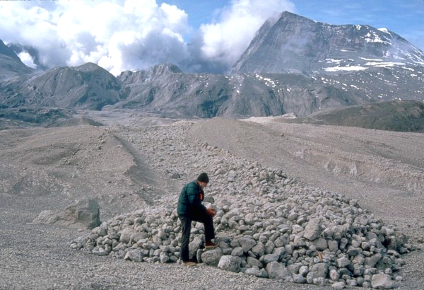
U.S. Geological Survey scientist examines pumice blocks at the edge of a pyroclastic flow from the May 18, 1980 eruption.  by  United States Geological Survey  -  Donald A. Swanson
Wikimedia.org
File:Pyroclastic Flow St. Helens.jpg
.....

Mount Saint Helens, State of Washington, United-States  7 September 2004  by  Tjk - Flickr
Wikimedia.org
File:Mount St Helens4.jpg

...

Crater / Plume image Mount St. Helens. United States Geological Survey photograph taken at 12:13:01 PDT (19:13:01 GMT) on October 1, 2004, by John Pallister
Wikimedia.org
File:MSH04 crater eruption image 1213PDT 10-01-04.jpg
.....
Mount St. Helens volcano, Washington, USA.  June 7th, 2012  by  Brigitte Werner (werner22brigitte)
Wikimedia.org
File:Mount St Helens USA 20120607.jpg
...
A panorama of Mount St. Helens  Decenber 18th ,2013  by   Eviatar Bach
Wkimedia.org
File:Panorama of Mount St. Helens.jpg
.....
Enhanced by Zemanta

According to new research, ongoing hydraulic fracking operations will only exacerbate seismic activity.

Fracking-linked earthquakes likely to worsen – seismologists

Published time: May 02, 2014 03:40


David McNew / Getty Images / AFP
Ongoing hydraulic fracking operations will only exacerbate seismic activity, leading to heightened earthquakes in areas where wastewater is injected deep underground, according to new research.
To unleash natural gas, hydraulic fracturing - or fracking - requires large volumes of water, sand, and chemicals to be pumped underground. Scientists attending the Seismological Society of America (SSA) annual meeting said Thursday that this storage of wastewater in wells deep below the earth’s surface, in addition to fracking’s other processes, is changing the stress on existing faults, which could mean more frequent and larger quakes in the future.
Researchers previously believed quakes that resulted from fracking could not exceed a magnitude of 5.0, though stronger seismic events were recorded in 2011 around two heavily drilled areas in Colorado and Oklahoma.
“This demonstrates there is a significant hazard,” said Justin Rubinstein, a research geophysicist at the US Geological Survey (USGS), according to TIME magazine. “We need to address ongoing seismicity.”
Not all of the more than 30,000 fracking disposal wells are linked to quakes, but an accumulating body of evidence associates an uptick in seismic activity to fracking developments amid the current domestic energy boom.
The amount of toxic wastewater injected into the ground seems to provide some clarity as to what causes the earthquakes. A single fracking operation uses two to five million gallons of water, according to reports, but much more wastewater ends up in a disposal well.

Read More Here
Enhanced by Zemanta