
Global Weather Phenomenon-Natural/Technological Disasters-Space Events-Epidemic/Biological Hazards- Nuclear Events : News Affiliate of Family Survival Protocol.com
Showing posts with label Philippines. Show all posts
Showing posts with label Philippines. Show all posts
Wednesday, December 23, 2015
The death toll from two storms which battered the Philippines rose to 45. Several towns remain under water and rainfall continues in northern regions,
Friday, December 18, 2015
Philippines - 5.2 Magnitude earthquake registered near the town of San Juan in Ilocos Sur

5.2-magnitude quake hits Ilocos Sur, aftershocks expected - Phivolcs
Updated 08:32 AM PHT Fri, December 18, 2015

Metro Manila (CNN Philippines) — A
5.2-magnitude earthquake struck near the town of San Juan in Ilocos Sur
on Thursday evening (December 17), according to the Philippine
Institute of Volcanology and Seismology (Phivolcs).
Aftershocks are expected, it added.
The United States Geological Survey (USGS), however, said the quake that struck at 8:44 p.m. had a magnitude of 5.4.
Aftershocks are expected, it added.
The United States Geological Survey (USGS), however, said the quake that struck at 8:44 p.m. had a magnitude of 5.4.
Strong quake felt in one town
Based on Phivolcs' earthquake intensity scale, an Intensity 5 or a strong quake was reported in the town of Sinait, more than 30 minutes drive from the town of San Juan.Read More Here
Tuesday, October 20, 2015
Tropical Storm - Philippines, Multiple areas, [Island of Luzon] : UPDATE

| October 17 2015 11:36 AM | Tropical Storm | Philippines | Multiple areas, [Island of Luzon] |
| |||||
| Updated: | Sunday, 18 October, 2015 at 09:52 UTC |
| Description | |
| Thousands of residents of the northern Philippines were forced to flee Sunday as Typhoon Koppu began its multiday battering of the region. The fierce storm is forecast to lumber over the country's main island of Luzon at an excruciatingly slow pace and dump huge amounts of rain on the rugged terrain, setting off floods and landslides. Koppu came ashore in the early hours of Sunday morning at super typhoon strength, ripping the roofs off buildings and uprooting trees in the coastal province of Aurora. "Through the night, we've had extremely ferocious wind, torrential rain," storm chaser James Reynolds told CNN from the town of Maddela. "The building I'm in -- the water's been coming in the windows." Roads and communications to three towns in Aurora province have been cut off by flooding and landslides, including Casiguran, where the typhoon made landfall, authorities reported. "Based on the report of the Philippine Army, there were many houses destroyed and trees uprooted in the three towns," the official Philippines News Agency said. The army and other agencies are trying to clear the routes to Casiguran, which has about 25,000 inhabitants, and the other towns, Dinalungan and Dilasag, it reported. In Baler, another town in Aurora, CNN Philippines reporter Paul Garcia said there was flooding in several neighborhoods. Surprised local residents said that while storms are common in the area, flooding is not, Garcia reported. Roughly 15,000 people are taking shelter in evacuation centers, the Philippines' disaster management agency said Sunday. That number is expected to rise as the storm, known in the Philippines as Lando, crawls across northern Luzon. No casualties have been reported so far, according to the agency. The storm was packing maximum sustained winds of 240 kph (150 mph) when it slammed into the eastern coast of Luzon, according to the U.S. military's Joint Typhoon Warning Center, although the Philippines' national weather agency measured the winds as being significantly weaker, at 185 kph. The typhoon has since lost some of its strength as it has moved over land. The typhoon is predicted to dawdle across northern Luzon for several days because of a ridge of high pressure over China blocking its progress farther north. That gives it longer than usual to soak the region's mountains and swell its rivers, threatening people who live downhill and downstream. "That's where the problem with the flash flooding comes in, because when you have all of this rain that keeps coming down over the same places over and over, that is likely to trigger mudslides and landslides in addition to flash flooding problems in ... some of the low-lying areas," Chinchar said. Officials reported dozens of flight cancellations, thousands of people stranded in ports and many municipalities without power. | |
| Updated: | Sunday, 18 October, 2015 at 12:06 UTC |
| Description | |
| Slow-moving Typhoon Koppu weakened after blowing ashore with fierce winds in the northeastern Philippines on Sunday, leaving at least one person dead and six others missing, while displacing 16,000 villagers, officials said. Army troops and police were deployed to rescue residents trapped in flooded villages in the hard-hit provinces of Aurora, where the typhoon blew ashore early Sunday, and Nueva Ecija, a nearby rice-growing province where floodwaters swamped farmlands at harvest time, officials said. After slamming into Aurora's Casiguran town after midnight Saturday, the typhoon weakened and slowed considerably, hemmed in by the Sierra Madre mountain range and a high pressure area in the country's north and another typhoon far out in the Pacific in the east, government forecaster Gladys Saludes said. Howling winds knocked down trees and electric posts, leaving nine entire provinces without power while floods and small landslides made 25 roads and bridges impassable. Authorities suspended dozens of flights and sea voyages due to the stormy weather, and many cities canceled classes on Monday. By Sunday afternoon, the typhoon had veered toward the north from its westward course and was tracked over mountainous Nueva Vizcaya province with sustained winds of 150 kilometers (93 miles) per hour and gusts of up to 185 kph (115 mph), according to the government's weather agency. Satellite images show that the typhoon appeared to be losing its eye, a sign of its dissipating strength, acting weather bureau chief Esperanza Cayanan told reporters, adding that Koppu was forecast to move at a slow pace of 5 kph (3 mph) across the north before exiting the main northern island of Luzon on Wednesday. While weather had begun to improve in some towns, and villagers had started to clear roads of fallen trees and debris, Koppu was still packing a ferocity that could set off landslides and flash floods, officials said. "There's still danger," Cayanan said. "We shouldn't be complacent." A teenager was pinned to death on Sunday by a fallen tree, which also injured four people and damaged three houses in suburban Quezon city in the Manila metropolis. A man was electrocuted in northern Tarlac province and two bodies were seen being swept by floodwaters in Nueva Ecija, but authorities were trying to determine whether those were typhoon-related deaths. Three fishermen were reported missing in northern Bataan province, along with three other men in Aurora's Baler town, according to the Office of Civil Defense. President Benigno Aquino III and disaster-response agencies have warned that Koppu's rain and winds may potentially bring more damage with its slow speed. But Saludes, the government forecaster, said there was less heavy rain than expected initially in some areas, including in Manila, but fierce winds lashed many regions. A wayward barge carrying coal and 10 crew drifted dangerously close to a breakwater and marina in Manila Bay. A tugboat positioned to prevent the barge from drifting away. Forecasters said the typhoon had a cloud band of 600 kilometers (372 miles) and could dump rain over much of Luzon. | |
| Updated: | Monday, 19 October, 2015 at 06:14 UTC |
| Description | |
| Army, police and civilian volunteers scrambled Monday to rescue hundreds of villagers trapped in their flooded homes and on rooftops in a northern Philippine province battered by slow-moving Typhoon Koppu. The typhoon blew ashore into northeastern Aurora province with fierce wind and heavy rains early Sunday, leaving at least two dead, forcing more than 16,000 villagers from their homes, and leaving nine provinces without electricity. But after its landfall, the typhoon weakened, hemmed in by the Sierra Madre mountain range and a high pressure area in the country's north and another typhoon far out in the Pacific in the east, government forecasters said. By Monday morning Koppu was located over Ilocos Norte province with winds of 74 miles per hour and gusts of up to 93 mph. Several of the affected provinces, led by Nueva Ecija, were inundated by flash floods that swelled rivers and cascaded down mountainsides, trapping villagers in their homes and on rooftops, said Nigel Lontoc of the Office of Civil Defense. "There were some people who needed to be rescued from the roofs of their homes," Lontoc told The Associated Press by telephone on Monday. "But our rescuers couldn't penetrate because the floodwaters were still high." Hundreds of soldiers, police and volunteers have converged on Nueva Ecija, a landlocked, rice-growing province in the heartland of the main northern Luzon island, to help villagers whose homes had been flooded, said Lontoc, adding there have been no deaths reported so far in Nueva Ecija's flooding. Erwin Jacinto, a 37-year-old resident of Nueva Ecija's Santa Rosa town, said the flooding turned his farmland into "nothing but mud." Jacinto spoke from the top of a high-level bridge that juts out from his flooded town and where dozens of farm villagers like him stayed in the open overnight with their families, and their pigs and chickens. Koppu's winds knocked down trees and electric posts, leaving nine provinces without power. Authorities suspended dozens of flights and sea voyages, and many cities canceled classes on Monday. A teenager was pinned to death on Sunday by a fallen tree, which also injured four people and damaged three houses in metropolitan Manila. In Subic town, northwest of Manila, a concrete wall collapsed and killed a 62-year-old woman and injured her husband, officials said. President Benigno Aquino III and disaster-response agencies had warned that Koppu's rain and winds may potentially bring more damage with its slow speed. But government forecasters said that there was less heavy rain than expected initially in some areas, including in Manila, but that fierce winds lashed many regions. Koppu, Japanese for "cup," is the 12th storm to hit the Philippines this year. An average of 20 storms and typhoons each year batter the archipelago, one of the world's most disaster-prone countries. | |
| Updated: | Monday, 19 October, 2015 at 12:21 UTC |
| Description | |
| At
least six people were confirmed dead due to incidents caused by Typhoon
Lando over the weekend, according to reports reaching authorities. The
National Disaster Risk Reduction and Management Council (NDRRMC), which
is based in Quezon City, has reported three fatalities as of late Monday
afternoon - one in Quezon City due to an accident involving a fallen
tree, one in Benguet due to landslide, and one in Zambales due to a
collapsed wall. Meanwhile, the Regional Disaster Risk and Reduction
Management in Region III reported four fatalities, including the one in
Zambales, as of 6 p.m. Monday. The three other fatalities were two from
Nueva Ecija and one in Tarlac. The latest NDRRMC report said five were
injured while one was missing. "Para po sa ating casualties, may naitala
po tayo na tatlo po na namatay, lima pong injured and isa po ang
kasalukuyan na nawawala," Mina Marasigan, NDRRMC spokesperson, said in a
press briefing in Camp Aguinaldo. "Yung sa ating mga namatay na mga
biktima, isa po mula sa Zambales, isa [sa] Quezon City, at isa po mula
Benguet na ang dahilan po nito ay landslide, dun po sa ating injured ay
isa pa rin po sa Zambales, apat po sa Quezon City," she added. An
earlier NDRRMC report identified two of the fatalities as 14-year-old
Aron Castillo, who was pinned down by a fallen tree in Quezon City, and
62-year-old Benita Famanilay, who was pinned down by a collapsed wall in
Subic, Zambales. A report by the Office of Civil Defense in the Cordillera Autonomous Region identified the latest fatality as Fernando Laso Gumpad, 57, a resident of Bakun, Benguet. According to the report, the victim went to tend to his farm at around 8 a.m. on Sunday but failed to return home in the afternoon, prompting his wife and son to look for him. "At around 6 p.m. of the same day, his wife and son decided to follow him and saw a landslide near their farm. The wife and son suspected that the victim was buried so they subsequently grabbed a crowbar and grabhoe to dig. The victims lifeless body was reported via cellphone call at around 12:30 a.m. on October 19, 2015," it said. Meanwhile, the Philippine Coast Guard said seven people died while two others were missing when a passenger banca capsized off Iloilo City on Sunday during the height of Typhoon Lando. Although reports like this indicate a higher death toll, Marasigan said NDRRMC only recorded three fatalities so far as reports need to undergo a stringent validation and confirmation process. "Katulad ng mga report na natatanggap natin mula sa ating ahensya, ito ay dumadaan pa sa confirmation at validation. Di tayo nagre-rely lang sa mga nakukuha natin mula sa social media at sa mga initial reports na binibigay. Ang mahalaga kasi dito ay may body count, may identification, at maitatala nating related nga ito sa bagyo," she said. Typhoon Lando has affected a total of 283,486 individuals in Regions 1, 2, 3, 5, Calabarzon (Calamba, Laguna, Batangas, Rizal, and Quezon) and the CAR. Of this number, 132, 621 individuals are staying with their families. Marasigan said the NDRRMC is continuously monitoring the rise of water in the Ambuklao, Binga and Magat Dams. A total of 36 road sections and 18 bridges, meanwhile, have been rendered impassable due to floods and possible landslides. | |
| Updated: | Monday, 19 October, 2015 at 14:29 UTC |
| Description | |
| Army, police and civilian volunteers rushed Monday to rescue hundreds of villagers trapped in their flooded homes and on rooftops in a northern Philippine province battered by slow-moving Typhoon Koppu, officials said. The typhoon blew ashore into northeastern Aurora province early Sunday, leaving at least 11 dead, forcing more than 65,000 villagers from their homes, and leaving nine provinces without electricity. By Monday afternoon, Koppu had weakened into a tropical storm over Ilocos Norte province with winds of 105 kilometers (65 miles) per hour and gusts of up to 135 kph (84 mph). Several of the affected provinces, led by Nueva Ecija, were inundated by floods that swelled rivers and cascaded down mountains, trapping villagers in their homes, said Nigel Lontoc of the Office of Civil Defense. "There were people who got trapped by the flood on their roofs, some were rescued already," Vice Mayor Henry Velarde of Nueva Ecija's Jaen town told The Associated Press by telephone, adding that about 80 percent of 27 villages in his farming town of more than 45,000 people were inundated by flood. When a flooded river swamped the villages, residents scrambled to safety but many failed to save their poultry and farm animals. Out of more than 5,000 ducks, for example, only about 1,000 were saved and many rice crops ready to be harvested in a few weeks turned into a muddy waste, he said. "Our rice farms looked like it was ran over by a giant flat iron," Velarde said. "All the rice stalks were flattened in one direction." Hundreds of soldiers, police and volunteers have converged on Nueva Ecija, a landlocked, rice-growing province in the heart of Luzon island, to help villagers whose homes had been flooded, said Lontoc. | |
| Updated: | Tuesday, 20 October, 2015 at 03:31 UTC |
| Description | |
| Koppu weakened from typhoon to tropical storm even as some areas of northern Philippines remained flooded, and authorities warned flooding and landslides could worsen. As of 4 a.m., local time Tuesday, Koppu's winds slowed to 95 kilometers per hour (59 mph) as its center left the main Philippine island of Luzon, the Philippine Atmospheric, Geophysical and Astronomical Services Administration said. Its winds were as strong as 185 kph (115 mph) just before hitting land Sunday. Aside from weakening, it is now forecast to turn east into the Pacific Ocean in the next few days, sparing Taiwan, the U.S. Navy Joint Typhoon Warning Center predicted. Sixteen people were dead and more than 60,000 forced to evacuate, Agence France-Presse reported. The worst single incident reported so far was the drowning of seven people on a ferry that capsized off the island of Guimaras Sunday. The casualty report may climb as information comes in from remote areas, or areas where transport and communication have been cut off. Authorities warned people in evacuation centers not to return to their homes, saying even if rains have abated, the water they left in the mountains will flow down for days, ABS-CBN News said. Rice and other crops were destroyed, and farm animals were killed by the wind, rains and floods, the Philippine Daily Inquirer and other media reported. The typhoon hit regions considered among the country's biggest sources of rice, the country's staple. That could revive inflation, which is low, or even increase world prices. The Philippines is one of the world's biggest importers of the grain. | |
UPDATE: 1 a.m. EDT -- The death toll from Koppu rose to 22 as more reports came in from northern Philippines, Agence France-Presse reported.
Meanwhile, the one-time supertyphoon, now classified as a tropical storm, weakened further, with winds of 85 kilometers per hour, according to the national weather agency.
Read More Here
Meanwhile, the one-time supertyphoon, now classified as a tropical storm, weakened further, with winds of 85 kilometers per hour, according to the national weather agency.
Read More Here
Saturday, October 17, 2015
Philippines braced as Typhoon Koppu makes landfall
BBC
Authorities
in the Philippines have cancelled flights and ordered thousands of
people in coastal areas to evacuate as Typhoon Koppu hits the country.
Koppu is predicted to bring three days of torrential rain, triggering floods, storm surges and possibly landslides.
Disaster officials said a few thousand people living in vulnerable coastal areas had already sought shelter.
Earlier, President Benigno Aquino made a televised warning, the first time he had done so since Super Typhoon Haiyan in 2013, which killed more than 6,300 people.

Billboards were removed as winds increased in Bulacan province, Luzon

Typhoon Haiyan caused devastation in the Philippines in 2013
Read More and Watch Videos Here
Monday, January 20, 2014
Biological Hazard - Philippines, Davao Oriental, Mati City : Mass Die Off (Fish)
Earth Watch Report - Biological Hazards - Mass Animal Deaths
.....
| Biological Hazard | Philippines | Davao Oriental, Mati City |
.....
| Description | |
| Fishermen in this city are at a quandary where and when they would
get their next income after the rains brought by low pressure area, now
tropical depression Agaton (international name: Lingling), as well as a
massive fish kill in the area, has made fishing almost impossible. The
stench of rotting fish along Barangay Dahican, Sitio Maitom, Kinhason 2
in Mati City is enough to get one's attention. The shoreline, which used
to be home to seashells, corals and drift woods, has become a deathbed
for hundreds of small fish species. "When it rains non-stop in this area
we usually see dead fishes floating but this is the first time I saw so
many of them dead," said fisherman Leonardo Bacor in the local dialect.
Mr. Bacor, who has spent most of his 57 years along these shores, was
among those who first saw thousands of dead fishes floating along the
Dahican River. Thousands of dead fishes have also been seen in nearby
Sitio Guang-Guang. He said it has been raining non-stop for almost a
week now and with almost a ton of fish floating dead along the river
most of the fishermen in the area like him have not been able to go
fishing this week. "The other fishermen who went out in the sea were
able to get very small fishes and in very small quantities after the
fish kill," he added. While he owns his boat, Mr. Bacor has become
frustrated with what is happening considering that he has seven children
to feed, two are now in college. He said they have not yet heard or has
received any support from the local government. Without other options for livelihood, Mr. Bacor and the other fishermen in the area gathered the small fishes washed ashore by the tide and left them to dry under the sun for bulad (dried fish). His wife Felicisima, said they had no choice but to eat the dried fish, which her husband made out of the dead fishes washed ashore by the tide. "We don't have banana or other crops to eat so the only option we have now is to eat the fish," she added. Rebecca Purgatoryo, a 54-year-old fish vendor, spent most of the days last week chatting with Felicisima and the other housewives in their area since she does not have anything to sell. She said she used to bring up to 30 kilograms of fish to sell everyday but with the fish kill, she has nothing. The fishermen said the people who know about the fish kill are wary about buying fishes in Mati's wet markets nowadays for fear that these might be contaminated with chemicals. Most of the residents in the area where the fish kill happened have been suffering from fever and gastrointestinal problems. They claim even their water sources might have been affected by whatever it is that caused the fish kill. Most of the residents source their water from deep wells. "We are not sure what caused the fish kill but we have already sent a fish sample to the laboratory to test for possible pesticide or other content," said Fatma M. Idris, regional director of the Bureau of Fisheries and Aquatic Resources (BFAR-11). Ms. Idris, who personally went to Sitio Maitom to check on the reported fish kill, said it is best to have the samples tested for content to put all doubts and rumors to rest as to what really caused the fish kill. BFAR-11's technical people also went to the area to get more water samples for laboratory testing. The city government of Mati has already created a task force to focus on the fish kill. Mayor Carlo Luis P. Rabat said he wants to clarify that they did not give any order for the cessation of fishing in the area despite the incident. However, he asked the fishermen to bury the dead fishes in safe areas. "If they make dried fishes out of the dead ones, then that might prove unhealthy and dangerous to health," he said. Officials from the BFAR's field office in Mati said there was zero visibility underwater in the areas where the fish kill happened. They also reported low water salinity and low oxygen levels in the water. Mr. Rabat was concerned about the period of recovery after the fish kill but Ms. Idris said it will depend on how long the area is cleared of the dead fishes first. "We have to remove all the dead fishes in the area and the waters before we can conduct a thorough cleanup," BFAR field staff Archie Samson said. |
|
| Biohazard name: | Mass. Die-off (fishes) |
| Biohazard level: | 0/4 --- |
| Biohazard desc.: | This does not included biological hazard category. |
| Symptoms: | |
| Status: | confirmed |
.....
.....

Monday, November 11, 2013
Food and Water Top Concerns for Philippine Survivors
Relief Efforts Underway in Devastated Philippine Areas
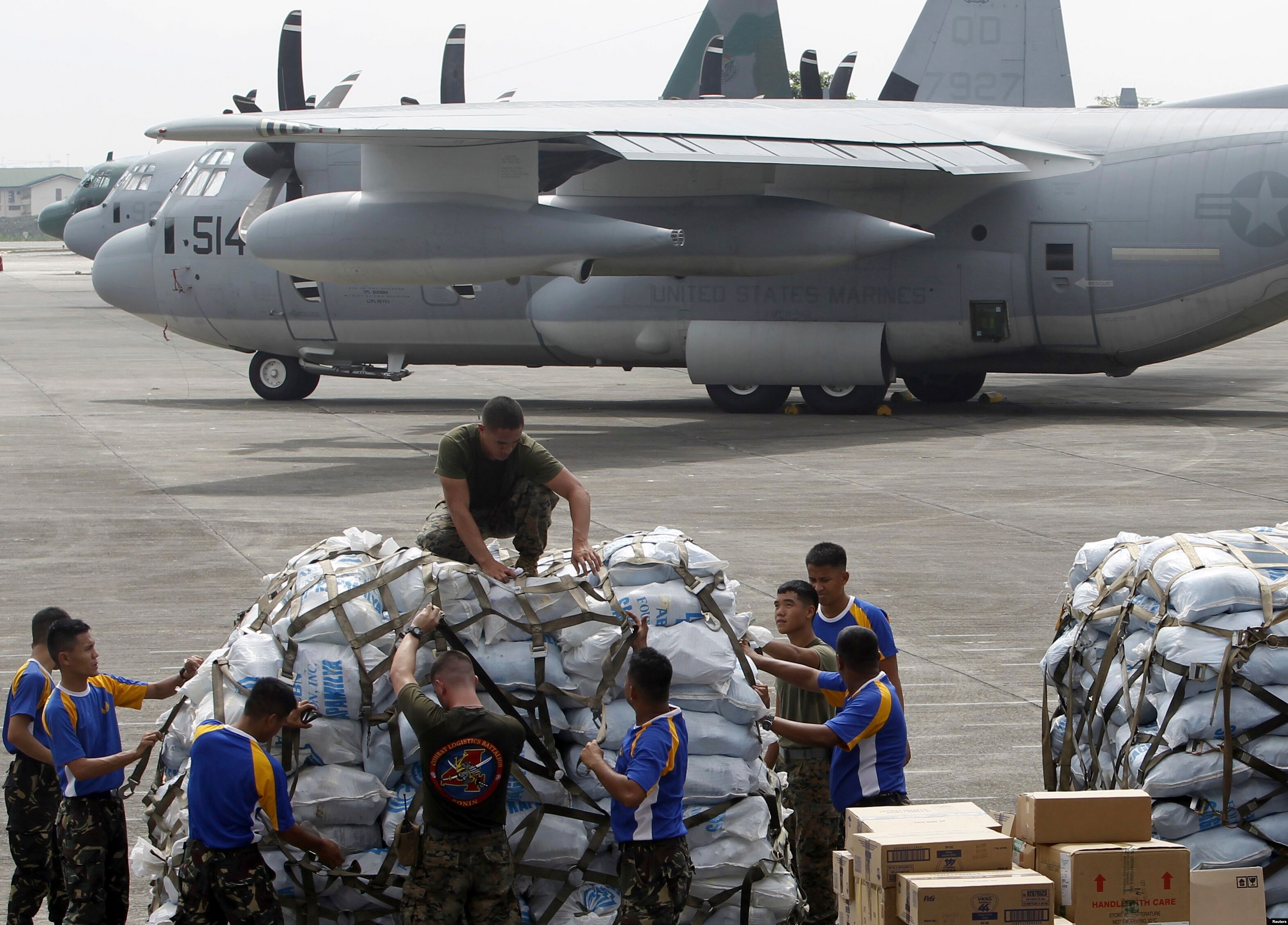
 Philippine and U.S. military personnel prepare to load relief goods on a U.S. C-130 plane for victims of Typhoon Haiyan, Villamor Air Base, Nov. 11, 2013.
November 11, 2013
MANILLA
— In the Central Philippines authorities are struggling to reach many
of the some 600,000 people displaced by Super Typhoon Haiyan. Officials
anticipate a death toll in the thousands.At the Villamor Air Force Base in Manila, C130 planes filled with relief goods are headed to one of the hardest hit cities, Tacloban in Leyte Province.
Some relief organizations say their provisions are taking three times longer to get there because so many land routes have been blocked by massive piles of debris from fallen houses and trees.
On the other side of the air field, around 400 people are waiting for a chance to catch a ride on one of the planes headed toward the devastation zone.
Among them is Tito Lucinareo, a father of two boys from a small town 25 kilometers outside Tacloban. He says he did manage to get a call through to one of his brothers who said the children survived the storm. But Lucinareo is not sure if they have food.
He says, “You think about whether your child is eating. Is he hungry? He likes to eat, especially biscuits.”
Lucinareo, his brother and cousins packed bags full of food that they plan to take to their hometown on foot.
Some in Tacloban have resorted to looting with reports of grocery stores and shopping malls being ransacked by people in search of food and clean water. The government said Sunday it would send additional military and police personnel to try to restore order.
Read More Here
Related articles


Sunday, November 10, 2013
Philippine typhoon death toll could reach 10,000
King 5.com

by KING Staff and Associated Press
Posted on November 9, 2013 at 11:07 AM
Updated yesterday at 5:50 PM
Regional police chief Elmer Soria said he was briefed by Leyte provincial Gov. Dominic Petilla late Saturday and told there were about 10,000 deaths on the island, mostly by drowning and from collapsed buildings. The governor's figure was based on reports from village officials in areas where Typhoon Haiyan slammed Friday.
Tacloban city administrator Tecson Lim said that the death toll in the city alone "could go up to 10,000.”

Hkg9176126
Credit: AFP/Getty Images
Residents
walk past debris of destroyed houses in the aftermath of Super Typhoon
Haiyan in Tacloban, eastern island of Leyte on November 9, 2013. One of
the strongest typhoons on record killed more than 100 people as savage
winds and giant waves flattened communities across the Philippines,
authorities said on November 9 while corpses lay amid the devastation.
AFP PHOTO / NOEL CELIS (Photo credit should read NOEL CELIS/AFP/Getty
Images)
The typhoon barreled through six central Philippine islands on Friday, wiping away buildings and leveling seaside homes. Most of the deaths and destruction were on Leyte Island, where Tacloban is located.
The typhoon weakened Sunday as it approached central and northern Vietnam where authorities evacuated more than 500,000 people.

Hkg9176050
Credit: AFP/Getty Images
People
walk among debris of fallen tress at Tacloban airport in the aftermath
of Super Typhoon Haiyan in Tacloban, eastern island of Leyte on November
9, 2013. One of the strongest typhoons on record killed more than 100
people as savage winds and giant waves flattened communities across the
Philippines, authorities said on November 9 while corpses lay amid the
devastation. AFP PHOTO / NOEL CELIS (Photo credit should read NOEL
CELIS/AFP/Getty Images)
The EMPACT Northwest Team is among the international groups on the way to help.
The group of medical specialists and first responders from the Puget Sound area have dropped everything and paid their own way to disasters in Japan, Pakistan, Haiti, Sierra Leone, Haiti and now the Philippines.

Hkg9175811
Credit: AFP/Getty Images
A
man (C) walks among debris of destroyed houses in the aftermath of
Super Typhoon Haiyan in Tacloban, eastern island of Leyte on November 9,
2013. One of the strongest typhoons on record killed more than 100
people as savage winds and giant waves flattened communities across the
Philippines, authorities said on November 9 while corpses lay amid the
devastation. AFP PHOTO / NOEL CELIS (Photo credit should read NOEL
CELIS/AFP/Getty Images)
"I think Seattle and Washington have a strong tie to the Pacific community, so I think it's a huge opportunity for us to be able to go help our brothers and sisters on that rim,” said Jake Gillanders.
HOW TO HELP
EMPACT Northwest: www.empactnorthwest.org/
Filipino Community of Seattle: http://fcseattle.org/
President Benigno Aquino III said the government's priority was to restore power and communications in isolated areas to allow for the delivery of relief and medical assistance to victims.
The Philippine Red Cross and its partners were preparing for a major relief effort "because of the magnitude of the disaster," said the agency's chairman, Richard Gordon.
The airport in Tacloban, a city of 200,000 located about 580 kilometers (360 miles) southeast of Manila, looked like a muddy wasteland of debris Saturday, with crumpled tin roofs and upturned cars. The airport tower's glass windows were shattered, and air force helicopters were busy flying in and out at the start of relief operations.
"The devastation is, I don't have the words for it," Roxas said. "It's really horrific. It's a great human tragedy.”
Defense Secretary Voltaire Gazmin said Aquino was "speechless" when he told him of the devastation the typhoon had wrought in Tacloban.
"I told him all systems are down," Gazmin said. "There is no power, no water, nothing. People are desperate. They're looting.”
U.S. Marine Col. Mike Wylie surveyed the damage in Tacloban prior to possible American assistance. "The storm surge came in fairly high and there is significant structural damage and trees blown over," said Wylie, who is a member of the U.S.-Philippines Military Assistance Group based in Manila.
U.S. Secretary of State John Kerry said in a statement that America "stands ready to help.”
Tacloban is near the Red Beach on Leyte Island where U.S. Gen. Douglas MacArthur waded ashore on October 20, 1944, fulfilling his famous pledge, "I shall return," made in March 1942 after President Franklin D. Roosevelt ordered him to relocate to Australia as Japanese forces pushed back U.S. and Filipino defenders.
Tacloban was the first city to be liberated by U.S. and Filipino forces and served as the Philippines' temporary capital for several months. It is also the home town of former Filipino first lady Imelda Marcos, whose nephew, Alfred Romualdez, is the city's mayor.
Read More and Watch Video Here
Related articles


Thursday, October 24, 2013
The ground rupture causing a 7.2 EQ in thePhilippines pushed the ground up two to three meters, cutting through mountains, roads and possibly settlement areas.

Residents stand next to a long earthen wall which formed following the
Oct. 15 earthquake in Barangay Anonang in Inabanga, Bohol. Phivolcs
scientists said the wall is the face of a previously unknown fault line
which caused the magnitude 7.2 quake. FREEMAN NEWS PHOTO
Inabanga is earthquake’s ‘ground zero’
By BenCyrus G. EllorinCebu Daily News
Geologists from the Philippine Institute of Volcanology and
Seismology (Phivolcs) found “ground zero” or the fault that triggered
the devastating magnitude 7.2 earthquake.
The discovery on Monday confirmed the existence of a previously unknown fault in western Bohol.
The Oct. 15 earthquake claimed around 200 lives and caused major infrastructure damage, including Spanish-era churches in Bohol and Cebu.
Immediately after the earthquake, Phivolcs said the tremor was caused by the movement of the East Bohol Fault.
The epicenter, first reported as Carmen town, was later adjusted to the general area between Sagbayan and Catigbian towns in north central Bohol based on the distribution of aftershocks.
Geologists found a 5-kilometer surface rupture that extended from barangay Anonang in Inabanga town to barangay New Anonang in Buenavista town.
“That fault motion caused the earthquake,” Renato Solidum, director of Phivolcs told ABS-CBN News Channel’s Talkback yesterday morning.
The ground rupture pushed the ground upward from two to three meters, cutting through mountains, roads and possibly settlement areas.
Phivolcs teams are still studying the extent of the fault line which could extend 100 kilometers or longer.
Aside from structural damage, residents in southern Cebu towns of Alegria and Badian and Carcar City have complained that ground water turned to “milo” brown.
Read More HereThe discovery on Monday confirmed the existence of a previously unknown fault in western Bohol.
The Oct. 15 earthquake claimed around 200 lives and caused major infrastructure damage, including Spanish-era churches in Bohol and Cebu.
Immediately after the earthquake, Phivolcs said the tremor was caused by the movement of the East Bohol Fault.
The epicenter, first reported as Carmen town, was later adjusted to the general area between Sagbayan and Catigbian towns in north central Bohol based on the distribution of aftershocks.
Geologists found a 5-kilometer surface rupture that extended from barangay Anonang in Inabanga town to barangay New Anonang in Buenavista town.
“That fault motion caused the earthquake,” Renato Solidum, director of Phivolcs told ABS-CBN News Channel’s Talkback yesterday morning.
The ground rupture pushed the ground upward from two to three meters, cutting through mountains, roads and possibly settlement areas.
Phivolcs teams are still studying the extent of the fault line which could extend 100 kilometers or longer.
Meanwhile,
aftershocks recorded by Phivolcs indicate a general distribution from
north Bohol to the offshores of Dalaguete, Alcoy and Boljoon towns in
southern Cebu.
The data was plotted on a map by Jessie Alaivar Floren, a private Geographic Informatino System expert in Cebu.
Aside from structural damage, residents in southern Cebu towns of Alegria and Badian and Carcar City have complained that ground water turned to “milo” brown.
Related articles


Monday, October 14, 2013
Philippines - 7.1 Magnitude Earthquake - 2km NE of Catigbian with 4 additional recorded events ranging in magnitude from 5.0 to 5.4 Monday October 14th, 2013
Earth Watch Report - Earthquakes

5 earthquakes in map area
M 5.2 - 6km SSW of Loon, Philippines 2013-10-14 20:37:57 UTC-05:00 22.6 km
M 5.0 - 3km E of Canmaya Diot, Philippines 2013-10-14 20:07:38 UTC-05:00 20.7 km
M 5.3 - 1km SE of Catigbian, Philippines 2013-10-14 19:33:51 UTC-05:00 69.1 km
M 5.4 - 6km NNE of Nueva Fuerza, Philippines 2013-10-14 19:29:06 UTC-05:00 87.8 km
M 7.1 - 2km NE of Catigbian, Philippiness 2013-10-14 19:12:32 UTC-05:00 20.0 km
M 7.1 - 2km NE of Catigbian, Philippines
2013-10-15 00:12:32 UTC

Event Time
- 2013-10-15 00:12:32 UTC
- 2013-10-15 08:12:32 UTC+08:00 at epicenter
- 2013-10-14 19:12:32 UTC-05:00 system time
Location
9.866°N 124.011°E depth=20.0km (12.4mi)Nearby Cities
- 2km (1mi) NE of Catigbian, Philippines
- 10km (6mi) SSE of Tibigan, Philippines
- 29km (18mi) NE of Tagbilaran, Philippines
- 42km (26mi) NE of Danao, Philippines
- 619km (385mi) SSE of Manila, Philippines
....
...

Tectonic Summary
Seismotectonics of the Philippine Sea and Vicinity
The Philippine Sea plate is bordered by the larger Pacific and Eurasia plates and the smaller Sunda plate. The Philippine Sea plate is unusual in that its borders are nearly all zones of plate convergence. The Pacific plate is subducted into the mantle, south of Japan, beneath the Izu-Bonin and Mariana island arcs, which extend more than 3,000 km along the eastern margin of the Philippine Sea plate. This subduction zone is characterized by rapid plate convergence and high-level seismicity extending to depths of over 600 km. In spite of this extensive zone of plate convergence, the plate interface has been associated with few great (M>8.0) ‘megathrust’ earthquakes. This low seismic energy release is thought to result from weak coupling along the plate interface (Scholz and Campos, 1995). These convergent plate margins are also associated with unusual zones of back-arc extension (along with resulting seismic activity) that decouple the volcanic island arcs from the remainder of the Philippine Sea Plate (Karig et al., 1978; Klaus et al., 1992).South of the Mariana arc, the Pacific plate is subducted beneath the Yap Islands along the Yap trench. The long zone of Pacific plate subduction at the eastern margin of the Philippine Sea Plate is responsible for the generation of the deep Izu-Bonin, Mariana, and Yap trenches as well as parallel chains of islands and volcanoes, typical of circum-pacific island arcs. Similarly, the northwestern margin of the Philippine Sea plate is subducting beneath the Eurasia plate along a convergent zone, extending from southern Honshu to the northeastern coast of Taiwan, manifested by the Ryukyu Islands and the Nansei-Shoto (Ryukyu) trench. The Ryukyu Subduction Zone is associated with a similar zone of back-arc extension, the Okinawa Trough. At Taiwan, the plate boundary is characterized by a zone of arc-continent collision, whereby the northern end of the Luzon island arc is colliding with the buoyant crust of the Eurasia continental margin offshore China.
Along its western margin, the Philippine Sea plate is associated with a zone of oblique convergence with the Sunda Plate. This highly active convergent plate boundary extends along both sides the Philippine Islands, from Luzon in the north to the Celebes Islands in the south. The tectonic setting of the Philippines is unusual in several respects: it is characterized by opposite-facing subduction systems on its east and west sides; the archipelago is cut by a major transform fault, the Philippine Fault; and the arc complex itself is marked by active volcanism, faulting, and high seismic activity. Subduction of the Philippine Sea Plate occurs at the eastern margin of the archipelago along the Philippine Trench and its northern extension, the East Luzon Trough. The East Luzon Trough is thought to be an unusual example of a subduction zone in the process of formation, as the Philippine Trench system gradually extends northward (Hamburger et al., 1983). On the west side of Luzon, the Sunda Plate subducts eastward along a series of trenches, including the Manila Trench in the north, the smaller less well-developed Negros Trench in the central Philippines, and the Sulu and Cotabato trenches in the south (Cardwell et al., 1980). At its northern and southern terminations, subduction at the Manila Trench is interrupted by arc-continent collision, between the northern Philippine arc and the Eurasian continental margin at Taiwan and between the Sulu-Borneo Block and Luzon at the island of Mindoro. The Philippine fault, which extends over 1,200 km within the Philippine arc, is seismically active. The fault has been associated with major historical earthquakes, including the destructive M7.6 Luzon earthquake of 1990 (Yoshida and Abe, 1992). A number of other active intra-arc fault systems are associated with high seismic activity, including the Cotabato Fault and the Verde Passage-Sibuyan Sea Fault (Galgana et al., 2007).
Relative plate motion vectors near the Philippines (about 80 mm/yr) is oblique to the plate boundary along the two plate margins of central Luzon, where it is partitioned into orthogonal plate convergence along the trenches and nearly pure translational motion along the Philippine Fault (Barrier et al., 1991). Profiles B and C reveal evidence of opposing inclined seismic zones at intermediate depths (roughly 70-300 km) and complex tectonics at the surface along the Philippine Fault.
Several relevant tectonic elements, plate boundaries and active volcanoes, provide a context for the seismicity presented on the main map. The plate boundaries are most accurate along the axis of the trenches and more diffuse or speculative in the South China Sea and Lesser Sunda Islands. The active volcanic arcs (Siebert and Simkin, 2002) follow the Izu, Volcano, Mariana, and Ryukyu island chains and the main Philippine islands parallel to the Manila, Negros, Cotabato, and Philippine trenches.
Seismic activity along the boundaries of the Philippine Sea Plate (Allen et al., 2009) has produced 7 great (M>8.0) earthquakes and 250 large (M>7) events. Among the most destructive events were the 1923 Kanto, the 1948 Fukui and the 1995 Kobe (Japan) earthquakes (99,000, 5,100, and 6,400 casualties, respectively), the 1935 and the 1999 Chi-Chi (Taiwan) earthquakes (3,300 and 2,500 casualties, respectively), and the 1976 M7.6 Moro Gulf and 1990 M7.6 Luzon (Philippines) earthquakes (7,100 and 2,400 casualties, respectively). There have also been a number of tsunami-generating events in the region, including the Moro Gulf earthquake, whose tsunami resulted in more than 5000 deaths.
More information on regional seismicity and tectonics

...
Four killed after 7.2 quake hits southern Philippines
Published time: October 15, 2013 00:39
Edited time: October 15, 2013 02:10
Edited time: October 15, 2013 02:10

The epicenter of the tremor was located at a depth of 56.8 km around Bohol island, to the north of Mindanao island, the US Geological Survey reports. Within minutes the quake was followed by two aftershocks of 5.4 and 5.3 magnitude.
Four people were killed in a building collapse on Bohol island, Reuters quoted disaster officials telling Philippines radio.
The governor of Bohol confirmed that several buildings, including a church and the former city hall, were damaged in the quake.
kayzie zepeda @kRayzie_me
@MovePH @rapplerdotcom Sto. Nino Church, in Cebu city after the quake. :( pic.twitter.com/0oBZBNmeBO

Read More Here
....
Subscribe to:
Posts (Atom)