Showing posts with label Tremors. Show all posts

Sunday, December 20, 2015

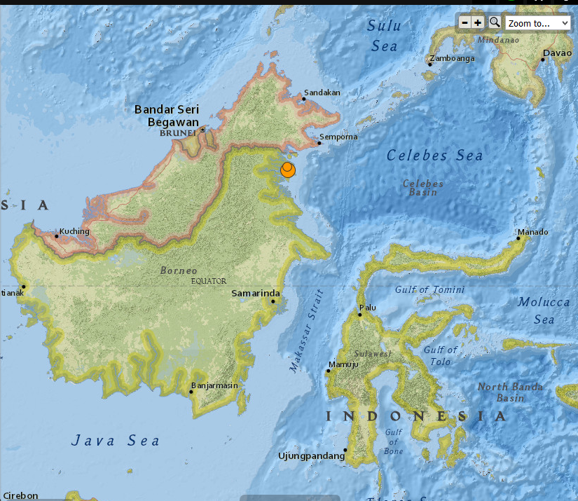
Indonesia - 6.0 Magnitude Earthquake with 4.6 registered not long after , 12/20/2015


 photo Indonesia 6.0 mag EQ 12.20.2015_zpstfcxfd6c.png
Indonesia 6.0 Magnitude EQ 12/20/2015

..........

2 earthquakes in map area

  1. M 4.6 - 38km ESE of Sembakung, Indonesia

    2015-12-20 21:38:39 UTC 10.0 km

  2. M 6.0 - 36km N of Tarakan, Indonesia

    2015-12-20 18:47:35 UTC 9.0 km


..........


...........

NOAA's National Weather Service

Tsunami.gov
Current date and time is: Dec 21, 2015 01:59 UTC
No Tsunami Warnings, Advisories or Watches are in effect
 
 
..........


The Japan Times

Borneo buffeted by strong, shallow M6.0 temblor but no tsunami threat: USGS

AFP-JIJI
 
A strong 6.0 magnitude earthquake struck Indonesia early on Monday, the U.S. Geological Survey (USGS) said, but no immediate damage or casualties were reported.

The quake, which was relatively shallow, struck the northeastern corner of Kalimantan on the Indonesian part of Borneo island, 34 km (21 miles) north of the coastal city of Tarakan, according to the USGS.

The agency reported the quake hitting at a depth of 22 km.

Indonesia’s tsunami warning center said there was no potential for the quake to trigger tsunami. There were also no immediate reports of damage.


Read More Here

...........

Wednesday, December 9, 2015

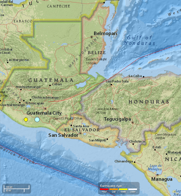
Guatemala - 5.7 Magnitude EQ recorded 12/07/2015. 4.4 Magnitude recorded 12/08/2015


..........
 photo Guatemala 5.7 Mag EQ_zps1pea8ugo.png
USGS
Guatemala   5.7 Magnitude EQ  12/07/2015
..........

2 earthquakes in map area

  1. M 4.4 - 1km NE of Nueva Concepcion, Guatemala

    2015-12-08 13:59:17 UTC 72.0 km

  2. M 5.7 - 1km NNW of Masagua, Guatemala

    2015-12-07 22:53:36 UTC 108.6 km


...........


............

Strong earthquake strikes near Escuintla in Guatemala, southwest of capital city

PUBLISHED Mon, December 07, 2015 - 6:27pm EST

Credit: Google
 
 
A strongly felt earthquake with a preliminary magnitude of 5.7 has struck near the city of Escuintla in south central Guatemala, not far from the capital, seismologists say. (more)

The earthquake, which struck at 4:53 p.m. local time on Monday, was centered next to Masagua about 12 kilometers (7 miles) southwest of Escuintla, or 59 kilometers (37 miles) southwest of Guatemala City. It struck about 108.6 kilometers (67.5 miles) deep, making it a relatively deep earthquake, according to the United States Geological Survey (USGS).


Read More Here


...........


Tuesday, December 1, 2015

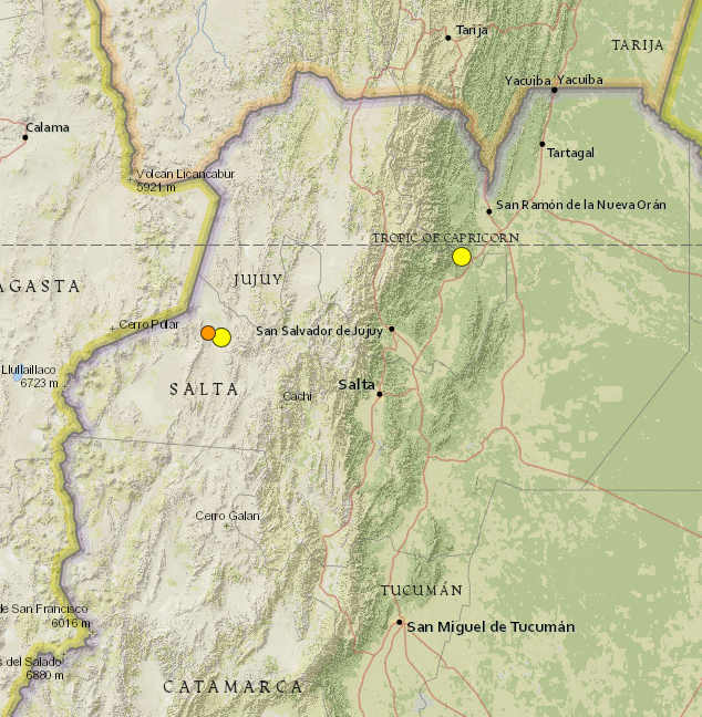
Argentina earthquake: Magnitude 5.9 hits Jujuy and Salta near San Salvador. Two additional quakes registered within the next two days at 5.1 and at 4.5


..........

Argentina 5.9 Magnitude EQ 11/29/2015 photo Argentina 5.9 mag EQ_zpst6sagbyf.png
USGS     Argentina 5.9 Magnitude EQ 
..........

3 earthquakes in map area

  1. M 4.5 - 80km W of San Antonio de los Cobres, Argentina

    2015-12-01 07:20:37 UTC 172.4 km

  2. M 5.1 - 67km W of San Antonio de los Cobres, Argentina

    2015-11-30 14:45:22 UTC 158.9 km

  3. M 5.9 - 17km NW of Yuto, Argentina

    2015-11-29 18:52:49 UTC 9.6 km


..........


...........

Argentina earthquake: Tremor hits Jujuy and Salta near San Salvador

PUBLISHED Sun, November 29, 2015 - 2:09pm EST
A strong earthquake with a preliminary magnitude of 5.9 has struck the provinces of Jujuy and Salta in northwest Argentina, near the city of San Salvador de Jujuy, seismologists say. (more)


The earthquake struck at 3:52 p.m. local time and was centered about 9 kilometers west of Yuto, or 91 kilometers northeast of San Salvador de Jujuy. It struck about 10 kilometers deep, making it a shallow earthquake, according to seismologists.

Residents in the region reported feeling the earthquake, but there was no immediate word on damage or casualties.


Read More Here

..........

Wednesday, November 25, 2015

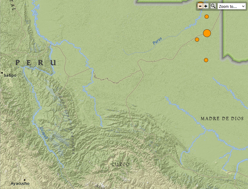
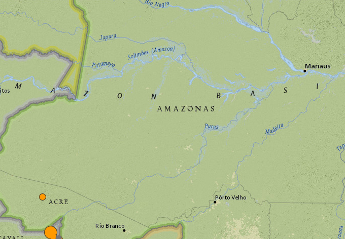
Peru and Brazil 7.6 Magnitude Earthquake. Total of 6 registered earthquakes ranging in magnitude from 4.6 to 7.6. 11/24/2015


Peru 7.6Mag Earthquake photo Peru 7.6 Mag earthquake_zpsnibcs37w.png
Peru 7.6 Magnitude Earthquake  11/24/2015
USGS
..........

4 earthquakes in map area

  1. M 4.6 - 150km WNW of Iberia, Peru

    2015-11-25 00:28:16 UTC 600.0 km

  2. M 4.5 - 189km NW of Iberia, Peru

    2015-11-24 23:55:20 UTC 616.9 km

  3. M 4.6 - 181km WNW of Iberia, Peru

    2015-11-24 23:44:12 UTC 595.1 km

  4. M 7.6 - 169km WNW of Iberia, Peru

    2015-11-24 22:45:38 UTC 600.6 km


..........


..........

NOAA's National Weather Service

Tsunami.gov
Current date and time is: Nov 25, 2015 20:34 UTC
No Tsunami Warnings, Advisories or Watches are in effect
 
..........
Globe with Earthquake Location

M7.6 - PERU-BRAZIL BORDER REGION

Preliminary Earthquake Report
Magnitude7.6
Date-Time
  • 24 Nov 2015 22:50:52 UTC
  • 24 Nov 2015 17:50:53 near epicenter
  • 24 Nov 2015 16:50:52 standard time in your timezone
Location10.070S 70.981W
Depth606 km
Distances
  • 208 km (128 mi) NW of Iberia, Peru
  • 212 km (131 mi) S of Tarauaca, Brazil
  • 221 km (137 mi) SSW of Feijo, Brazil
  • 264 km (163 mi) WNW of Cobija, Bolivia
  • 695 km (430 mi) ENE of Lima, Peru
Location UncertaintyHorizontal: 10.0 km; Vertical 7.0 km
ParametersNph = 90; Dmin = 320.8 km; Rmss = 1.13 seconds; Gp = 61°
Version =
Event IDus 100040x6 ***This event has been revised.
..........
Brazil  7.6 Mag Earthquake photo Brazil 7.6 Mag Earthquake_zpsht5uhemk.png
Brazil 7.6 Mag Earthquake   11/24/2015
USGS
..........

2 earthquakes in map area

  1. M 4.6 - 78km WSW of Tarauaca, Brazil

    2015-11-25 09:26:23 UTC 641.9 km

  2. M 7.6 - 210km S of Tarauaca, Brazil 2015-11-24 22:50:53 UTC 611.7 km


..........
..........

..........

Thursday, November 19, 2015

11/19/2015 : 8 Earthquakes registered in Lakeview, Oregon ranging in magnitude from 2.5 to 4.2


City Data . com
..........

8 earthquakes

  1. M 3.0 - 70km ESE of Lakeview, Oregon

    2015-11-19 05:50:58 UTC 10.7 km

  2. M 2.8 - 68km ESE of Lakeview, Oregon

    2015-11-19 05:48:48 UTC 11.3 km

  3. M 3.4 - 69km ESE of Lakeview, Oregon

    2015-11-19 05:27:21 UTC 10.8 km

  4. M2.7 - 69km ESE of Lakeview, Oregon

    2015-11-19 02:17:39 UTC 11.0 km


  5. M 2.5 - 69km ESE of Lakeview, Oregon 

    2015-11-19 02:15:32 UTC 10.5 km

  6. M 2.6 - 68km ESE of Lakeview, Oregon

    2015-11-19 02:01:42 UTC 11.4 km

  7. M 4.0 - 69km ESE of Lakeview, Oregon

    2015-11-19 01:50:17 UTC 12.1 km

  8. M 4.2 - 70km ESE of Lakeview, Oregon

    2015-11-19 01:40:02 UTC 12.9 km


..........


..........

..........


Wednesday, November 18, 2015

Violent Shaking Along The Ring Of Fire Continues A Progression Of Disasters That Began In September


The Economic Collapse

Are You Prepared For The Coming Economic Collapse And The Next Great Depression?
The Ring Of Fire - Photo from Wikipedia


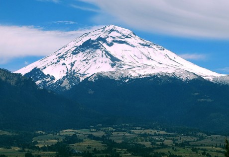
Have you noticed that seismic activity along the Ring of Fire appears to be dramatically increasing?  According to Volcano Discovery, 39 volcanoes around the world have recently erupted, and 32 of them are associated with the Ring of Fire.  This includes Mt. Popocatepetl which sits only about 50 miles away from Mexico City’s 18 million inhabitants.  If you are not familiar with the Ring of Fire, it is an area roughly shaped like a horseshoe that runs along the outer perimeter of the Pacific Ocean.  Approximately 90 percent of all earthquakes and approximately 75 percent of all volcanic eruptions occur along the Ring of Fire.  Just within the last 24 hours, we have witnessed a 4.4, a 5.4 and a 5.7 earthquake in Alaska, a 6.8 earthquake in Chile and 20 earthquakes in Indonesia of at least magnitude 4.3.  And as you will see below, this violent shaking along the Ring of Fire seems to continue a progression of major disasters that began back during the month of September.

For whatever reason, our planet suddenly seems to be waking up.  Unfortunately, the west coast of the United States is one of the areas where this is being felt the most.  The little city of San Ramon, California is about 45 miles east of San Francisco, and over the past several weeks it has experienced a record-breaking 583 earthquakes

A total of 583 small earthquakes have shaken San Ramon, California, in the last three weeks or so – more than five times the record set 12 years ago, according to the latest US Geological Survey updates.

“It’s the swarm with the largest number of total earthquakes in San Ramon,” said USGS scientist David Schwartz, who is more concerned about the size of quakes than he is the total number of them. Still, the number tops the previous record set in 2003, when 120 earthquakes hit over 31 days, with the largest clocking in at a magnitude of 4.2.

Could this be a prelude to a major seismic event in California?

We shall see what happens.

Meanwhile, records are being shattered in the middle part of the country as well.

For instance, the state of Oklahoma has already set a brand new yearly record for earthquakes

The state recorded its 587th earthquake of 3.0 magnitude or higher early this week, breaking the previous record of 585. That record was set for all of 2014, meaning that Oklahoma has now had more 3.0 magnitude or higher earthquakes so far in 2015 than it did in all of 2014. So far this year, E&E News reports, Oklahoma’s averaged 2.5 quakes each day, a rate that, if it continues, means the state could see more than 912 earthquakes by the end of this year.

Oklahoma has also experienced 21 4.0 magnitude or greater earthquakes so far this year — an increase over last year, which saw 14.

And just over this past weekend there was a very disturbing series of earthquakes in the state

Starting with a magnitude-4.1 temblor at 5:11 a.m. close to the Oklahoma-Kansas border, the region experienced a series of six earthquakes within a 75-minute period Saturday morning, the U.S. Geological Survey reported on its website.

The largest earthquake Saturday morning was the 4.1, which had an epicenter nine miles northwest of Medford, Okla., 59 miles southwest of Wichita.

That was followed by five more quakes near Medford with magnitudes of 2.5, 2.8, 2.5, 3.1 and 2.9 – the last of which came at 6:24 a.m.

A seventh earthquake – this one a magnitude-4.2 temblor – was recorded at 12:29 p.m., 10 miles north-northwest of Medford.

So why aren’t more Americans alarmed that these records are being broken?


Read More Here

Wednesday, November 11, 2015

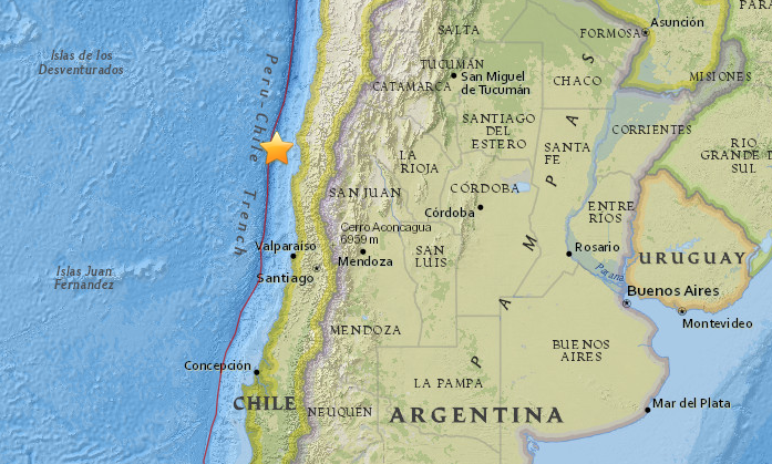
Two Earthquakes - Magnitude 6.9 - 93km NW of Coquimbo, Chile. Total of 13 earthquakes registered ranging in magnitude from 4.0 to 6.9.

.


6.9 quake, powerful aftershocks strike off Chilean coast

 
© earthquake.usgs.gov
A 6.9 magnitude earthquake has struck off the coast of Chile, some 100 kilometers west of Coquimbo, according to USGS. 

The epicenter of the earthquake was located at a depth of just 10 kilometers (6.2 miles), according to the United States Geological Survey, which initially reported it as having a magnitude 6.6.

USGS reports a M6.6 88km NW of Coquimbo, Chile on 11/11/15 @ 1:54:37 UTC http://earthquake.usgs.gov/earthquakes/eventpage/us10003x8t 

13 earthquakes in map area

  1. 5.1 78km NW of Coquimbo, Chile 2015-11-11 03:07:49 UTC 15.2 km
  2. M 6.9 - 98km NW of Coquimbo, Chile

     2015-11-11 02:46:19 UTC 10.0 km

  3. 5.1 83km NW of Coquimbo, Chile 2015-11-11 02:23:38 UTC 10.0 km
  4. 4.9 81km NW of Coquimbo, Chile 2015-11-11 02:18:08 UTC 35.0 km
  5. 4.8 89km NW of Coquimbo, Chile 2015-11-11 02:14:39 UTC 10.0 km
  6. 4.9 76km NW of Coquimbo, Chile 2015-11-11 02:06:36 UTC 10.0 km
  7. M 6.9 - 93km NW of Coquimbo, Chile

    2015-11-11 01:54:37 UTC 10.0 km

  8. 4.4 92km NW of Coquimbo, Chile 2015-11-10 23:48:24 UTC 10.0 km
  9. 4.1 36km SW of Ovalle, Chile 2015-11-10 19:38:22 UTC 50.1 km
  10. 4.0 33km NNE of Calama, Chile 2015-11-10 18:06:20 UTC 111.1 km
  11. 5.7 35km NE of Calama, Chile 2015-11-10 17:48:22 UTC 112.5 km
  12. 4.6 33km SW of Ovalle, Chile 2015-11-10 12:58:37 UTC 37.6 km
  13. 4.4 101km WNW of Coquimbo, Chile 2015-11-10 11:43:46 UTC 10.0 km

..........


..........


..........

NOAA's National Weather Service

Tsunami.gov
 
Current date and time is: Nov 11, 2015 06:32 UTC
No Tsunami Warnings, Advisories or Watches are in effect
 
..........

Wednesday, November 4, 2015

A series of three earthquakes shook Arizona Sunday night. The epicenters were just north of Black Canyon City in central Arizona off Interstate 17.


4.1-magnitude Arizona earthquake shakes metro Phoenix


Residents reported shaking across metro Phoenix on Sunday night amid at least three quakes that struck near Black Canyon City.


A string of earthquakes north of Phoenix gave the Valley a rare jolt Sunday night, and the largest – a magnitude 4.1 just before 11:30 p.m. – rattled homes across the region.

The series of at least three Arizona earthquakes generated no reports of notable damage, but left people swaying or stunned from Black Canyon City, closest to the epicenter, to Camp Verde and across metro Phoenix as far as Queen Creek.

Michael Conway of the Arizona Geological Survey said Monday morning that scientists had not identified the causative fault line yet. Because the earthquake was small and did not rupture the ground, it will be hard to identify where it originated, Conway said.He also said there will be aftershocks over the next few days, many of them too small to feel.


Read More Here

One Of The Most Dangerous Volcanoes In North America Is Roaring To Life


End Of The American Dream

The American Dream Is Becoming A Nightmare And Life As We Know It Is About To Change
Popocatepetl - from Wikipedia

More than 25 million people live in the vicinity of North America’s 2nd-highest volcano, and in recent weeks this volcano has been steadily rumbling and has been spewing out massive amounts of black smoke and ash.  I have previously written about “the most dangerous mountain in the United States” (Mt. Rainier), but if the volcano that I am talking about today experiences a full-blown explosive eruption it could potentially be a cataclysmic event beyond what most of us would dare to imagine.  Popocatepetl is an Aztec word that means “smoking mountain”, and it is also the name of a giant volcano that sits approximately 50 miles away from Mexico City’s 18 million residents. 

“Popo”, as it is called by locals, was dormant for much of the 20th century, but it came back to life in 1994.  And now all of this unusual activity in recent weeks has many wondering if a major eruption may be imminent.

Historians tell us that Popocatepetl had a dramatic impact on the ancient Aztecs.  Giant mud flows produced by massive eruptions covered entire Aztec cities.  In fact, some of these mud flows were so large that they buried entire pyramids in super-heated mud.

But we haven’t witnessed anything like that in any of our lifetimes, so it is hard to even imagine devastation of that magnitude.

In addition to Mexico City’s mammoth population, there are millions of others that live in the surrounding region.  Overall, there are about 25 million people that live in the immediate vicinity of Popocatepetl.  Thankfully, we haven’t seen a major eruption of the volcano in modern times, but at some point that will change.

As most of you already know, Mexico sits on the “Ring of Fire” that stretches along the outer rim of the Pacific Ocean.  Over the past couple of years seismic activity throughout this area has started to really heat up, and according to Volcano Discovery there are dozens of volcanoes associated with the Ring of Fire that have recently erupted.


Read More Here

Wednesday, October 14, 2015

Farmhouses are disappearing across the Groningen countryside as a peculiar, profound environmental crisis grips the province. Fracking in the Netherlands


the guardian

Shell and Exxon's €5bn problem: gas drilling that sets off earthquakes and wrecks homes

Groningen has been one of Europe’s richest gas fields for 30 years, and thousands of people say their homes have been damaged by the tremors that drilling sets off. Now a class action may finally bring them compensation – and force a rethink of European energy security
Annemarie Heite, whose home in Groningen has been scheduled for demolition after earthquakes caused by oil drilling.
‘Nobody is taking this seriously, not the school or the mayor, no one’ … Annemarie Heite, whose home in Groningen has been scheduled for demolition after earthquakes caused by oil drilling. Photograph: Hans Knikman/Demotix 
 
 
Five years ago, Annemarie Heite and her husband, Albert, bought their dream home; a traditional 19th-century farmhouse in Groningen province in the northern Netherlands. The couple planned to raise their two young daughters in this charming corner of the Dutch countryside. “Then, the living was still easy, and affordable,” Annemarie says, her tone bittersweet and nostalgic. Today, their house is scheduled for demolition.

Hundreds of earthquakes have wrecked the foundations of the Heites’ home and made it unsafe to live in. Annemarie’s biggest fear is the safety of her daughters. She points to a room. “This is where my children sleep,” she says, “and everyday I’m just picking up pieces of bricks and stuff from the ceiling.”

Heite fears that her children may not be any safer at school. Her daughter Zara goes to a local primary school that has not been structurally reinforced to withstand strong earthquakes. “I feel powerless. It feels like I can’t do anything,” Heite says. “It’s not like I’m a frantic, hysterical person, but nobody is taking this seriously, not the school or the mayor, no one.”
Next door, Heite’s neighbour’s farmhouse is already a pile of rubble, which yellow JCBs are clearing away. “It’s collapsed. It’s gone,” Heite says. “They lived there for 30 years … and over there behind the trees, they demolished another house.”

Farmhouses like Heite’s are disappearing across the Groningen countryside as a peculiar, profound environmental crisis grips the province. At the heart of it are two oil companies, Shell and Exxon Mobil, and a government that, for two decades, denied responsibility for its actions and ignored the voices of citizens and scientists. The scandal has already cost the oil companies €1.2bn [£880m], but last month a landmark court ruling gave the victims fresh hope that their voices could be ignored no longer. And if they are right, the consequences could be profound: a compensation bill that could stretch to more than €5bn in Holland, an energy security headache for Europe, and an invocation for the world to think about the real cost of burning fossil fuels.


Annemarie Heite’s earthquake-damaged family home in Groningen
Pinterest
 
‘Everyday I’m just picking up pieces of bricks and stuff from the ceiling’ … Heite’s earthquake-damaged family home. Photograph: Hans Knikman/Demotix 


Read More Here

Thursday, October 8, 2015

Moderate earthquake: M5.1 quake has struck near Nikolski in Alaska


..........

Moderate earthquake: M5.1 quake has struck near Nikolski in Alaska

8 Oct , 2015  
Earthquake location 52.1137S, -171.8043W
A moderate earthquake magnitude 5.1 (ml/mb) has struck on Wednesday, 56 km SSE of Nikolski, Alaska (35 miles) The temblor was reported at 12:43:27/12:43 pm (local time epicenter) at a depth of 39.86 km (25 miles). Did you feel it? Was there any damage?
,
..........
9 earthquakes in map area
  1. M 4.8 - 40km WSW of Amatignak Island, Alaska 2015-10-08 13:23:01 UTC 51.7 km

  2. M 3.7 - 88km NNW of Talkeetna, Alaska 

    2015-10-08 12:33:49 UTC 129.7 km

  3. M 4.5 - 54km SSE of Nikolski, Alaska,

    2015-10-08 09:04:46 UTC 37.9 km

  4. M 2.6 - 160km S of Cape Yakataga, Alaska, 2015-10-08 06:08:43 UTC 33.8 km

  5. M 2.6 - 160km S of Cape Yakataga, Alaska 2015-10-08 04:35:21 UTC 9.2 km

  6. M 2.7 - 96km SSE of Old Iliamna, Alaska

    2015-10-08 02:03:30 UTC 124.6 km

  7. M 5.0 - 59km SSE of Nikolski, Alaska

    2015-10-08 00:05:56 UTC 30.8 km

  8. M 5.1 - 56km SSE of Nikolski, Alaska

    2015-10-07 23:43:27 UTC 39.9 km

  9. M 3.0 - 82km WSW of Cantwell, Alaska

    2015-10-07 22:48:32 UTC 113.5 k

..........
Earthquakes today

Earthquakes in Alaska

More earthquakes occur in Alaska than anywhere else in the United States. Alaska can have up to 24,000 earthquakes every year, according to the U.S. Seismology Department. Alaska is in the place where two major tectonic plates, continental and oceanic, bump into one another. It is the North Pacific Plate and the North American Plate that causes activity. Most of the activity happens in Cook Inlet, or north of Denali in the central region. The 1964 Alaskan earthquake, also known as the Great Alaskan Earthquake and Good Friday Earthquake, was a megathrust earthquake that began at 5:36 P.M. AST on Good Friday, March 27. Across south-central Alaska, ground fissures, collapsing structures, and tsunamis caused about 139 deaths. Lasting four minutes and 38 seconds, it was the most powerful recorded earthquake in U.S. and North American history. It had a moment magnitude of 9.2, making it the second strongest earthquake in recorded history.. Earthquakes in Alaska today. All information you need to know about Alaska. Find articles, news, videos, pictures, links and facts about Alaska. Alaska Earthquake latest breaking news and updates, information, look at maps, watch videos and view photos and more. Join the discussion on Facebook or Twitter and find more about temblor, tremor or quakes that have occurred in Alaska quakes. List of recent and latest earthquakes recorded in and close to this area today and now. We list magnitude, date, epicentral localization, maps, wave forms, the largest, tsunami hazards and last earthquakes in this state/area, Alaska.
..........
Alaska Earthquake Information Center

Link to Recent EarthquakesRecent Earthquakes


Magnitude and Age Legend for Earthquakes
..........

Thursday, October 1, 2015

Earthquake Hits Indonesia Reaching Papua New Guinea


earthquake
A magnitude 5.5 earthquake shook Abepura, Indonesia at 23:20 UTC. The tremor reached 1078 km to Papua New Guinea, which has experienced several tremors already.
Both Indonesia and Papua New Guinea are on “Green Alert,” this means people are unlikely to have been injured and there was little to no damage. This area is prone to earthquakes because they are on the boundary of the Australia-Pacific plate, which experiences a great deal of seismic activity. However, the many tremors that have impacted Indonesia and Papua New Guinea have caused landslides and other secondary hazards. This can cause not only loss of lives but a loss in the economy of these countries.
Due to the certainty of seismic activity, both countries must ensure the structure of their buildings by reinforcements that can resist the shaking from earthquakes. The reinforced buildings are able to withstand earthquakes, contribute to public safety, and the economy.
Read More Here

..........

7 Days, Magnitude 2.5+

14 earthquakes in map area
  1. M 4.6 - 81km N of Dobo, Indonesia  2015-10-02 01:58:18 UTC 29.3 km

  2. M 5.4 - 42km W of Abepura, Indonesia 2015-09-29 23:20:50 UTC 19.0 km

  3. M 5.0 - 63km ESE of Tobelo, Indonesia 2015-09-29 17:50:14 UTC 53.9 km

  4. M 4.9 - 81km WNW of Tobelo, Indonesia  2015-09-29 14:39:13 UTC 100.8 km

  5. M 4.7 - 105km WSW of Tual, Indonesia  2015-09-29 14:03:28 UTC 50.2 km

  6. M 4.7 - 27km NNW of Tambulatana, Indonesia 2015-09-28 14:55:34 UTC 85.1 km

  7. M 4.4 - 91km S of Cikamurang, Indonesia  2015-09-28 14:10:08 UTC 35.0 km

  8. M 4.6 - 215km S of Kalapagenep, Indonesia 2015-09-27 07:04:58 UTC 21.1 km

  9. M 5.6 - 192km WNW of Saumlaki, Indonesia 2015-09-27 02:56:13 UTC 109.8 km

  10. M 4.7 - 73km WSW of Amahusu, Indonesia 2015-09-26 14:28:49 UTC 225.9 km

  11. M 4.6 - Kepulauan Barat Daya, Indonesia  2015-09-26 11:31:43 UTC 172.3 km

  12. M 4.9 - 24km N of Sorong, Indonesia  

    2015-09-25 21:53:22 UTC 37.4 km

  13. M 4.3 - 9km SE of Pundong, Indonesia 

    2015-09-25 13:28:53 UTC 5.1 km

  14. M 4.9 - 71km NW of Boroko, Indonesia  

    2015-09-25 08:47:52 UTC 45.8 km


..........


..........
Current date and time is: Oct 2, 2015 04:47 UTC
No Tsunami Warnings, Advisories or Watches are in effect
 

..........

Sunday, September 27, 2015

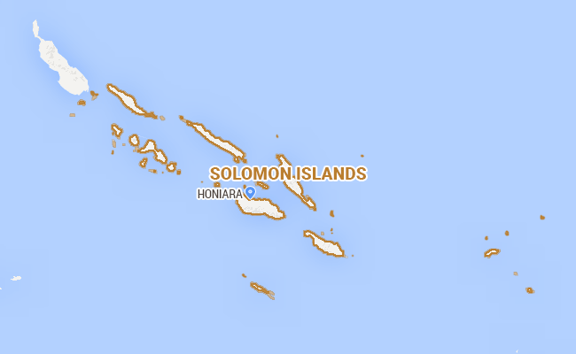
6.0-Magnitude Earthquake Hits Off Solomon Islands: USGS


6.0-Magnitude Earthquake Hits Off Solomon Islands: USGS
A 6.0-magnitude quake hit off the Solomon Islands
Sydney:  A 6.0-magnitude earthquake struck off the Solomon Islands early Friday, US geologists said, but there were no initial reports of damage and no tsunami warnings were issued.
The quake struck 98 kilometres (60 miles) southeast of the capital Honiara in the early hours of Friday (around 1600 GMT Thursday) at a depth of approximately 23 kilometres (14 miles), USGS said.

Read More Here


Related Articles