Global Weather Phenomenon-Natural/Technological Disasters-Space Events-Epidemic/Biological Hazards-
Nuclear Events :
News Affiliate of Family Survival Protocol.com
The
site is leaking up to 145,000 pounds per hour, according to the
California Air Resources Board. In just the first month, that’s added up
to 80,000 tons, or about a quarter
of the state’s ordinary methane emissions over the same period. The
Federal Aviation Administration recently banned low-flying planes from
flying over the site, since engines plus combustible gas equals kaboom.
Steve
Bohlen, who until recently was state oil and gas supervisor, can’t
remember the last time California had to deal with a gas leak this big.
“I asked this question of our staff of 30 years,” says Bohlen. “This is
unique in the last three or four decades. This is an unusual event,
period.”
Families living downwind of the site have also noticed
the leak—boy, have they noticed. Methane itself is odorless, but the
mercaptan added to natural gas gives it a characteristic sulfurous
smell. Over 700 households have at least temporarily relocated, and one
family has filed a lawsuit against the Southern California Gas Company
alleging health problems from the gas. The gas levels are too low for
long-term health effects, according to health officials, but the odor is
hard to ignore.
Given both the local and global effects of the
gas leak, why is it taking so long to stop? The answer has to do with
the site at Aliso Canyon, an abandoned oil field. Yes, that’s right,
natural gas is stored underground in old oil fields. It’s common
practice in the US, but largely unique to this country. The idea goes
that geological sites that were good at keeping in oil for millions of
years would also be good at keeping in gas.
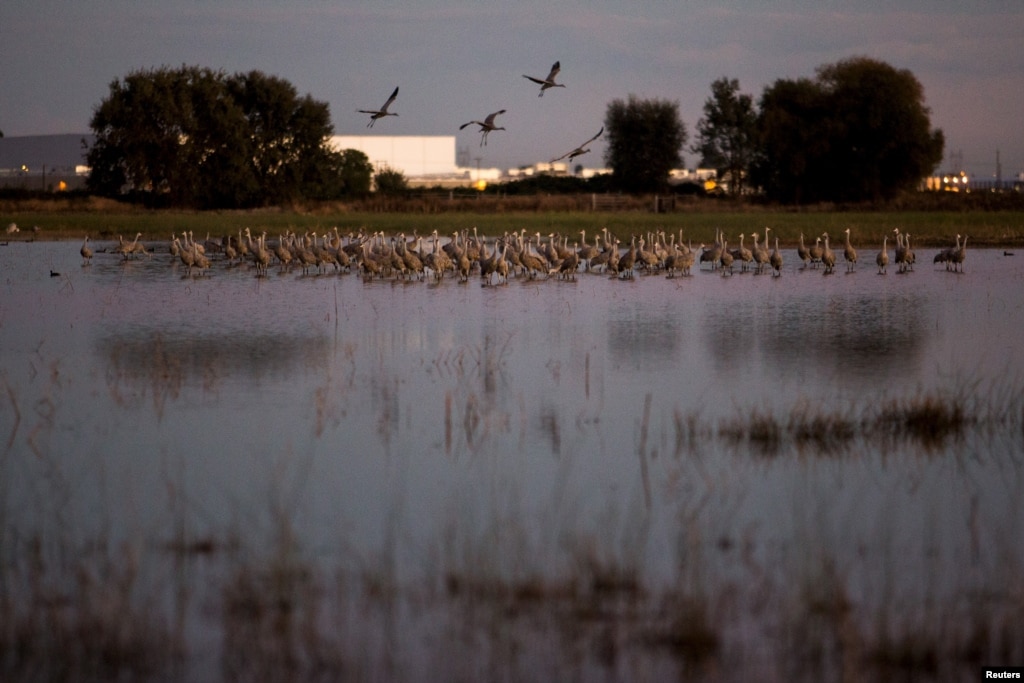
California Drought Affects Winter Refuges for Migratory Birds
Sandhill
cranes land in flooded fields at the Sandhill Crane Reserve near
Thornton, California, Nov. 3, 2015. The state's ongoing drought has left
millions of waterfowl that migrate from northern climes to California
with fewer places to land, seek food.
Reuters
November 07, 2015 10:43 AM
LODI, CALIFORNIA—With
their red heads, 2.13-meter (7-foot) wingspan and a trilling call,
migrating Sandhill Cranes provide a dramatic sunset spectacle as they
land by the thousands in wetlands near Sacramento each night during the
fall and winter.
But the state's ongoing drought has left the
cranes, along with millions of other waterfowl that migrate from Canada
and other northern climes to spend the winter in California, with fewer
places to land, threatening their health as they crowd in on one another
to seek shelter and food.
"They're left with fewer and fewer
places to go, which will start to have impacts on their population,"
said Meghan Hertel, who works on habitat issues for the Audubon Society
in California. "They can die here from starvation or disease or be
weaker for their flight back north."
Beloved sight
The cranes are a beloved sight in California's Sacramento and San Joaquin Valleys when they arrive each fall.
Tourists
flock to see them as they take off en masse at dawn or land in a series
of swooping, trilling groups as the sun goes down.
Sky5 aerials show a buckling Vasquez Canyon Road in Canyon Country. (Credit: KTLA)
A
portion of Vasquez Canyon Road remained closed indefinitely Friday
after a landslide prompted buckling and significant damage along a
2-mile stretch in the Canyon Country area.
KTLA reporter Mark Mester stands next to Vasquez Canyon Road, which continued to buckle on Nov. 20, 2015. (Credit: KTLA)
"This
isn’t just the road; it’s the mountain itself that’s moving and it’s
pushing the road up," said Paul Funk with L.A. County Department of
Public Works.
The roadway was closed Thursday between Lost Creek
Road and Vasquez Way after public works officials first noticed the
shift around 10:30 that morning.
The closure was said to be indefinite and would likely last for "a long time," Funk said.
In less than 24 hours, the roadway changed from appearing slightly tilted to being very badly damaged.
More
than half the road was lifted some 15 feet in the air, with dirt from
the neighboring hillside sliding underneath and causing significant
cracks.
Monterey Bay anchovy numbers in decline, groups say
By Samantha Clark
Santa Cruz Sentinel
Posted: 10/30/2015 12:32:04 PM PDT4 Comments | Updated: 19 days ago
Anchovies
fill a hatch aboard the El Dorado as workers unload the fishing boat at
the Moss Landing Harbor on October 16, 2015. The boat is owned by Frank
Aliotti Senior. (David Royal - Monterey Herald) ( David Royal )
Frank Aliotti Jr. moves a vacuum hose while unloadin anchovies from the El... ( David Royal )
SANTA
CRUZ -- For at least the past three years, humpback whales have been
putting on a show in the Monterey Bay. Feasting and frisking, the
40-foot-long, 40-ton leviathans create in dizzying displays.
Locals have never seen anything like it. But things have changed.
"Since
late September, the whale numbers have decreased, their behavior has
changed and their food, anchovies, are less abundant," said Nancy Black,
marine biologist and owner of Monterey Bay Whale Watch. "We were seeing
carpets just thick of anchovies for almost a mile. Now all we're seeing
is spots."
Whale watching tour companies and conservationists
claim the anchovy population has "collapsed" due to environmental
reasons so fishing limits remain too high.
Plenty of anchovies in Monterey Bay, but maybe not elsewhere
Monterey
Fish Company worker Geronimo Hernandez feeds anchovies from a chute
into iced bins while unloading the El Dorado fishing boat at the Moss
Landing Harbor on October 16, 2015. The boat is owned by Frank Aliotti
Senior. (David Royal - Monterey Herald)
A fisherman moves anchovies toward a vacuum tube inside the hatch
aboard the El Dorado as workers unload the fishing boat at the Moss
Landing Harbor on Friday. The boat is owned by Frank Aliotti Sr. David Royal — Monterey Herald
Monterey >> Things are shifting for fishermen in Monterey Bay.
Market squid are disappearing, and in their place, fishing boats are reeling in piles of anchovies.
But while they appear abundant, conservation groups warn that the forage fish may be at their lowest levels since the 1950s.
“It’s
an anomalous year,” said Diane Pleschner-Steele, executive director of
the California Wetfish Producers Association. “Typically these are not
the kind of oceanographic conditions that anchovy like. But they are
here and they’re really close to shore, which is why we’re having a
spectacular year for whale watching.”
Anchovies aren’t just bringing whales into the bay — they’re also attracting fishing fleets.
“There
are thousands of tons,” said Sal Tringali, president of Monterey Fish
Company, whose fishermen in Moss Landing are landing about 120 tons of
anchovies each night and expect to do so for about another month. “There
are all the anchovies you want out here.”
POSTED: 11:24 AM PDT Oct 21, 2015 UPDATED: 01:13 PM PDT Oct 21, 2015
Anchovy shortage in Monterey bay
MOSS LANDING, Calif. - Several conservation groups and whale watching operators are very concerned about the anchovies in the Monterey Bay.
They're
worried they're being over-fished, and want something to be done about
it. Recently, fishermen have been hauling out 120 tons of anchovies
every night, but those anchovies are some of the last along California's
coast.
Still, the groups want to make it clear they’re not
against fishermen doing their job, they’re just concerned about a lack
of data on the anchovy population and health.
Oceana’s Geoff Shester said there hasn’t been an analysis on anchovies in more than 20 years.
"The
anchovy abundance out here, and off the entire state, has gotten to
some of the lowest we've seen since the 1950s," Shester said.
"Scientists are calling it an actual collapse."
Marine Biologist
and Whale Watching Operator Nancy Black said marine animals and
fishermen are both taking from the same source, driving down the anchovy
population.
Although
spawning salmon are still returning to British Columbia’s rivers –
including some, surprisingly, to urban streams – early returns indicate
another troubling year, despite some bright spots.
“It
really is a mixed bag this year,” said Brian Riddell, president and CEO
of the Pacific Salmon Foundation. “How the heck can we sum it up? I’d
say it’s the good, the bad and the mysterious.”
There
were good sockeye salmon returns to the Great Central Lake system on
Vancouver Island and to the Nass River on the North Coast, he said.
But
contrasting that were very poor returns on the Fraser River, where only
about two million sockeye returned, far short of the more than six
million predicted in preseason forecasts. Even more dramatic was the
collapse of the pink salmon on the Fraser, with only about five million
fish showing up when more than 14 million had been forecast.
The
federal Department of Fisheries and Oceans declined to provide a
spokesperson to talk about the salmon runs, saying it is too early to
have firm numbers.
But Dr. Riddell said
it is possible at this point to paint a broad picture, and the
indication is that some stocks are in serious trouble.
file
art ... use copy from text .... A spawning sockeye salmon is seen
making its way up the Adams River in Roderick Haig-Brown Provincial Park
near Chase, B.C. Tuesday, Oct. 4, 2011. Predictions for this year's
salmon fishery on British Columbia's Fraser River are so massive there's
no historical data to use to forecast the many millions of sockeye
expected to return. THE CANADIAN PRESS/Jonathan Hayward ORG XMIT: CPT106
Photograph by: Jonathan Hayward , THE CANADIAN PRESS
The
late South Thompson sockeye run has seen far fewer fish than expected,
but the federal fisheries department says it’s still very preliminary
with the final numbers not known until late December or January.
“In
terms of the sockeye return, it’s much more disappointing than people
were hoping to see this year,” said Greg Taylor, senior fisheries
adviser for the Watershed Watch Salmon Society, a Vancouver-based
non-profit organization that monitors wild salmon.
“They arrive in the spawning grounds in October, and the numbers they’re seeing are disturbingly low.”
Taylor
noted that the Pacific Salmon Commission’s (PSC) pre-run estimate of
1.24 million late-run salmon was dropped to 200,000 for the entire
Fraser River run, which includes the South Thompson, the Little Shuswap,
Shuswap Lake and Adams River.
“It’s a very dramatic reduction.”
Although
federal Department of Fisheries and Oceans (DFO) officials cannot be
interviewed about the preliminary numbers or the reasons for the smaller
runs, a DFO update on Oct. 29 indicated that estimates of sockeye in
the South Thompson were lower than expected.
Meager salmon catch one of worst seasons for Sonoma County fishermen
Arianna
Skikos, left, Lorrie Petersen and Jack Chauvin cut and package locally
caught salmon for their customers at Andy's Produce Market, in
Sebastopol, on Monday, Sept. 21, 2015. (Christopher Chung / The Press
Democrat)
Commercial
salmon fishing got off to a slow start in May due to windy weather and
has stayed in a slump that local fishermen are blaming on unusually warm
ocean water in one of the worst king salmon seasons in memory.
Some
Bodega Bay-based anglers gave up rather than scramble for meager
catches of underweight and undersized salmon, despite the relatively
high dockside prices of $5 to $8 a pound.
Seafood
distributors, meanwhile, are bringing in fresh, wild salmon from Fort
Bragg and the Klamath River region in California to as far north as
Alaska and Canada. “There’s always some fish around,” said Michael Lucas
of North Coast Fisheries, a Santa Rosa wholesaler.
On Monday, local stores had salmon on ice for $16 to $20 a pound.
But
for local fishermen, the season is a bust, with the catch through
August at 30 percent of last year’s harvest and equally shy of the
forecast for the current season.
Are You Prepared For The Coming Economic Collapse And The Next Great Depression?
By Michael Snyder, on November 8th, 2015
Have you noticed that seismic activity along the Ring of Fire appears to be dramatically increasing? According to Volcano Discovery, 39 volcanoes around the world have recently erupted, and 32 of them are associated with the Ring of Fire. This includes Mt. Popocatepetl
which sits only about 50 miles away from Mexico City’s 18 million
inhabitants. If you are not familiar with the Ring of Fire, it is an
area roughly shaped like a horseshoe that runs along the outer perimeter
of the Pacific Ocean. Approximately 90 percent of all earthquakes and
approximately 75 percent of all volcanic eruptions occur along the Ring
of Fire. Just within the last 24 hours, we have witnessed a 4.4, a 5.4
and a 5.7 earthquake in Alaska, a 6.8 earthquake in Chile and 20 earthquakes
in Indonesia of at least magnitude 4.3. And as you will see below,
this violent shaking along the Ring of Fire seems to continue a
progression of major disasters that began back during the month of
September.
For whatever reason, our
planet suddenly seems to be waking up. Unfortunately, the west coast of
the United States is one of the areas where this is being felt the
most. The little city of San Ramon, California is about 45 miles east
of San Francisco, and over the past several weeks it has experienced a
record-breaking 583 earthquakes…
“It’s
the swarm with the largest number of total earthquakes in San Ramon,”
said USGS scientist David Schwartz, who is more concerned about the size
of quakes than he is the total number of them. Still, the number tops
the previous record set in 2003, when 120 earthquakes hit over 31 days, with the largest clocking in at a magnitude of 4.2.
Could this be a prelude to a major seismic event in California?
We shall see what happens.
Meanwhile, records are being shattered in the middle part of the country as well.
The state recorded its 587th earthquake
of 3.0 magnitude or higher early this week, breaking the previous
record of 585. That record was set for all of 2014, meaning that
Oklahoma has now had more 3.0 magnitude or higher earthquakes so far in
2015 than it did in all of 2014. So far this year, E&E News reports,
Oklahoma’s averaged 2.5 quakes each day, a rate that, if it continues,
means the state could see more than 912 earthquakes by the end of this
year.
Oklahoma has also experienced
21 4.0 magnitude or greater earthquakes so far this year — an increase
over last year, which saw 14.
Starting
with a magnitude-4.1 temblor at 5:11 a.m. close to the Oklahoma-Kansas
border, the region experienced a series of six earthquakes within a
75-minute period Saturday morning, the U.S. Geological Survey reported on its website.
The
largest earthquake Saturday morning was the 4.1, which had an epicenter
nine miles northwest of Medford, Okla., 59 miles southwest of Wichita.
That
was followed by five more quakes near Medford with magnitudes of 2.5,
2.8, 2.5, 3.1 and 2.9 – the last of which came at 6:24 a.m.
A seventh earthquake – this one a magnitude-4.2 temblor – was recorded at 12:29 p.m., 10 miles north-northwest of Medford.
So why aren’t more Americans alarmed that these records are being broken?
An
"unknown odor" that caused respiratory irritation for several guests
prompted a hazardous materials response at the Westin hotel Thursday
night, according to the Palo Alto Fire Department. The odor, which
appeared to emanate from an underground garage area, was first reported
to authorities at 9:09 p.m. at the hotel on El Camino Real east of
University Avenue. Fire officials said a dozen people were
"decontaminated and transported" to the emergency rooms at Stanford
Hospital and El Camino Hospital in Mountain View. None of the ailments
appear to be serious or life-threatening. Other hotel guests were
ordered to shelter in place as a precaution. Palo Alto Deputy Fire Chief
Catherine Capriles said the source of the odor was not immediately
clear after an initial foray into the garage by hazmat crews from Palo
Alto Fire and the Mountain View Fire Department. She said pool cleaning
equipment was found, but intact and unlikely the source. After a second
search still did not find a culprit, the hazmat crews dispersed. While
the source of the odor was not known, as of midnight Friday, officials
were confident that it had "vented and dissipated" and posed no
additional risk.
..........
Palo Alto: 12 at Westin hotel sickened by 'unknown odor,' cause still a mystery
Posted: 10/29/2015 10:54:21 PM PDTUpdated: about 11 hours ago
Palo
Alto firefighters responded to a report of hazmat situation at the
Westin Palo Alto Oct. 29, 2015 in Palo Alto, Calif. (KGO-TV )
PALO
ALTO -- An "unknown odor" that caused respiratory irritation for 12
people prompted a hazardous materials response at the Westin hotel,
according to the Palo Alto Fire Department.
The
chemical odor, which appeared to emanate from an underground garage
area, was first reported to authorities at 9:09 p.m. Thursday at the
hotel on El Camino Real east of University Avenue.
Fire
officials said a dozen people were "decontaminated and transported" to
the emergency rooms at Stanford Hospital and El Camino Hospital in
Mountain View. None of the ailments appeared to be serious or life
threatening.
Other hotel guests were ordered to shelter in place as a precaution.
Caleb Jones | Posted: Wednesday, October 28, 2015 10:35 pm
A
surfer watches as a wave breaks at Waimea Bay Beach Park on the North
Shore of Oahu, Hawaii, Wednesday, Oct. 28, 2015. The north shores of all
the Hawaiian Islands were under a high surf warning on Wednesday, with
forecasters expecting 25- to 30-foot waves to mark the start of Hawaii's
big-wave season. (AP Photo/Caleb Jones)
The
north shores of all of the Hawaiian Islands are under a high surf
warning, and forecasters expect 25- to 30-foot waves, marking the start
of Hawaii's big-wave season. The swells hitting both Hawaii and
California are probably connected to the same low-pressure weather
system in the Pacific Ocean, said Derek Wroe, meteorologist with the
National Weather Service. "We get our biggest waves in the wintertime,
and we're leading up to that," Wroe said. Officials on Hawaii's Big
Island closed six beaches because of dangerous surf conditions, and one
beach on Maui was closed after waves flooded the parking lot. Wroe
warned spectators to keep a distance from the waves because what seems
safe could become deadly in a short time. "There's a whole host of
dangers that come with these waves," he said. On Oahu, a man believed to
be in his 50s died late Tuesday when he and two other fishermen were
apparently swept out to sea by a large wave, the Honolulu
Star-Advertiser reported.
An
earthmover creates a sand berm between oceanfront homes and the water
in Seal Beach, Calif., Wednesday, Oct. 28, 2015. There have been no
reports so far of coastal flooding as high tides and an arriving swell
from a Pacific storm produced big surf along the central and Southern
California coast. Waves between 3 and 6 feet pounded some areas where
morning high tides were about 7 feet on Wednesday, National Weather
Service forecaster Scott Sukop said.
HONOLULU (AP) — The latest on the big surf that's hitting Hawaii and California (all times local):
10:45 a.m.
The north shores of all of the Hawaiian Islands are under a high surf warning, and forecasters expect 25- to 30-foot waves.
Meteorologist Derek Wroe of the National Weather Service says it's the start of Hawaii's big-wave season.
He
says the swells hitting both Hawaii and California are probably
connected to the same low-pressure weather system in the Pacific Ocean.
ASSOCIATED PRESSThis
still frame from video provided by KABC-TV shows vehicles stuck in a
muddy road in the mountainous community of Lake Hughes, Calif., about 65
miles north of downtown Los Angeles, Thursday, Oct. 15, 2015.
LOS
ANGELES (AP) — Flash flooding north of Los Angeles sent water and mud
flowing into canyons and across roadways Thursday, trapping drivers and
closing a stretch of one of the state's main north-south freeways.
The
California Highway Patrol reported a 30-mile section of Interstate 5
was blocked by flooding near Fort Tejon, about 75 miles north of
downtown Los Angeles.
Drivers stuck in the mud waited for roads to
be cleared while thousands more were diverted to alternate routes
expected to take four or more hours to traverse through the mountain
region in Southern California.
There were no immediate reports of any injuries.
"Due
to the drought and fires, all the rain coming down heavily is causing
floods," CHP Officer Andrew Mack said. "We have a lot of people up there
trapped on the roadway."
Flooding, mudslides strand Southern California drivers following storm
October 15, 2015 8:57 PM
LOS
ANGELES (Reuters) - Heavy rains touched off flooding and mudslides in
foothill communities north of Los Angeles on Thursday, swamping cars,
stranding drivers and prompting authorities to close several major
roads.
The Latest: All Interstate 5 lanes reopened after mudslide
October 16, 2015 9:46 PM
.
View gallery
.
.
LOS ANGELES (AP) — The latest on mudslides that closed a California interstate (all times local):
6:20 p.m.
All
lanes of Interstate 5 have been reopened, about 24 hours after the
major north-south artery linking Los Angeles and Central California was
blocked by a mudslide.
A spokeswoman with the California Highway
Patrol says all lanes were cleared shortly after 6 p.m. Friday. Two
southbound lanes and the northbound ones were reopened earlier in the
day.
A storm system that drenched northern Los Angeles County
Thursday sent mud and debris onto the roadway, trapping hundreds of
drivers. Highway crews worked overnight and throughout Friday to free
vehicles and clear the roadway.
To the west, State Road 58 is expected to remain closed for days.
5:55 p.m.
A
fresh round of flash flooding stranded dozens of vehicles on a highway
in Central California, but the troubles appear to be only temporary.
Santa
Barbara County fire spokesman Dave Zaniboni said the Friday afternoon
flooding affected Highway 166 west of Cuyama. That's a remote, sparsely
populated community about 50 miles north of Santa Barbara.
Zaniboni
says about 100 vehicles, including a school bus, were stuck on the
roadway at one time but that traffic began moving by Friday evening.
Surfers
head for the waves at about the time the effects of a tsunami were
expected, at Surfrider Beach in Malibu, Calif., Friday, March 11, 2011. The
yellow bellied sea snake usually lives its entire life in the ocean,
but unfortunately, we live in unusual times. The serpent was seen at
least twice last week in Oxnard, California—a city just north of Los
Angeles County’s famous beach-side locale, Malibu.
Rising ocean
temperatures and the normal cyclical warming of the Pacific Ocean—known
as El Niño—are thought to be driving the snakes to new areas, according
to Heal the Bay, a non-profit environmental advocacy group.
Hundreds
of dead fish were found in two south Clear Lake locations in early
October. Pictured is one in Baylis Cove. Photo provided by Terry Knight,
taken by resident Jon Braden.
..........
Biological Hazard
USA
State of California, [Clear Lake]
..........
Biological Hazard in USA on Wednesday, 14 October, 2015 at 11:47 (11:47 AM) UTC.
Description
Fish
die-offs are not uncommon in Clear Lake. Sometimes fish suffocate when
oxygen-depleting algal blooms explode. Other times, koi herpes virus
attacks carp, causing their carcasses to litter the shoreline. But two
early October incidents, about 3 miles apart at the south end of the
lake, are believed to have been caused by a less natural killer,
capturing the attention of state Fish and Wildlife officials. "It's
under investigation," said Fish and Wildlife spokesman Steve Gonzalez.
He did not divulge any other information. Environmental scientists
working for area tribes suspect a chemical spill, possibly petroleum
based, killed the fish, estimated in the hundreds. Witnesses reported a
chemical odor and oily sheen on the water, said Sarah Ryan,
environmental director for the Big Valley Rancheria. Clear Lake tribes'
environmental agencies work closely with state and local government
agencies in monitoring the health of the lake, she said. "We sent (water
samples) to a local lab for analysis" of petroleum components, she
said. "We're thinking it's some sort of chemical spill." The results of
the tests are expected later this week, she said. Carcasses of some of
the dead fish were sent to Fish and Wildlife officials, who are
conducting their own analysis, Ryan said. Two otters reportedly also
were found dead in the area but the person who discovered them disposed
of the carcasses, so they have not been verified or examined, Ryan said.
Besides the oily sheen and odor, there are a number of other reasons to
suspect a toxic spill or release into the lake. Ryan said her
counterpart who works for the Elem Pomo tribe conducted tests at one
location on Oct. 2, the day the dead fish were reported. She found that
oxygen levels were more than adequate to sustain fish. "The oxygen level
was fine," Ryan said. There also were many different species and ages
of fish killed. Normally, larger fish simply swim away from
oxygen-depleted or fouled areas, so mostly smaller, shore-hugging fish
are found dead. That wasn't the case with the recent incident.
"Something overwhelmed them very quickly," said Greg Giusti, a UC
Extension ecologist who has studied the lake for 20 years. He said he
has received multiple phone calls about the event. "I'm of the opinion
it was some kind of pollutant," Giusti said. Lake County resident Terry
Knight, an environmental and outdoor writer who has been keeping close
tabs on Clear Lake for 28 years, said he has never seen an event that
affected so many species in such a short time. There have been no
additional reports of dead fish since then, he said. "It was not a
normal die-off," he said. Fish and Wildlife officials suspect something
was dumped into storm drains, which empty into the lake, Giusti said.
Ryan said it could be a fuel spill, possibly from a fueling dock, or
chemicals dumped into storm drains. Some people are careless about
fueling their boats, allowing gasoline to spill into the water, she
said. Others seem unaware that anything dumped into a storm drain will
end up in the lake. Everyone involved in the case has their suspicions
of what caused the fish to die, but no one will know for sure unless
tests produce revelations.
Biohazard name:
Mass die-off (fishes)
Biohazard level:
2/4 Medium
Biohazard desc.:
Bacteria and viruses that cause only mild disease to humans, or are difficult to contract via aerosol in a lab setting, such as hepatitis A, B, and C, influenza A, Lyme disease, salmonella, mumps, measles, scrapie, dengue fever, and HIV.
"Routine diagnostic work with clinical specimens can be done safely at
Biosafety Level 2, using Biosafety Level 2 practices and procedures.
Research work (including co-cultivation, virus replication studies, or
manipulations involving concentrated virus) can be done in a BSL-2 (P2)
facility, using BSL-3 practices and procedures. Virus production
activities, including virus concentrations, require a BSL-3 (P3)
facility and use of BSL-3 practices and procedures", see Recommended
Biosafety Levels for Infectious Agents.
Symptoms:
Status:
suspected
..........
Mystery fish deaths in Clear Lake trigger investigations
Hundreds
of dead fish were found in two south Clear Lake locations in early
October. Pictured is one in Baylis Cove. Photo provided by Terry Knight,
taken by resident Jon Braden.
Fish
die-offs are not uncommon in Clear Lake. Sometimes fish suffocate when
oxygen-depleting algal blooms explode. Other times, koi herpes virus
attacks carp, causing their carcasses to litter the shoreline.
But
two early October incidents, about 3 miles apart at the south end of
the lake, are believed to have been caused by a less natural killer,
capturing the attention of state Fish and Wildlife officials.
“It’s under investigation,” said Fish and Wildlife spokesman Steve Gonzalez. He did not divulge any other information.
Environmental
scientists working for area tribes suspect a chemical spill, possibly
petroleum based, killed the fish, estimated in the hundreds. Witnesses
reported a chemical odor and oily sheen on the water, said Sarah Ryan,
environmental director for the Big Valley Rancheria. Clear Lake tribes’
environmental agencies work closely with state and local government
agencies in monitoring the health of the lake, she said.
“We
sent (water samples) to a local lab for analysis” of petroleum
components, she said. “We’re thinking it’s some sort of chemical spill.”
The results of the tests are expected later this week, she said.
Carcasses
of some of the dead fish were sent to Fish and Wildlife officials, who
are conducting their own analysis, Ryan said. Two otters reportedly also
were found dead in the area but the person who discovered them disposed
of the carcasses, so they have not been verified or examined, Ryan
said.
The threatened Guadalupe fur seal could be the latest victim of the unusually warm waters in the eastern Pacific Ocean.
Oct 1, 2015
Taylor Hill
is an associate editor at TakePart covering environment and wildlife.
The threatened Guadalupe fur seal
is getting stranded on California’s coastline in record numbers,
according to the National Oceanic and Atmospheric Administration.
Total number of Guadalupe fur seal strandings in California. (Chart: Courtesy NOAA)
The
marine mammals typically spend their time off Mexico’s coast, but at
least 80 of the pinnipeds have ended up on California’s shore emaciated,
dehydrated, or dead. That’s a rate eight times higher than what’s
documented in a typical year.
Of the 80 fur seals, 42 were found dead, and only 16 of the 38 found alive survived.
The unprecedented occurrence has led NOAA to declare an unusual mortality event
for the seals, meaning its scientists will devote more time to studying
the species, and more samples from rescued animals will be evaluated.
The
fur seal’s struggles come during the same year that a record 3,500
California sea lions have washed ashore along California’s coast.
Thousands of fish dead after a California lake ran dry overnight.
CBS Sacramento
WALKER LAKE, Calif.-- Thousands of fish are dead after a Northern California reservoir ran dry overnight, reports CBS Sacramento.
Mountain
Meadows reservoir also known as Walker Lake is a popular fishing hole
just west of Susanville. Now the reservoir is dry and all the fish are
dead.
Residents tell CBS Sacramento that people were fishing on the lake just last Saturday. But it drained like a bathtub overnight.
Resident
Eddie Bauer has lived near the lake his entire life. He says that this
is the first time he has ever seen the lake run dry. He and other
residents now want answers as to why and how this could have happened.
CBS Sacramento reports that Pacific Gas & Electric Company own the rights to the water and use it for hydroelectric power.
"It's
the situation we worked hard to avoid but the reality is we're in a
very serious drought, there's also concerns for the fish downstream,"
said spokesman Paul Moreno.


")


 By Michael Snyder, on November 8th, 2015
")


