Global Weather Phenomenon-Natural/Technological Disasters-Space Events-Epidemic/Biological Hazards-
Nuclear Events :
News Affiliate of Family Survival Protocol.com
Published: 22:18 EST, 19 December 2015 | Updated: 03:17 EST, 20 December 2015
For the second time in two months, a rare deadly sea snake has washed ashore at one of southern California's most popular beaches.
A dead 27-inch-long male yellow bellied sea snake was discovered last week during a coastal cleanup campaign by volunteers for the Surfrider Foundation in Huntington Beach, the Los Angeles Times reported.
In October, a two-foot-long yellow bellied sea snake was discovered slithering onto Silver Strand State Beach in Ventura County, but it died shortly after being taken to a US Fish and Wildlife Service office nearby.
The venomous sea serpent, known to scientists as Pelamis platura, was first spotted in 1972 during an El Niño in San Clemente.
Deadly: A dead 27-inch-long male yellow bellied sea snake (above) was discovered last week during a coastal cleanup campaign by the Surfrider Foundation
The latest yellow bellied sea snake discovered was found at the popular Huntington Beach in California (file photo above)
A descendant of Australian tiger snakes, experts believe the arrival of the sea snake is a harbinger of El Niño because the last time it appeared in California was during the weather system in the '80s.
Fukui
Gov Issei Nishikawa will soon give his consent for the restart of two
nuclear reactors in the prefecture on the Sea of Japan coast, sources
close to the matter said Sunday, as the central government seeks to
bring more reactors back online after the 2011 Fukushima nuclear crisis.
The
governor will visit the site of the Nos. 3 and 4 reactors at Kansai
Electric Power Co’s Takahama plant on Monday to check safety measures
before expressing his consent, they said. The governor’s consent is
necessary to restart the reactors.
Earlier in the day, industry
minister Motoo Hayashi, in charge of the country’s energy policy, met
with Nishikawa at the Fukui prefectural office and sought the Fukui
governor’s consent for the restart of the two nuclear reactors.
The
site is leaking up to 145,000 pounds per hour, according to the
California Air Resources Board. In just the first month, that’s added up
to 80,000 tons, or about a quarter
of the state’s ordinary methane emissions over the same period. The
Federal Aviation Administration recently banned low-flying planes from
flying over the site, since engines plus combustible gas equals kaboom.
Steve
Bohlen, who until recently was state oil and gas supervisor, can’t
remember the last time California had to deal with a gas leak this big.
“I asked this question of our staff of 30 years,” says Bohlen. “This is
unique in the last three or four decades. This is an unusual event,
period.”
Families living downwind of the site have also noticed
the leak—boy, have they noticed. Methane itself is odorless, but the
mercaptan added to natural gas gives it a characteristic sulfurous
smell. Over 700 households have at least temporarily relocated, and one
family has filed a lawsuit against the Southern California Gas Company
alleging health problems from the gas. The gas levels are too low for
long-term health effects, according to health officials, but the odor is
hard to ignore.
Given both the local and global effects of the
gas leak, why is it taking so long to stop? The answer has to do with
the site at Aliso Canyon, an abandoned oil field. Yes, that’s right,
natural gas is stored underground in old oil fields. It’s common
practice in the US, but largely unique to this country. The idea goes
that geological sites that were good at keeping in oil for millions of
years would also be good at keeping in gas.
Monday, December 14, 2015 by: L.J. Devon, Staff Writer
(NaturalNews)
The Marine Mammal Center rescued over a hundred sea lions in a 10-day
period off the West Coast of California in the winter of 2015. The
influx of stranded sea lions is a sign that the health of the ocean is
deteriorating. From January 1 to February 12, 2015, National Geographic counted nearly 500 rescued sea lions, an amount that is alarming scientists. Something has gone awry in the West Coast waters.
The
sea lions are not finding food, they are losing strength, and many are
starting to wash ashore. The startling trend didn't start in 2015. The
number of stranded sea lions began rising in the winter of 2013, when
scientists started noticing waves of sea lion pups washing ashore.
Scientists believe the ocean's temperatures have shifted. Warmer
currents may be affecting food sources that the sea lions depend on.
Others see problems in ocean water acidity. The animals are being forced
to go on longer quests to find food. Many of the pups are being left
behind, stranded, while their parents search for food.
One-third of sea lions born last summer wiped out
The
death of this sentinel species is an indication of changes in ocean
climate and ecosystem. Sea lion prey, which include sardines and
crayfish, are reportedly disappearing in numbers as well, forcing the
starving sea lions to go on longer quests in search of food. Scientists
are concerned about ocean pH and rising acidity of the waters. According
to San Jose Mercury News, marine biologists warn that, if the trend continues, an entire generation of California sea lions could be wiped out.
When speaking to NBC News,
Sea World San Diego senior veterinarian Hendrick Nollens reported, "We
had rescued 19 California sea lions in January [2013]. This year we
already rescued 87 pups in that same month. So this event seems to be
much larger."
According to the Daily Breeze, the "unusual mortality event" wiped out two-thirds of the sea lion pup population off the West Coast in 2013.
Rehabilitation centers are taking several hundred pups in this year to save the species from total extinction.
NOAA
wildlife biologist Sharon Melin confirmed that most pups captured in
the wild in 2013 were only half their weight. After they are released
back into the wild, they are expected to maintain their weight. When
Melin went on a research trip in September 2013, she reported that the
weight of the pups was still low. She brought back the bad news: "We've told the centers to prepare for the worst."
The U-T San Diego
concurred, reporting that pups in the Channel Island rookeries
continued to struggle despite rehabilitation efforts. On average, pups
were 19% below their average weight, even after rehabilitation.
Jim
Milbury of NOAA Fisheries says that West Coast sea lions have a birth
rate of about 50,000 a year, and San Diego 6 reported on Jan. 28, 2015,
that nearly 1 of 3 pups born the previous summer have already died.
If 33% of pups born in 2014 have already died, then based on the average birth rate, over 15,000 have passed away in that short time frame.
Ocean water acidity on the rise, subjecting aquatic life to disease
According to Jennifer Palma of Global News,
ocean health is deteriorating, indicated by a die off of scallops and
oysters. "Getting pacific oysters and scallops is next to impossible;
the industry is in crisis. ... So what's killing the Pacific oysters and
scallops? A possible combination of factors including warmer oceans,
decreasing acidity levels and potentially disease," she said in a
report.
University of British Columbia marine microbiology professor Curtis Suttle is concerned about changes in the pH of ocean
waters. "The hypothesis -- there's a working hypothesis --w is that
these changes, these excursions in pH, are making the shellfish
vulnerable to infection by diseases that they would normally be
resistant to."
The
NaturalNews Network is a non-profit collection of public education
websites covering topics that empower individuals to make positive
changes in their health, environmental sensitivity, consumer choices and
informed skepticism. The NaturalNews Network is owned and operated by
Truth Publishing International, Ltd., a Taiwan corporation. It is not
recognized as a 501(c)3 non-profit in the United States, but it
operates without a profit incentive, and its key writer, Mike Adams,
receives absolutely no payment for his time, articles or books other
than reimbursement for items purchased in order to conduct product
reviews.
The vast majority of our content is freely given away at
no charge. We offer thousands of articles and dozens of downloadable
reports and guides (like the Honest Food Guide)
that are designed to educate and empower individuals, families and
communities so that they may experience improved health, awareness and
life fulfillment.
PUBLISHED: 07:51, Sat, Nov 28, 2015 | UPDATED: 12:58, Sat, Nov 28, 2015
NASA
Heimdal Glacier southern Greenland, from NASA's Falcon 20 aircraft at 33,000 feet above sea level.An
intensive scientific study of both Earth's poles has found that from
2009 to 2016 overall temperature has dropped in the southern polar
region.NASA’s Operation IceBridge is an airborne survey of polar ice and
has finalised two overlapping research campaigns at both the poles.In
the last few weeks NASA has revealed the overall amount of ice has increased at the Antarctic and the amount of sea ice has also extended.Coupled
with the latest announcement of slight cooling in the area, it has
fuelled claims from climate change deniers that human industrialisation
is not having the huge impact on global tenperature as often is claimed.
NASA
Map showing the extent of ice during the NASA studies
Environmental activists have plundered Nature's Scientific Reports and released
a paper yesterday that they claim removes all doubt there is a global
warming pause. After examining 40 peer-reviewed papers that show a
global warming hiatus, they claim the papers didn't examine a long
enough period of time. In fact, the authors—Stephan Lewandowsky, James
Risbey, and Naomi Oreskes—broke the golden rule of science: they started
with a predetermined outcome and then cherry-picked the data to fit
their conclusion. It also runs counter to the unaltered datasets from
leading climate institutions.
The paper assessed the "magnitude
and significance of all possible trends up to 25 years duration looking
backwards from each year over the past 30 years." Unsurprisingly, the
authors thought the papers didn't use a long enough time frame to show a
clear global warming pause over the entire global warming "record."
Here we document how this extended global warming record has been
tampered, altered, and utilized for politicized "green ideology," and
how massive alterations were made to both NASA and NOAA's temperature
data series.
According to the satellite record (the most
accurate), weather balloons, radiosonde data, sea surface temperatures,
and weather stations (least accurate), previously unadulterated data
from the National Oceanic and Atmospheric Administration (NOAA) and the
National Aeronautics and Space Administration Goddard Institute of Space
Studies (NASA GISS) data showed a long-term definitive trend: no
increase in tropospheric temperatures when the Industrial Revolution
began in earnest after World War II.
We do have weather station
temperature data, albeit spotty, that goes back to 1881 and it shows
regular intervals of warming and cooling, and not the popular upward
slope in temperatures used by environmentalists and governments to
illustrate dramatic global warming. More on that shortly.
In
1967 Hansen went to work for NASA’s Goddard Institute for Space
Studies, in New York City, where he continued his research on planetary
problems. Around 1970, some scientists suspected Earth was entering a
period of global cooling. Decades prior, the brilliant Serbian
mathematician Milutin Milankovitch
had explained how our world warms and cools on roughly 100,000-year
cycles due to its slowly changing position relative to the Sun.
Milankovitch’s theory suggested Earth should be just beginning to head
into its next ice age cycle. The surface temperature data gathered by
Mitchell seemed to agree; the record showed that Earth experienced a
period of cooling (by about 0.3°C) from 1940 through 1970. Of course,
Mitchell was only collecting data over a fraction of the Northern
Hemisphere—from 20 to 90 degrees North latitude. Still, the result drew
public attention and a number of speculative articles about Earth’s
coming ice age appeared in newspapers and magazines.
Initial
efforts to observe Earth’s temperature were limited to the Northern
Hemisphere, and they showed a cooling trend from 1940 to 1970 (jagged
line). Scientists estimated the relative effects of carbon dioxide
(warming, top curve) and aerosols (cooling, bottom curve) on climate,
but did not have enough data to make precise predictions. (Graph from
Mitchell, 1972.)
But other scientists forecasted
global warming. Russian climatologist Mikhail Budyko had also observed
the three-decade cooling trend. Nevertheless, he published a paper in
1967 in which he predicted the cooling would soon switch to warming due
to rising human emissions of carbon dioxide. Budyko’s paper and another
paper published in 1975 by Veerabhadran Ramanathan caught Hansen’s
attention. Ramanathan pointed out that human-made chlorofluorocarbons
(or CFCs) are particularly potent greenhouse gases, with as much as 200
times the heat-retaining capacity of carbon dioxide. Because people were
adding CFCs to the lower atmosphere at an increasing rate, Ramanathan
expressed concern that these new gases would eventually add to Earth’s
greenhouse effect and cause our world to warm. (Because CFCs also erode
Earth’s protective ozone layer, their use was mostly abolished in 1989
with the signing of the Montreal Protocol.)
This
graph, based on the comparison of atmospheric samples contained in ice
cores and more recent direct measurements, provides evidence that
atmospheric CO2 has increased since the Industrial Revolution. (Credit: Vostok ice core data/J.R. Petit et al.; NOAA Mauna Loa CO2 record.)
The
Earth's climate has changed throughout history. Just in the last
650,000 years there have been seven cycles of glacial advance and
retreat, with the abrupt end of the last ice age about 7,000 years ago
marking the beginning of the modern climate era — and of human
civilization. Most of these climate changes are attributed to very small
variations in Earth’s orbit that change the amount of solar energy our
planet receives.
Scientific evidence for warming of the climate system is unequivocal.
The
current warming trend is of particular significance because most of it
is very likely human-induced and proceeding at a rate that is
unprecedented in the past 1,300 years.1
Earth-orbiting
satellites and other technological advances have enabled scientists to
see the big picture, collecting many different types of information
about our planet and its climate on a global scale. This body of data,
collected over many years, reveals the signals of a changing climate.
Global
sea level rose about 17 centimeters (6.7 inches) in the last century.
The rate in the last decade, however, is nearly double that of the last
century.4
All three major global surface temperature reconstructions show that Earth has warmed since 1880.5
Most of this warming has occurred since the 1970s, with the 20 warmest
years having occurred since 1981 and with all 10 of the warmest years
occurring in the past 12 years.6
Even though the 2000s witnessed a solar output decline resulting in an
unusually deep solar minimum in 2007-2009, surface temperatures continue
to increase.7
The
oceans have absorbed much of this increased heat, with the top 700
meters (about 2,300 feet) of ocean showing warming of 0.302 degrees
Fahrenheit since 1969.8
The
Greenland and Antarctic ice sheets have decreased in mass. Data from
NASA's Gravity Recovery and Climate Experiment show Greenland lost 150
to 250 cubic kilometers (36 to 60 cubic miles) of ice per year between
2002 and 2006, while Antarctica lost about 152 cubic kilometers (36
cubic miles) of ice between 2002 and 2005.
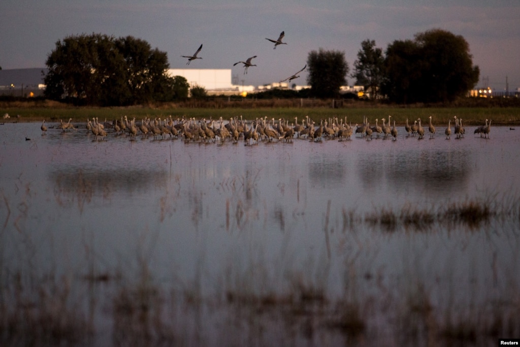
California Drought Affects Winter Refuges for Migratory Birds
Sandhill
cranes land in flooded fields at the Sandhill Crane Reserve near
Thornton, California, Nov. 3, 2015. The state's ongoing drought has left
millions of waterfowl that migrate from northern climes to California
with fewer places to land, seek food.
Reuters
November 07, 2015 10:43 AM
LODI, CALIFORNIA—With
their red heads, 2.13-meter (7-foot) wingspan and a trilling call,
migrating Sandhill Cranes provide a dramatic sunset spectacle as they
land by the thousands in wetlands near Sacramento each night during the
fall and winter.
But the state's ongoing drought has left the
cranes, along with millions of other waterfowl that migrate from Canada
and other northern climes to spend the winter in California, with fewer
places to land, threatening their health as they crowd in on one another
to seek shelter and food.
"They're left with fewer and fewer
places to go, which will start to have impacts on their population,"
said Meghan Hertel, who works on habitat issues for the Audubon Society
in California. "They can die here from starvation or disease or be
weaker for their flight back north."
Beloved sight
The cranes are a beloved sight in California's Sacramento and San Joaquin Valleys when they arrive each fall.
Tourists
flock to see them as they take off en masse at dawn or land in a series
of swooping, trilling groups as the sun goes down.
Published: 09:25 EST, 24 November 2015 | Updated: 20:28 EST, 24 November 2015
Danger list: Endangered primates that are battling for survival
They
are our closest living relatives in the animal kingdom, yet more than
half of the world's primates are facing extinction due to our
destruction of the habitats where they live.
Burning
and clearing of large areas of tropical forest, combined with hunting
of primates for food and illegal wildlife trade, has placed many species
of apes, lemurs and monkeys at risk of dying out.
These
include iconic species such as the Sumatran orang-utan, Grauer's
gorilla, the Northern brown howler monkey and the Hainan gibbon.
More
than half of the world's primates are at risk of dying out due to the
threat posed by habitat loss and hunting. The Hainan gibbon (pictured)
is thought to be the world's most endangered primate, with just 25 of
the animals left living on an isolated island in China
Scientists
and conservation experts have now updated a report on the world's 25
most endangered primates based on the current knowledge of the animals
numbers and the risks facing them.
Dr
Christoph Schwitzer, a primatologist and director of conservation at
Bristol Zoological Society who helped compile the list, said: 'This
research highlights the extent of the danger facing many of the world's
primates.
Are you getting enough minerals? A new theory suggests most of Earth’s mass extinction events
could have been caused by a lack of essential trace elements in the
world’s oceans, causing fatal deficiencies in marine animals, from
plankton to reptiles.
“It’s a complex scenario,” says John Long
from Flinders University in Adelaide, Australia. He says there are
probably a lot of causes conspiring to drive these mass extinctions. But
his latest work suggests fluctuations in essential minerals in the
ocean could be an important, and so-far completely unexplored, cause.
Essential selenium
Earlier this year, researchers discovered that periods when the ocean had high levels of trace elements – like zinc, copper, manganese and selenium
– seemed to overlap with periods of high productivity, including the
Cambrian explosion, when most groups of living animals first appeared.
Monterey Bay anchovy numbers in decline, groups say
By Samantha Clark
Santa Cruz Sentinel
Posted: 10/30/2015 12:32:04 PM PDT4 Comments | Updated: 19 days ago
Anchovies
fill a hatch aboard the El Dorado as workers unload the fishing boat at
the Moss Landing Harbor on October 16, 2015. The boat is owned by Frank
Aliotti Senior. (David Royal - Monterey Herald) ( David Royal )
Frank Aliotti Jr. moves a vacuum hose while unloadin anchovies from the El... ( David Royal )
SANTA
CRUZ -- For at least the past three years, humpback whales have been
putting on a show in the Monterey Bay. Feasting and frisking, the
40-foot-long, 40-ton leviathans create in dizzying displays.
Locals have never seen anything like it. But things have changed.
"Since
late September, the whale numbers have decreased, their behavior has
changed and their food, anchovies, are less abundant," said Nancy Black,
marine biologist and owner of Monterey Bay Whale Watch. "We were seeing
carpets just thick of anchovies for almost a mile. Now all we're seeing
is spots."
Whale watching tour companies and conservationists
claim the anchovy population has "collapsed" due to environmental
reasons so fishing limits remain too high.
Plenty of anchovies in Monterey Bay, but maybe not elsewhere
Monterey
Fish Company worker Geronimo Hernandez feeds anchovies from a chute
into iced bins while unloading the El Dorado fishing boat at the Moss
Landing Harbor on October 16, 2015. The boat is owned by Frank Aliotti
Senior. (David Royal - Monterey Herald)
A fisherman moves anchovies toward a vacuum tube inside the hatch
aboard the El Dorado as workers unload the fishing boat at the Moss
Landing Harbor on Friday. The boat is owned by Frank Aliotti Sr. David Royal — Monterey Herald
Monterey >> Things are shifting for fishermen in Monterey Bay.
Market squid are disappearing, and in their place, fishing boats are reeling in piles of anchovies.
But while they appear abundant, conservation groups warn that the forage fish may be at their lowest levels since the 1950s.
“It’s
an anomalous year,” said Diane Pleschner-Steele, executive director of
the California Wetfish Producers Association. “Typically these are not
the kind of oceanographic conditions that anchovy like. But they are
here and they’re really close to shore, which is why we’re having a
spectacular year for whale watching.”
Anchovies aren’t just bringing whales into the bay — they’re also attracting fishing fleets.
“There
are thousands of tons,” said Sal Tringali, president of Monterey Fish
Company, whose fishermen in Moss Landing are landing about 120 tons of
anchovies each night and expect to do so for about another month. “There
are all the anchovies you want out here.”
POSTED: 11:24 AM PDT Oct 21, 2015 UPDATED: 01:13 PM PDT Oct 21, 2015
Anchovy shortage in Monterey bay
MOSS LANDING, Calif. - Several conservation groups and whale watching operators are very concerned about the anchovies in the Monterey Bay.
They're
worried they're being over-fished, and want something to be done about
it. Recently, fishermen have been hauling out 120 tons of anchovies
every night, but those anchovies are some of the last along California's
coast.
Still, the groups want to make it clear they’re not
against fishermen doing their job, they’re just concerned about a lack
of data on the anchovy population and health.
Oceana’s Geoff Shester said there hasn’t been an analysis on anchovies in more than 20 years.
"The
anchovy abundance out here, and off the entire state, has gotten to
some of the lowest we've seen since the 1950s," Shester said.
"Scientists are calling it an actual collapse."
Marine Biologist
and Whale Watching Operator Nancy Black said marine animals and
fishermen are both taking from the same source, driving down the anchovy
population.
Posted: Nov 03, 2015 5:15 PM CST Updated: Nov 03, 2015 5:39 PM CST
By JJ Bailey, Online News Producer
ST. PETERS, Mo. (KMOV.com) - Residents
in St. Charles County are familiar with seeing trains. Locomotives roll
through the county several times a day, but a topic under discussion involving the Westlake Landfill has some on edge.
If
a decision is made to remove radioactive waste from Westlake, railways
could end up transporting it. A derailment is always a risk near any set
of tracks, but if train carrying radioactive waste is the one that
derails, it could be a catastrophe.
“Basically, what we want is to
have the trains run at a slower speed coming through the towns,” said
St. Peters Alderman Rock Reitmeyer. “We don't want to see any accidents
coming through our area and dropping all this waste. It could have a
hazardous effect.”
NRA to call for replacing Monju operator
Nuclear & Energy Nov. 3, 2015 - Updated 23:14 UTC-5
Japan's nuclear regulator is set to call on science minister Hirosi Hase to replace the operator of the country's prototype fast-breeder Monju reactor.
The Nuclear Regulation Authority made the decision at a meeting on Wednesday, based on its view that the current operator, the Japan Atomic Energy Agency, is unfit for the job. It says the operator of the Monju reactor in Fukui Prefecture has failed to improve its safety.
The NRA will also ask the minister to fundamentally review the reactor's status if a new operator cannot be found. It wants the minister to name an alternative operator within about 6 months.
The nuclear regulator ordered the Atomic Energy Agency 2 years ago not to conduct test-runs at Monju, after a large number of safety oversight problems surfaced.
New problems with its safety management were found even after the reactor went offline.
The NRA is authorized by law to offer unbinding recommendations to the heads of government ministries and agencies in order to ensure the safe use of nuclear power.
This is the first time the authority has decided to issue such a recommendation since it was established 3 years ago.
Tsuruga reactor to undergo screening for restart
Nuclear & EnergyNov. 4, 2015 - Updated 17:39 UTC-5
The operator of the Tsuruga nuclear power plant in central Japan is to apply for screening of one of its reactors to put it back online.
The Nuclear Regulation Authority concluded in its assessment in March that the No.2 reactor on the Sea of Japan Coast in Fukui Prefecture stands directly above a fault, and could move in the future.
The unit may be forced to shut down permanently.
Japan adopted tougher regulations that ban construction of reactor buildings and other key structures above such faults after the 2011 Fukushima Daiichi nuclear disaster.
The Japan Atomic Power Company says it challenges the assessment of the nuclear regulator, and will apply for a safety screening on Thursday.
The screening is a prerequisite in resuming operations of reactors that remain offline following the nuclear disaster. The operator compiled reports on its new findings after carrying out fresh drilling surveys and other on-site studies.
It argues it found that the fault that the nuclear regulator has concluded may shift in the future has not been active for many years, and said that the fault will remain inactive in the future.
Possible violation in radioactive waste storage
Nuclear & Energy Nov. 2, 2015 - Updated 06:15 UTC-5
Japan's Nuclear Regulation Authority secretariat has found the operator of a uranium enrichment plant in Aomori Prefecture stored radioactive waste in a location that violated safety regulations. The plant enriches uranium for nuclear power generation.
The Secretariat of the NRA is expected to ask Japan Nuclear Fuel Limited to remedy the situation.
The secretariat says the violation was discovered in August during an inspection of the plant in northeastern Japan.
It says the operator has been storing low-level radioactive waste temporarily in a room near equipment used to produce enriched uranium. The secretariat says the location is in violation of safety regulations.
The operator later moves the waste to a location that meets safety regulations.
But the secretariat says the temporary storage place is in violation of regulations. It is expected to ask the operator to correct the situation.
Officials at Japan Nuclear Fuel Limited say the plant made its own rules for temporary storage. They say there have been no leaks of radioactive substances.
The officials say they will store the waste in a proper way in the future.
The
new Old World Drought Atlas of droughts and wet weather in the Old
World gives climate scientists greater perspective on current weather
phenomenon.
Climate
scientists have produced an atlas reconstructing weather conditions
over the last millennium, in an effort to understand more about current
changes to the weather.
They hope their Old World Drought Atlas (OWDA) will allow for a greater understanding of climate forecasts.
"Climate
model projections suggest widespread drying in the Mediterranean Basin
and wetting in Fennoscandia in the coming decades largely as a
consequence of greenhouse gas forcing of climate," write the scientists
in their paper, published in Science Advances on Friday.
The
researchers used archaeological tree ring data to measure more than a
thousand years of European weather. They compared their findings
to historical accounts of severe droughts, wet weather events or other
catastrophes, and found that the tree ring data corresponds with many
documented incidents of extreme weather.
Oh,
and look at 1741, and the terrible drought. The trees are showing the
results of the cold and dry spell that began in 1739. This is the year
of the great Irish famine, and it killed millions as well. Here’s what
the paper has to say about the 1741 map:
The Irish famine of
1740–1741: This event has been attributed to unusually low winter and
spring temperatures in 1740, resulting in crop failures and subsequent
famine (17).
The OWDA is not well suited for determining temperature anomalies
because it primarily reflects warm season
hydroclimate. However, climate
field reconstructions of seasonal precipitation from documentary and
early instrumental data (18)
indicate that spring-summer rainfall over Ireland in 1741 was well
below normal relative to the modern average. Drought over Ireland may
therefore have contributed to the severity of the famine through its
negative impact on food production in 1741. The OWDA map of 1741
indicates severe drought over Ireland that also extended over England
and Wales, consistent with previously reported record rainfall deficits.
Is
it just me, or does this give you the willies? It’s like looking at
that big high pressure over the NW Atlantic on the night of April
14,1912. The Titanic survivors reported the ocean as still as a
mill-pond, and I have the surface weather map that proves they were
right. That’s how I feel about these rainfall charts. That horrible
famine was seven long centuries ago, but the trees still remember, and
they tell us that those old faded pieces of parchment were not
exaggerating. It was real, and it left millions dead, and millions more
in grief.
This Old World Drought Atlas will have great
benefits in climate research, and historians will find them invaluable
as well, but they also give us a warning. Our limited 100 years or so of
written weather records can be deceiving. We think we know what a bad
crop year is, and how long a bad drought can last, but our lifetimes are
rather short, and perhaps we are fools. Knowing this makes fooling with
our planet’s temperature control even more egregious.
The paper is open access and you can read it all HERE.
Monday, November 02, 2015 by: L.J. Devon, Staff Writer
(NaturalNews)
A five-year fire is burning beneath a landfill in a St. Louis suburb,
and it's rapidly approaching an old cache of nuclear waste.
At
present, St. Louis County emergency officials are unsure whether or not
the fire will set off a reaction that releases a radioactive plume over
the city. An emergency plan was put together in October 2014 to "save
lives in the event of a catastrophic event at the West Lake Landfill."
St.
Louis County officials warn, "There is a potential for radioactive
fallout to be released in the smoke plume and spread throughout the
region."
Many residents are taking precautions; some are buying
gas masks, while others are considering moving away. Just recently, over
500 local residents discussed the precarious situation at a church
meeting which usually draws in less than 50 people.
EPA not worried about the fire or the nuclear waste
Nothing
stands in the way of the uncontrollable landfill fire, which is
smoldering hot underneath the trash of the West Lake Landfill of
Bridgeton County, St. Louis. This "smoldering event" is not uncommon.
Fires ignite and smolder under landfills because the trash becomes so
compact and hot. In this case, the fire is brewing less than a quarter
mile from an old deposit of nuclear waste that threatens to spread
cancer-causing radon gas.
EPA
officials admit that although the waste may eventually emit radon gas,
it won't affect anything outside the landfill property. This is the same
EPA that polluted the Colorado River with 3 million gallons of toxic
sludge full of lead, arsenic and other heavy metals. EPA
contractors breached a mine, sending the sludge flowing into the Animas
river, which quickly turned putrid and murky. That pollution has now
spread to New Mexico, Utah and Arizona, infiltrating the countryside
with toxic elements. Why should anyone in St. Louis County trust the EPA with radioactive waste?
To
make matters worse, the EPA isn't even worried about the fire reaching
the nuclear waste. "We just do not agree with the finding that the
subsurface smoldering event is approaching the radiologically impacted
material," said Mary Peterson, director of the Superfund division for
EPA Region 7.
There have been no plans to remove the radioactive
waste as of yet, leaving local residents baffled and worried. Most
residents were unaware of the existence of the radioactive waste, which
had been dumped there illegally four decades ago. If it weren't for
activists educating the public about the waste, no one would know.
Radioactive waste comes back to haunt St. Louis
The
radioactive waste includes 8,700 tons of leached barium sulfate
residue. It was illegally dumped in the West Lake Landfill by Cotter
Corporation sometime after World War II and wasn't discovered by
investigators until 1973. The radioactive waste was left behind due to
the mishandling of uranium by Mallinckrodt Chemical Works, a company
that started out working for the federal government's Manhattan Project.
Since 1990, the West Lake Landfill
has been managed by the EPA and deemed a Superfund site. The U.S.
Department of Health and Human Services Agency for Toxic Substances and
Disease Registry recently warned all agencies not to disturb the surface
of the landfill.
They warned that radium-226, radon-222 and radium-228 could be released
into the air, putting people near the landfill at risk.
The
agency reported that radon levels in the area are often measured above
regulations "by as much as 10 to 25 times at individual surface test
locations." Moreover, radium increases people's risk of developing bone,
liver and breast cancer.
The EPA is downplaying the potential for a Chernobyl or Fukushima-like disaster,
but residents have every reason not to trust the agency's guesswork,
given its decades-long refusal to safely remove the radioactive material
from the area.
The
NaturalNews Network is a non-profit collection of public education
websites covering topics that empower individuals to make positive
changes in their health, environmental sensitivity, consumer choices and
informed skepticism. The NaturalNews Network is owned and operated by
Truth Publishing International, Ltd., a Taiwan corporation. It is not
recognized as a 501(c)3 non-profit in the United States, but it
operates without a profit incentive, and its key writer, Mike Adams,
receives absolutely no payment for his time, articles or books other
than reimbursement for items purchased in order to conduct product
reviews.
The vast majority of our content is freely given away at
no charge. We offer thousands of articles and dozens of downloadable
reports and guides (like the Honest Food Guide)
that are designed to educate and empower individuals, families and
communities so that they may experience improved health, awareness and
life fulfillment.
Tonya
Mason, who works just feet away from the fence line of Republic
Services' landfill in Bridgeton, expresses anger that the air from
burning underground material has never been tested for contaminants on
Thursday, Oct. 15, 2015 at a meeting by Just Moms at John Calvin
Presbyterian Church. Hundreds of people gathered to hear about the
ongoing problems at the site. Photo by Christian Gooden,
cgooden@post-dispatch.com
More
than 40 years ago, radioactive waste was dumped at the West Lake
Landfill in Bridgeton. The decades since have been filled with legal and
political moves that have not gotten the site cleaned up.
Now
a growing number of residents want to know how dangerous it is to live
and work in the area as a fire burns underground in the adjoining
Bridgeton Landfill. More than 500 people showed up at a Bridgeton church
on Thursday for a meeting organized by residents. The monthly meetings
held for the last two years typically attract no more than 50.
The
surge in public interest comes after state reports showed the fire is
moving toward the nuclear waste, and radioactive materials can be found
in soil, groundwater and trees outside the perimeter of the landfill.
At
least six school districts have sent letters home in the last week
outlining their plans for a potential nuclear emergency. St. Louis
County recently released its own emergency evacuation plan that was
written last year.
Underground fires are common in
landfills as buried garbage can get hot, much like the bottom of a
compost pile. Typically they are monitored and allowed to burn out. But
none of the fires have gotten so close to nuclear waste, which was
created during the World War II era for St. Louis’ part in the
production of the atomic bomb.


 and Erik Conway attend the 'Merchants of Doubt' premiere during the 2014 Toronto International Film Festival.")

![This graph, based on the comparison of atmospheric samples contained in ice cores and more recent direct measurements, provides evidence that atmospheric CO2 has increased since the Industrial Revolution. (Source: [[LINK||http://www.ncdc.noaa.gov/paleo/icecore/||NOAA]])](https://lh3.googleusercontent.com/blogger_img_proxy/AEn0k_vXNcIMRnx4q_ooRk3FLTVyHei7cuPioYpsfADjNyjX7_PMa8XoFI7Bt4HqNtbGcjelS_saYoCiwj9yt3wzedRl7Z4VrXn99fWCAV_UL1lxOzOrVqzmi9G16g5d7nxNAGdjW_tDhfCQw3KfpTRmvCTB5fUC=s0-d)