Global Weather Phenomenon-Natural/Technological Disasters-Space Events-Epidemic/Biological Hazards-
Nuclear Events :
News Affiliate of Family Survival Protocol.com
Published: 22:18 EST, 19 December 2015 | Updated: 03:17 EST, 20 December 2015
For the second time in two months, a rare deadly sea snake has washed ashore at one of southern California's most popular beaches.
A dead 27-inch-long male yellow bellied sea snake was discovered last week during a coastal cleanup campaign by volunteers for the Surfrider Foundation in Huntington Beach, the Los Angeles Times reported.
In October, a two-foot-long yellow bellied sea snake was discovered slithering onto Silver Strand State Beach in Ventura County, but it died shortly after being taken to a US Fish and Wildlife Service office nearby.
The venomous sea serpent, known to scientists as Pelamis platura, was first spotted in 1972 during an El Niño in San Clemente.
Deadly: A dead 27-inch-long male yellow bellied sea snake (above) was discovered last week during a coastal cleanup campaign by the Surfrider Foundation
The latest yellow bellied sea snake discovered was found at the popular Huntington Beach in California (file photo above)
A descendant of Australian tiger snakes, experts believe the arrival of the sea snake is a harbinger of El Niño because the last time it appeared in California was during the weather system in the '80s.
The annual Geminid meteor shower peaks tonight, Dec. 13-14, as Earth passes through a stream of gravelly debris from "rock comet"
3200 Phaethon. Dark-sky observers in both hemispheres could see as many
as 120 meteors per hour during the dark hours between midnight and
sunrise on Dec. 14th. Last night, Dec. 12-13, NASA's all-sky meteor
network detected 15 Geminid fireballs over the USA. That number will
surely grow on peak night--tonight! Got clouds? Listen for Geminid
echoes in the audio feed from our live meteor radar.
Geminids meteor shower prediction: Moonless and marvelous
By Alan MacRobert
Updated 3:12 PM ET, Sat December 12, 2015
Story highlights
Geminids meteor shower is peaking
Geminid meteors can flash into view anywhere in the night sky
(Sky and Telescope)The nights of December 13-14 offer dark skies for a popular, underappreciated meteor display.
The
Geminid meteor shower competes with August's Perseids for showiness —
yet it's not nearly as well-known. The Geminids are easier on your sleep
schedule, too. Their radiant (near Castor in Gemini) climbs as high by
11 p.m. standard time (45 degrees above the local horizon) as the
Perseid radiant does by 2 a.m. daylight time on the peak Perseid nights.
The higher the radiant, the more meteors you'll see.
The
Geminid meteors can flash into view anywhere in the late-night sky when
the shower peaks in mid-December. But if you follow their paths back
far enough, they all appear to diverge from a point in the constellation
Gemini.
The
International Meteor Organization (IMO) predicts that the Geminids
should reach an impressive zenithal hourly rate of 120 this year. (ZHR
is how many meteors you'd see see per hour in a very dark sky if the
radiant were at the zenith. This year the peak should be centered on
roughly 18h Universal Time on December 14. Unfortunately, that's 1 p.m.
EST and 10 a.m. PST. So in North America the shower's performance is
likely to be similar on the nights of December 13-14 and 14-15.
As
the IMO notes, "Near-peak Geminid rates persist for almost a day, so
much of the world has a chance to enjoy something of the shower's best."
In addition, "mass-sorting within the stream means fainter telescopic
meteors should be most abundant almost a day ahead of the visual
maximum," and the meteors after maximum are typically brighter than
average.
The moon will be a waxing crescent a few days old, no trouble at all.
A
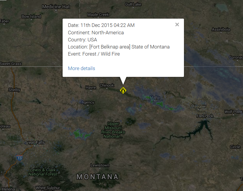
large grass fire is burning several miles east of Fort Belknap. There
are no reports of injuries at this time; the cause of the fire is not
yet known. Randy Perez tells us that the fire is heading toward Pony
Hill Cemetery, and is south of Savoy Road. Perez, who lives very close
to where the fire is burning, says that it is burning in mostly
grass-land, with some alfalfa. He tells us that the wind pushed the fire
toward Savoy Road, and the fire then changed direction. Hundreds of
tons of hay have burned; at this point, no livestock are believed to
have perished. The fire is believed to be about nine miles long, and
more than a mile wide. Perez says that ranches have moved two herd of
cattle and 100 bulls from the area to escape the approaching flames. At
least ten fire trucks are at the scene, with crews responding from the
MT Department of Natural Resources and Conservation, Harlem, Turner,
Chinook, Dodson, Malta, and Fort Belknap. Authorities estimate that the
fire has burned about 5,000 acres.
Fires Continue to Burn on Kootenai National Forest
Fires in Lincoln County continue to burn and send smoke to the Flathead Valley
By Beacon Staff // Sep 30, 2015 //
Unseasonably
dry and warm fall weather has allowed the lightning-caused fires in the
Goat Rock complex and Marston Fire to continue to burn and send smoke
to the Flathead Valley.The fires in the Goat Rock complex have burned
more than 22,000 acres and are located in and around the Cabinet
Mountains Wilderness and Scotchman Peaks area. The Marston Fire has
burned over 7,000 acres north of Trego.
While some of the fires
are continuing to grow slowly, the majority of the burning is in the
interior with pockets of fuel burning within the perimeter of the fires,
fire managers say. These fires will continue to burn and put up smoke
until the area receives significant rain and or snow. Read More Here
...........
Speaking at a United Nations “climate” summit in Paris, Obama blamed America for alleged man-made global warming and claimed that the nation embraces its responsibility to “do something” about the alleged problem. That “something,” of course, at least in the administration's view, involves redistributing the wealth of embattled U.S. taxpayers to Third World governments and dictatorships for climate reparations, as well as shackling the American economy with draconian controls to reduce emissions of what serious scientists know as the “gas of life.” Sounding like a wannabe messiah, Obama even claimed that “we finally determined we would save our planet.” However, lawmakers in Congress and the American people have made clear that they neither believe in the increasingly discredited anthropogenic global-warming (AGW) theory nor in the alleged solutions to the supposed problem.
Dictators and other heads of state have typically arrived at UN conferences toward the end of the show. This time, however, hoping desperately to secure a global “climate” agreement where past summits have failed, UN organizers decided Obama and other “world leaders” should show up at the start. Obama complied, spewing gargantuan amounts of CO2 and arriving in Paris to deliver various speeches hyping the AGW theory, along with illegal pledges to hand out your money. “I've come here personally, as the leader of the world's largest economy and the second-largest emitter, to say that the United States of America not only recognizes our role in creating this problem, we embrace our responsibility to do something about it,” Obama claimed at the ongoing conference, which featured some 150 dictators and heads of government and state.
Of course, Obama is not the “leader” of the “world's largest economy.” His job description is to serve as the chief executive of the federal government, to faithfully execute the laws, and to uphold and defend the Constitution. His other claims were even more ludicrous. For instance, the notion that America recognizes its alleged role in creating the alleged problem could not be more wrong. According to a Pew survey released last year, just 40 percent of Americans even believe the increasingly discredited AGW theory. And without a doubt, far less than that would agree that the nation should shackle its economy and redistribute its wealth to Third World regimes under the guise of dealing with a problem that the overwhelming majority of Americans do not even believe exists.
Obama blames America for non-existent global warming
Barack Obama speaks at U.N. climate summit.
Saul Loeb/AFP/Getty Images
While speaking at the United Nations on Tuesday, President Obama blamed the United States for global warming, even though there has been no global warming for nearly 18 years. While the administration insists global warming is a real threat, one professor issued a paper saying there has been no global warming for 19 years.
"But there should be no question that the United States of America is stepping up to the plate," Obama said. "We recognize our role in creating this problem; we embrace our responsibility to combat it. We will do our part, and we will help developing nations do theirs. But we can only succeed in combating climate change if we are joined in this effort by every nation –- developed and developing alike. Nobody gets a pass."
Obama hyped action the United States has taken, touting moves taken against power companies in what has been described as a "war on coal." According to the president, the United States has reduced its total "carbon pollution" by more than any other nation.
Carolyn is a staff writer for Science and is the editor of the In Brief section.
..........
It’s getting hot in here. A dispute between the chairman of the U.S. House of Representatives Committee on Science, Space, and Technology and the National Oceanic and Atmospheric Administration (NOAA) over a climate change paper published this summer is escalating. The latest salvos include a second letter from Representative Lamar Smith (R–TX) to NOAA Administrator Kathryn Sullivan seeking internal communications and documents authored by NOAA employees and a letter from the American Meteorological Society condemning Smith’s demands and warning about its implications for all federally funded research.
The quarrel began with a paper by NOAA scientists published 5 June in Science that revised historical atmosphere and ocean temperature data records found to have been poorly calibrated. In 2013 the Intergovernmental Panel on Climate Change had noted that the temperature data seemed to suggest that global warming had slowed down beginning around 1998. But the Science paper showed that apparent slowdown in global warming vanished when the data were corrected to account for various sources of bias.
That paper immediately caught Smith’s attention, triggering multiple committee requests for data and methodologies related to the study. NOAA told the committee that the findings were already publicly available and met twice with committee staff to brief them on the results.
But that response didn’t satisfy Smith. On 13 October, he subpoenaed all of NOAA’s internal emails related to the paper, asking for the information by 27 October. In response, the committee’s Democrats wrote to Smith on 23 October, noting that the subpoena “appears to be furthering a fishing expedition” and saying that it oversteps the committee’s bounds, as the paper is a research study and not a policy decision. House Republican leadership this year had given Smith the authority to issue subpoenas without the consent of the minority party.
Did Federal Agency Commit Climate Fraud? Sure Looks Like It
10/28/2015 06:30 PM ET
Junk Science: Worried about climate fraud, Congress is investigating a federal agency for allegedly manipulating weather data to show recent global warming when there is none. So why is the agency refusing to cooperate?
First, a little background: Satellite temperature readings clearly show no warming trend for the last 18 years, 8 months and counting. None.
This fact is significant for two reasons: One, satellite temperature readings are the most comprehensive and thus the most accurate. And, two, the pause in warming since 1998 undercuts the entire global warming agenda of the environmental movement and its allies on the left who see in climate change an opportunity to impose greater government control over our lives.
Yes, we're skeptical of "climate change," at least as defined by the green extremists. Climate is always changing. No one denies that. What's at issue is how it's changing and why. The science is still unclear.
Earlier this year, National Oceanic and Atmospheric Administration (NOAA) scientists took part in a study that found — no surprise — that the "pause" in global warming from 1998 to 2013 didn't exist.
Their change didn't come from actual temperature readings. It came from extensive data manipulation and tinkering. Instead of a pause, they found a surge.
The National Oceanic and Atmospheric Administration is refusing to hand over its climate scientists' emails to Rep. Lamar Smith.
See more at http://www.newsy.com/
Here’s another reason to stay in New York this holiday season — the “kissing bug” has now spread to 28 states.
Texas
is the latest to report an outbreak of infections from the Latin
American triatomine bug after the pest had been spotted in other
southern and western states, including Georgia, Alabama and California,
according to the Centers for Disease Control and Prevention.
The
creepy crawler resembling a cockroach gets its colorful nickname
because it likes to bite around the lips and eyes of people when they
are asleep. More than half of the bugs carry a parasite that can cause
Chagas disease in humans, dogs and other mammals.
The good news?
To actually pass on the disease, the bug not only needs to bite you, but
then defecate into the gash. If left untreated, up to 30% of bite
victims will develop chronic conditions such as difficulty breathing,
heart and intestinal complications, and, in extreme cases, death.
There
have been eight million cases in Latin America and South America
because of poorly constructed rural homes, according to the CDC.
To prevent an outbreak, the CDC recommends:
Sealing cracks and gaps around windows, walls, roofs, and doors.
Removing wood, brush, and rock piles near your house.
If
you've been paying attention to the weather news at all lately, you'll
know that it's a big year for a weather event called El Niño.
The
complex phenomenon could bring warmer, wetter weather to the Northeast
this winter and much-needed rain to California, but worsen cold and
drought conditions elsewhere in the US.
And this year's El Niño could be one of the most powerful on record, experts say.
"One
of the strongest El Niño events in the past 65 years is likely to bring
significant winter weather to the United States," James Aman, senior
meteorologist at Earth Networks, said in a statement.
What the heck is El Niño, anyway?
El
Niño is a weather event characterized by warmer-than-normal
temperatures in the equatorial Pacific Ocean, with important
consequences for global weather and climate, according to the National Oceanic and Atmospheric Administration. By contrast, La Niña refers to colder-than-normal Pacific temperatures.
The
effects of El Niño can be seen across the globe, from increased
rainfall in the Southern US and Peru to drought in the Western Pacific
and brush fires in Australia.
Tropical
Storm Kate is strengthening as it moves away from the Bahamas. This
trend is expected to continue due to warm sea surface temperatures and
low vertical wind shear.
Kate is not a direct threat to the United States.
(MORE: Follow Tropical Storm Kate With Our Interactive Storm Tracker) Highlights:
Tropical Storm Kate was centered 175 miles north-northeast of the northwestern Bahamas as of Monday night.
All tropical storm warnings have been discontinued.
The threat of heavy rain and gusty winds in the Bahamas are diminishing.
High surf will continue to impact eastward-facing beaches in the northwestern Bahamas.
Tropical Storm Kate is not expected to make landfall in the U.S.
The
latest forecast calls for Kate to become a strong tropical storm and
possibly a hurricane before eventually being absorbed by a non-tropical
low pressure system midweek as it moves out to sea.
Kate is the eleventh named storm of the 2015 Atlantic hurricane season.
Kate originally formed as Tropical Depression Twelve Sunday night, and was upgraded to tropical storm status Monday morning.
Tropical
Storm Kate formed Monday morning in the Atlantic Ocean near the
Bahamas, the National Hurricane Center said. It is unlikely to directly
impact the U.S.
As of 1 p.m. ET, the storm had maximum sustained
winds of 45 mph and was located 30 miles east-southeast of
Eleuthera Island in the Bahamas. Kate was moving to the northwest at 15
mph.
Rain squalls accompanying Kate will graze the eastern islands
of the Bahamas into Monday night, AccuWeather said. Tropical storm
warnings have been hoisted for portions of the central and western
Bahamas, the hurricane center reported.
The American Dream Is Becoming A Nightmare And Life As We Know It Is About To Change
By Michael Snyder, on November 1st, 2015
More
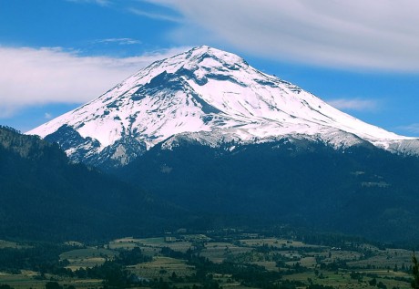
than 25 million people live in the vicinity of North America’s
2nd-highest volcano, and in recent weeks this volcano has been steadily
rumbling and has been spewing out massive amounts of black smoke and
ash. I have previously written about “the most dangerous mountain in
the United States” (Mt. Rainier),
but if the volcano that I am talking about today experiences a
full-blown explosive eruption it could potentially be a cataclysmic
event beyond what most of us would dare to imagine. Popocatepetl is an
Aztec word that means “smoking mountain”, and it is also the name of a
giant volcano that sits approximately 50 miles away from Mexico City’s
18 million residents.
“Popo”, as it is called by locals, was dormant
for much of the 20th century, but it came back to life in 1994. And now
all of this unusual activity in recent weeks has many wondering if a
major eruption may be imminent.
Historians tell us that
Popocatepetl had a dramatic impact on the ancient Aztecs. Giant mud
flows produced by massive eruptions covered entire Aztec cities. In
fact, some of these mud flows were so large that they buried entire pyramids in super-heated mud.
But
we haven’t witnessed anything like that in any of our lifetimes, so it
is hard to even imagine devastation of that magnitude.
In addition
to Mexico City’s mammoth population, there are millions of others that
live in the surrounding region. Overall, there are about 25 million
people that live in the immediate vicinity of Popocatepetl. Thankfully,
we haven’t seen a major eruption of the volcano in modern times, but at
some point that will change.
As most of you already know, Mexico
sits on the “Ring of Fire” that stretches along the outer rim of the
Pacific Ocean. Over the past couple of years seismic activity
throughout this area has started to really heat up, and according to Volcano Discovery there are dozens of volcanoes associated with the Ring of Fire that have recently erupted.
Over
10 million people in the south-central U.S. face potential flash
flooding as a slow-moving storm dumps heavy rain through the weekend —
and only intensifies in the wake of Hurricane Patricia, forecasters
warn.
Cars were reportedly stranded by floodwaters in Corsicana,
south of Dallas, after nearly 10 inches of rain fell by Friday afternoon
since midnight, the National Weather Service said.
Officials in
Galveston County were considering a voluntary evacuation of Bolivar
Peninsula but would reevaluate Saturday morning.
Much of central
and southeast Texas were under a flood watch Friday and there were flash
flood warnings issued for Navarro and Hamilton counties, according to
the National Weather Service.
Over 4 inches of rain fell on
Collins by Friday afternoon and more than 6 inches of rain fell over 48
hours in parts of Tarrant County by Friday afternoon, the NWS said.
Water
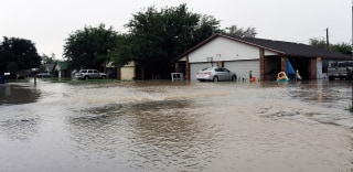
flows into a neighborhood Thursday, Oct. 22, 2015, in Midland County,
Texas following heavy rains overnight. One home owner said he had water
in his garage and his neighbor had water in his house. Mark Sterkel / Odessa American via APIn
total, parts of Texas could see 3 to 6 inches — and upwards of 10
inches locally — through Sunday, aid Lamont Bain, a meteorologist in the
National Weather Service's Fort Worth office, said.
That's because Patricia, the strongest storm ever measured on
the planet, is expected to make landfall along Mexico's Pacific coast
Friday night before pushing north into the United States.
Hundreds
of dead fish were found in two south Clear Lake locations in early
October. Pictured is one in Baylis Cove. Photo provided by Terry Knight,
taken by resident Jon Braden.
..........
Biological Hazard
USA
State of California, [Clear Lake]
..........
Biological Hazard in USA on Wednesday, 14 October, 2015 at 11:47 (11:47 AM) UTC.
Description
Fish
die-offs are not uncommon in Clear Lake. Sometimes fish suffocate when
oxygen-depleting algal blooms explode. Other times, koi herpes virus
attacks carp, causing their carcasses to litter the shoreline. But two
early October incidents, about 3 miles apart at the south end of the
lake, are believed to have been caused by a less natural killer,
capturing the attention of state Fish and Wildlife officials. "It's
under investigation," said Fish and Wildlife spokesman Steve Gonzalez.
He did not divulge any other information. Environmental scientists
working for area tribes suspect a chemical spill, possibly petroleum
based, killed the fish, estimated in the hundreds. Witnesses reported a
chemical odor and oily sheen on the water, said Sarah Ryan,
environmental director for the Big Valley Rancheria. Clear Lake tribes'
environmental agencies work closely with state and local government
agencies in monitoring the health of the lake, she said. "We sent (water
samples) to a local lab for analysis" of petroleum components, she
said. "We're thinking it's some sort of chemical spill." The results of
the tests are expected later this week, she said. Carcasses of some of
the dead fish were sent to Fish and Wildlife officials, who are
conducting their own analysis, Ryan said. Two otters reportedly also
were found dead in the area but the person who discovered them disposed
of the carcasses, so they have not been verified or examined, Ryan said.
Besides the oily sheen and odor, there are a number of other reasons to
suspect a toxic spill or release into the lake. Ryan said her
counterpart who works for the Elem Pomo tribe conducted tests at one
location on Oct. 2, the day the dead fish were reported. She found that
oxygen levels were more than adequate to sustain fish. "The oxygen level
was fine," Ryan said. There also were many different species and ages
of fish killed. Normally, larger fish simply swim away from
oxygen-depleted or fouled areas, so mostly smaller, shore-hugging fish
are found dead. That wasn't the case with the recent incident.
"Something overwhelmed them very quickly," said Greg Giusti, a UC
Extension ecologist who has studied the lake for 20 years. He said he
has received multiple phone calls about the event. "I'm of the opinion
it was some kind of pollutant," Giusti said. Lake County resident Terry
Knight, an environmental and outdoor writer who has been keeping close
tabs on Clear Lake for 28 years, said he has never seen an event that
affected so many species in such a short time. There have been no
additional reports of dead fish since then, he said. "It was not a
normal die-off," he said. Fish and Wildlife officials suspect something
was dumped into storm drains, which empty into the lake, Giusti said.
Ryan said it could be a fuel spill, possibly from a fueling dock, or
chemicals dumped into storm drains. Some people are careless about
fueling their boats, allowing gasoline to spill into the water, she
said. Others seem unaware that anything dumped into a storm drain will
end up in the lake. Everyone involved in the case has their suspicions
of what caused the fish to die, but no one will know for sure unless
tests produce revelations.
Biohazard name:
Mass die-off (fishes)
Biohazard level:
2/4 Medium
Biohazard desc.:
Bacteria and viruses that cause only mild disease to humans, or are difficult to contract via aerosol in a lab setting, such as hepatitis A, B, and C, influenza A, Lyme disease, salmonella, mumps, measles, scrapie, dengue fever, and HIV.
"Routine diagnostic work with clinical specimens can be done safely at
Biosafety Level 2, using Biosafety Level 2 practices and procedures.
Research work (including co-cultivation, virus replication studies, or
manipulations involving concentrated virus) can be done in a BSL-2 (P2)
facility, using BSL-3 practices and procedures. Virus production
activities, including virus concentrations, require a BSL-3 (P3)
facility and use of BSL-3 practices and procedures", see Recommended
Biosafety Levels for Infectious Agents.
Symptoms:
Status:
suspected
..........
Mystery fish deaths in Clear Lake trigger investigations
Hundreds
of dead fish were found in two south Clear Lake locations in early
October. Pictured is one in Baylis Cove. Photo provided by Terry Knight,
taken by resident Jon Braden.
Fish
die-offs are not uncommon in Clear Lake. Sometimes fish suffocate when
oxygen-depleting algal blooms explode. Other times, koi herpes virus
attacks carp, causing their carcasses to litter the shoreline.
But
two early October incidents, about 3 miles apart at the south end of
the lake, are believed to have been caused by a less natural killer,
capturing the attention of state Fish and Wildlife officials.
“It’s under investigation,” said Fish and Wildlife spokesman Steve Gonzalez. He did not divulge any other information.
Environmental
scientists working for area tribes suspect a chemical spill, possibly
petroleum based, killed the fish, estimated in the hundreds. Witnesses
reported a chemical odor and oily sheen on the water, said Sarah Ryan,
environmental director for the Big Valley Rancheria. Clear Lake tribes’
environmental agencies work closely with state and local government
agencies in monitoring the health of the lake, she said.
“We
sent (water samples) to a local lab for analysis” of petroleum
components, she said. “We’re thinking it’s some sort of chemical spill.”
The results of the tests are expected later this week, she said.
Carcasses
of some of the dead fish were sent to Fish and Wildlife officials, who
are conducting their own analysis, Ryan said. Two otters reportedly also
were found dead in the area but the person who discovered them disposed
of the carcasses, so they have not been verified or examined, Ryan
said.
An
out-of-control brush fire at Camp Pendleton was creeping closer to the
San Onofre nuclear power plant, prompting evacuations. Southern
California Edison said in a tweet that "about a dozen non-essential
employees evacuated" from the plant because of the fire. The plant is
located off Interstate 5 at the Orange-San Diego county line north of
Camp Pendleton. Edison announced last year it was closing the plant due
to structural problems with facility. The Camp Pendleton fire was
spotted shortly before 10 a.m. Wednesday and forced evacuations of the
De Luz housing area, Mary Fay Pendleton Elementary School and the Naval
Weapons Station Fallbrook, which is on the northeast edge of the
sprawling base. A second school and housing area have been evacuated as
the brush fire at Camp Pendleton continues to spread. The fire, dubbed
the Tomahawk fire, on the northeast section of the base, had burned more
than 150 acres as of 1 p.m., according to Cal Fire. An evacuation
center was established at the Paige Fieldhouse on the base. The
Pendleton fire was one of several blazes burning in San Diego County.
One in Carlsbad has burned homes. More than 11,500 evacuation notices
have been issued for the fire as it moves through neighborhoods amid
steep brushy canyons.
Fire forces evacuation of San Onofre nuclear plant
An out-of-control brush fire at Camp Pendleton was creeping closer to the San Onofre nuclear power plant, prompting evacuations.
Southern
California Edison said in a tweet that "about a dozen non-essential
employees evacuated" from the plant because of the fire.
The plant
is located off Interstate 5 at the Orange-San Diego county line north
of Camp Pendleton. Edison announced last year it was closing the plant
due to structural problems with facility.
The
Camp Pendleton fire was spotted shortly before 10 a.m. Wednesday and
forced evacuations of the De Luz housing area, Mary Fay Pendleton
Elementary School and the Naval Weapons Station Fallbrook, which is on
the northeast edge of the sprawling base.
CAMP
PENDLETON, Calif. — Firefighters continued making progress Sunday
containing three fires that have blackened 21,900 acres on Camp
Pendleton and Naval Weapons Station Fallbrook.
The largest of the
fires, the fast-moving Las Pulgas Fire, had burned about 15,000 acres
since it erupted for unknown reasons at about 3:15 p.m. on Thursday near
a sewage plant in Camp Las Pulgas. The blaze was 75 percent contained
Sunday afternoon, according to officials.
The
first fire reported, the so-called Tomahawk Fire, broke out at Naval
Weapons Station Fallbrook at the eastern outskirts of Camp Pendleton at
about 9:45 a.m. on Wednesday and later spread to the Marine base. It was
100 percent contained Sunday and had blackened about 5,400 acres.
The
most recent blaze to break out at Camp Pendleton, dubbed the San Mateo
Fire, began spreading just before 11:30 a.m. on Friday near Basilone
Road. It had grown to about 1,500 acres today and was 97 percent
contained, according to base officials.
Gen. James F. Amos, the
Commandant of the Marine Corps, and Brig. Gen. John W. Bullard, the
Marine Corps Installations West commanding general, were briefed today
on the three fires — known collectively as the Basilone Complex – - at
Camp Pendleton. Amos and Sgt. Maj. Michael P. Barrett, sergeant major of
the Marine Corps, also spoke with firefighters working to extinguish
the blazes.