Showing posts with label National Weather Service. Show all posts

Wednesday, December 9, 2015

Portland, Oregon - Floods, landslides, road closures and even a sinkhole brought about by storm and the next wave of heavy rains is expected by tuesday.


KREM

Wettest day in Portland history causes landslides, floods

PORTLAND, Ore. -- Monday was the wettest calendar day in recorded history in Portland, and the rain is expected to stick around for days.

KGW meteorologist Matt Zaffino said nearly 2.7 inches of rain on Monday tied a record for one day, from 12:01 a.m. to 12:00 a.m. The previous record was set on Nov. 19, 1996. More rain is forecast for Monday night, and Zaffino said the record is sure to break.

The storm that caused floods, landslides, road closures and even a sinkhole is expected to bring its next wave of heavy rain on Tuesday, possibly during the evening commute.
People should expect delays in every mode of transportation in the metro area for the next several days, according to the Portland Bureau of Transportation.

Authorities were offering sand bags to any area residents who need them.

At a news conference Monday afternoon, Portland Bureau of Transportation spokesman Dylan Rivera called the weather an "extraordinary event that had extraordinary impacts."
Rivera said 5.61 inches of rain have fallen so far this month, with three inches falling within a 12-hour period.

The December average for rainfall in the metro area is 5.49 inches.
KGW Meteorologist Rod Hill said said the worst of the storm has not even hit yet.  That will likely happen on Tuesday night and continue into Thursday.


Read More Here

Sunday, November 29, 2015

Flooding and wintry precipitation have led to at least 10 deaths in Texas and Kansas as a storm system moves across the central Plains


  •  
    By Slma Shelbayah and Kimberly Hutcherson CNN

    10 dead as wintry storm hits Plains

    Millions under winter weather, flood warnings

    UPDATED 4:59 PM CST Nov 29, 2015
    OK ice storm 11.29.15
    CNN KOCO
     
    (CNN) —The governor of Oklahoma, Mary Fallin, has declared a state of emergency for her state, according to KOCO.
This follows an ice storm and flooding that has knocked out power for thousands of people throughout the state.

Meanhwhile, flooding and wintry precipitation have led to at least 10 deaths in Texas and Kansas as a storm system moves across the central Plains, authorities reported.

Five people died in single-vehicle accidents in Kansas, according to Lt. Adam Winters with the state's Highway Patrol. He said all of the accidents could be attributed to black ice or hazardous road conditions.

Flooding claimed at least three lives in the Dallas area. The victims include a man in Garland, northeast of Dallas. Benjamin Floyd, 29, was on his way to work when raging floodwaters swept his car off the road, according to CNN affiliate KTVT. He was unable to get out of his vehicle before it was submerged Friday, Garland city officials said.

The two other flooding deaths came in Johnson County, south of Fort Worth, county emergency management officials said.

The National Weather Service reported ice storms in the Texas Panhandle. Three people died in a road accident on Interstate 40 about 45 miles west of Amarillo, the weather service reported.


Read More Here

Friday, October 30, 2015

Storm Surge - State of Hawaii, [Statewide]


Big waves hit Hawaiian Islands' north shores, California

A surfer watches as a wave breaks at Waimea Bay Beach Park on the North Shore of Oahu, Hawaii, Wednesday, Oct. 28, 2015. The north shores of all the Hawaiian Islands were under a high surf warning on Wednesday, with forecasters expecting 25- to 30-foot waves to mark the start of Hawaii's big-wave season. (AP Photo/Caleb Jones)
Winston-Salem Journal
..........
Storm SurgeUSAState of Hawaii, [Statewide]Damage levelDetails
..........
Description
The north shores of all of the Hawaiian Islands are under a high surf warning, and forecasters expect 25- to 30-foot waves, marking the start of Hawaii's big-wave season. The swells hitting both Hawaii and California are probably connected to the same low-pressure weather system in the Pacific Ocean, said Derek Wroe, meteorologist with the National Weather Service. "We get our biggest waves in the wintertime, and we're leading up to that," Wroe said. Officials on Hawaii's Big Island closed six beaches because of dangerous surf conditions, and one beach on Maui was closed after waves flooded the parking lot. Wroe warned spectators to keep a distance from the waves because what seems safe could become deadly in a short time. "There's a whole host of dangers that come with these waves," he said. On Oahu, a man believed to be in his 50s died late Tuesday when he and two other fishermen were apparently swept out to sea by a large wave, the Honolulu Star-Advertiser reported.
..........

SFGATE

An earthmover creates a sand berm between oceanfront homes and the water in Seal Beach, Calif., Wednesday, Oct. 28, 2015. There have been no reports so far of coastal flooding as high tides and an arriving swell from a Pacific storm produced big surf along the central and Southern California coast. Waves between 3 and 6 feet pounded some areas where morning high tides were about 7 feet on Wednesday, National Weather Service forecaster Scott Sukop said. Photo: Nick Ut, AP / AP
An earthmover creates a sand berm between oceanfront homes and the water in Seal Beach, Calif., Wednesday, Oct. 28, 2015. There have been no reports so far of coastal flooding as high tides and an arriving swell from a Pacific storm produced big surf along the central and Southern California coast. Waves between 3 and 6 feet pounded some areas where morning high tides were about 7 feet on Wednesday, National Weather Service forecaster Scott Sukop said.

HONOLULU (AP) — The latest on the big surf that's hitting Hawaii and California (all times local):
10:45 a.m.
The north shores of all of the Hawaiian Islands are under a high surf warning, and forecasters expect 25- to 30-foot waves.
Meteorologist Derek Wroe of the National Weather Service says it's the start of Hawaii's big-wave season.
He says the swells hitting both Hawaii and California are probably connected to the same low-pressure weather system in the Pacific Ocean.


Read More Here
..........

..........

Friday, October 23, 2015

Hurricane Patricia to Intensify Heavy Rains in Texas, 10M Under Flood Watch


NBC News


Moisture & energy from could enhance hvy rain threat from TX to AR; up to 1 FOOT+: http://wxch.nl/1M9V0h0 


Over 10 million people in the south-central U.S. face potential flash flooding as a slow-moving storm dumps heavy rain through the weekend — and only intensifies in the wake of Hurricane Patricia, forecasters warn.

Cars were reportedly stranded by floodwaters in Corsicana, south of Dallas, after nearly 10 inches of rain fell by Friday afternoon since midnight, the National Weather Service said.

Officials in Galveston County were considering a voluntary evacuation of Bolivar Peninsula but would reevaluate Saturday morning.

Much of central and southeast Texas were under a flood watch Friday and there were flash flood warnings issued for Navarro and Hamilton counties, according to the National Weather Service.
Over 4 inches of rain fell on Collins by Friday afternoon and more than 6 inches of rain fell over 48 hours in parts of Tarrant County by Friday afternoon, the NWS said.

Image: Water flows into a neighborhood in Midland County
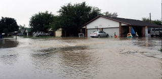
Water flows into a neighborhood Thursday, Oct. 22, 2015, in Midland County, Texas following heavy rains overnight. One home owner said he had water in his garage and his neighbor had water in his house. Mark Sterkel / Odessa American via AP
 
In total, parts of Texas could see 3 to 6 inches — and upwards of 10 inches locally — through Sunday, aid Lamont Bain, a meteorologist in the National Weather Service's Fort Worth office, said.
That's because Patricia, the strongest storm ever measured on the planet, is expected to make landfall along Mexico's Pacific coast Friday night before pushing north into the United States.


Read More and Watch Videos Here

Tuesday, October 20, 2015

Extreme Weather Australia State of New South Wales, Sydney


Audience submitted image
..........
 Extreme WeatherAustraliaState of New South Wales, SydneyDamage levelDetails
..........
Description
Emergency crews are working to restore power to about 5,000 homes and businesses after a severe storm swept across Sydney and parts of New South Wales. The storm was forecast to bring heavy rainfall that could lead to flash flooding in parts of the Mid North Coast, Hunter and Central Tablelands. The Bureau of Meteorology (BoM) has cancelled its warning for Metropolitan Sydney and the Illawarra. However, a severe thunderstorm warning for damaging winds has been issued for residents in parts of the Hunter, Central Tablelands and far western NSW. A spokesman for Ausgrid said about 5,000 customers in Sydney are without power, with Hurstville among the worst affected areas. Earlier, power was restored to about 10,000 homes around Arncliffe. The spokesman said about 15,000 homes lost power during the height of the storm. Fire and Rescue NSW said firefighters had been kept busy with more than 60 incidents caused by wet weather and lightning strikes. Paramedics were called to Newtown in Sydney's inner west after reports someone was possibly struck by lightning. Police said the person was "conscious and breathing" when the ambulance arrived. The BoM said the lower western district of NSW was likely to be hit with damaging winds. Locations affected might include Wentworth. The State Emergency Service said a number of trees fell in Campbelltown and Bankstown. A strong wind warning is also in place for the Coffs Coast, Macquarie Coast, Hunter Coast and Sydney Coast.
..........
WeatherZone

Crews kept busy restoring power after storm hits Sydney, parts of NSW

Tuesday October 20, 2015 - 23:33 EDT
 
Audience submitted image
Fire and Rescue NSW said firefighters had been kept busy with more than 60 incidents caused by the wet weather and lightning strikes. - Audience submitted
 
Emergency crews have been kept busy restoring power to homes and businesses after a severe storm swept across Sydney and parts of New South Wales.


Late on Tuesday night, the Bureau of Meteorology (BoM) issued a severe thunderstorm warning with damaging winds for locations including Broken Hill, Wentworth and Fowlers Gap.
                       

Read More Here
..........

..........

Sunday, October 18, 2015

Flash flooding north of Los Angeles sent water and mud flowing into canyons and across roadways trapping hundreds of drivers. Blocked Interstate has now been opened


Cars Trapped In Mud After Rain Brings Flash Flooding To Los Angeles

There were no immediate reports of any injuries.

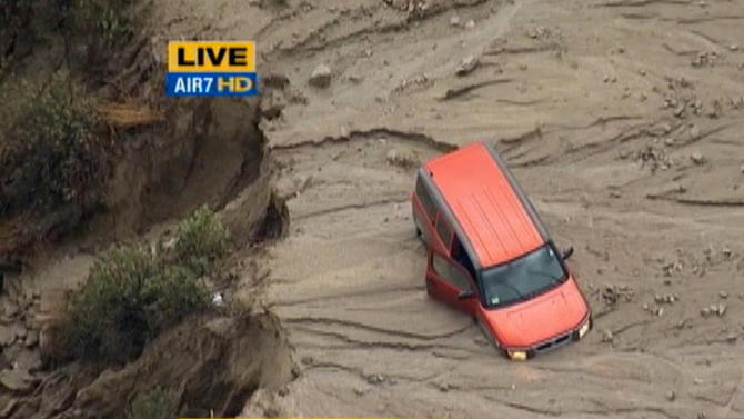
<span class='image-component__caption' itemprop="caption">This still frame from video provided by KABC-TV shows vehicles stuck in a muddy road in the mountainous community of Lake Hughes, Calif., about 65 miles north of downtown Los Angeles, Thursday, Oct. 15, 2015.</span> ASSOCIATED PRESS This still frame from video provided by KABC-TV shows vehicles stuck in a muddy road in the mountainous community of Lake Hughes, Calif., about 65 miles north of downtown Los Angeles, Thursday, Oct. 15, 2015.
 

LOS ANGELES (AP) — Flash flooding north of Los Angeles sent water and mud flowing into canyons and across roadways Thursday, trapping drivers and closing a stretch of one of the state's main north-south freeways.

The California Highway Patrol reported a 30-mile section of Interstate 5 was blocked by flooding near Fort Tejon, about 75 miles north of downtown Los Angeles.

Drivers stuck in the mud waited for roads to be cleared while thousands more were diverted to alternate routes expected to take four or more hours to traverse through the mountain region in Southern California.

There were no immediate reports of any injuries.

"Due to the drought and fires, all the rain coming down heavily is causing floods," CHP Officer Andrew Mack said. "We have a lot of people up there trapped on the roadway."


Read More and Watch Video Here

..........


Flooding, mudslides strand Southern California drivers following storm

Reuters

LOS ANGELES (Reuters) - Heavy rains touched off flooding and mudslides in foothill communities north of Los Angeles on Thursday, swamping cars, stranding drivers and prompting authorities to close several major roads.

Read More Here

......................

The Latest: All Interstate 5 lanes reopened after mudslide

Associated Press
 
This image taken from video provided by KABC-TV, shows a vehicle stuck along a muddy road in the mountainous community of Green Valley, Calif., about 65 miles northwest of downtown Los Angeles on Thursday, Oct. 15, 2015. Flash flooding in northern Los Angeles County has filled several roads with mud, stranding vehicles and blocking traffic on one of the state’s main highways. (KABC-TV via AP) MANDATORY CREDIT; TV OUT
.
View gallery
LOS ANGELES (AP) — The latest on mudslides that closed a California interstate (all times local):
6:20 p.m.

All lanes of Interstate 5 have been reopened, about 24 hours after the major north-south artery linking Los Angeles and Central California was blocked by a mudslide.

A spokeswoman with the California Highway Patrol says all lanes were cleared shortly after 6 p.m. Friday. Two southbound lanes and the northbound ones were reopened earlier in the day.
A storm system that drenched northern Los Angeles County Thursday sent mud and debris onto the roadway, trapping hundreds of drivers. Highway crews worked overnight and throughout Friday to free vehicles and clear the roadway.

To the west, State Road 58 is expected to remain closed for days.
5:55 p.m.

A fresh round of flash flooding stranded dozens of vehicles on a highway in Central California, but the troubles appear to be only temporary.

Santa Barbara County fire spokesman Dave Zaniboni said the Friday afternoon flooding affected Highway 166 west of Cuyama. That's a remote, sparsely populated community about 50 miles north of Santa Barbara.

Zaniboni says about 100 vehicles, including a school bus, were stuck on the roadway at one time but that traffic began moving by Friday evening.


Read More Here

Freeze watch issued for parts of NC


Freeze watch issued for NC
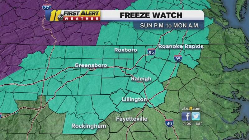
The National Weather Service said frost and freezing conditions are possible in parts of central North Carolina tonight and Sunday night.
The National Weather Service said frost and freezing conditions are possible in parts of central North Carolina Saturday and Sunday night

Click here for weather alerts.

Click here for the latest forecast.

A frost advisory was issued for northern counties beginning early Sunday morning. The freeze watch goes into effect Sunday night into Monday morning.

A freeze watch means sub-freezing temperatures are possible. Meteorologist Chris Hohmann said the coldest morning will most likely be Monday when clear skies, light winds, and dry air combine with the chilly air mass to send temperatures into the low and mid-30s across the region, with some upper 30s in the Sandhills.


Read More and Watch Video Here

Friday, October 16, 2015

Flash Flood - Spain, Province of Alicante, Moraira


Severe weather in the Alicante province


..........
Flash FloodSpainProvince of Alicante, MorairaDamage levelDetails
.........
Description
The province has experienced another episode of extreme heavy downpours with over 83 litres of rain per square metre recorded in the coastal town of Moraira, Alicante and a drop of 10 degrees in temperature in some areas in the province in just 24 hours. Nearby Javea received 40 litres per square metre. Alicante was the province most affected by the rains on October 13 according to the State Meteorological Agency, AEMET. The day started off with heavy low cloud and the rains started around 9am, not letting up for most of the day. Calpe, located just 12 kilometres from Moraira also experienced heavy rains, with many of the town's roads including the Avenida Juan Carlos I being closed by the police. More than a dozen vehicles were left stranded as drainage systems struggled to deal with the excessive accumulation of water, which was approximately half a metre deep on some roads. The hugely popular Oktoberfest that is currently running in Calpe was also affected by the heavy rains and was forced to close until conditions improve. The province remains on yellow alert for high risk of rains and strong weather conditions.
.........


Sunday, May 18, 2014

Snow Storm - State of Colorado, Denver

Earth Watch Report  -  Extreme Weather -  Snow Storm


Spring and winter collide as a heavy wet snowstorm hit Colorado on Mother&#8217;s Day, covering blooms and blossoms and prompting birds to look for cover.
Spring and winter collide as a heavy wet snowstorm hit Colorado on Mother's Day, covering blooms and blossoms and prompting birds to look for cover. (Steve Nehf, The Denver Post)

.....
Snow StormUSAState of Colorado, DenverDamage levelDetails

.....

RSOE EDIS

Description
Denver received five inches of snow, which mostly stuck on grass and trees instead of roadways. It continued to snow into Monday morning, which slowed down the morning commute in the metro area. Driving conditions were the worst in the mountains, with certain areas receiving over a foot of snow.

.....

Winter storm pounding Colorado mountains; 10 inches possible in Denver

By Joey Bunch and Tom McGhee
The Denver Post

Posted:   05/11/2014 09:47:13 AM MDT

While Denver dealt with slushy streets and snow on tender buds, the Colorado high country and foothills fought a winterlike battle with road closures, fender benders and heavy tree damage Sunday.Two law enforcement officers were injured in separate accidents as they helped motorists Sunday night, according to the State Patrol.
A Jefferson County sheriff's deputy was injured along with three others when an SUV struck his cruiser that was parked on the side of U.S. 285 near the community of Doubleheader just after 7 p.m. None of the injuries were thought to be life-threatening, according to the sheriff's department.
The cause of the crash was under investigation, but weather is likely a factor, said sheriff's spokeswoman Jacki Kelley.
Four people, including a Jefferson County sheriff&#8217;s deputy, were injured when seven cars slid into one another on U.S. 285 near the community of
Four people, including a Jefferson County sheriff's deputy, were injured when seven cars slid into one another on U.S. 285 near the community of Doubleheader on Sunday. (Courtesy Inter-Canyon Fire Protection District)
At 7:38 p.m. a state trooper was injured when his vehicle was hit as he was parked along U.S. 285 near Fairplay. A car slid across the road and hit the trooper's vehicle head-on.
The trooper sustained minor injuries, but no one else was hurt, according to the State Patrol.

 Read More Here
.....
Enhanced by Zemanta

Extreme Weather - State of Texas, Waco


Earth Watch Report  -  Extreme Weather


.....
Extreme WeatherUSAState of Texas, WacoDamage levelDetails

.....

RSOE EDIS

Description
A powerful spring storm produced heavy rain and frequent lightning that caused widespread street flooding Monday night in the Waco area leaving some motorists stranded and leading to some high-water rescues. The storm also caused a series of lightning-related fires and a number of mostly minor traffic accidents Monday night. Three-quarter inch hail fell in Belton. Water was beginning to accumulate on the edges of Old Waco Road Monday night in Belton, police said. Flooding from heavy rain shut down the intersection of New Road and Waco Drive Monday evening in Waco, stranding some drivers in their vehicles. Heavy rain caused flooding on other area streets and on Interstate 35, in Waco where traffic was reported to be stopped. Flooding in Waco was reported in the 900 block of North 31st Street; 9100 block of Panther Way; intersection of North 23rd and Waco Drive; Lake Shore and MLK; 30th and Austin; Interstate 35th at South 6th and South 7th Streets; 5400 block of Franklin; Lake Air and Waco Drive; North 36th and Fort; 2200 block of Herring; Sanger and Towne Oakes, and 100 block of Richland Drive, police said.
A motorist was reported trapped in a vehicle on Londonderry Drive and Medical Parkway. Flooding was also reported along Valley Mills Drive. Seven to 12 inches of water was reported just after 7 p.m. on Panther Way behind Midway High school. Police in Waco and surrounding communities were responding to other reports of motorists stranded by high water. Flooding is likely in low-lying areas and at low-water crossings throughout the night in Central Texas and motorists are advised to turn around if they encounter water on roadways. Area fire departments also responded to a series of calls involving residential fires that were evidently caused by lightning strikes. A lightning strike also set a tree on fire in Waco. Law enforcement agencies also responded to a number of reports of mostly-minor traffic accidents on area streets and highways. A flash flood warning was in effect until 8:45 p.m. for McLennan County and the region is under a flash flood watch through at least late Monday night. Flooding was also reported in the Whitney area. Flash flash flood warnings were in effect for Hill County until 8:30 p.m. and Falls County until 9:45 p.m. Two feet of water was reported on a road near Whitney in Hill County and water was reported over the road on FM 94 east of Blum. Water was reported over Highway 16 southwest of Goldthwaite and Highway 84 near Mulin in Mills County. Heavy rain is possible through the evening hours and overnight.

.....

More Rain Possible After Night Of Storms, Flooding

Flooding in Whitney (Photo courtesy of Scott Hull)
(May 13, 2014)--Official rainfall totals in Bell County ranged from less than an inch to just less than 3 inches overnight
In Bosque County totals ranged from about 1.3 inches to about 3.5 inches.
Official totals in Coryell County were just less than an inch.
Totals in Falls County ranged from just more than 2 inches to a little more than 3 inches.
Official totals in Hill County ranged from about 1.5 inches to 3.6 inches.
In Lampasas County, totals ranged from less than an inch to about 1.5 inches.
More than 4 inches was recorded in Groesbeck, but in other parts of Limestone County totals were as low as about ½ inch.
McLennan County totals ranged from about 1.7 to 3.4 inches.
In Milam County, official totals ranged from about 1 ¾ inches to 2.5 inches.

(May 13, 2014) Showers and isolated thunderstorms are again in the forecast Tuesday after a night of heavy rain that caused widespread street flooding in the Waco area, leaving some motorists stranded in rising water.
As much as 4 inches of rain was recorded in some parts of Central Texas overnight.
If rain does fall, it’s not expected to be as heavy and should not cause significant flooding, forecasters said.
Severe weather isn’t expected, forecasters said.
More than 30,000 homes and businesses lost electricity in Texas as a result of the storm, but only small and scattered outages were reported Tuesday in the Waco-Temple-Killeen area.
The story was different Tuesday elsewhere in the state, however.
CPS Energy reported nearly 19,000 homes and businesses without power Tuesday mainly in the San Antonio area.
Austin Energy had about 1,600 customers without electricity.

.....
Enhanced by Zemanta

Friday, May 2, 2014

Florida and Alabama Storms - Hundreds rescued from floodwaters

 kvue.com  -  ABC News


Hundreds rescued from floodwaters in Fla., Ala.

Hundreds rescued from floodwaters in Fla., Ala.
Credit: AP
Vehicles rest at the bottom of a ravine after the Scenic Highway collapsed near Pensacola, Fla., Wednesday April 30, 2014. Heavy rains and flooding have left people stranded in houses and cars in the Florida Panhandle and along the Alabama coast. According to the National Weather Service, an estimated 15-20 inches of rain has fallen in Pensacola in the past 24 hours. (AP Photo/Pensacola News Journal, Katie E. King)

by Associated Press
kvue.com
Posted on April 30, 2014 at 1:55 PM


PENSACOLA BEACH, Fla. (AP) -- People were plucked off rooftops or climbed into their attics to get away from fast-rising waters when nearly 2 feet of rain fell on the Florida Panhandle and Alabama coast, the latest bout of violent weather that began with tornadoes in the Midwest.
In the Panhandle, roads were chewed up into pieces or wiped out entirely. Cars were submerged and neighborhoods were inundated, making rescues difficult for hundreds of people who called for help when they were caught off guard by the torrential rains in the span of about 24 hours.
In the aftermath, people cruised around on paddleboards. Boats and Humvees zigzagged through the flooded streets to make rescues. About 30,000 people were without power, and one woman died when she drove her car into high water, officials said.
Kyle Schmitz was at home with his 18-month-old son Oliver Tuesday night when heavy rain fell during a 45-minute span in Pensacola. He gathered up his son, his computer and important papers and decided to leave when the waters quickly started to rise.
"I opened the garage and the water immediately flowed in like a wave," he said. "The water was coming up to just below the hood of my truck and I just gassed it."
Schmitz and his son made it out safely. He returned Wednesday to assess the damage at his rented home in the East Hill neighborhood. The water was up to his shins and he feared he would never again live in the home.
Elsewhere, water lingered above mailboxes. Florida Gov. Rick Scott said officials received about 300 calls for rescues and had completed about 210 of those by midmorning. Some people abandoned flooded cars and walked to find help.
"It's gotten to the point where we can't send EMS and fire rescue crews out on some 911 calls because they can't get there," Escambia County spokesman Bill Pearson said. "We've had people whose homes are flooding and they've had to climb up to the attic."

Read More Here
Enhanced by Zemanta