Global Weather Phenomenon-Natural/Technological Disasters-Space Events-Epidemic/Biological Hazards-
Nuclear Events :
News Affiliate of Family Survival Protocol.com
A
resident walks past big waves spilling over a wall onto a coastal road
in the city of Legaspi in Albay province, south of Manila, on Dec. 14.
More
than 700,000 people in the central Philippines fled to safer areas for
fear of giant waves, floods or landslides as Typhoon Melor slammed into
the archipelago nation Monday, officials said.
Meteorologists
from the Philippine Atmospheric Geophysical and Astronomical Services
Administration (PAGASA) monitor and plot the direction of powerful
Typhoon Melor at their headquarters in suburban Manila on Dec. 14.
Melor
crossed the central Burias Island late Monday, with authorities warning
that traditional thatched homes were unlikely to withstand the strong
winds and that crops may suffer heavy losses. There were no immediate
reports of casualties or damage.
The typhoon brushed the northern
tip of Samar, a farming island of 1.5 million people, early Monday with
winds gusting up to 185 kilometres (115 miles) per hour, the state
weather bureau said.
Samar was among areas devastated in 2013 by
Typhoon Haiyan, when giant waves wiped out entire communities and left
7,350 people dead or missing.
Authorities warned that Melor's
powerful winds might whip up four-metre-high (13-feet) waves, blow off
tin roofs and uproot trees. They said heavy rain within its
300-kilometre diameter could trigger floods and landslides.
Sinkholes, slides endanger entire neighborhood in Tillamook
A
neighborhood of seven homes overlooking the Tillamook River are banding
together after extreme weather has caused their hillside to shift,
sending bits of road, mud and trees onto their homes and barns.
It
began Monday as a few little cracks on Burton Hill Road, just outside
Tillamook. By Wednesday the cracks had collapsed into a quarter-mile
series of sinkholes and creeping mud that put three homes at risk,
pushed a barn off its foundation and left homeowners fearful of what
will move next.
As the rains continue, they say only one thing is clear:
No one is coming to the rescue.
Morgan
Kottre, 27, said she and her neighbors – some of them relatives – have
been told by county, state and federal officials that they don't qualify
for assistance because Burton Hill Road and the lower Hillside Drive
are private roads on private land. Same story from at least one
insurance company. Kottre said a representative told one family the
devastation qualifies as an "act of god," which the insurer doesn't
cover.
"In theory, we could try to fight it," she said, "but right now we're just trying to fight the land." Storms over the past week that have brought flooding and
landslides across northwestern Oregon. On Saturday afternoon, blizzard
conditions closed three highways in Southern Oregon. The extreme weather
has caused at least two deaths in Oregon and federal officials set
early damage estimates at about $15 million.
Tillamook County was
among the 13 counties where Oregon Gov. Kate Brown declared a state of
emergency. In fact, not far from Kottre's home on Saturday night, the town of Oceanside was cut off as the only road out of town was closed due to a failed culvert.
Westmeath
County Council has placed two families in alternative accommodation as
flooding continues to threaten parts of Athlone town. While the family's
homes on the west side of town were not flooded, both houses suffered
flooding in 2009 and the families asked to be moved because they found
the current situation too stressful. River Shannon levels in Athlone
rose by about 8cm between Wednesday and Thursday. However, due to the
efforts of locals, council staff, the Defence Forces and the civil
defence, floodwater was kept out of houses. Additional pumps have been
deployed in some of the worst-affected areas. In places such as Deerpark
Road, the water levels appear to have dropped. Despite the flood
defence measures, there are major concerns about the impact further
predicted bad weather could have on the town. Director of services at
Westmeath County Council Barry Kehoe is hoping the forecast provided by
the ESB is not accurate. It suggests a further rise of 31cm which would
see the Shannon at levels just below those of 2009. "There is a bad
forecast for Saturday of heavy rainfall," Mr Kehoe said. "The effect of
it will be to drag out the whole scenario into next week." While some
waste water had mixed with the flood water, Mr Kehoe said there was no
problem with the water supply in the town. "It [the floodwater] always
needs to be treated as dirty water and a hazard," he said, adding that
the council was prepared for evacuations. In the case of the two
families who were provided with accommodation on Tuesday and Wednesday,
Mr Kehoe said "some people have requested alternative accommodation as
it is just too stressful for them". In outlying areas such as Clonbonny
and Carrickobrien, some people were "marooned", Mr Kehoe said. A
transport service was being provided to bring children to school, to
take people to medical appointments and for other essential journeys.
Although areas like the Strand and Wolfe Tone Terrace remain under
threat on the east side of town, and Deerpark Road and The Park and
Parnell Square on the west side, the remainder of the town is continuing
to operate as normal. The Defence Forces has between 30 and 35 troops
filling sandbags and moving heavy pumps in Athlone. A spokesman said the
troops had been on flood defence operations since 7am.
Athlone fearful things will worsen next weekFriday, December 11, 2015
by Eoghan MacConnell
Westmeath
County Council has placed two families in alternative accommodation as
flooding continues to threaten parts of Athlone town.
While
the families’ homes on the west side of town were not flooded, both
houses suffered flooding in 2009, and the families asked to be moved
because they found the situation too stressful.
Flood defence
measures prevented flooding from occurring despite rising water levels
in Athlone, Co Westmeath on Wednesday night. It’s estimated that 90
houses could flood in Athlone if water levels reach those last seen in
November 2009.
River Shannon levels in Athlone rose by around 8cm
between Wednesday and Thursday. However, thanks to the efforts of
locals, council staff, the defence forces and the civil defence,
floodwater was kept out of houses.
By
Thursday morning the wind, which had been driving water towards the
town, had eased as workers continued to battle the floodwater.
Extra
pumps have been deployed in some of the worst affected areas. In places
like Deerpark Road, the water levels appear to have dropped. Despite
the flood defence measures there are major concerns about the impact
further predicted bad weather could have.
Families request evacuation as flood threatens town
Locals,
council staff, Defence Forces and Civil Defence keep floodwater out of
Athlone houses with additional pumps deployed in worst-affected areas
Thu, Dec 10, 2015, 22:00
Eoghan MacConnell
Flooding this week along the banks of the Shannon river near Athlone town. Photograph: Brenda Fitzsimons/The Irish Times
Westmeath County Council has placed two families in alternative accommodation as flooding continues to threaten parts of Athlone town.
While
the family’s homes on the west side of town were not flooded, both
houses suffered flooding in 2009 and the families asked to be moved
because they found the current situation too stressful.
River
Shannon levels in Athlone rose by about 8cm between Wednesday and
Thursday. However, due to the efforts of locals, council staff, the Defence Forces
and the civil defence, floodwater was kept out of houses. Additional
pumps have been deployed in some of the worst-affected areas.
In
places such as Deerpark Road, the water levels appear to have dropped.
Despite the flood defence measures, there are major concerns about the
impact further predicted bad weather could have on the town.
Storm Desmond has brought a waterfall back to life at a famous beauty spot for the first time in living memory.
While
they last, the falls at Malham Cove in the Yorkshire Dales are believed
to be the highest in England, thundering off a cliff 260ft (80m high).
Local residents
and tourists gathered on Sunday to see the phenomenon, which is
believed to be the first time the falls have flowed in hundreds of
years.
Stu
Gledhill, who filmed the scene, wrote on YouTube: “Talking to two
neighbours who are both around 80 and have both lived in Malhamdale all
their lives.
"They
have never seen this happen before, and some suggestions are that it
could be nearly 200 years since it was last recorded.”
A rescue team helps to evacuate people from their homes after Storm Desmond floods Carlisle Getty
Hundreds
of people have been made homeless and thousands more left without power
by Storm Desmond, which is thought to have broken the rainfall record
set in 2009.
46 severe flood warnings remain in place in north-west England, where Cumbria was declared a major incident.
The
army has been drafted in to help evacuate people from their homes and
rescue those stranded after the river Eden burst its banks at
Appleby-in-Westmorland, sweeping away bridges and sinking some
properties under a metre of water.
About 350 soldiers were dispatched
from the 2nd Battalion the Duke of Lancaster's Regiment to Carlisle,
one of the worst affected towns. A Chinook helicopter and mountain
rescue teams were also sent out to assist victims.
11,000 homes in Lancaster have had electricity restored, with 44,000 more expected to have power back by Monday evening.
According to the BBC,
provisional figures suggest more than 340mm of rain fell in 24 hours in
the Lake District, breaking the record of 316.4mm previously held by
Seathwaite, Cumbria, in 2009.
STORMS UPDATE: Army drafted in to deal with Storm Desmond chaos
Crook O Lune near Lancaster
16:42Sunday 06 December 201512:43Saturday 05 December 2015
The
extent of the devastating flooding from the torrential rain and gale
force winds that have hit Lancashire in the last 36 hours is being
revealed.
Army trucks have been stationed at a hospital in
Lancaster to act as ambulances after flooding cut the city off from the
power grid and blocked all but one access route.
Crook O Lune near Lancaster
The
hospital has also cancelled all non-emergency operations tomorrow and a
number of clinics as emergency services struggle to deal with the scale
of the incident.
The north of the county - in particular Lancaster and surrounding areas - has been by far the worst hit.
From
domestic electrical faults to people stuck in cars in flood water,
Lancashire Fire and Rescue Service has been inundated with calls for
help.
A spokesperson for the service said this morning: “In the
last 24 hours we’ve had approximately 300 calls, and we’ve attended
probably 200 incidents.
Storm Desmond: Homes flooded and thousands without power
6 December 2015
Tens
of thousands of homes are without power after Storm Desmond caused
severe flooding and travel disruption across northern England and parts
of Scotland.
Power at about 55,000 homes could be off for "days" following flooding at an electricity substation in Lancaster.
Prime Minister David Cameron said the government was doing all it can to help people and prevent further damage.
Mr Cameron will chair a meeting of the Cobra contingencies committee on Monday to co-ordinate the emergency response.
"I
would like to pay a huge tribute to all those emergency workers and
troops who have worked tirelessly to respond to this weekend's events,"
he said.
"There has been a tremendous response from local communities too, with people taking in families affected by the flooding."
Storm
Desmond has lashed large areas of England and Scotland as severe
flooding and winds of up 80mph caused police to declare a major
incident.
More than 30 severe storm warnings – indicating danger
to life – were issued in Cumbria and Northumberland, and two severe
storm alerts were issued in south-west Scotland as heavy rain
continued well into Sunday.
Read more
Man, 90, dies after ‘gust of wind blows him against moving bus’
Homes
in the Cumbrian towns of Appleby and Keswick were evacuated and drivers
were rescued from stranded cars as flood waters breached defences,
submerged streets and disrupted road and rail services.
In London,
a 90-year-old man died near Finchley Central station after he was blown
into the side of a moving bus by a gust of wind.
The storm also
caused disruption in north Wales, Northern Ireland and North Yorkshire,
where thousands of homes were left without electricity.
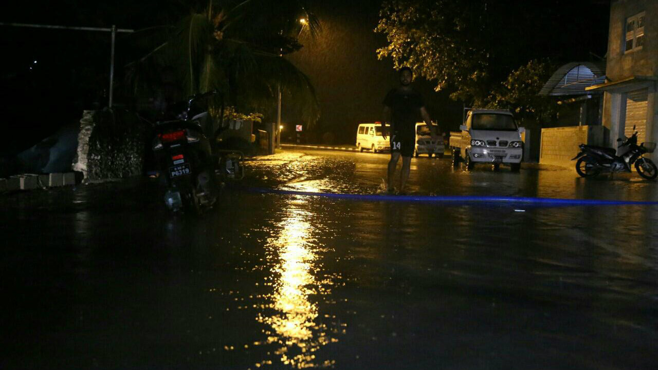
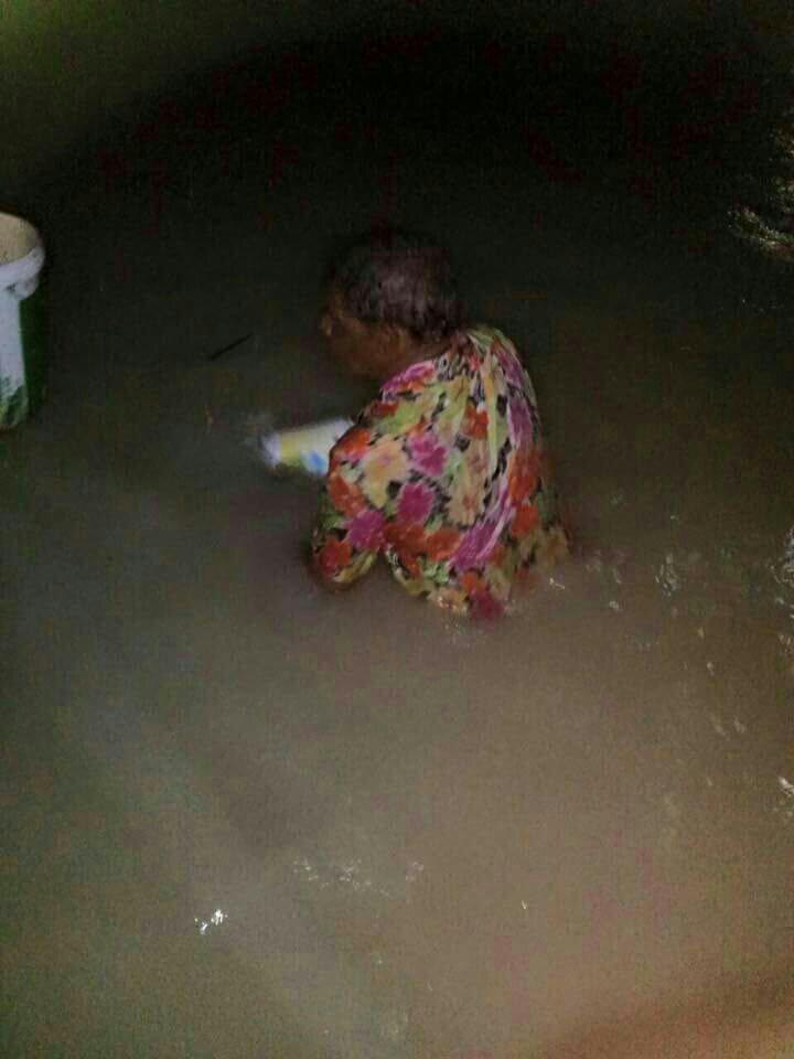
Southern
Addu City has suffered the worst storm damage in 40 years after 12
continuous hours of torrential rain left streets inundated and flooded
some 200 households.
“This is the worst flooding I’ve seen in
decades. The water is knee-deep in most areas, and a majority of houses
are under a foot of water,” saud Abdulla Thoyyib, the deputy mayor.
The
Feydhoo and Maradhoo-Feydhoo wards suffered the most damage. According
to the Maldives Red Crescent, some 32 houses in Feydhoo and 11 houses in
Maradhoo-Feydhoo suffered major damage. A majority of household
appliances were destroyed, a spokesperson said.
Residents are now
worried of water contamination as sewers are full and overflowing. The
city, home to some 20,000 people, and the second most populous region,
is out of chlorine, according to Thoyyib.
The Maldives National
Defence Forces have set up water pumps in the three worst affected
wards. Sand bags have been piled up to stop water entering into 17
houses in the Feydhoo ward.
The rain, which started at
3pm on Tuesday, continued for 12 hours. The department of meteorology
recorded 228mm of rain, the worst in 40 years in the Maldives.
“This kind of rain is not common and it has damaged houses that are normally safe,” Thoyyib said.
Heavy
rains, flooding and a spike in new arrivals could threaten the lives of
over 110,000 Burundian refugees in overcrowded camps in Tanzania, six aid agencies said on Monday, amid warnings of rising political tension in Burundi.
Life-threatening
malaria and diarrhoea have been spreading in Nyarugusu, the world’s
third largest refugee camp, since the rainy season began, and damage
caused by a powerful El Nino has left aid agencies short of funds
throughout east Africa.
“Refugees
are arriving in the hundreds every day,” the agencies, which include
Oxfam, Save the Children and HelpAge International, said in a statement.
“Many
people are still living in overcrowded mass shelters months after their
arrival, where wet floors and cramped conditions mean that the risk of
respiratory infections and waterborne diseases is high.”
The agencies also fear a fresh outbreak of cholera, which killed 33 Burundian refugees in western Tanzania in May, as heavy rain sometimes makes toilets overflow and flood shelters.
Chennai:
Tamil Nadu continued to experience monsoon fury on Sunday, with heavy
rains pounding various parts of the state under the influence of a well
marked low pressure area over Bay of Bengal, as the death toll from
rain-related incidents climbed to 59.
There seemed to be no
respite from the downpour with many parts of the city coming under water
even as the weatherman forecast more rains for the next 24 hours,
beginning 08:30 am.
The India Meteorological Department said in a
bulletin on Sunday that the well-marked low pressure area over southwest
Bay of Bengal adjoining Sri Lanka persisted and "it is likely to move
west-northwestwards towards Tamil Nadu coast and would concentrate into a
Depression during next 24 hours."
People help a man carry his two-wheeler on a cycle cart as they wade through a waterlogged subway in Chennai. AP
Under its influence, more rains were expected in the next 24 hours, the Regional Meteorological Department said.
Anaikaracharthiram
(Nagapattinam) received the maximum rainfall of 18 cm recorded till
8:30 am, RMC Director SR Ramanan said, adding, Sirkali from the same
district registered 17 cm. Chennai received three cm rainfall between
8:30 am and 11:30 am on Sunday.
He said heavy to very heavy rains
could be expected in the northern coastal districts of the state in the
next 24 hours while there could be rain in the rest of the districts.
Rains were also expected in Puducherry on Monday.
Over
10 million people in the south-central U.S. face potential flash
flooding as a slow-moving storm dumps heavy rain through the weekend —
and only intensifies in the wake of Hurricane Patricia, forecasters
warn.
Cars were reportedly stranded by floodwaters in Corsicana,
south of Dallas, after nearly 10 inches of rain fell by Friday afternoon
since midnight, the National Weather Service said.
Officials in
Galveston County were considering a voluntary evacuation of Bolivar
Peninsula but would reevaluate Saturday morning.
Much of central
and southeast Texas were under a flood watch Friday and there were flash
flood warnings issued for Navarro and Hamilton counties, according to
the National Weather Service.
Over 4 inches of rain fell on
Collins by Friday afternoon and more than 6 inches of rain fell over 48
hours in parts of Tarrant County by Friday afternoon, the NWS said.
Water
flows into a neighborhood Thursday, Oct. 22, 2015, in Midland County,
Texas following heavy rains overnight. One home owner said he had water
in his garage and his neighbor had water in his house. Mark Sterkel / Odessa American via APIn
total, parts of Texas could see 3 to 6 inches — and upwards of 10
inches locally — through Sunday, aid Lamont Bain, a meteorologist in the
National Weather Service's Fort Worth office, said.
That's because Patricia, the strongest storm ever measured on
the planet, is expected to make landfall along Mexico's Pacific coast
Friday night before pushing north into the United States.


 Flooding this week along the banks of the Shannon river near Athlone town. Photograph: Brenda Fitzsimons/The Irish Times


 A rescue team helps to evacuate people from their homes after Storm Desmond floods Carlisle