Showing posts with label Volcanic Events. Show all posts

Friday, December 18, 2015

A volcano in Russia's Kamchatka region has spewed ash cloud, covering a local village with a thin layer of soot


 Village Covered in Film of Soot After Kamchatka Volcano Spews Ashes


NASA / JSC / Wikicommons
 
 
A volcano in Russia's Kamchatka region has spewed ashes, covering a local village with a thin layer of soot, the Emergency Situations Ministry said on Wednesday, the RIA Novosti news agency reported.

The ash cloud from the Shiveluch Volcano reached 6,500 meters above sea level, the ministry said in a statement, RIA Novosti reported. The volcano is 3,283 meters high.


Read More Here

Sunday, December 13, 2015

Indonesia's Mt. Bromo's volcanic activity has increased in recent days. Meanwhile, earth tremors had increased since Thursday night, Mt. Bromo Volcanic Monitoring Post (PPGA) M. Syafii


Indonesia: Mount Bromo erupts, spews ash high into the sky

Wednesday, December 9, 2015

Costa Rica’s Turrialba Volcano erupted and launched ash and vapor into the air for about 10 minutes, report experts at the University of Costa Rica’s National Seismological Network


Volcanic eruptions

New explosion of ash at Costa Rica's Turrialba Volcano

L. Arias
Costa Rica’s Turrialba Volcano, located 50 kilometers east of San José, erupted at 1:12 p.m. on Monday and launched ash and vapor into the air for about 10 minutes, experts with the University of Costa Rica (UCR) and the National University (UNA) reported.

This is the second event this month after another 10-minute explosion recorded on Dec. 7. also spewed ash and gases into the air.

Experts from UNA’s Volcanological and Seismological Observatory of Costa Rica (OVSICORI) reported the explosion reached just under 400 meters in height.

UCR’s Mauricio Mora at 2:30 reported there were no more explosions. Mora was conducting an inspection in the volcano’s surrounding areas and said experts are evaluating whether the explosion was an isolated event or is part of an eruptive process.


Read More Here

Monday, December 7, 2015

Volcano Eruption : Japan, [Mt Aso volcano] Prefecture of Kumamoto


File:Eruption of Mount Aso ISS045.jpg
NASA Photo ID : ISS045-E-21851      Wikimedia.org
...........................................................................................
..........


Volcano Eruption in Japan on December 07 2015 08:00 AM (UTC).
Mount Aso in southwestern Japan's Kumamoto prefecture had a small-scale eruption Monday morning, its first since Oct 23, the weather agency said. The eruption spewed smoke about 700 metres above the No. 1 crater of Mt Nakadake, one of the five peaks that constitute Mt Aso, the Japan Meteorological Agency said. There have been no reports of people injured so far. The agency maintained its volcanic alert level at 2 on the scale of 5, warning people not to approach the crater. Rocks could fall within one kilometre of the crater, it said. "An eruption of this level can happen at any time," an official of the agency's Fukuoka Regional Headquarters said. The alert level for Mt Aso was raised to 3 following its eruption on Sept 14, which warned against approaching the mountain, but it was lowered by one notch on Nov 24 amid diminished volcanic activity.
..........

..........

Sunday, December 6, 2015

Japan's volcanic Nishinoshima Island, has grown Twelve Times Bigger Since it's second peak Popped Up Two Years Ago


FORBES


New Island Grows Twelve Times Bigger Since Popping Up Two Years Ago

 
I cover science and innovation and products and policies they create.

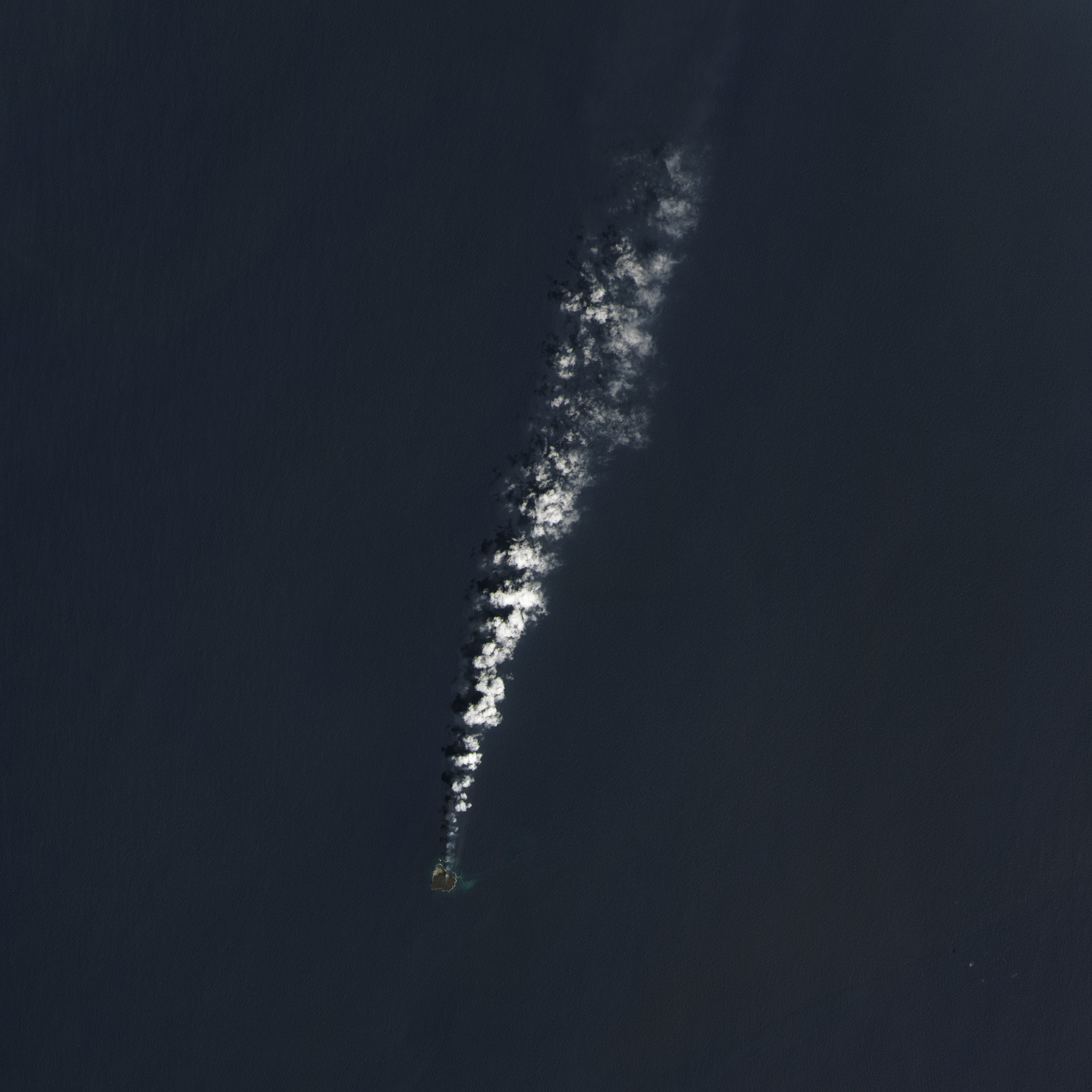
A NASA image from 2014

It’s not exactly a Pacific beach resort just yet, but the Japanese Coast Guard reports that a volcanic island that first popped up in the middle of the ocean two years ago has already grown to twelve times its initial size.

Molten rock cooled by the ocean first poked out of the water in November, 2013, when it was initially spotted next to island Nishinoshima, which it eventually grew to engulf.


Read More Here

 
...............................................................................................
Click to Open Overlay Gallery Via  WIRED
.................................................................................................
Bad Astronomy
The entire universe in blog form
April 6 2014 7:45 AM

A New Volcanic Island Swallows Its Older Sister


Tens of thousands of years ago, an undersea volcano a thousand kilometers south of Tokyo reached a milestone: Its peak reached the surface of the Pacific Ocean. It became an actual island. For millennia it slept, but in the 1970s a series of eruptions grew the island, which was named Nishinoshima. It was tiny, just a couple of hundred meters across.
But then there were a series of eruptions just south of the island in November 2013, in a still-submerged part of the volcano. This created a second peak, which poked through the water’s surface to become a new island just a few hundred meters from Nishinoshima.
That wouldn’t last: The new island grew as the volcano continued to erupt, and just before New Year’s Day 2014, the new island grew so big it actually connected to the old island. Now there is just one … and it’s still erupting, as you can see in this lovely image taken by the Landsat 8 satellite on March 20, 2014:
nishinoshima island
 
The new volcanic Nishinoshima Island, seen FROM SPAAAAACE. Click to hephaestenate.

Photo by Jesse Allen and Robert Simmon, usingLandsatdata from the USGSEarth Explorer.


Read More Here

Saturday, November 21, 2015

Indonesia's Mt Sinabung volcano erupts again


Rendy Cipta Muliawan - Flickr: Erupsi Gunung Sinabung dan Dampaknya dilingkungan sekitar
Damaged plants due to eruption    Wikipedia.org

............................................................................................................

Asia One

Indonesia's Mt Sinabung volcano erupts again


MEDAN - Mount Sinabung in Karo regency, North Sumatra, erupted forcefully once again on Wednesday and may threaten the opening of the Lake Toba Festival by Tourism Minister Arief Yahya in Berastagi, also in Karo, slated for Thursday.

No casualties were reported following the eruption, but pyroclastic flows drifting to the southeast affected a number of villages that have long been abandoned by residents.

"The current wind direction is directed to the southwest, but if it blows to the east the Lake Toba Festival will be disrupted as the spread of ash would reach Berastagi," Mt. Sinabung Observation Station staff member Deri Hidayat told The Jakarta Post.

Deri said the volcano discharged the clouds at 1:47 a.m. and 9:28 a.m.
He added the pyroclastic clouds, which drifted as far as 3.5 kilometers, affected Bekerah and Simacem villages.

He said both villages had long been left empty as they were inside a designated danger zone.
Deri added that Mt. Sinabung had also emitted volcanic ash to a height of 2,000 meters toward the southwest. He said the spread of ash could disrupt the Lake Toba Festival if the wind changed direction in coming days.


Read More Here

Ecuador: Tungurahua volcano erupts covering houses with ash


Cedancp      Wikipedia.org
...............................................................................................................

International Business Times

Residents from communities near Ecuador's Tungurahua volcano faced a massive cleaning operation on Thursday (19 November) after the volcano erupted, covering houses and fields with smoke and ash. Authorities issued an orange alert as emissions reached 2,500 metres above the crater.
In nearby Queros, one of the most affected communities, officials registered 10kg of ash per square metre.

As he swept the street near his house, resident Luis Vaca said the volcanic material was damaging crops. "Ash is falling everywhere; it's strong, especially in the countryside where it's falling more heavily. It's damaging the crops. It would be good if the president came to visit us," he said.


Read More Here

Wednesday, November 18, 2015

Violent Shaking Along The Ring Of Fire Continues A Progression Of Disasters That Began In September


The Economic Collapse

Are You Prepared For The Coming Economic Collapse And The Next Great Depression?
The Ring Of Fire - Photo from Wikipedia


Have you noticed that seismic activity along the Ring of Fire appears to be dramatically increasing?  According to Volcano Discovery, 39 volcanoes around the world have recently erupted, and 32 of them are associated with the Ring of Fire.  This includes Mt. Popocatepetl which sits only about 50 miles away from Mexico City’s 18 million inhabitants.  If you are not familiar with the Ring of Fire, it is an area roughly shaped like a horseshoe that runs along the outer perimeter of the Pacific Ocean.  Approximately 90 percent of all earthquakes and approximately 75 percent of all volcanic eruptions occur along the Ring of Fire.  Just within the last 24 hours, we have witnessed a 4.4, a 5.4 and a 5.7 earthquake in Alaska, a 6.8 earthquake in Chile and 20 earthquakes in Indonesia of at least magnitude 4.3.  And as you will see below, this violent shaking along the Ring of Fire seems to continue a progression of major disasters that began back during the month of September.

For whatever reason, our planet suddenly seems to be waking up.  Unfortunately, the west coast of the United States is one of the areas where this is being felt the most.  The little city of San Ramon, California is about 45 miles east of San Francisco, and over the past several weeks it has experienced a record-breaking 583 earthquakes

A total of 583 small earthquakes have shaken San Ramon, California, in the last three weeks or so – more than five times the record set 12 years ago, according to the latest US Geological Survey updates.

“It’s the swarm with the largest number of total earthquakes in San Ramon,” said USGS scientist David Schwartz, who is more concerned about the size of quakes than he is the total number of them. Still, the number tops the previous record set in 2003, when 120 earthquakes hit over 31 days, with the largest clocking in at a magnitude of 4.2.

Could this be a prelude to a major seismic event in California?

We shall see what happens.

Meanwhile, records are being shattered in the middle part of the country as well.

For instance, the state of Oklahoma has already set a brand new yearly record for earthquakes

The state recorded its 587th earthquake of 3.0 magnitude or higher early this week, breaking the previous record of 585. That record was set for all of 2014, meaning that Oklahoma has now had more 3.0 magnitude or higher earthquakes so far in 2015 than it did in all of 2014. So far this year, E&E News reports, Oklahoma’s averaged 2.5 quakes each day, a rate that, if it continues, means the state could see more than 912 earthquakes by the end of this year.

Oklahoma has also experienced 21 4.0 magnitude or greater earthquakes so far this year — an increase over last year, which saw 14.

And just over this past weekend there was a very disturbing series of earthquakes in the state

Starting with a magnitude-4.1 temblor at 5:11 a.m. close to the Oklahoma-Kansas border, the region experienced a series of six earthquakes within a 75-minute period Saturday morning, the U.S. Geological Survey reported on its website.

The largest earthquake Saturday morning was the 4.1, which had an epicenter nine miles northwest of Medford, Okla., 59 miles southwest of Wichita.

That was followed by five more quakes near Medford with magnitudes of 2.5, 2.8, 2.5, 3.1 and 2.9 – the last of which came at 6:24 a.m.

A seventh earthquake – this one a magnitude-4.2 temblor – was recorded at 12:29 p.m., 10 miles north-northwest of Medford.

So why aren’t more Americans alarmed that these records are being broken?


Read More Here

Monday, November 9, 2015

acidic fog created by volcanic eruptions on the red planet is the probable culprit for the erosion of rocks on Mars, believe scientists..


Eaten away by ‘vog’: Acid fog eroding rocks on Mars

The planet Mars showing showing Terra Meridiani is seen in an undated NASA image. © Greg Shirah


Scientists believe they have figured out why rocks on Mars are eroding. They say an acidic fog created by volcanic eruptions on the red planet is the probable culprit.
 
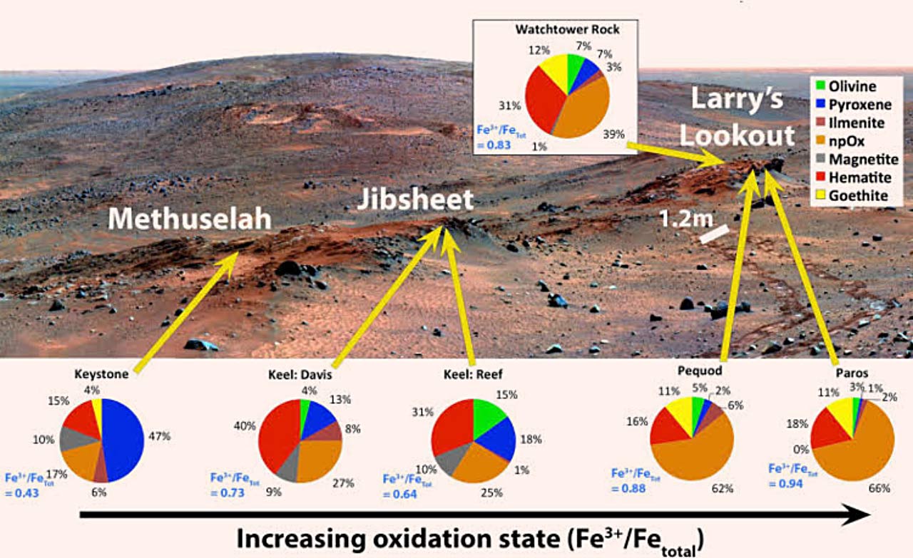
Planetary scientist Shoshanna Cole came up with the theory after studying a 100-acre area on Husband Hill in the Columbia Hills of the Gusev Crater on Mars using data gathered by a number of instruments on the 2003 Mars Exploration Rover Spirit.

She found that acidic vapors released by eruptions may have been responsible for eating away rocks on the Watchtower Class outcrops on the Cumberland Ridge and Husband Hill summit.

View image on Twitter
Acid fog corroded the surface of Mars: a new discovery from NASA's long-dead Spirit rover. http://bit.ly/1H6jT0V 


“The special thing about Watchtower Class is that it’s very widespread and we see it in different locations. As far as we can tell, it is part of the ground there,” which means that these rocks record environments that existed on Mars billions of years ago, Cole said in a press release submitted by the Geological Society of America.


Read More Here

Wednesday, November 4, 2015

One Of The Most Dangerous Volcanoes In North America Is Roaring To Life


End Of The American Dream

The American Dream Is Becoming A Nightmare And Life As We Know It Is About To Change
Popocatepetl - from Wikipedia

More than 25 million people live in the vicinity of North America’s 2nd-highest volcano, and in recent weeks this volcano has been steadily rumbling and has been spewing out massive amounts of black smoke and ash.  I have previously written about “the most dangerous mountain in the United States” (Mt. Rainier), but if the volcano that I am talking about today experiences a full-blown explosive eruption it could potentially be a cataclysmic event beyond what most of us would dare to imagine.  Popocatepetl is an Aztec word that means “smoking mountain”, and it is also the name of a giant volcano that sits approximately 50 miles away from Mexico City’s 18 million residents. 

“Popo”, as it is called by locals, was dormant for much of the 20th century, but it came back to life in 1994.  And now all of this unusual activity in recent weeks has many wondering if a major eruption may be imminent.

Historians tell us that Popocatepetl had a dramatic impact on the ancient Aztecs.  Giant mud flows produced by massive eruptions covered entire Aztec cities.  In fact, some of these mud flows were so large that they buried entire pyramids in super-heated mud.

But we haven’t witnessed anything like that in any of our lifetimes, so it is hard to even imagine devastation of that magnitude.

In addition to Mexico City’s mammoth population, there are millions of others that live in the surrounding region.  Overall, there are about 25 million people that live in the immediate vicinity of Popocatepetl.  Thankfully, we haven’t seen a major eruption of the volcano in modern times, but at some point that will change.

As most of you already know, Mexico sits on the “Ring of Fire” that stretches along the outer rim of the Pacific Ocean.  Over the past couple of years seismic activity throughout this area has started to really heat up, and according to Volcano Discovery there are dozens of volcanoes associated with the Ring of Fire that have recently erupted.


Read More Here

Saturday, October 31, 2015

Photographer: Neil from Santiago, Chile Lascar erupting in 2006 Wikipedia.org .......... Volcano Eruption Chile Antofagasta Region, [Lascar Volcano] Damage level Details .......... Volcano Eruption in Chile on Friday, 30 October, 2015 at 17:28 (05:28 PM) UTC. Description Lascar, in the northern Andes of Chile, erupted unexpectedly today, producing a small plume of light grey ash that reached 2.5 kilometers (~8,200 feet) above the volcano. The fact that there seemed to be little in the way of precursory activity (earthquakes, increased gas emissions) from Lascar suggests that this blast may have been a phreatic explosion driven by water flashing to steam in the volcano's summit crater or conduit. Due to this minor eruption, the SERNAGEOMIN has raised the alert status at Lascar to Yellow, although the volcano is in a fairly remote part of the Chilean Andes-the Global Volcanism Program reports only ~8,100 people living within 100 kilometers (62 miles) of Lascar. It has been over 2 years since Lascar last did anything and its last major eruption of Lascar was in 2005. However, it has produced some spectacular eruptions in the recent past, including the 1993 eruption that was a VEI 4. As with any of these small blasts, volcanologists will watch Lascar to see if this is a sign that it is awakening or merely a blip. Based on images on the Lascar webcam, the eruption appears to have waned rapidly. .......... WIRED Erik Klemetti Science Date of Publication: 10.30.15. 10.30.15 Time of Publication: 9:33 am. 9:33 am An Unexpected Eruption From Chile’s Lascar Volcano The light grey, ash-rich plume from Chile's Lascar during its minor October 30, 2015 eruption.Click to Open Overlay Gallery The light grey, ash-rich plume from Chile’s Lascar during its minor October 30, 2015 eruption. SERNAGEOMIN webcam Lascar, in the northern Andes of Chile, erupted unexpectedly today, producing a small plume of light grey ash that reached 2.5 kilometers (~8,200 feet) above the volcano (see above). The fact that there seemed to be little in the way of precursory activity (earthquakes, increased gas emissions) from Lascar suggests that this blast may have been a phreatic explosion driven by water flashing to steam in the volcano’s summit crater or conduit. Due to this minor eruption, the SERNAGEOMIN has raised the alert status at Lascar to Yellow, although the volcano is in a fairly remote part of the Chilean Andes—the Global Volcanism Program reports only ~8,100 people living within 100 kilometers (62 miles) of Lascar. Read More Here .......... ..........


 Photographer: Neil from Santiago, Chile
Lascar erupting in 2006     Wikipedia.org
..........
Volcano EruptionChileAntofagasta Region, [Lascar Volcano]Damage levelDetails
..........
Description
Lascar, in the northern Andes of Chile, erupted unexpectedly today, producing a small plume of light grey ash that reached 2.5 kilometers (~8,200 feet) above the volcano. The fact that there seemed to be little in the way of precursory activity (earthquakes, increased gas emissions) from Lascar suggests that this blast may have been a phreatic explosion driven by water flashing to steam in the volcano's summit crater or conduit. Due to this minor eruption, the SERNAGEOMIN has raised the alert status at Lascar to Yellow, although the volcano is in a fairly remote part of the Chilean Andes-the Global Volcanism Program reports only ~8,100 people living within 100 kilometers (62 miles) of Lascar. It has been over 2 years since Lascar last did anything and its last major eruption of Lascar was in 2005. However, it has produced some spectacular eruptions in the recent past, including the 1993 eruption that was a VEI 4. As with any of these small blasts, volcanologists will watch Lascar to see if this is a sign that it is awakening or merely a blip. Based on images on the Lascar webcam, the eruption appears to have waned rapidly.
..........

WIRED

An Unexpected Eruption From Chile’s Lascar Volcano

The light grey, ash-rich plume from Chile's Lascar during its minor October 30, 2015 eruption.Click to Open Overlay Gallery

Lascar, in the northern Andes of Chile, erupted unexpectedly today, producing a small plume of light grey ash that reached 2.5 kilometers (~8,200 feet) above the volcano (see above). The fact that there seemed to be little in the way of precursory activity (earthquakes, increased gas emissions) from Lascar suggests that this blast may have been a phreatic explosion driven by water flashing to steam in the volcano’s summit crater or conduit.

Due to this minor eruption, the SERNAGEOMIN has raised the alert status at Lascar to Yellow, although the volcano is in a fairly remote part of the Chilean Andes—the Global Volcanism Program reports only ~8,100 people living within 100 kilometers (62 miles) of Lascar.


Read More Here
..........

..........

Saturday, October 17, 2015

Volcano Activity - New Zealand, Bay of Plenty, [White Island Volcano]


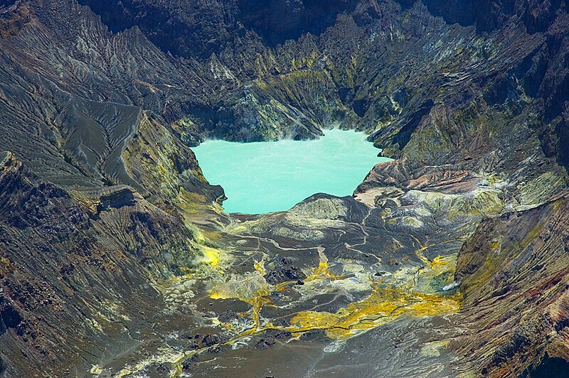
Main vent of Whakaari/White Island in 2000  Wikipedia.org

..........
 Volcano ActivityNew ZealandBay of Plenty, [White Island Volcano]Damage levelDetails
..........

Description
Recent monitoring of White Island in the Bay of Plenty suggests a slight increase in volcanic unrest, GNS Science says. Scientists measured an increase of carbon dioxide in the gas emitted at the largest accessible steam vent on October 1. These subtle changes also coincided with the presence of volcanic tremor and more elevated amounts of sulphur dioxide gas being emitted from the volcano, a statement from GNS said this morning. This indicated that unrest at White Island might have increased slightly in recent weeks. GNS geochemists sampled the largest accessible steam vent on October 1, which indicated a small increase in the temperature to 170C and an increase in the amount of carbon dioxide gas. These are consistent with the other gas measurements made at White Island. Volcanic tremor is a common type of volcanic earthquake activity recorded on the island. Since October 8, this has been increasing in strength and become "banded". Banded tremor is common at White Island and many active volcanoes worldwide. It has been recorded during increasing unrest and a variety of eruptive periods in the past. "During visits to the island in October, GeoNet staff also sampled and measured the lake temperature (54C) and it remains similar to other recent measurements," GNS said. "However, the lake level has risen about two metres since June. Since the lake re-established in late 2013 we have measured a rise of about 6m." The Volcanic Alert Level remains at Level 1 (minor volcanic unrest). "The changes we are seeing presently are common for the island," GNS said. "Activity may continue to increase or die away. Typical volcanic unrest hazards like hot ground and gas remain. A range of activity can occur under these conditions with little or no useful warning." GNS Science is continuing to closely monitor the activity at White Island and other New Zealand volcanoes through the GeoNet project.
..........

Aerial view of the crater lake in 2005  Wikipedia.org

..........
Otago Daily Times

Slight rise in volcano's activity

 
White Island off the Bay of Plenty. Photo: Wikimedia Commons
Recent monitoring of White Island in the Bay of Plenty suggests a slight increase in volcanic unrest, GNS Science says.Scientists measured an increase of carbon dioxide in the gas emitted at the largest accessible steam vent on October 1.
These subtle changes also coincided with the presence of volcanic tremor and more elevated amounts of sulphur dioxide gas being emitted from the volcano, a statement from GNS said this morning.
This indicated that unrest at White Island might have increased slightly in recent weeks.
GNS geochemists sampled the largest accessible steam vent on October 1, which indicated a small increase in the temperature to 170C and an increase in the amount of carbon dioxide gas. These are consistent with the other gas measurements made at White Island.


Read More Here
..........

Wednesday, October 14, 2015

The Tungurahua volcano shot out several bursts of gas and ash over the weekend


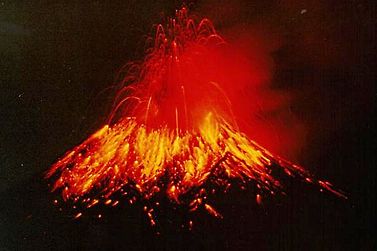
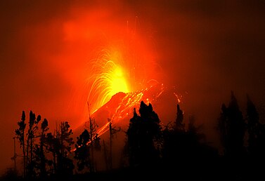
Tungurahua spews hot lava and ash at night (1999), As of July 2015 Tungurahua Volcano is still active and is under constant monitoring by EPN Geophysics Institute, National Polytechnic School.  Wikipedia.org


Tungurahua at night as of July 2015 a constant monitoring by E.P.N. Geophysics Institute..Wikipedia.org
............................................................................................

NZ Herald

Second volcano spews ash near Ecuador capital


QUITO, Ecuador (AP) " A second volcano is once again spewing plumes of ash in the mountain chain near Ecuador's capital.

The country's Geophysics Institute says the Tungurahua volcano shot out several bursts of gas and ash over the weekend, with one reaching more than a mile (about 2 kilometers) above 16,475-foot (5,023-meter) summit. It also hurled incandescent rock onto its slope.


Read More Here

Friday, October 9, 2015

Signs Of Change 2015 Part 6 September | Devastating Deluge

..........

Thursday, October 8, 2015

Volcano Activity - Ecuador, Pichincha : Cotopaxi, [Volcano Cotopaxi]

..........
Fox News

New bursts of ash and gas rise from Ecuador's Cotopaxi volcano

  • APTOPIX Ecuador Volcano-1.jpg
    A large plume of ash and steam rises from the Cotopaxi volcano as seen from Quito, Ecuador, Thursday, Oct. 8, 2015. The Geophysics Institute said during the first week of October the Cotopaxi has shown an increase in emission of ash and temperature, and a noted glow in the crater. (AP Photo/Dolores Ochoa) (The Associated Press)

Ecuador's restive Cotopaxi volcano has been spewing plumes of ash and gas far above its crater and volcanologists say its activity has been on the upswing.
..........


Volcano Activity Ecuador Pichincha / Cotopaxi, [Volcano Cotopaxi] Damage level Details
..........

RSOE EDIS Event Report

Event Description

Volcano Activity in Ecuador on Thursday, 08 October, 2015 at 19:23 (07:23 PM) UTC.
Description
Ecuador's Cotopaxi volcano, which began erupting in August after being dormant for 138 years, on Thursday coughed up a two-kilometer-high column of ash, officials said. The giant ash column was visible from Quito, 45 kilometers (30 miles) to the north of the volcano, considered one of the world's most dangerous because its snow cap is vulnerable in an eruption and because of its close proximity to densely populated areas. Ecuador's security coordination ministry said ash rose 2,000 meters above the volcano's crater, and warned some could fall on Quito's southern neighborhoods. Cotopaxi, one of eight active volcanoes in Ecuador, last erupted in 1877. The government declared a state of emergency in August after the volcano roared to life and has been conducting evacuation drills among the population. An estimated 325,000 people could be affected if the eruption triggers mudslides and avalanches, according to the authorities.

..........


Volcano Eruption in Guatemala Volcán de Fuego


..........
Volcán de Fuego
Volcan de Fuego October 1974 eruption.jpg
Volcán de Fuego, 1974 eruption. via Wikipedia.org
Elevation3,763 m (12,346 ft)
..........

RSOE EDIS
Event Report

 Volcano EruptionGuatemalaSierra Madre, [Volcan de Fuego]Damage levelDetails
..........
Description
The Volcan de Fuego (Fire Volcano( of Guatemala registered Wednesday its 8th eruption in this year, and keeps itself expelling gases and ashes to more than 4,800 meters of altitude over sea level. A communique by the National Seismology and Volcanology Institute gave information on the implementation of the yellow alert in the region and called the population to keep informed on the situation. Also, it recommended the authorities of the aeronautics to take precautions with the air traffic, since the ash column can increase in the next hours. The colossus with 1,300 meters high, as he warned the National Coordinating committee for the Reduction of Disasters, can increase the energy in the next hours and there is probability to generate ardent clouds that may descend on its skirts. For the time being it is not necessary to realize evacuations, said the entity.
..........
Base data
EDIS Number:VE-20151008-50410-GTM
Event type:Volcano Eruption
Date/Time:Thursday, 08 October, 2015 at 03:16 (03:16 AM) UTC
Last update:---
Cause of event: 
Damage level:Minor Damage level
Geographic information
Continent:Central-America
Country:Guatemala
County / State:Sierra Madre
Area:Volcan de Fuego
City: 
Coordinate:N 19° 33.800, W 103° 36.500
Number of affected people / Humanities loss
Foreign people:Affected is unknown.
..........


Sunday, September 27, 2015

More activity seen at the Colima Volcano


......................
 
 
The area highlighted in yellow is the most susceptible to ash fall from the Colima Volcano  The area highlighted in yellow is the most susceptible to ash fall. civil protection
News

More activity seen at the Colima Volcano

Watch out for falling rocks, particularly if they're hot, warns Civil Protection
 
The Colima Volcano continues to be active, sending a 1,500-meter column of smoke skyward at 7:08 this morning.
Civil Protection’s national coordinator, Luis Felipe Puente Espinosa, reported the eruption on his Twitter account, advising that the smoke, with a low ash content, was moving southwest.
The ash expelled by the volcano consists of material less than two millimeters in diameter and moves with the wind. But rock projectiles from the Volcano of Fire, as it is also known, are a different matter.
 
They can be up to 50 millimeters in diameter and are sent shooting out of the crater at high speed, before falling to the ground. This volcanic material can cause damage and injuries in populated areas, particularly if they are hot, which can result in fires.

Read More Here