Showing posts with label South America. Show all posts

Monday, November 30, 2015

Deadly kissing bugs reported in more than half of U.S., spreading Chagas disease


Daily News


NEW YORK DAILY NEWS
Updated: Wednesday, November 25, 2015, 11:58 AM
 

"Kissing Bug" now in Florida and Georgia
WTEV - Jacksonville, FL
 
Don't let the kissing bugs bite.
Here’s another reason to stay in New York this holiday season — the “kissing bug” has now spread to 28 states.

Texas is the latest to report an outbreak of infections from the Latin American triatomine bug after the pest had been spotted in other southern and western states, including Georgia, Alabama and California, according to the Centers for Disease Control and Prevention.

The creepy crawler resembling a cockroach gets its colorful nickname because it likes to bite around the lips and eyes of people when they are asleep. More than half of the bugs carry a parasite that can cause Chagas disease in humans, dogs and other mammals.

The good news? To actually pass on the disease, the bug not only needs to bite you, but then defecate into the gash. If left untreated, up to 30% of bite victims will develop chronic conditions such as difficulty breathing, heart and intestinal complications, and, in extreme cases, death.

There have been eight million cases in Latin America and South America because of poorly constructed rural homes, according to the CDC.

To prevent an outbreak, the CDC recommends:

Sealing cracks and gaps around windows, walls, roofs, and doors.
Removing wood, brush, and rock piles near your house.


Read More Here

Sunday, May 4, 2014

Chikungunya virus : mosquito-borne virus is rapidly spreading in the Caribbean . Currently more than 4,000 confirmed cases of the fast-spreading virus .


Newly arrived virus gains foothold in Caribbean


Associated Press


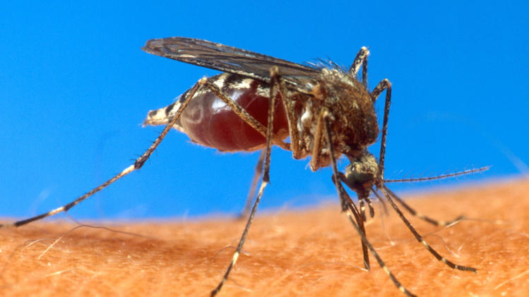
FILE- In this undated file photo provided byt he USDA, an aedes aegypti mosquito is shown on human skin. Health officials in the Dominican Republic said this Tuesday April 29, 1014, that the mosquito-borne chikungunya virus has spread widely since making its first appearance in the country. According to the Centers for Disease Control the chikungunya virus is most often spread to people by Aedes aegypti and Aedes albopictus mosquitoes. These are the same mosquitoes that transmit dengue virus. They bite mostly during the daytime. (AP Photo/USDA, File)
.
View photo

FILE- In this undated file photo provided byt he USDA, an aedes aegypti mosquito is shown on human skin. Health officials in the Dominican Republic said this Tuesday April 29, 1014, that the mosquito-borne chikungunya virus has spread widely since making its first appearance in the country. According to the Centers for Disease Control the chikungunya virus is most often spread to people by Aedes aegypti and Aedes albopictus mosquitoes. These are the same mosquitoes that transmit dengue virus. They bite mostly during the daytime. (AP Photo/USDA, File)

...
KINGSTON, Jamaica (AP) — A recently arrived mosquito-borne virus that causes an abrupt onset of high fever and intense joint pain is rapidly gaining a foothold in many spots of the Caribbean, health experts said Thursday.
There are currently more than 4,000 confirmed cases of the fast-spreading chikungunya virus in the Caribbean, most of them in the French Caribbean islands of Martinique, Guadeloupe and St. Martin. Another 31,000 suspected cases have been reported across the region of scattered islands.
The often painful illness most commonly found in Asia and Africa was first detected in December in tiny St. Martin. It was the first time that local transmission of chikungunya had been reported in the Americas. Since then, it has spread to nearly a dozen other islands and French Guiana, an overseas department of France on the north shoulder of South America.

Read More Here
Enhanced by Zemanta

Sunday, April 6, 2014

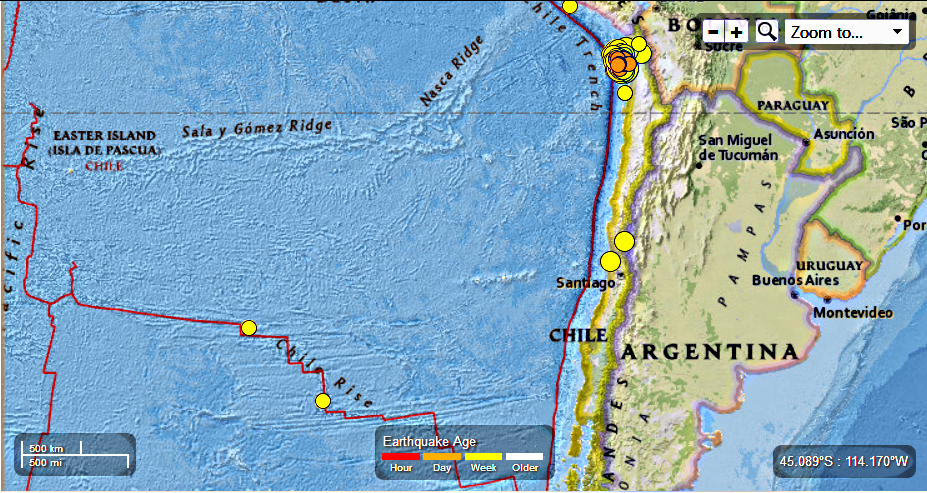
Chile : 98 Earthquakes Ranging in Magnitude from 8.2 to 4.5 in the last 7 days, 4/05/2014

Earth Watch Report  -  Earthquakes


Chile - 147 EQs in the  last 7 days .  4.5.2014 photo Chile147EQinthelast7days452014_zpsef523ec4.png

98 earthquakes in map area

  1. M 4.8 - 76km W of Iquique, Chile

     2014-04-05 09:04:49 UTC-05:00 10.0 km

  2. M 4.6 - 68km W of Iquique, Chile

     2014-04-05 06:58:25 UTC-05:00 10.0 km

  3. M 4.6 - 12km SE of Iquique, Chile

     2014-04-05 03:16:32 UTC-05:00 49.8 km

  4. M 4.7 - 77km WNW of Iquique, Chile

     2014-04-05 02:54:19 UTC-05:00 12.5 km

  5. M 4.6 - 15km WSW of Iquique, Chile

     2014-04-05 02:01:28 UTC-05:00 36.0 km

  6. M 4.8 - 81km W of Iquique, Chile

     2014-04-05 01:32:09 UTC-05:00 9.9 km

  7. M 5.3 - 33km WNW of Iquique, Chile

     2014-04-05 00:44:55 UTC-05:00 19.0 km

  8. M 4.7 - 73km SW of Iquique, Chile

     2014-04-05 00:28:57 UTC-05:00 17.7 km

  9. M 5.0 - 62km SW of Iquique, Chile

     2014-04-04 23:08:58 UTC-05:00 32.5 km

  10. M 4.8 - 83km SW of Iquique, Chile

     2014-04-04 23:05:03 UTC-05:00 22.9 km

  11. M 5.4 - 17km WNW of Hacienda La Calera, Chile

     2014-04-04 21:22:38 UTC-05:00 32.2 km

  12. M 5.0 - 44km WNW of Iquique, Chile

     2014-04-04 19:33:57 UTC-05:00 25.3 km

  13. M 4.6 - 75km WNW of Iquique, Chile

     2014-04-04 13:07:34 UTC-05:00 18.6 km

  14. M 4.9 - 77km WSW of Iquique, Chile

     2014-04-04 11:02:41 UTC-05:00 10.0 km

  15. M 4.8 - 89km WNW of Iquique, Chile

     2014-04-04 10:21:00 UTC-05:00 19.7 km

  16. M 5.2 - 70km SW of Iquique, Chile

     2014-04-04 04:53:26 UTC-05:00 17.6 km

  17. M 5.4 - 65km ENE of Salamanca, Chile

     2014-04-04 04:52:08 UTC-05:00 94.5 km

  18. M 5.1 - 91km WNW of Iquique, Chile

     2014-04-04 04:38:55 UTC-05:00 13.1 km

  19. M 4.7 - West Chile Rise

     2014-04-04 03:53:56 UTC-05:00 10.0 km

  20. M 4.6 - 84km WSW of Iquique, Chile

     2014-04-04 02:10:28 UTC-05:00 17.9 km

  21. M 4.5 - 88km WSW of Iquique, Chile

     2014-04-04 01:06:31 UTC-05:00 22.2 km

  22. M 4.7 - 15km SW of Tocopilla, Chile

     2014-04-03 23:34:28 UTC-05:00 59.5 km

  23. M 4.7 - 71km SW of Iquique, Chile

     2014-04-03 22:18:38 UTC-05:00 18.6 km

  24. M 6.1 - 76km SW of Iquique, Chile

     2014-04-03 20:37:51 UTC-05:00 20.0 km

  25. M 4.9 - 56km W of Iquique, Chile

     2014-04-03 18:37:51 UTC-05:00 23.5 km

  26. M 5.1 - 72km WSW of Iquique, Chile

     2014-04-03 13:56:12 UTC-05:00 10.0 km

  27. M 4.9 - 90km WSW of Iquique, Chile

     2014-04-03 10:08:06 UTC-05:00 1.0 km

  28. M 5.2 - 99km WSW of Iquique, Chile

     2014-04-03 09:34:05 UTC-05:00 11.7 km

  29. M 4.6 - 51km SSW of Iquique, Chile

     2014-04-03 06:50:47 UTC-05:00 29.8 km

  30. M 5.1 - 105km W of Iquique, Chile

     2014-04-03 06:41:35 UTC-05:00 10.6 km

  31. M 4.9 - 89km WSW of Iquique, Chile

     2014-04-03 04:47:57 UTC-05:00 10.1 km

  32. M 5.6 - 69km WSW of Iquique, Chile

     2014-04-03 04:23:21 UTC-05:00 14.9 km

  33. M 5.0 - 33km W of Iquique, Chile

     2014-04-03 04:08:58 UTC-05:00 26.1 km

  34. M 4.7 - 61km WSW of Iquique, Chile

     2014-04-03 03:44:04 UTC-05:00 22.8 km

  35. M 4.8 - 96km WNW of Iquique, Chile

     2014-04-03 03:28:51 UTC-05:00 14.6 km

  36. 4.8 77km W of Iquique, Chile 2014-04-03 02:38:15 UTC-05:00 26.7 km

  37. 4.9 73km SW of Iquique, Chile 2014-04-03 01:54:31 UTC-05:00 17.8 km

  38. 4.9 91km SSE of Putre, Chile 2014-04-03 01:16:08 UTC-05:00 103.0 km

  39. 5.5 66km SSW of Iquique, Chile 2014-04-03 00:51:44 UTC-05:00 26.9 km

  40. 5.2 54km WSW of Iquique, Chile 2014-04-03 00:34:32 UTC-05:00 20.9 km

  41. 6.2 77km SSW of Iquique, Chile 2014-04-03 00:26:16 UTC-05:00 24.3 km

  42. 4.8 94km WNW of Iquique, Chile 2014-04-03 00:17:11 UTC-05:00 16.6 km

  43. 4.9 81km SW of Iquique, Chile 2014-04-02 23:53:37 UTC-05:00 10.0 km

  44. 5.2 82km WSW of Iquique, Chile 2014-04-02 23:17:57 UTC-05:00 18.2 km

  45. 4.5 50km WSW of Iquique, Chile 2014-04-02 23:04:45 UTC-05:00 20.0 km

  46. 5.1 77km WNW of Iquique, Chile 2014-04-02 22:45:55 UTC-05:00 21.3 km

  47. 4.9 79km SW of Iquique, Chile 2014-04-02 22:40:32 UTC-05:00 31.5 km

  48. 5.8 76km SW of Iquique, Chile 2014-04-02 22:11:14 UTC-05:00 10.0 km

  49. 5.6 71km SW of Iquique, Chile 2014-04-02 21:56:06 UTC-05:00 16.7 km

  50. 7.7 49km SW of Iquique, Chile 2014-04-02 21:43:14 UTC-05:00 31.1 km

  51. 4.9 86km W of Iquique, Chile 2014-04-02 21:41:14 UTC-05:00 14.7 km

  52. 6.5 43km W of Iquique, Chile 2014-04-02 20:58:31 UTC-05:00 22.8 km

  53. 5.1 120km WNW of Iquique, Chile 2014-04-02 19:01:16 UTC-05:00 19.0 km

  54. 4.8 51km WSW of Iquique, Chile 2014-04-02 16:23:50 UTC-05:00 22.8 km

  55. 4.6 90km WNW of Iquique, Chile 2014-04-02 15:42:49 UTC-05:00 17.6 km

  56. 4.6 154km WNW of Iquique, Chile 2014-04-02 15:34:38 UTC-05:00 13.5 km

  57. 5.1 45km WSW of Iquique, Chile 2014-04-02 14:45:50 UTC-05:00 24.2 km

  58. 4.5 87km WNW of Iquique, Chile 2014-04-02 13:56:53 UTC-05:00 13.0 km

  59. 4.9 52km NNW of Iquique, Chile 2014-04-02 12:12:31 UTC-05:00 36.2 km

  60. 4.5 82km NW of Iquique, Chile 2014-04-02 10:44:02 UTC-05:00 20.0 km

  61. 4.5 71km NW of Iquique, Chile 2014-04-02 08:00:58 UTC-05:00 22.7 km

  62. 5.1 85km WNW of Iquique, Chile 2014-04-02 06:11:35 UTC-05:00 16.5 km

  63. 5.4 92km WNW of Iquique, Chile 2014-04-02 06:07:30 UTC-05:00 10.0 km

  64. 5.0 75km W of Iquique, Chile 2014-04-02 03:25:50 UTC-05:00 10.0 km

  65. 5.1 27km WNW of Iquique, Chile 2014-04-02 02:03:40 UTC-05:00 10.0 km

  66. 5.2 77km W of Iquique, Chile 2014-04-02 01:29:15 UTC-05:00 10.0 km

  67. 5.1 70km NNW of Iquique, Chile 2014-04-02 01:04:10 UTC-05:00 10.0 km

  68. 5.0 93km WNW of Iquique, Chile 2014-04-02 00:51:00 UTC-05:00 10.0 km

  69. 4.7 55km WSW of Iquique, Chile 2014-04-02 00:09:19 UTC-05:00 10.0 km

  70. 5.0 115km WNW of Iquique, Chile 2014-04-02 00:02:49 UTC-05:00 10.0 km

  71. 5.8 74km W of Iquique, Chile 2014-04-01 23:46:18 UTC-05:00 10.0 km

  72. 5.1 93km WNW of Iquique, Chile 2014-04-01 23:19:48 UTC-05:00 10.0 km

  73. 4.9 82km WNW of Iquique, Chile 2014-04-01 23:16:10 UTC-05:00 10.0 km

  74. 4.9 88km NW of Iquique, Chile 2014-04-01 23:13:07 UTC-05:00 10.0 km

  75. 4.7 94km NNW of Iquique, Chile 2014-04-01 22:51:02 UTC-05:00 10.0 km

  76. 5.2 89km WNW of Iquique, Chile 2014-04-01 22:40:16 UTC-05:00 10.0 km

  77. 4.5 38km W of Iquique, Chile 2014-04-01 22:20:45 UTC-05:00 10.0 km

  78. 5.0 108km SSW of Arica, Chile 2014-04-01 21:52:25 UTC-05:00 10.0 km

  79. 4.9 100km WNW of Iquique, Chile 2014-04-01 21:32:47 UTC-05:00 10.0 km

  80. 4.8 113km SSW of Arica, Chile 2014-04-01 21:27:18 UTC-05:00 10.0 km

  81. 4.9 76km W of Iquique, Chile 2014-04-01 20:35:47 UTC-05:00 10.0 km

  82. 4.8 97km SSW of Arica, Chile 2014-04-01 20:33:56 UTC-05:00 10.0 km

  83. 5.2 75km WNW of Iquique, Chile 2014-04-01 20:29:41 UTC-05:00 10.0 km

  84. 4.7 64km WNW of Iquique, Chile 2014-04-01 20:22:55 UTC-05:00 10.0 km

  85. 5.3 111km NW of Iquique, Chile 2014-04-01 20:20:58 UTC-05:00 10.0 km

  86. 4.7 59km NW of Iquique, Chile 2014-04-01 19:57:50 UTC-05:00 32.8 km

  87. 5.4 46km WNW of Iquique, Chile 2014-04-01 19:37:49 UTC-05:00 21.5 km

  88. 5.5 56km W of Iquique, Chile 2014-04-01 19:33:45 UTC-05:00 12.6 km

  89. 5.6 70km WNW of Iquique, Chile 2014-04-01 19:24:45 UTC-05:00 10.0 km

  90. 5.7 95km NW of Iquique, Chile 2014-04-01 19:06:44 UTC-05:00 10.0 km

  91. 5.8 87km WNW of Iquique, Chile 2014-04-01 19:03:12 UTC-05:00 10.0 km

  92. 6.2 88km N of Iquique, Chile 2014-04-01 18:58:00 UTC-05:00 18.1 km

  93. 5.2 51km WNW of Iquique, Chile 2014-04-01 18:57:32 UTC-05:00 28.1 km

  94. 5.2 93km NW of Iquique, Chile 2014-04-01 18:56:47 UTC-05:00 10.0 km

  95. 8.2 95km NW of Iquique, Chile 2014-04-01 18:46:46 UTC-05:00 20.1 km

  96. 4.5 63km NW of Iquique, Chile 2014-03-31 18:58:04 UTC-05:00 24.0 km

  97. 5.6 127km NE of Iquique, Chile 2014-03-31 07:53:05 UTC-05:00 112.1 km

  98. 4.6 West Chile Rise 2014-03-30 01:02:38 UTC-05:00 10.0 km


.....

M 8.2 - 95km NW of Iquique, Chile


Instrumental Intensity

ShakeMap Intensity Image

.....

M 7.7 - 49km SW of Iquique, Chile


Instrumental Intensity

ShakeMap Intensity Image
.....

M 6.5 - 43km W of Iquique, Chile


Instrumental Intensity

ShakeMap Intensity Image
.....


New earthquake in Chile prompts tsunami alerts

SANTIAGO Thu Apr 3, 2014 12:36am EDT
(Reuters) - A powerful 7.6-magnitude earthquake struck off northern Chile late on Wednesday, prompting tsunami alerts and evacuations along the coast and in neighboring Peru.
It was the strongest of several aftershocks that followed a huge 8.2-magnitude quake blamed for six deaths in the region on Tuesday.
There were no initial reports of serious damage but President Michelle Bachelet, who had gone to the area to inspect the damage from the earlier quake, was evacuated from her hotel in the city of Arica, local media reported.

Read More Here


.....

Deadly 8.2 Earthquake Displaces Thousands in Chile


.....


.....


Enhanced by Zemanta

Thursday, January 23, 2014

Mimosa Plants Have Long Term Memory, Can Learn, Biologists Say


Jan 16, 2014 by Sci-News.com

By using the same experimental framework normally applied to test learnt behavioral responses in animals, biologists from Australia and Italy have successfully demonstrated that Mimosa pudica – an exotic herb native to South America and Central America – can learn and remember just as well as it would be expected of animals.
Mimosa pudica at the Botanical Garden KIT, Karlsruhe, Germany. Image credit: H. Zell / CC BY-SA 3.0.
Mimosa pudica is known as the Sensitive plant or a touch-me-not. Dr Monica Gagliano from the University of Western Australia and her colleagues designed their experiments as if Mimosa was indeed an animal.
They trained Mimosa‘s short- and long-term memories under both high and low-light environments by repeatedly dropping water on them using a custom-designed apparatus.
The scientists show how Mimosa plants stopped closing their leaves when they learnt that the repeated disturbance had no real damaging consequence.
The plants were able to acquire the learnt behavior in a matter of seconds and as in animals, learning was faster in less favorable environment.
Most remarkably, these plants were able to remember what had been learned for several weeks, even after environmental conditions had changed.


Read More Here
Enhanced by Zemanta

Monday, November 25, 2013

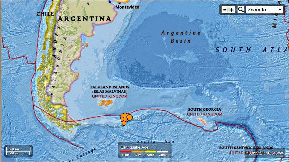
South Atlantic Ocean : 7.0 Magnitude Earthquake November 25th 2013

 Earth Watch Report  -  Earthquakes


South Atlantic Ocean  7.0 mag EQ November  25th  2013 photo SouthAtlanticOcean70magEQNovember25th2013_zpsc6660818.jpg

7 earthquakes in map area

  1. M 4.6 - South Atlantic Ocean

    2013-11-25 02:37:41 UTC-06:00 10.0 km

  2. M 4.6 - South Atlantic Ocean

    2013-11-25 01:56:10 UTC-06:00 10.0 km

  3. M 5.5 - South Atlantic Ocean

    2013-11-25 01:21:18 UTC-06:00 10.0 km

  4. M 5.4 - Falkland Islands region

    2013-11-25 00:41:50 UTC-06:00 14.3 km

  5. M 7.0 - South Atlantic Ocean

    2013-11-25 00:27:33 UTC-06:00 10.0 km

  6. M 5.6 - South Atlantic Ocean

    2013-11-25 00:27:09 UTC-06:00 11.9 km

  7. M 5.6 - South Atlantic Ocean

    2013-11-24 23:10:09 UTC-06:00 14.9 km


..........

M 7.0 - South Atlantic Ocean

 2013-11-25 06:27:33 UTC

Earthquake location 53.881°S, 54.882°W

Event Time

  1. 2013-11-25 06:27:33 UTC
  2. 2013-11-25 02:27:33 UTC-04:00 at epicenter
  3. 2013-11-25 00:27:33 UTC-06:00 system time

Location

53.881°S 54.882°W depth=10.0km (6.2mi)

Nearby Cities

  1. 314km (195mi) SE of Stanley, Falkland Islands
  2. 877km (545mi) E of Ushuaia, Argentina
  3. 998km (620mi) ESE of Rio Gallegos, Argentina
  4. 1031km (641mi) SE of Puerto Deseado, Argentina
  5. 314km (195mi) SE of Stanley, Falkland Islands
.........

Additional Commentary

The November 25, 2013 M7.0 earthquake (06:27:33 UTC) southwest of the Falkland Islands in the South Atlantic Ocean occurred as the result of strike slip faulting, on either a left-lateral fault striking ENE-WSW, or a right-lateral structure striking NNW-SSE.  The location of the earthquake, near the ENE-WSW trending plate boundary between the South America and Scotia tectonic plates, suggests it is likely associated with left-lateral faulting along this margin. At the location of this earthquake, the Scotia plate moves ENE with respect to South America at a rate of approximately 9.5 mm/yr.
The November 25, 06:27:33 earthquake was the largest of 5 M5+ events that occurred in a similar area over an approximate 2-hour period, including a M5.6 earthquake 24 seconds prior to the M7.0 mainshock. Though this region experiences moderate-sized earthquakes relatively frequently – 15 M5+ events have occurred within 250 km of the November 25 earthquake over the past 40 years – large events are fairly uncommon. The largest nearby earthquake over the same time period was a M6.6 event in September 1993, 210 km to the east of the November 25 earthquake.
..........

Magnitude-7.0 earthquake strikes South Atlantic near Falkland Islands; follows four other large quakes


BUENOS AIRES, Argentina - The U.S. Geological Survey says a magnitude-7.0 earthquake has struck in the South Atlantic, southwest of the disputed Falkland Islands.
It says the quake struck at 2:27 a.m. Monday (0627 GMT), about 195 miles (314 miles) southeast of the Falklands' capital, Stanley, and 545 miles east of Ushuaia, Argentina. The depth was a shallow 6.2 miles (10 kilometres).
Enhanced by Zemanta

Thursday, September 26, 2013

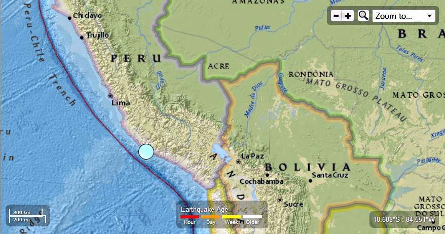
Peru - 7.0 Magnitude Earthquake - 50km S of Acari


Earth Watch Report  -  Earthquakes

 photo Peru-70MagEQ9252013_zpsd341c297.jpg
...

M 7.0 - 50km S of Acari, Peru

 2013-09-25 16:42:42 UTC


Earthquake location 15.882°S, 74.543°W
...

Event Time

  1. 2013-09-25 16:42:42 UTC
  2. 2013-09-25 11:42:42 UTC-05:00 at epicenter
  3. 2013-09-25 11:42:42 UTC-05:00 system time

Location

15.882°S 74.543°W depth=40.0km (24.9mi)

Nearby Cities

  1. 50km (31mi) S of Acari, Peru
  2. 95km (59mi) SE of Minas de Marcona, Peru
  3. 123km (76mi) SSE of Nazca, Peru
  4. 137km (85mi) SSW of Puquio, Peru
  5. 502km (312mi) SSE of Lima, Peru
...

Tectonic Summary

The Peru earthquake of September 25, 2013, occurred as thrust-faulting on or near the thrust-interface at the boundary between the South America plate and the subducting Nazca plate.  The Nazca plate subducts beneath the South America plate at the Peru-Chile trench offshore of western South America, and the thrust interface between the two plates dips east-northeast beneath the South American continent.   At the latitude of the earthquake, the Nazca plate moves to the east-northeast with respect to the South America plate with a velocity of about 70 mm/y.
The boundary-region between the Nazca and South American plates experiences a large number of earthquakes.  The region within 250 km of the epicenter of the earthquake of September 25 had experienced seventeen previous earthquakes of magnitude 6 and larger since 1973.  The largest of these, the magnitude 8.4 earthquake of June 23, 2001, occurred along the plate boundary to the south.  It killed at least 74 people and destroyed over 17,000 homes.  The magnitude 7.7 earthquake of November 12, 1996, killed at least 14 people and left 12,000 homeless.  It occurred along the plate boundary to the north of the September 25 epicenter.

Seismotectonics of South America (Nazca Plate Region)

The South American arc extends over 7,000 km, from the Chilean margin triple junction offshore of southern Chile to its intersection with the Panama fracture zone, offshore of the southern coast of Panama in Central America. It marks the plate boundary between the subducting Nazca plate and the South America plate, where the oceanic crust and lithosphere of the Nazca plate begin their descent into the mantle beneath South America. The convergence associated with this subduction process is responsible for the uplift of the Andes Mountains, and for the active volcanic chain present along much of this deformation front. Relative to a fixed South America plate, the Nazca plate moves slightly north of eastwards at a rate varying from approximately 80 mm/yr in the south to approximately 65 mm/yr in the north. Although the rate of subduction varies little along the entire arc, there are complex changes in the geologic processes along the subduction zone that dramatically influence volcanic activity, crustal deformation, earthquake generation and occurrence all along the western edge of South America.
Most of the large earthquakes in South America are constrained to shallow depths of 0 to 70 km resulting from both crustal and interplate deformation. Crustal earthquakes result from deformation and mountain building in the overriding South America plate and generate earthquakes as deep as approximately 50 km. Interplate earthquakes occur due to slip along the dipping interface between the Nazca and the South American plates. Interplate earthquakes in this region are frequent and often large, and occur between the depths of approximately 10 and 60 km. Since 1900, numerous magnitude 8 or larger earthquakes have occurred on this subduction zone interface that were followed by devastating tsunamis, including the 1960 M9.5 earthquake in southern Chile, the largest instrumentally recorded earthquake in the world. Other notable shallow tsunami-generating earthquakes include the 1906 M8.5 earthquake near Esmeraldas, Ecuador, the 1922 M8.5 earthquake near Coquimbo, Chile, the 2001 M8.4 Arequipa, Peru earthquake, the 2007 M8.0 earthquake near Pisco, Peru, and the 2010 M8.8 Maule, Chile earthquake located just north of the 1960 event.
Large intermediate-depth earthquakes (those occurring between depths of approximately 70 and 300 km) are relatively limited in size and spatial extent in South America, and occur within the Nazca plate as a result of internal deformation within the subducting plate. These earthquakes generally cluster beneath northern Chile and southwestern Bolivia, and to a lesser extent beneath northern Peru and southern Ecuador, with depths between 110 and 130 km. Most of these earthquakes occur adjacent to the bend in the coastline between Peru and Chile. The most recent large intermediate-depth earthquake in this region was the 2005 M7.8 Tarapaca, Chile earthquake.
Earthquakes can also be generated to depths greater than 600 km as a result of continued internal deformation of the subducting Nazca plate. Deep-focus earthquakes in South America are not observed from a depth range of approximately 300 to 500 km. Instead, deep earthquakes in this region occur at depths of 500 to 650 km and are concentrated into two zones: one that runs beneath the Peru-Brazil border and another that extends from central Bolivia to central Argentina. These earthquakes generally do not exhibit large magnitudes. An exception to this was the 1994 Bolivian earthquake in northwestern Bolivia. This M8.2 earthquake occurred at a depth of 631 km, making it the largest deep-focus earthquake instrumentally recorded, and was felt widely throughout South and North America.
Subduction of the Nazca plate is geometrically complex and impacts the geology and seismicity of the western edge of South America. The intermediate-depth regions of the subducting Nazca plate can be segmented into five sections based on their angle of subduction beneath the South America plate. Three segments are characterized by steeply dipping subduction; the other two by near-horizontal subduction. The Nazca plate beneath northern Ecuador, southern Peru to northern Chile, and southern Chile descend into the mantle at angles of 25° to 30°. In contrast, the slab beneath southern Ecuador to central Peru, and under central Chile, is subducting at a shallow angle of approximately 10° or less. In these regions of “flat-slab” subduction, the Nazca plate moves horizontally for several hundred kilometers before continuing its descent into the mantle, and is shadowed by an extended zone of crustal seismicity in the overlying South America plate. Although the South America plate exhibits a chain of active volcanism resulting from the subduction and partial melting of the Nazca oceanic lithosphere along most of the arc, these regions of inferred shallow subduction correlate with an absence of volcanic activity.
More information on regional seismicity and tectonics
...

Instrumental Intensity

ShakeMap Intensity Image
...
 photo Peru-70MagEQ9252013_zps539e543e.jpg
...

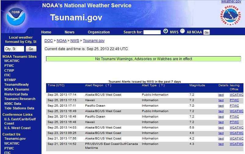
Tsunami warning after 7.0 earthquake off Peru coast

Published time: September 25, 2013 18:00
Edited time: September 25, 2013 20:09
A picture released by the Peruvian Andina agency shows people gathering in an open space in front of an office complex in Lima, during an earthquake of magnitude 7.0 which struck off Peru's southern coast (AFP Photo)

Some homes crumbled and a tsunami warning was issued after a 7.0 earthquake struck just off Peru’s southern coast. The impact caused buildings in the Peruvian capital, Lima, to shake, despite the city being 480 kilometers away.
Earthquakes of this size sometimes generate local tsunamis that can be destructive along coasts located within 100 kilometers of the earthquake epicenters,” the Pacific Tsunami Warning Center said in a statement. The center advised authorities to act appropriately.
The quake struck just 80 kilometers from the nearest Peruvian city, Acari, according to the US Geological Survey, with its epicenter at a depth of 33 kilometers. The quake had originally been measured at a magnitude of 6.8.
While no deaths or injuries were immediately reported, homes in the province of Caraveli in Arequipa crumbled in the shock.


Read More Here


...
Enhanced by Zemanta