
NBC News Science
Scott Olson / Getty Images
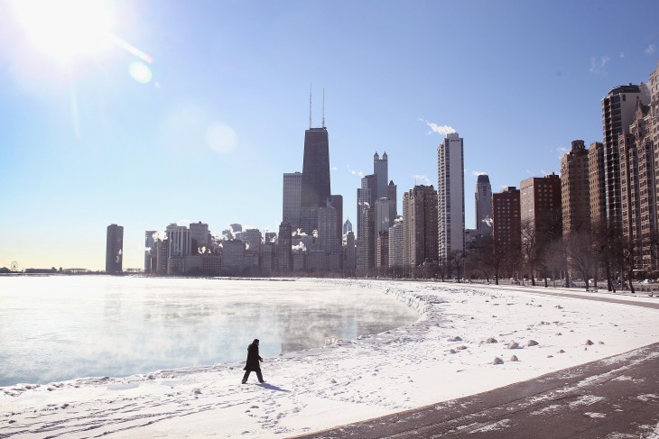
The Chicago skyline rises above the icy edge of Lake Michigan on
Monday. The Midwest has been especially hard-hit by winter weather this
month.
"A lot of this is connected," said Brian Fuchs, a climatologist at the National Drought Mitigation Center in Lincoln, Neb. "As we're seeing, the warmth and dryness in the West has implications all the way up to Alaska and also in areas to the east."
The long-lasting ridge causes a kink in the jet stream, sending warm marine air from the Pacific up into Alaska and bringing cold Arctic air down into America's heartland.
The effects are brutal: Midwesterners and Easterners already have suffered through a couple of cold waves, and this week's big chill is disrupting air travel and spreading misery across a region stretching from Texas to Minnesota to the Carolinas. Meanwhile, Alaska's thaw has triggered a mammoth avalanche, cutting off road access to the port of Valdez and stoking fears of flash floods.
Worries in the WestThe locked-in ridge is having a more insidious effect on the West. Precipitation has been scarce — so scarce that there's a drought emergency in California and wildfire warnings in Oregon. In January!
Is it possible that this year's drought and fire season will be even worse than last year's? "The current water year, which started in October, is one of the driest on record that we've ever seen," Fuchs told NBC News. "Even if we had near-record moisture from here on out, it would still be tough to make up the deficit."
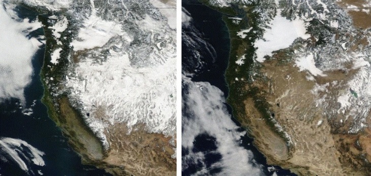
NASA via Cliff Mass
Two pictures from NASA's Aqua satellite tell the tale for this year's
drought conditions in the western United States. The photo at left is
Jan. 20, 2013. The photo at right is from Jan. 20, 2014. "Wow ... what a
difference," says Cliff Mass, a weather researcher at the University of
Washington.
Read More and Watch Video Here
Related articles


No comments:
Post a Comment
Hello and thank you for visiting my blog. Please share your thoughts and leave a comment :)