Monday, September 30, 2013

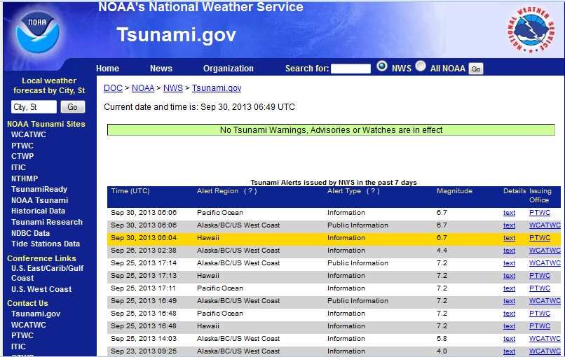
New Zealand - 6.7 Magnitude Earthquake - 81km NE of L'Esperance Rock

Earth Watch Report  -  Earthquakes
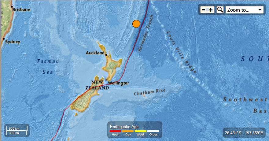

 photo NewZealand-67magEQ9302013_zpseae26fc0.jpg
...

M 6.7 - 81km NE of L'Esperance Rock, New Zealand

 2013-09-30 05:55:54 UTC


Earthquake location 30.956°S, 178.244°W

Event Time

  1. 2013-09-30 05:55:54 UTC
  2. 2013-09-29 17:55:54 UTC-12:00 at epicenter
  3. 2013-09-30 00:55:54 UTC-05:00 system time

Location

30.956°S 178.244°W depth=34.8km (21.6mi)

Nearby Cities

  1. 81km (50mi) NE of L'Esperance Rock, New Zealand
  2. 870km (541mi) NE of Whangarei, New Zealand
  3. 891km (554mi) NNE of Whakatane, New Zealand
  4. 906km (563mi) NE of Tauranga, New Zealand
  5. 1129km (702mi) SSW of Nuku`alofa, Tonga
...

Instrumental Intensity

ShakeMap Intensity Image
...

Tectonic Summary

Seismotectonics of the Eastern Margin of the Australia Plate

The eastern margin of the Australia plate is one of the most sesimically active areas of the world due to high rates of convergence between the Australia and Pacific plates. In the region of New Zealand, the 3000 km long Australia-Pacific plate boundary extends from south of Macquarie Island to the southern Kermadec Island chain. It includes an oceanic transform (the Macquarie Ridge), two oppositely verging subduction zones (Puysegur and Hikurangi), and a transpressive continental transform, the Alpine Fault through South Island, New Zealand.
Since 1900 there have been 15 M7.5+ earthquakes recorded near New Zealand. Nine of these, and the four largest, occurred along or near the Macquarie Ridge, including the 1989 M8.2 event on the ridge itself, and the 2004 M8.1 event 200 km to the west of the plate boundary, reflecting intraplate deformation. The largest recorded earthquake in New Zealand itself was the 1931 M7.8 Hawke's Bay earthquake, which killed 256 people. The last M7.5+ earthquake along the Alpine Fault was 170 years ago; studies of the faults' strain accumulation suggest that similar events are likely to occur again.
North of New Zealand, the Australia-Pacific boundary stretches east of Tonga and Fiji to 250 km south of Samoa. For 2,200 km the trench is approximately linear, and includes two segments where old (>120 Myr) Pacific oceanic lithosphere rapidly subducts westward (Kermadec and Tonga). At the northern end of the Tonga trench, the boundary curves sharply westward and changes along a 700 km-long segment from trench-normal subduction, to oblique subduction, to a left lateral transform-like structure.
Australia-Pacific convergence rates increase northward from 60 mm/yr at the southern Kermadec trench to 90 mm/yr at the northern Tonga trench; however, significant back arc extension (or equivalently, slab rollback) causes the consumption rate of subducting Pacific lithosphere to be much faster. The spreading rate in the Havre trough, west of the Kermadec trench, increases northward from 8 to 20 mm/yr. The southern tip of this spreading center is propagating into the North Island of New Zealand, rifting it apart. In the southern Lau Basin, west of the Tonga trench, the spreading rate increases northward from 60 to 90 mm/yr, and in the northern Lau Basin, multiple spreading centers result in an extension rate as high as 160 mm/yr. The overall subduction velocity of the Pacific plate is the vector sum of Australia-Pacific velocity and back arc spreading velocity: thus it increases northward along the Kermadec trench from 70 to 100 mm/yr, and along the Tonga trench from 150 to 240 mm/yr.
The Kermadec-Tonga subduction zone generates many large earthquakes on the interface between the descending Pacific and overriding Australia plates, within the two plates themselves and, less frequently, near the outer rise of the Pacific plate east of the trench. Since 1900, 40 M7.5+ earthquakes have been recorded, mostly north of 30°S. However, it is unclear whether any of the few historic M8+ events that have occurred close to the plate boundary were underthrusting events on the plate interface, or were intraplate earthquakes. On September 29, 2009, one of the largest normal fault (outer rise) earthquakes ever recorded (M8.1) occurred south of Samoa, 40 km east of the Tonga trench, generating a tsunami that killed at least 180 people.
Across the North Fiji Basin and to the west of the Vanuatu Islands, the Australia plate again subducts eastwards beneath the Pacific, at the North New Hebrides trench. At the southern end of this trench, east of the Loyalty Islands, the plate boundary curves east into an oceanic transform-like structure analogous to the one north of Tonga.
Australia-Pacific convergence rates increase northward from 80 to 90 mm/yr along the North New Hebrides trench, but the Australia plate consumption rate is increased by extension in the back arc and in the North Fiji Basin. Back arc spreading occurs at a rate of 50 mm/yr along most of the subduction zone, except near ~15°S, where the D'Entrecasteaux ridge intersects the trench and causes localized compression of 50 mm/yr in the back arc. Therefore, the Australia plate subduction velocity ranges from 120 mm/yr at the southern end of the North New Hebrides trench, to 40 mm/yr at the D'Entrecasteaux ridge-trench intersection, to 170 mm/yr at the northern end of the trench.
Large earthquakes are common along the North New Hebrides trench and have mechanisms associated with subduction tectonics, though occasional strike slip earthquakes occur near the subduction of the D'Entrecasteaux ridge. Within the subduction zone 34 M7.5+ earthquakes have been recorded since 1900. On October 7, 2009, a large interplate thrust fault earthquake (M7.6) in the northern North New Hebrides subduction zone was followed 15 minutes later by an even larger interplate event (M7.8) 60 km to the north. It is likely that the first event triggered the second of the so-called earthquake "doublet".
More information on regional seismicity and tectonics
...
 photo NewZealand-67magEQ9302013_zpsb083ec20.jpg
....
Enhanced by Zemanta

3 New Islands Form in Arabian Sea Following 7.7 Pakistan Earthquake!

Published on Sep 27, 2013
 
It will be interesting to see what another large quake might bring...Minus the casulties :(

**********************************************************************
IndiaVision - An Informative Site on India

Pakistan gets three new islands

Thursday - Sep 26, 2013, 06:15pm (GMT+5.5)
New Delhi - Pakistan has just got three brand new islands -- thanks to a major earthquake.
When the shock of the temblor subsided Tuesday, people living in the coastal town of Gwadar were stunned to see a new island in the sea.
That's not all. Two other islands have come up along the Balochistan coast.
"The island near Gwadar is about 600 feet in diameter and has a height of about 30 feet," Muhammad Moazzam Khan, technical advisor at WWF - Pakistan, told IANS over telephone.
He said "gas was coming out" of the island, which primarily consists of "stones and soft mud".
The two islands near Ormara town are small.
Khan said the islands had a diameter of about "30-40 feet and a height of about 2-3 feet".
"Gas is also coming out," he said.
He said that while some islands which form suddenly "stay on", others gradually fade away.
He explained that the islands were formed following the massive earthquake that rocked Balochistan province Tuesday.
The death toll in the 7.7-magnitude earthquake has reached 348, and a total of 20,000 houses were destroyed.
This is not the first time islands have formed off the Pakistan coast.
"In 1945, two big islands had formed near the coast. One was two kilometers long while the other was 1/2 km long," said Khan.
By Rahul Dass


***********************************************************************


Enhanced by Zemanta

Saturday, September 28, 2013

Pakistan : 7.7 Mag Earthquake 's death toll rises to 348. Mysterious Island (mud volcano) draws speculation

People walk on an island.
A magnitude 7.7 earthquake struck a remote part of Pakistan with enough force to create a small island.
Photograph from Gwadar Government/AP

Brian Clark Howard
Published September 25, 2013

On Tuesday, a 7.7-magnitude earthquake struck a remote part of western Pakistan, killing more than 260 people and displacing hundreds of thousands. It also triggered formation of a new island off the coast, which has quickly become a global curiosity.
But scientists say the island won't last long.
"It's a transient feature," said Bill Barnhart, a research geophysicist with the U.S. Geological Survey. "It will probably be gone within a couple of months. It's just a big pile of mud that was on the seafloor that got pushed up."
Indeed, such islands are formed by so-called mud volcanoes, which occur around the world, and Barnhart and other scientists suspect that's what we're seeing off the Pakistani coast.
News organizations have reported that the Pakistani island suddenly appeared near the port of Gwadar after the quake. The island is about 60 to 70 feet (18 to 21 meters) high, up to 300 feet (91 meters) wide, and up to 120 feet (37 meters) long, reports the AFP.
Media reports have located the new island at just a few paces to up to two kilometers off the coast of Pakistan. It is about 250 miles (400 kilometers) from the epicenter of the earthquake.
Map by National Geographic maps.
The island appears to be primarily made out of mud from the seafloor, although photos show rocks as well, Barnhart told National Geographic. He has has been studying images and media accounts of the new island from his lab in Golden, Colorado.
"It brought up a dead octopus, and people have been picking up fish on [the island]," he said.
A similar mud island appeared off Pakistan after a 2011 earthquake there, Barnhart said: "It lasted a month or two and then washed away."
How Mud Volcanoes Work
Though mud volcanoes have been seen elsewhere, they don't always produce islands.
Such volcanoes were seen in California after a 2010 earthquake, Barnhart noted, when the tremors caused carbon dioxide to bubble up through the ground, but the result was "vigorous boiling," not new islands.
Barnhart said Pakistani scientists will soon be measuring the new landmass to better understand how it formed.
People walk along the island that emerged after a 7.7 magnitude earthquake struck a remote part of Pakistan.

 Read More Here

****************************************************************

A Bird’s Eye View of Earth’s Newest Island


This island was created off the coast of Gwadar when Pakistan was hit by a 7.8-magnitude earthquake on Sept. 24, 2013.  Imagery collected on Sept. 26, 2013.
DigitalGlobe / Getty ImagesThis island was created off the coast of Gwadar when Pakistan was hit by a 7.8-magnitude earthquake on Sept. 24, 2013. Imagery collected on Sept. 26, 2013.

***************************************************************

SHAKE AND BLOW

Pakistan quake island unlikely to last: experts


by Staff Writers
Gwadar, Pakistan (AFP) Sept 25, 2013
A small island of mud and rock created by the huge earthquake that hit southwest Pakistan has fascinated locals but experts -- who found methane gas rising from it -- say it is unlikely to last long.
The 7.7-magnitude quake struck on Tuesday in Baluchistan's remote Awaran district, killing at least 271 people and affecting hundreds of thousands.
Off the coastline near the port of Gwadar, some 400 kilometres (250 miles) from the epicentre, locals were astonished to see the dark grey mass of rock and mud that had emerged from the waves in the Arabian Sea.
"It is not a small thing, but a huge thing which has emerged from under the water," Gwadar resident Muhammad Rustam told AFP.
"It looked very, very strange to me and also a bit scary because suddenly a huge thing has emerged from the water."
Enterprising boat owners were doing a brisk trade ferrying curious sightseers to the island -- dubbed "Earthquake Mountain" by locals.
Mohammad Danish, a marine biologist from Pakistan's National Institute of Oceanography, said a team of experts had visited the island and found methane gas rising.
"Our team found bubbles rising from the surface of the island which caught fire when a match was lit and we forbade our team to start any flame. It is methane gas," Danish said on GEO television news.
The island is about 60 to 70 feet (18 to 21 metres) high, up to 300 feet wide and up to 120 feet long, he said. It sits about 650 feet from the coast.
The surface was a solid but muddy mix of stones, sand and water with visible cracks, said an AFP cameraman who visited the island. Dead fish and sea plants lay on the surface.
Gary Gibson, a seismologist with Australia's University of Melbourne, said the new island was likely to be a "mud volcano", created by methane gas forcing material upwards during the violent shaking of the earthquake.
"It's happened before in that area but it's certainly an unusual event, very rare," Gibson told AFP, adding that it was "very curious" to see such activity some 400 kilometres from the quake's epicentre.
The so-called island is not a fixed structure but a body of mud that will be broken down by wave activity and dispersed over time, the scientist said.


Read More Here


***************************************************************
Enhanced by Zemanta

Pakistan earthquake death toll rises as rescuers struggle to help injured


Provincial official puts death toll from magnitude 7.7 quake in Awaran district in Baluchistan at 210, with 375 people injured
  • theguardian.com, Wednesday 25 September 2013 03.06 EDT
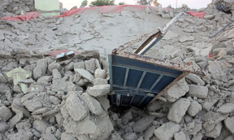
The rubble of a house in Awaran district after the magnitude 7.7 earthquake in Pakistan
The rubble of a house after the magnitude 7.7 earthquake struck in Awaran district, Baluchistan province, Pakistan. Photograph: Stringer/Pakistan/Reuters
 
Rescuers are struggling to help thousands of people injured and left homeless after their houses collapsed in a massive earthquake in south-western Pakistan as the death toll rose to 210, officials said.
The magnitude 7.7 quake struck in the remote district of Awaran in Pakistan's Baluchistan province on Tuesday afternoon. Such a quake is considered major, capable of widespread and heavy damage.
The tremors were felt as far away as New Delhi, the Indian capital, some 740 miles (1,200km) away.
A provincial official, Zahid bin Maqsood, put the death toll at 210 and said 375 people had been injured, while a spokesman for the provincial government, Jan Mohammad Bulaidi, put the death toll at 216 – the conflicting figures likely to be due to the difficulty in contacting local officials and people in the remote region.
In the densely populated city of Karachi on the Arabian Sea and Quetta, the capital of Baluchistan province, people ran into the streets in panic when the quake it, praying for their lives.-


Read More Here


*************************************************************


Pakistanis struggle for food, shelter after quake


AP
Quetta, Pakistan, September 26, 2013


First Published: 10:26 IST(26/9/2013)
Last Updated: 15:44 IST(26/9/2013)
Hungry survivors dug through rubble to find food and thousands slept under the open sky or in makeshift shelters for a second night as the death toll from Pakistan's massive earthquake rose to 348 on Thursday.
Rescuers battled to reach remote areas of the impoverished region in
the wake of Tuesday's magnitude 7.7 quake in southwestern Baluchistan province.
The quake had flattened wide swathes of Awaran district where it was centered, leaving much of the population homeless.
The spokesman for the provincial government, Jan Mohammad Bulaidi, said 348 people have been confirmed dead so far and 552 people had been injured.
"We need more tents, more medicine and more food," Bulaidi said earlier.
In the village of Dalbadi, almost all of the 300 mud-brick homes were destroyed. Noor Ahmad said he was working when the quake struck and rushed home to find his house leveled and his wife and son dead.
"I'm broken," he said. "I have lost my family."
Doctors in the village treated some of the injured, but due to a scarcity of medicine and staff, they were mostly seen comforting the survivors.
Awaran district is one of the poorest in the country's most impoverished province. Many people use four-wheel-drive vehicles and camels to traverse the rough terrain.


Read More Here


*************************************************************

Big Pond

Pakistan earthquake toll reaches 328


Thursday, September 26, 2013 » 06:32am


The death toll from a 7.7-magnitude earthquake that hit southwestern Pakistan on Tuesday has risen to 328.

Desperate villagers in southwest Pakistan are clawing through the wreckage of their ruined homes, a day after a huge earthquake struck, killing more than 300 people.
The 7.7-magnitude quake hit on Tuesday afternoon in Baluchistan province's remote and Awaran district.
At least 328 people have been confirmed dead and more than 450 injured, according to the Provincial Disaster Management Authority (PDMA) and the Baluchistan government.
In the village of Dalbedi, the earthquake - Pakistan's deadliest since the devastating Kashmir quake of 2005, which killed 73,000 - flattened some 250 houses.
Bewildered villagers dug with their hands through the rubble of their mud houses in Dalbedi to retrieve what was left of their meagre possessions.
Their simple houses destroyed, they used rags, old clothes, sheets and tree branches to shelter their families from the sun.
Farmer Noor Ahmed, 45, said the tremors lasted for two minutes and turned buildings in the village into piles of mud.
'We have lost everything, even our food is now buried under mud, and water from underground channels is now undrinkable because of excessive mud in it due to the earthquake,' he told AFP.


Read More Here


*************************************************************
Enhanced by Zemanta