
The Lufkin News
High winds blow train cars off trestle across Lufkin's north loop
Section of loop expected to remain closed Monday
Derailed

Straight-line winds this morning blew rail cars off the railroad trestle — and their own wheels — across North John Redditt Drive, near the Pepsi plant on Lufkin's north loop. The loop is closed from state Highway 103 west to U.S. 69 north.
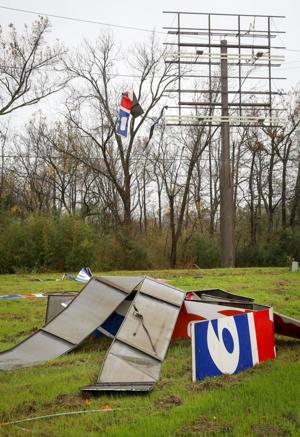
Billboard down
Sunday morning's straight-line winds that blew railroad cars off a trestle across Loop 287 near U.S. 69 north also destroyed a couple of billboards at that intersection, sending debris into nearby trees and power lines.
Straight-line
winds on Sunday morning blew rail cars off the railroad trestle across
Lufkin's north loop, near the Pepsi plant and U.S. Highway 69 north.
Texas Department of Transportation officials said Sunday afternoon that they expected that section of the loop to remain closed for some or all of today as they clear the rail cars and repair the highway.
Two rail cars fell to the roadway beneath the railroad bridge. Dozens other rail cars came off the track, as well. A&NR Railroad owns and operates the railroad from which the cars were derailed.
Motorist Jose Torres posted this on The Lufkin News' Facebook page on Sunday morning: "I got there right after it happened and you could hear the metal clanking as it was still slightly falling. No cars were pinned and noone looked to be injured. The train is always stationary at that location so no train operators seemed to have been injured either."
Barricades will remain in place and motorists will be detoured until the roadway is cleared, according to Rhonda Oaks, public information officer for the Lufkin District. Residents with direct access as well as businesses within the barricaded area will be accommodated to and from their locations, she said.
“Removing the rail cars in the safest way possible will require certain things to happen,” Oaks said. “Our officials have devised a traffic control plan for motorists until the cars can be removed, and we are hoping that will be by Monday evening. We are waiting on equipment that is being sent from Houston before the cleanup can begin.”
Read More HereTexas Department of Transportation officials said Sunday afternoon that they expected that section of the loop to remain closed for some or all of today as they clear the rail cars and repair the highway.
Two rail cars fell to the roadway beneath the railroad bridge. Dozens other rail cars came off the track, as well. A&NR Railroad owns and operates the railroad from which the cars were derailed.
Motorist Jose Torres posted this on The Lufkin News' Facebook page on Sunday morning: "I got there right after it happened and you could hear the metal clanking as it was still slightly falling. No cars were pinned and noone looked to be injured. The train is always stationary at that location so no train operators seemed to have been injured either."
Barricades will remain in place and motorists will be detoured until the roadway is cleared, according to Rhonda Oaks, public information officer for the Lufkin District. Residents with direct access as well as businesses within the barricaded area will be accommodated to and from their locations, she said.
“Removing the rail cars in the safest way possible will require certain things to happen,” Oaks said. “Our officials have devised a traffic control plan for motorists until the cars can be removed, and we are hoping that will be by Monday evening. We are waiting on equipment that is being sent from Houston before the cleanup can begin.”
........................................................................................
Winds Blow Train Off Tracks In Lufkin, Texas
Posted: Dec 13, 2015 9:36 AM CST Updated: Dec 13, 2015 1:41 PM CST

Read More Here
......................................................................................................
Wikipedia.org
Straight-line winds
See also: Derecho
Straight-line winds may be damaging to marine interests. Small ships, cutters and sailboats are at risk from this meteorological phenomenon.
.......................
Derecho
From Wikipedia, the free encyclopedia
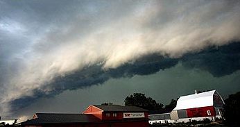
A shelf cloud along the leading edge of a derecho photographed in Minnesota
Derechos can cause hurricane force winds, tornadoes, heavy rains, and flash floods. Convection-induced winds take on a bow echo (backward "C") form of squall line, forming in an area of wind divergence in upper levels of the troposphere, within a region of low-level warm air advection and rich low-level moisture. They travel quickly in the direction of movement of their associated storms, similar to an outflow boundary (gust front), except that the wind is sustained and increases in strength behind the front, generally exceeding hurricane-force. A warm-weather phenomenon, derechos occur mostly in summer, especially during June, July, and August in the Northern Hemisphere, within areas of moderately strong instability and moderately strong vertical wind shear. They may occur at any time of the year and occur as frequently at night as during the daylight hours.
............................

WHAT ARE STRAIGHT-LINE WINDS?
METEOROLOGIST JEFF HABY
There are several terms that mean the same as straight-line winds and they are convective wind gusts, outflow and downbursts. Straight-line wind is wind that comes out of a thunderstorm. If these winds meet or exceed 58 miles per hours then the storm is classified as severe by the National Weather Service. These winds are produced by the downward momentum in the downdraft region of a thunderstorm. An environment conducive to strong straight-line wind is one in which the updrafts and thus downdrafts are strong, the air is dry in the middle troposphere and the storm has a fast forward motion.
A storm with a strong updraft will tend to have a strong downdraft. When the CAPE is very high then strong or severe convective wind gusts could occur. Dry air aloft will entrain into the downdraft. This promotes evaporative cooling and this further enhances the negative buoyancy of a parcel. A cold parcel of air surrounded by warm air will sink since the cold air is more dense. The colder the parcel is compared to the surrounding air then the faster it will sink. Dramatically cooler air is often noticed at the surface when the downburst air reaches the observer. When a storm has a fast forward motion the rate that the downdraft is moving is added to the storm motion. This can produce strong to severe winds out ahead of the storm as the storm approaches.
Read More Here
No comments:
Post a Comment
Hello and thank you for visiting my blog. Please share your thoughts and leave a comment :)