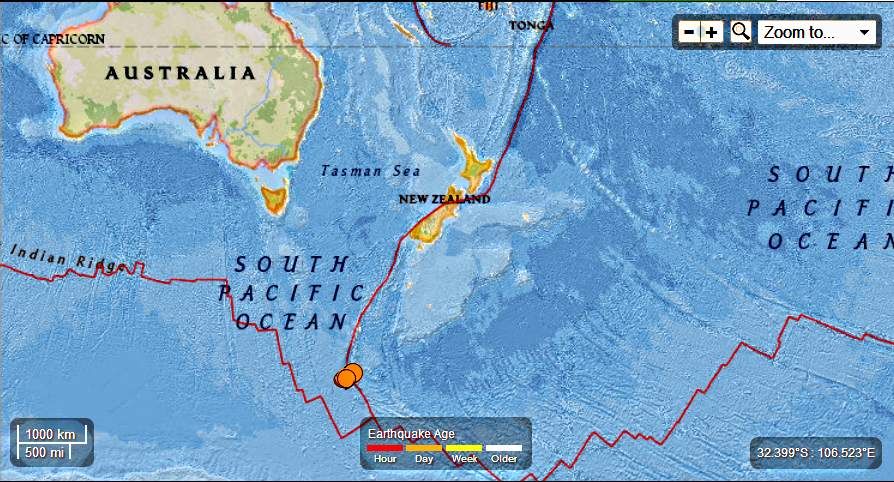
Earth Watch Report - Earthquakes

....
M5.7 - Macquarie Island region
2013-06-16 13:31:35 UTC

Event Time
- 2013-06-16 13:31:35 UTC
- 2013-06-17 00:31:35 UTC+11:00 at epicenter
- 2013-06-16 08:31:35 UTC-05:00 system time
Location
58.364°S 158.193°E depth=10.0km (6.2mi)Nearby Cities
- 434km (270mi) S of Macquarie Island, Australia
- 1496km (930mi) SSW of Invercargill, New Zealand
- 1545km (960mi) SSW of Gore, New Zealand
- 1619km (1006mi) SSW of Dunedin, New Zealand
- 1880km (1168mi) SSE of Hobart, Australia
....
M5.0 - Macquarie Island region
2013-06-16 14:20:03 UTC

Event Time
- 2013-06-16 14:20:03 UTC
- 2013-06-17 01:20:03 UTC+11:00 at epicenter
- 2013-06-16 09:20:03 UTC-05:00 system time
Location
58.256°S 158.315°E depth=15.2km (9.4mi)Nearby Cities
- 421km (262mi) S of Macquarie Island, Australia
- 1482km (921mi) SSW of Invercargill, New Zealand
- 1531km (951mi) SSW of Gore, New Zealand
- 1605km (997mi) SSW of Dunedin, New Zealand
- 1873km (1164mi) SSE of Hobart, Australia
Seismicity in Australia
INTRODUCTIONEarthquakes can occur in almost every part of Australia, although certain regions have a higher likelihood of experiencing an earthquake than others. Possibly the most earthquake prone regions of Australia are the West Australian wheatbelt, and the Flinders Ranges of South Australia. The alpine region of eastern Australia is also relatively active. Three Australian earthquakes are known to have caused fatalities. The 1902 earthquake near Warooka, on the Yorke Peninsula of South Australia (mag 6.0), caused two deaths, attributed to heart attacks. The 1935 Gayndah earthquake in Queensland caused one death. By far the most significant was the 1989 earthquake at Newcastle, NSW (mag 5.6), which caused 13 fatalities, mostly because of the catastrophic structural collapse of the Newcastle Worker's Club.
The body responsible for producing risk maps of Australia is the Australian Earthquake Engineering Society.
West Australian seismicity is treated separately on this site. Seismicity for the rest of Australia is summarised below.
BELOW - Map of earthquakes superimposed on Digital Terrain Model - courtesy Dan Clark, Geoscience Australia
-Below - Earthquake Hazard map of Australia, 1991 (Australian Geological Survey Organisation, Canberra: McCue et al., 1993). A new version of this map was published by Geoscience Australia in 2012.
This map shows that the coastal regions of NW Australia are the most earthquake prone, and the region of east Australia to the west of the dividing range is the least.
TABLE OF IMPORTANT AUSTRALIAN EARTHQUAKES
DATE
|
LOCATION
|
MAG
| Rank* | cost* |
COMMENTS
|
| 26 Jan 1892 | Bass St., Tas. | 6.9 | largest of a series of earthquakes | ||
| 10 May1897 | Beachport, SA | 6.5 | 7 | 12m | massive damage around Kingston, SA |
| 19 Sep1902 | Warooka, Yorke Peninsula, SA | 6.0 | 5 | 12m | two known deaths |
| 19 Nov 1906 | off west coast of WA | 7.5 | 111.8E , 19.1S -largest Australian earthquake? | ||
| 6 June 1918 | Gladstone, Qsld | 6.0 | one of largest E aust earthquakes, felt from Mackay to Grafton | ||
| 29 Apr 1941 | Meeberrie, WA | 7.3 | the biggest onshore Australian event | ||
| 27 June 1941 | Simpson Desert, NT | 6.5 | largest of a series of earthquakes | ||
| 3 Jan 1954 | Adelaide, SA | 5.4 | 2 | 152m | $8.8 million in damage (in 1954 $) |
| 22 May 1961 | Robertson/Bowral | 5.6 | $500,00 (in 1961 $) | ||
| 14 Oct 1968 | Meckering, WA | 6.8 | 4 | 57m | 35 km surface rupture |
| 2 June 1979 | Cadoux, WA | 6.2 | 6 | 16m | surface rupture |
| 30 March 1986 | Marryat Ck, SA | 5.8 | 14 km surface rupture, 0.6 m vertical offset | ||
| 22 Jan 1988 | Tennant Ck., NT | 6.7 | 3 events over mag 6 on this day | ||
| 28 Dec 1989 | Newcastle, NSW | 5.6 | 1 | 5.3Bn | 13 killed, $1.5 Billion damage |
| 8 Aug 1994 | Ellalong NSW | 5.4 | 3 | 71m | near Newcastle - $40 m damage |
| 20 Apr 2010 | Kalgoorlie | 5.0 | 8 | 3 people injured |
| = Although the Newcastle NSW earthquake of December 1989 was one of our most significant in terms of loss of life and damage, for sheer energy release, the activity which began in Tennant Creek, NT in January 1988, is probably more significant. Three magnitude 6 events occurred there within 24 hours, and complex surface rupturing occurred. Many thousands of aftershocks have occurred there since those events, and aftershocks are still occurring there. Since the Tennant Creek earthquakes, the largest Australian event has been the Mag 6.3 event off Cockatoo Is., northern WA, in August 1997. Between 2000 and 2002, a large swarm of earthquakes occurred near Burakin, WA. Burakin is approximately 200 km NE of Perth. Three earthquakes of magnitude 5.0 or more occurred in this earthquake swarm. Since the 1997 Cockatoo Is. event, the largest Australian earthquake has been the magnitude 5.4 earthquake at Mt. Redvers, N.T., near the West Australian border. It occurred on Feb 11 2004. The maps below were produced from extracts of the on-line data base of Geoscience Australia (www.ga.gov.au) |
....
Related articles
- Australia - 5.8 - Northern Territory, 2013-06-09 14:22:12 UTC (familysurvivalprotocol.com)
- Moderate earthquake - Macquarie Island Region on June 16, 2013 (earthquake-report.com)
- Moderate earthquake - Macquarie Island Region on May 21, 2013 (earthquake-report.com)
- 6.7 and 5.4 Magnitude Earthquakes - approx 176km ENE of Flying Fish Cove, Christmas Island 2013-06-13 16:47:23 UTC (familysurvivalprotocol.com)


No comments:
Post a Comment
Hello and thank you for visiting my blog. Please share your thoughts and leave a comment :)