
Earth Watch Report - Earthquakes

...
M 6.5 - 75km SW of Etchoropo, Mexico
2013-10-19 17:54:56 UTC

Event Time
- 2013-10-19 17:54:56 UTC
- 2013-10-19 10:54:56 UTC-07:00 at epicenter
- 2013-10-19 12:54:56 UTC-05:00 system time
Location
26.268°N 110.178°W depth=8.0km (5.0mi)Nearby Cities
- 75km (47mi) SW of Etchoropo, Mexico
- 82km (51mi) SW of Huatabampo, Mexico
- 100km (62mi) SSW of Villa Juarez, Mexico
- 106km (66mi) WNW of Ahome, Mexico
- 816km (507mi) SSE of Phoenix, Arizona
Tectonic Summary
Seismotectonics of Mexico
Located atop three of the large tectonic plates, Mexico is one of the world's most seismically active regions. The relative motion of these crustal plates causes frequent earthquakes and occasional volcanic eruptions. Most of the Mexican landmass is on the westward moving North American plate. The Pacific Ocean floor south of Mexico is being carried northeastward by the underlying Cocos plate. Because oceanic crust is relatively dense, when the Pacific Ocean floor encounters the lighter continental crust of the Mexican landmass, the ocean floor is subducted beneath the North American plate creating the deep Middle American trench along Mexico's southern coast. Also as a result of this convergence, the westward moving Mexico landmass is slowed and crumpled creating the mountain ranges of southern Mexico and earthquakes near Mexico's southern coast. As the oceanic crust is pulled downward, it melts; the molten material is then forced upward through weaknesses in the overlying continental crust. This process has created a region of volcanoes across south-central Mexico known as the Cordillera Neovolcánica.The area west of the Gulf of California, including Mexico's Baja California Peninsula, is moving northwestward with the Pacific plate at about 50 mm per year. Here, the Pacific and North American plates grind past each other creating strike-slip faulting, the southern extension of California's San Andreas fault. In the past, this relative plate motion pulled Baja California away from the coast forming the Gulf of California and is the cause of earthquakes in the Gulf of California region today.
Mexico has a long history of destructive earthquakes and volcanic eruptions. In September 1985, a magnitude 8.1 earthquake killed more than 9,500 people in Mexico City. In southern Mexico, Volcán de Colima and El Chichón erupted in 2005 and 1982, respectively. Paricutín volcano, west of Mexico City, began venting smoke in a cornfield in 1943; a decade later this new volcano had grown to a height of 424 meters. Popocatépetl and Ixtaccíhuatl volcanos ("smoking mountain" and "white lady", respectively), southeast of Mexico City, occasionally vent gas that can be clearly seen from the City, a reminder that volcanic activity is ongoing. In 1994 and 2000 Popocatépetl renewed its activity forcing the evacuation of nearby towns, causing seismologists and government officials to be concerned about the effect a large-scale eruption might have on the heavily populated region. Popocatépetl volcano last erupted in 2010.
More information on regional seismicity and tectonics

...
6.5 magnitude earthquake strikes off Mexico coast
Published time: October 19, 2013 18:11
Edited time: October 19, 2013 19:17
Edited time: October 19, 2013 19:17
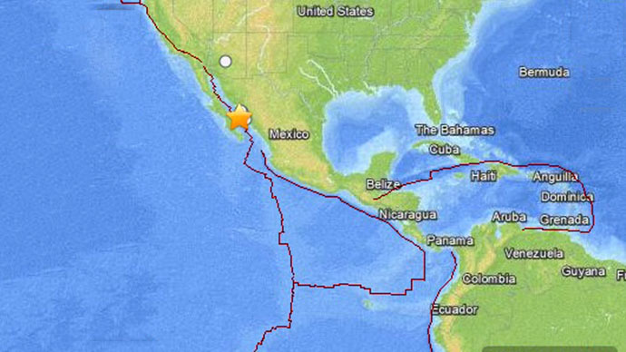
The epicenter of the quake was 10 kilometers deep in the Sea of Cortez. Emergency services in Mexican Sonora and Sinaloa states said there were no immediate reports of casualties and it was not yet clear how the quake had affected Baja California Sur.
The quake was initially reported to have reached a magnitude of 6.8, but was later downgraded to 6.5 by USGS.
A tsunami warning has not been issued.
Over 138,300 people live within 100 kilometers from the epicenter of the earthquake, according to the Global Disaster Alert and Coordination System (GDACS).
Read More Here
...
Related articles


