Showing posts with label Bureau of Land Management. Show all posts

Tuesday, September 22, 2015

2015 wildfire season a record-breaker


EarthSky

Worst recorded years for U.S. wildfires are 2005, 2006, 2007, 2011 and 2012. This year has already joined that list, and wildfire season is still going strong.


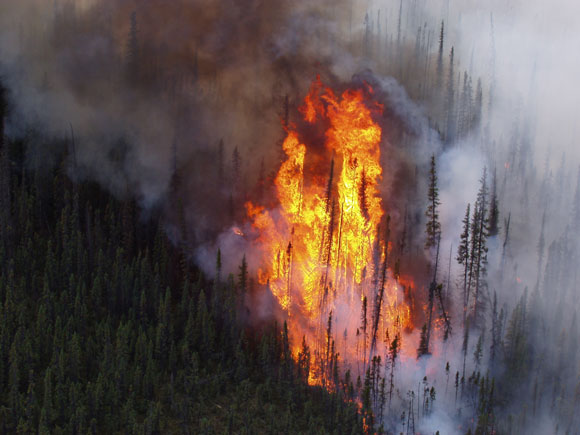
Trees engulfed in flames at the Tetlin National Wildlife Refuge in Alaska. Image Credit: U.S. Fish and Wildlife Service.
Trees engulfed in flames at the Tetlin National Wildlife Refuge in Alaska. Image via U.S. Fish and Wildlife Service.

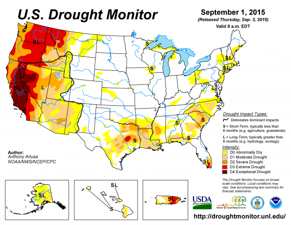
The ongoing drought in the U.S. West is not helping the wildfire situation in 2015.  Current info about 2015's drought in the U.S. here
The 2015 wildfire season in the United States has already broken records. So far this year, more acres of land have burned as of mid-September than the total annual amount in 2011, which was the 4th worst year for wildfires at least since the 1960s. So will this year be the new fourth worst, third worst, second worst, or worst wildfire year since then? Read on, and take a guess.
The National Interagency Fire Center in Boise, Idaho, publishes a ton of useful statistics on wildfires that are critical for helping state and federal agencies manage the flames. These records date back to the 1960s.
The chart below, created with the National Interagency Fire Center data, shows that the worst years for wildfires in the U.S., since these records began being kept, were 2006 (9,873,745 acres burned), 2007 (9,328,045 acres burned), 2012 (9,326,238 acres burned), 2011 (8,711,367 acres burned), and 2005 (8,689,389 acres burned).
Already as of September 18, 2015, 8,821,040 acres of land have burned across the U.S., and this number exceeds the total number of acres burned for 2011. Hence, 2015 has already earned a spot as the 4th worst year on record, and the 2015 wildfire season is still going strong.

Read More Here

Tuesday, April 8, 2014

Environment Pollution - State of Utah, [Little Valley Wash, Grand Staircase National Monument]

Earth Watch Report  -  Hazmat

"James
James Holland, hydrologist/geologist with the Kanab Field Office of the United States Bureau of Land Management, examines an oil-covered rock with the Forest Service's Joe Harris and BLM's Sarah Schlanger in Little Valley Wash in the Upper Valley region of Grand Staircase-Escalante National Monument
.....
April 01 2014 07:40 AMEnvironment PollutionUSAState of Utah, [Little Valley Wash, Grand Staircase National Monument]Damage levelDetails

.....
Description
Hikers exploring the Grand Staircase Escalante National Monument in Southern Utah last week happened upon an oil spill over four miles in length in an area known as Little Valley Wash. The spill is thought to be old, based on the dense, asphalt-like consistency of the oil, said Larry Crutchfield, Bureau of Land Management public affairs specialist. And it's a good thing the oil is so thick, he added, because that means the spill will stay put for a while. "The good news is that there is no oil actively moving in the wash," Crutchfield said. Because the oil in the wash is nearly as thick as asphalt, he added, it is not posing an immediate threat to surrounding areas. However, he said there is evidence suggesting it did move last September when massive monsoon rains created a violent flash flood in the wash. The area typically does receive some rain in the springtime, he said, but not nearly enough to fill the part of the wash where the oil is, which is far upstream. The BLM isn't taking any chances, however, and plans to secure the area with booms and other equipment to help protect monument resources and water sources. Although preliminary reports last week suggested the spill may have originated from a leak that occurred last month in a nearby pipeline operated by Citation Oil, Crutchfield said the oil found in the wash is very unlikely to have come from a recent leakage."The Citation oil line did spring a pinhole-sized leak," Crutchfield said. That leak spilled about 10 barrels of oil before it was discovered and patched last month. The oil that flows through the pipeline has a low viscosity and would be very fluid, he said �" not the thick, viscous, asphalt-like substance found in the wash. The oil in the wash appears to have been there for some time, he said. In fact, investigators currently suspect the spill had been buried beneath the wash until it was exposed by a violent flash flood last fall, which explains why the spill hadn't been reported in previous years. When asked who might have buried the spill, Crutchfield said it's quite possible that it was covered by sediment deposited by an earlier flood. There is no way of knowing for sure before BLM investigators complete their assessment of the incident. "We have an idea of where the oil may have come from, but it would be entirely inappropriate for me to speculate at this point," Crutchfield said. The first priority, he said, is to assess the danger that the oil poses to the surrounding environment. "The important thing at this stage is that we are taking action,” he said. “Citation Oil is taking action. We are working together to figure out what exactly happened."

.....

Sun Independent.com

Massive oil spill discovered at Grand Staircase National Monument


Monday, 03-31-2014, 08:30 PM
Written by Michael Flynn
Hikers exploring the Grand Staircase Escalante National Monument in Southern Utah last week happened upon an oil spill over four miles in length in an area known as Little Valley Wash.
The spill is thought to be old, based on the dense, asphalt-like consistency of the oil, said Larry Crutchfield, Bureau of Land Management public affairs specialist. And it's a good thing the oil is so thick, he added, because that means the spill will stay put for a while.
"The good news is that there is no oil actively moving in the wash," Crutchfield said. Because the oil in the wash is nearly as thick as asphalt, he added, it is not posing an immediate threat to surrounding areas. However, he said there is evidence suggesting it did move last September when massive monsoon rains created a violent flash flood in the wash.
The area typically does receive some rain in the springtime, he said, but not nearly enough to fill the part of the wash where the oil is, which is far upstream. The BLM isn't taking any chances, however, and plans to secure the area with booms and other equipment to help protect monument resources and water sources.

Read More Here

.....

Published: Friday, April 4 2014 7:46 p.m. MDT

James Holland, hydrologist/geologist with the Kanab Field Office of the federal Bureau of Land Management, left, points to asphalt-like patches of oil in Little Valley Wash in the Upper Valley region of Grand Staircase-Escalante National Monument near Escalante on Friday, April 4, 2014. Holland, along with Joe Harris of the Forest Service, Mark Bing, central regional manager of Citation Oil and Gas Corp., Terry Tolbert, wildlife biologist, and Julie Sueker of Arcadis Environmental Consulting Group, hiked the 4-mile stretch of the wash where the oil was discovered.
Laura Seitz, Deseret News

ESCALANTE, Garfield County — Remnants from at least one large oil spill found by hikers on March 23 in Grand Staircase-Escalante National Monument has officials wondering how and when the damage occurred.
As many as 4 miles in the Little Valley Wash now contain the aftermath of the spill, with about 1.5 miles of 6-inch thick oil flows contained in the mostly dry stream bed. Bureau of Land Management officials who manage the monument say it's likely the leak happened decades ago.
BLM officials hypothesize that the spill became encased in sediment deposits over time, making it difficult or impossible to see in most areas. Last September, intense floods washed down the drainage, possibly unburying the oil deposit and carrying parts of it downstream for 2.5 miles.
Boulders and tree trunks in the drainage now demonstrate the depth of the initial oil flows, with steady black lines as many as 2 feet above the stream bed. Black splotches are found in other areas, with vegetation collecting the oil as it flowed along with the flood waters.
Long stretches of oil patches not mixed with sediment have liquified in regions exposed to the sun.
"It's not what we want to see here," associate monument manager Sarah Schlanger said during an examination of the area Friday.

Read More Here

.....
Enhanced by Zemanta

Saturday, September 14, 2013

Mysterious Elk Deaths Plague New Mexico

Live Science


Elk at water tank
An elk gets a drink from a BLM watering hole.
Credit: Bureau of Land Management Colorado


Officials with the New Mexico Department of Game and Fish are puzzling over the mysterious deaths of more than 100 elk, apparently all within a 24-hour period, in rural New Mexico.
The elk were found Aug. 27 on a 75,000-acre ranch north of the city of Las Vegas.
Livestock deaths, by themselves, are not unusual — there are many things that can fell large animals, including predators, poachers, a natural or man-made toxin, disease, drought, heat, starvation, and even lightning. [Spooky! Top 10 Unexplained Phenomena]
But so far wildlife officials have seemingly ruled out most of these possibilities: The elk weren't shot (nor taken from the area), so it was not poachers. Tests have come back negative for anthrax, a bacteria that exists naturally in the region and can kill large animals. There seems to be no evidence of any heavy pesticide use in the area that might have played a role in the die-off.
Though lightning strikes are not uncommon in the Southwest and in New Mexico specifically, killing over 100 animals at one time would be an incredibly rare event. It might be an as-yet unidentified disease, though killing so many at once — and so quickly — would be very unusual. Another possibility is some sort of contamination of the well or water tanks, but so far no toxins have been identified.


Read More Here


Enhanced by Zemanta

Saturday, August 10, 2013

Forest / Wild Fire - State of Idaho, [Fall Creek region]

Earth Watch Report  -  Forest/Wild Fires


The Pony Complex is currently burning 52,000 acres near Mountain Home. The fires have closed roads and forced homeowners to evacuate Saturday.
INCIWEB


Read more here: http://www.idahostatesman.com/2013/08/10/2699149/mandatory-fire-evacuations-ordered.html#storylink=cpy
MOUNTAIN HOME -- The town of Prairie and the area of Fall Creek is now under a mandatory evacuation because of the Pony Complex Fire.
...
Forest / Wild FireUSAState of Idaho, [Fall Creek region]Damage level
 
Details
...

Forest / Wild Fire in USA on Saturday, 10 August, 2013 at 04:50 (04:50 AM) UTC.

Description
The town of Prairie and the area of Fall Creek is now under a mandatory evacuation because of the Pony Complex Fire. We are told residents can evacuate using Blacks Creek Road. A shelter is in place for evacuated residents. The Elmore County Sheriff's Office says evacuated residents can go to the Good Counsel Hall in Mountain Home. This wildfire is especially dangerous because of how fast it's moving. A 56-mile stretch of Highway 20 was closed most of the day from Mountain Home to Fairfield, but reopened around 3 p.m. Right now all the focus is on the town of Prairie and the area around it as the Pony Complex fire continues to inch closer and closer to homes. Our crew that was on the scene most of the day says the fire has burned to about one mile away from the town located about 50 miles east of Boise. Elmore County Sheriff's deputies are going door-to-door talking to homeowners and letting them know that they are under a mandatory evacuation order. Lightning started 11 fires overnight, forcing the closure of Highway 20 from the Pilot Truck Stop in Mountain Home to the Camas County line. Ten outbuildings and barns have been destroyed because of these fires that have burned 30,000 acres. The Pony Complex fire is estimated to cover about 39 square miles, stretching to the southwestern end of Anderson Ranch Reservoir. Many families trying to start vacations in the Sun Valley area were forced to turn around. Some saw the storms roll through last night and decided to stay in Mountain Home before trying to continue their trip. The Bureau of Land Management has 125 firefighters, 20 engines, eight dozers, six air tankers and a Type I and Type 2 management teams are on their way. Wind continues to be the biggest problem for firefighters. Large plumes of smoke can be seen billowing from the hillsides, make visibility very poor.
...

Mandatory fire evacuations ordered in Elmore County

Published: August 10, 2013 Updated 1 hour ago

The Pony Complex is currently burning 52,000 acres near Mountain Home. The fires have closed roads and forced homeowners to evacuate Saturday.
INCIWEB
Mayfield residents are being routed from their homes by a wildfire burning close to the town.
The Mudd Fire, part of the 52,000 acre Pony Complex that sparked during Thursday night’s lightning storm, is burning in the foothills above Mayfield, a Bureau of Land Management spokeswoman said Saturday.
Mallory Eils said that the town wasn’t immediately threatened by the blaze, but officials thought it was best to take precautions.About 200 residents have been evacuated. The fire is burning mostly on the Elmore County side, but officials are in contact with Ada County in case it spreads.
The area between Indian Creek Road, Mayfield Road, and Base Line Road is being evacuated now, she said. Evacuees are being directed to the Red Cross shelter at Good Council Hall in Mountain Home.

...

Highway 20 reopens, Idaho town evacuated due to wildfire


by KTVB.com
NWCN.com
Posted on August 9, 2013 at 5:26 PM

MOUNTAIN HOME -- The town of Prairie and the area of Fall Creek is now under a mandatory evacuation because of the Pony Complex Fire.
We are told residents can evacuate using Blacks Creek Road.
A shelter is in place for evacuated residents.  The Elmore County Sheriff's Office says evacuated residents can go to the Good Counsel Hall in Mountain Home.
This wildfire is especially dangerous because of how fast it's moving.
A 56-mile stretch of Highway 20 was closed most of the day from Mountain Home to Fairfield, but reopened around 3 p.m.
"The fire is growing with the wind and the terrain and they dry conditions and the heat," said Carrie Bilbao with the Boise BLM District.  "With the multiple starts and trying to get resources on them, it's been tough."
Right now all the focus is on the town of Prairie and the area around it as the Pony Complex fire continues to inch closer and closer to homes.  Our crew that was on the scene most of the day says the fire has burned to about one mile away from the town located about 50 miles east of Boise.

Read More and Watch Video Here
...
Enhanced by Zemanta

Thursday, June 13, 2013

Forest / Wild Fire - State of Colorado, [Black Forest] : A wildfire charged through the Black Forest area northeast of Colorado Springs, Colo. igniting several large houses

Earth Watch Report - Forest/Wild Fires

EVACUATING CATHEDRAL PINES IN BLACK FOREST FIRE!!!

GreggMonument
Published on Jun 11, 2013
Video of when fire first started and prior to mandatory evacuations in Cathedral Pines.

Black Forest Colorado Fire (Civilian Footage)

CurrentNewsTVx CurrentNewsTVx
 
Published on Jun 12, 2013
1st Video: Skyline loop in Canon City. (Aerial firefighting??)
2nd Video: Mandatory Evacuation Cathedral Pines

....
12.06.2013 Forest / Wild Fire USA State of Colorado, [Black Forest] Damage level Details
....

Forest / Wild Fire in USA on Wednesday, 12 June, 2013 at 03:11 (03:11 AM) UTC.

Description
A wildfire charged through the Black Forest area northeast of Colorado Springs, Colo., on Tuesday, igniting several large houses as its flames threatened a neighborhood set in dense forest where some home values top $1 million. A thick plume of gray smoke could be seen from Denver, about 65 miles to the north. Video from a helicopter showed flames engulfing several large homes. Homes in the Black Forest area are on sites between 2 to 5 acres each. Cathedral Pines, a neighborhood with several pricey homes with views of Pikes Peak, is among the areas evacuated because of the blaze. CBS Station KCNC Colorado reported that based on Copter 4's video, it looked like at least 10 homes were burned. Fire managers requested aerial firefighting resources, and the Air Force Academy was among those sending ground resources to help fight the flames. A U.S. Forest Service official in Golden, Mike Stearly, said an air tanker from Nevada will be coming to battle the blaze but is unsure when it will arrive. He told CBS4: "We are a little disconnected with the immediate information on ground, but we are focusing on the protection of people at this time. Things are hot and heavy here at the coordination center." There were no immediate reports of injuries in the Black Forest Fire, said Lt. Jeff Kramer of the El Paso County sheriff's department. He didn't know how many homes had been evacuated. Kramer said it was too soon to say what caused the blaze. He said residents were being notified to leave by automated phone calls and in some cases in-person visits from sheriff's deputies. "To protect life is certainly the ultimate priority here," Kramer said. The Black Forest Fire was one of at least three significant wildfires burning in Colorado amid gusty winds and record-breaking hot, dry weather. A fire burning on an estimated 300 acres south of the Royal Gorge Bridge and Arkansas River led to the evacuation of the Royal Gorge Bridge and Park near Canon City, the Bureau of Land Management said. Park spokeswoman Peggy Gair told The Gazette the evacuations affected several hundred people at the park, which closed Tuesday afternoon. Evacuations also were in effect from Parkdale to Soda Point, north of the Royal Gorge, the BLM said.
....

Colorado fires burn homes, force thousands to flee

Wildfires have burned 80 to 100 homes in Colorado Springs, and the sheriff said he feared there were fatalities.

BLACK FOREST, Colo. — Wildfires burning across Colorado Wednesday have destroyed dozens of homes and forced thousands to evacuate, including 900 inmates from a state prison. Near Colorado Springs, El Paso County Sheriff Terry Maketa said Wednesday afternoon that the Black Forest Fire had destroyed 92 homes. The cause was still unknown. Maketa said about 2,300 homes, affecting about 6,400 people, were evacuated, and 7,500 acres had burned since the fire began Tuesday. No injuries or deaths have been reported. Maketa said officials were trying to confirm the whereabouts of one person reported missing Wednesday. Firefighters tried to go where the person was last seen but were turned back twice because it was too hot, he said. Wildfires also were burning in New Mexico, Oregon and California, where a smokejumper was killed fighting one of dozens of lightning-sparked fires.


 Read Full Article Watch Videos Here