Showing posts with label Chicago. Show all posts

Thursday, February 20, 2014

More snow in New England, but trouble for others, too

MSN

More snow is ahead for residents of northern New England a day after a fast-moving storm dumped about a foot on many communities, but rain and warmer temperatures could present problems in other states.
A worker is reflected in a building facade as he clears snow from the sidewalk in Boston, Tuesday, Feb. 18, 2014. It was expected to drop 3 to 5 inches of snow on Boston, with 6 to 10 inches forecast for parts of Northern New England, before moving out late Tuesday and early Wednesday. (AP Photo | Michael Dwyer)
A worker is reflected in a building facade as he clears snow from the sidewalk in Boston, Tuesday, Feb. 18, 2014. It was expected to drop 3 to 5 inches of snow on Boston, with 6 to 10 inches forecast for parts of Northern New England, before moving out late Tuesday and early Wednesday. (AP Photo/Michael Dwyer)
CONCORD, N.H. (AP) — More snow is ahead for residents of northern New England a day after a fast-moving storm brought about a foot to many communities, but rain and warmer temperatures could present new problems for other states.
A rain and snow mixture is possible Wednesday along the northern New England coast, but inland communities could see between 1 and 4 inches of snow, said Eric Schwibs, a meteorologist with the National Weather Service in Gray, Maine.
That's far less than the 12 inches of snow reported Tuesday night in New Boston, N.H., or the nearly 10 inches that fell in Kennebunk, Maine. There were no immediate reports of any major traffic messes caused by the weather.
MSN Weather: Check your local weather forecast
MSN Weather: Rock salt supply at critical low
Elsewhere in the country, as warmer temperatures bring rain and melt snow, concerns are being raised about the potential for flooding and collapsing roofs.
In Chicago, the weather service says people who live along rivers and in flood prone areas should prepare for possible flooding as the mounds of snow in yards and along streets melt.


Read More Here
.....

NBC News

Flooding Woes are on Tap for Snow-Buried Midwest

Winter’s woes aren’t just about severe storms and bitter cold — there’s still freezing rain and melting snow to grapple with.
Nasty thunderstorms will target the Ohio Valley on Thursday and could bring an inch-and-a-half of rain and create extreme flooding conditions in parts of Indiana, Illinois, Michigan and Ohio, according to forecasts. A flood watch has been issued across Illinois.

“The great melt has started,” National Weather Service meteorologist Brian Hirsch told NBC News.
Aside from the rain, warmer temperatures are moving in, which will speed the melt. Chicago, for instance, could hit a high of 50 degrees Thursday, forecasts say. The Windy City endured a 52-day stretch of below-freezing temperatures this winter, keeping the the accumulated snow firmly in place.


.....
Enhanced by Zemanta

Saturday, December 28, 2013

H1N1 flu strikes Illinois; vaccine available


Friday, December 27, 2013
 
Flu viruses are spreading in Illinois and the leading strain detected in lab tests is H1N1, the same strain that caused a pandemic in 2009.
Health officials say statewide flu activity is "regional," which is a step below "widespread." That means the flu has been confirmed in less than half the regions of the state.
In Chicago, hospitals are reporting an increase in emergency room visit from people with flu-like symptoms. But levels are half what they were during the same week last season.
"It's been very quiet, very much in the background," Paul Schreckenberger, microbiologist, said of the strain. "Then all of the sudden this year, starting last week, we've had a big upsurge of the 2009 pandemic strain."

Read More Here
Enhanced by Zemanta

Tuesday, June 25, 2013

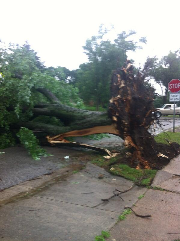
Power Outage - State of Nebraska, Omaha : A severe thunderstorm hit the Omaha metro area around 10 am packing 70 mph winds and heavy rain. About 5,000 customers are without electricity

Earth Watch Report  -  Power  Outage - Storms


See Additional Photos Here

....
25.06.2013Power OutageUSAState of Nebraska, OmahaDamage level Details
....

Power Outage in USA on Monday, 24 June, 2013 at 18:02 (06:02 PM) UTC.

Description
A severe thunderstorm hit the Omaha metro area around 10 am packing 70 mph winds and heavy rain. Those strong winds downed trees, power lines and caused outages throughout Douglas and Sarpy Counties. There are reports of trees down all over the city blocking streets and bringing down power lines. Omaha Fire Department units are busy responding to calls of smoldering tree limbs on power lines. Omaha Public Power District perhaps has the biggest job ahead of them. Nearly 50,000 customers are without service. Loss of service also means traffic lights are not working and that is causing backups throughout the entire metro area. The storm also impacted Council Bluffs and most intersections there are also four-way stops. There were reports of trees down at several locations in that city as well. MidAmerican Energy is reporting is reporting that about 5,000 customers are without service.
....


'Intense' morning storm causes power outages, tree damage around Omaha


A summer storm that blasted through the Omaha metropolitan area Monday morning downing trees and power lines came about when several thunderstorms joined forces about 4 a.m. in eastern Nebraska.

Frank Strait, a meteorologist with AccuWeather, The World-Herald's private weather consultant, said forecasters had been predicting chances of thunderstorms, but they “were caught off guard” by the strength of the severe weather.

“We knew there was a good chance of thunderstorms popping up, but what we got was a cluster of thunderstorms organizing into a squall line with high winds in the eastern part of the state,” Strait said. “That made everything more intense.”
More photos: Storm damages trees around Omaha
Scott Dergan, of the National Weather Service in Valley, said the storm began with winds of 40 mph on the western edge of Douglas County about 10 a.m. By the time the storm reached Eppley Airfield on the eastern boundary of the county 45 minutes later, winds there were clocked at 69 mph.

The storm continued through Iowa, with Harlan reporting winds of 75 mph, Dergan said. The line of thunderstorms was expected to hit Chicago late Monday or early Tuesday.

“A lot of times storms like this take time to brew before they get what we call water loaded, and then they accelerate,” Dergan said. “It was nothing specific about the metro area such as the urban heat island effect. It was just Mother Nature.”


Read More Here
....