Showing posts with label Honiara. Show all posts

Tuesday, February 4, 2014

Solomon Islands : 5.7 Magnitude EQ - 92km SSE of Lata / 4.8 Magnitude EQ - 72km W of Lata

Earth Watch Report  -  Earthquakes
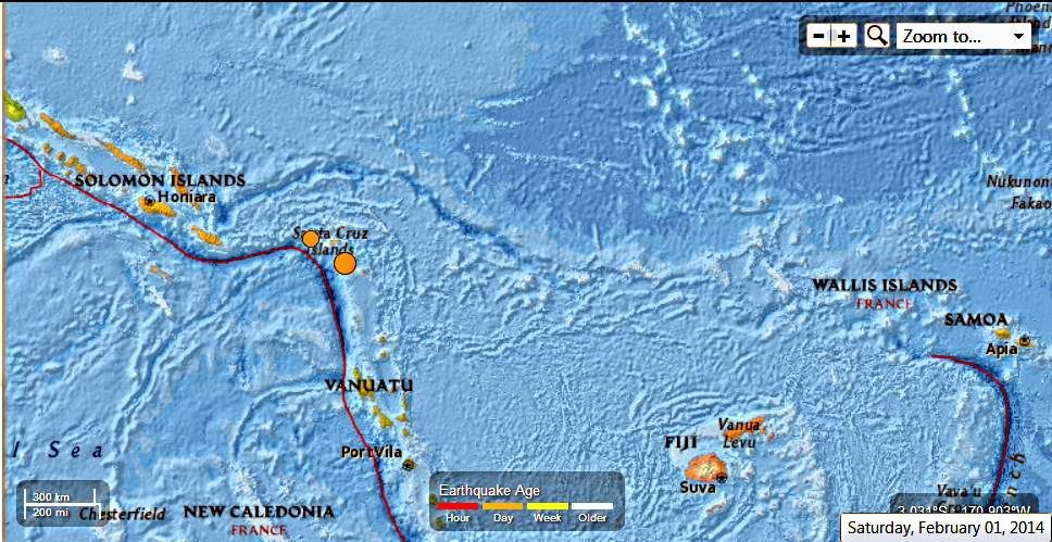

Soloman Islands  5.7 and 4.8 Mag EQ  February 1st 2014 photo SolomanIslands57and48MagEQFebruary1st2014_zps5b9eba20.jpg

2 earthquakes in map area

  1. M 5.7 - 92km SSE of Lata, Solomon Islands

     2014-02-01 13:59:59 UTC-06:00 32.0 km

  2. M 4.8 - 72km W of Lata, Solomon Islands

     2014-02-01 00:31:18 UTC-06:00 48.0 km

USGS


.....

M 5.7 - 92km SSE of Lata, Solomon Islands

 2014-02-01 19:59:59 UTC

Earthquake location 11.433°S, 166.278°E

Event Time

  1. 2014-02-01 19:59:59 UTC
  2. 2014-02-02 06:59:59 UTC+11:00 at epicenter
  3. 2014-02-01 13:59:59 UTC-06:00 system time

Location

11.433°S 166.278°E depth=32.0km (19.9mi)

Nearby Cities

  1. 92km (57mi) SSE of Lata, Solomon Islands
  2. 463km (288mi) NNW of Luganville, Vanuatu
  3. 727km (452mi) ESE of Honiara, Solomon Islands
  4. 731km (454mi) NNW of Port-Vila, Vanuatu
  5. 1054km (655mi) N of We, New Caledonia
.....

M 4.8 - 72km W of Lata, Solomon Islands

2014-02-01 06:31:18 UTC

Earthquake location 10.652°S, 165.176°E

Event Time

  1. 2014-02-01 06:31:18 UTC
  2. 2014-02-01 17:31:18 UTC+11:00 at epicenter
  3. 2014-02-01 00:31:18 UTC-06:00 system time

Location

10.652°S 165.176°E depth=48.0km (29.8mi)

Nearby Cities

  1. 72km (45mi) W of Lata, Solomon Islands
  2. 581km (361mi) NNW of Luganville, Vanuatu
  3. 588km (365mi) ESE of Honiara, Solomon Islands
  4. 853km (530mi) NNW of Port-Vila, Vanuatu
  5. 1157km (719mi) NNW of We, New Caledonia
.....

Tectonic Summary

Seismotectonics of the Eastern Margin of the Australia Plate

The eastern margin of the Australia plate is one of the most sesimically active areas of the world due to high rates of convergence between the Australia and Pacific plates. In the region of New Zealand, the 3000 km long Australia-Pacific plate boundary extends from south of Macquarie Island to the southern Kermadec Island chain. It includes an oceanic transform (the Macquarie Ridge), two oppositely verging subduction zones (Puysegur and Hikurangi), and a transpressive continental transform, the Alpine Fault through South Island, New Zealand.
Since 1900 there have been 15 M7.5+ earthquakes recorded near New Zealand. Nine of these, and the four largest, occurred along or near the Macquarie Ridge, including the 1989 M8.2 event on the ridge itself, and the 2004 M8.1 event 200 km to the west of the plate boundary, reflecting intraplate deformation. The largest recorded earthquake in New Zealand itself was the 1931 M7.8 Hawke's Bay earthquake, which killed 256 people. The last M7.5+ earthquake along the Alpine Fault was 170 years ago; studies of the faults' strain accumulation suggest that similar events are likely to occur again.
North of New Zealand, the Australia-Pacific boundary stretches east of Tonga and Fiji to 250 km south of Samoa. For 2,200 km the trench is approximately linear, and includes two segments where old (>120 Myr) Pacific oceanic lithosphere rapidly subducts westward (Kermadec and Tonga). At the northern end of the Tonga trench, the boundary curves sharply westward and changes along a 700 km-long segment from trench-normal subduction, to oblique subduction, to a left lateral transform-like structure.
Australia-Pacific convergence rates increase northward from 60 mm/yr at the southern Kermadec trench to 90 mm/yr at the northern Tonga trench; however, significant back arc extension (or equivalently, slab rollback) causes the consumption rate of subducting Pacific lithosphere to be much faster. The spreading rate in the Havre trough, west of the Kermadec trench, increases northward from 8 to 20 mm/yr. The southern tip of this spreading center is propagating into the North Island of New Zealand, rifting it apart. In the southern Lau Basin, west of the Tonga trench, the spreading rate increases northward from 60 to 90 mm/yr, and in the northern Lau Basin, multiple spreading centers result in an extension rate as high as 160 mm/yr. The overall subduction velocity of the Pacific plate is the vector sum of Australia-Pacific velocity and back arc spreading velocity: thus it increases northward along the Kermadec trench from 70 to 100 mm/yr, and along the Tonga trench from 150 to 240 mm/yr.
The Kermadec-Tonga subduction zone generates many large earthquakes on the interface between the descending Pacific and overriding Australia plates, within the two plates themselves and, less frequently, near the outer rise of the Pacific plate east of the trench. Since 1900, 40 M7.5+ earthquakes have been recorded, mostly north of 30°S. However, it is unclear whether any of the few historic M8+ events that have occurred close to the plate boundary were underthrusting events on the plate interface, or were intraplate earthquakes. On September 29, 2009, one of the largest normal fault (outer rise) earthquakes ever recorded (M8.1) occurred south of Samoa, 40 km east of the Tonga trench, generating a tsunami that killed at least 180 people.
Across the North Fiji Basin and to the west of the Vanuatu Islands, the Australia plate again subducts eastwards beneath the Pacific, at the North New Hebrides trench. At the southern end of this trench, east of the Loyalty Islands, the plate boundary curves east into an oceanic transform-like structure analogous to the one north of Tonga.
Australia-Pacific convergence rates increase northward from 80 to 90 mm/yr along the North New Hebrides trench, but the Australia plate consumption rate is increased by extension in the back arc and in the North Fiji Basin. Back arc spreading occurs at a rate of 50 mm/yr along most of the subduction zone, except near ~15°S, where the D'Entrecasteaux ridge intersects the trench and causes localized compression of 50 mm/yr in the back arc. Therefore, the Australia plate subduction velocity ranges from 120 mm/yr at the southern end of the North New Hebrides trench, to 40 mm/yr at the D'Entrecasteaux ridge-trench intersection, to 170 mm/yr at the northern end of the trench.
Large earthquakes are common along the North New Hebrides trench and have mechanisms associated with subduction tectonics, though occasional strike slip earthquakes occur near the subduction of the D'Entrecasteaux ridge. Within the subduction zone 34 M7.5+ earthquakes have been recorded since 1900. On October 7, 2009, a large interplate thrust fault earthquake (M7.6) in the northern North New Hebrides subduction zone was followed 15 minutes later by an even larger interplate event (M7.8) 60 km to the north. It is likely that the first event triggered the second of the so-called earthquake "doublet".
More information on regional seismicity and tectonics
.....
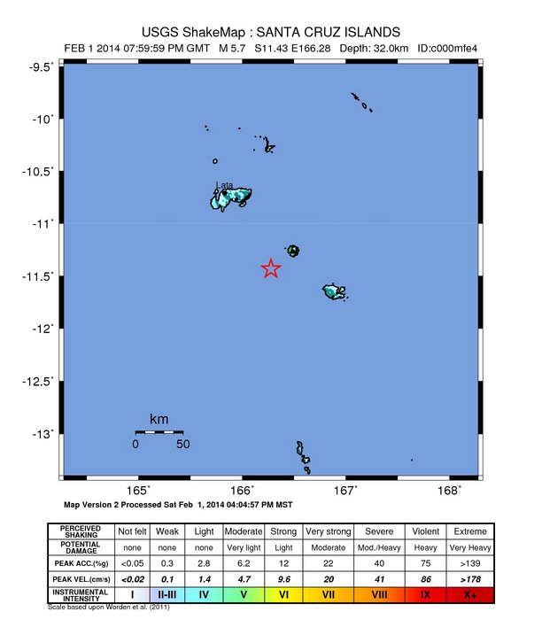
Instrumental Intensity

ShakeMap Intensity Image
.....
Enhanced by Zemanta

Monday, July 8, 2013

Papua New Guinea - 7.2 and 6.6 Magnitude Earthquakes July 7th , 2013

Earth Watch Report  -  Earthquakes

 photo PapuaNewGuinea-72and66MagEQJuly7th2013_zpsc5382286.jpg
....

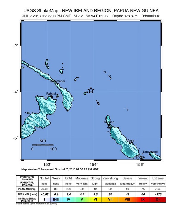
M7.2 - 110km ENE of Taron, Papua New Guinea

 2013-07-07 18:35:30 UTC

Earthquake location 3.939°S, 153.882°E

Event Time

  1. 2013-07-07 18:35:30 UTC
  2. 2013-07-08 04:35:30 UTC+10:00 at epicenter
  3. 2013-07-07 13:35:30 UTC-05:00 system time

Location

3.939°S 153.882°E depth=378.8km (235.4mi)

Nearby Cities

  1. 110km (68mi) ENE of Taron, Papua New Guinea
  2. 185km (115mi) ENE of Kokopo, Papua New Guinea
  3. 311km (193mi) NW of Arawa, Papua New Guinea
  4. 374km (232mi) ESE of Kavieng, Papua New Guinea
  5. 904km (562mi) NW of Honiara, Solomon Islands
....

Instrumental Intensity

ShakeMap Intensity Image
....
 photo PapuaNewGuinea-72MagEQJuly7th2013_zpsd5fbb8b8.jpg
....

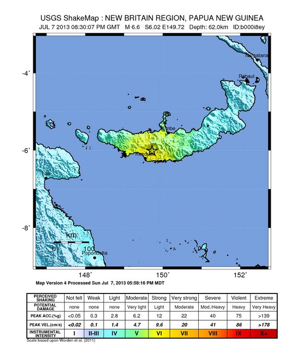
M6.6 - 29km NE of Kandrian, Papua New Guinea

 2013-07-07 20:30:07 UTC

Earthquake location 6.016°S, 149.721°E

Event Time

  1. 2013-07-07 20:30:07 UTC
  2. 2013-07-08 06:30:07 UTC+10:00 at epicenter
  3. 2013-07-07 15:30:07 UTC-05:00 system time

Location

6.016°S 149.721°E depth=62.0km (38.5mi)

Nearby Cities

  1. 29km (18mi) NE of Kandrian, Papua New Guinea
  2. 69km (43mi) SW of Kimbe, Papua New Guinea
  3. 312km (194mi) ENE of Lae, Papua New Guinea
  4. 336km (209mi) WSW of Kokopo, Papua New Guinea
  5. 471km (293mi) NE of Port Moresby, Papua New Guinea
....

Instrumental Intensity

ShakeMap Intensity Image
....
....

Tectonic Summary

Seismotectonics of the New Guinea Region and Vicinity

The Australia-Pacific plate boundary is over 4000 km long on the northern margin, from the Sunda (Java) trench in the west to the Solomon Islands in the east. The eastern section is over 2300 km long, extending west from northeast of the Australian continent and the Coral Sea until it intersects the east coast of Papua New Guinea. The boundary is dominated by the general northward subduction of the Australia plate.
Along the South Solomon trench, the Australia plate converges with the Pacific plate at a rate of approximately 95 mm/yr towards the east-northeast. Seismicity along the trench is dominantly related to subduction tectonics and large earthquakes are common: there have been 13 M7.5+ earthquakes recorded since 1900. On April 1, 2007, a M8.1 interplate megathrust earthquake occurred at the western end of the trench, generating a tsunami and killing at least 40 people. This was the third M8.1 megathrust event associated with this subduction zone in the past century; the other two occurred in 1939 and 1977.
Further east at the New Britain trench, the relative motions of several microplates surrounding the Australia-Pacific boundary, including north-south oriented seafloor spreading in the Woodlark Basin south of the Solomon Islands, maintain the general northward subduction of Australia-affiliated lithosphere beneath Pacific-affiliated lithosphere. Most of the large and great earthquakes east of New Guinea are related to this subduction; such earthquakes are particularly concentrated at the cusp of the trench south of New Ireland. 33 M7.5+ earthquakes have been recorded since 1900, including three shallow thrust fault M8.1 events in 1906, 1919, and 2007.
The western end of the Australia-Pacific plate boundary is perhaps the most complex portion of this boundary, extending 2000 km from Indonesia and the Banda Sea to eastern New Guinea. The boundary is dominantly convergent along an arc-continent collision segment spanning the width of New Guinea, but the regions near the edges of the impinging Australia continental margin also include relatively short segments of extensional, strike-slip and convergent deformation. The dominant convergence is accommodated by shortening and uplift across a 250-350 km-wide band of northern New Guinea, as well as by slow southward-verging subduction of the Pacific plate north of New Guinea at the New Guinea trench. Here, the Australia-Pacific plate relative velocity is approximately 110 mm/yr towards the northeast, leading to the 2-8 mm/yr uplift of the New Guinea Highlands.
Whereas the northern band of deformation is relatively diffuse east of the Indonesia-Papua New Guinea border, in western New Guinea there are at least two small (<100,000 km²) blocks of relatively undeformed lithosphere. The westernmost of these is the Birds Head Peninsula microplate in Indonesia's West Papua province, bounded on the south by the Seram trench. The Seram trench was originally interpreted as an extreme bend in the Sunda subduction zone, but is now thought to represent a southward-verging subduction zone between Birds Head and the Banda Sea.
There have been 22 M7.5+ earthquakes recorded in the New Guinea region since 1900. The dominant earthquake mechanisms are thrust and strike slip, associated with the arc-continent collision and the relative motions between numerous local microplates. The largest earthquake in the region was a M8.2 shallow thrust fault event in the northern Papua province of Indonesia that killed 166 people in 1996.
The western portion of the northern Australia plate boundary extends approximately 4800 km from New Guinea to Sumatra and primarily separates Australia from the Eurasia plate, including the Sunda block. This portion is dominantly convergent and includes subduction at the Sunda (Java) trench, and a young arc-continent collision.
In the east, this boundary extends from the Kai Islands to Sumba along the Timor trough, offset from the Sunda trench by 250 km south of Sumba. Contrary to earlier tectonic models in which this trough was interpreted as a subduction feature continuous with the Sunda subduction zone, it is now thought to represent a subsiding deformational feature related to the collision of the Australia plate continental margin and the volcanic arc of the Eurasia plate, initiating in the last 5-8 Myr. Before collision began, the Sunda subduction zone extended eastward to at least the Kai Islands, evidenced by the presence of a northward-dipping zone of seismicity beneath Timor Leste. A more detailed examination of the seismic zone along it's eastern segment reveals a gap in intermediate depth seismicity under Timor and seismic mechanisms that indicate an eastward propagating tear in the descending slab as the negatively buoyant oceanic lithosphere detaches from positively buoyant continental lithosphere. On the surface, GPS measurements indicate that the region around Timor is currently no longer connected to the Eurasia plate, but instead is moving at nearly the same velocity as the Australia plate, another consequence of collision.
Large earthquakes in eastern Indonesia occur frequently but interplate megathrust events related to subduction are rare; this is likely due to the disconnection of the descending oceanic slab from the continental margin. There have been 9 M7.5+ earthquakes recorded from the Kai Islands to Sumba since 1900. The largest was the great Banda Sea earthquake of 1938 (M8.5) an intermediate depth thrust faulting event that did not cause significant loss of life.


More information on regional seismicity and tectonics
....
Enhanced by Zemanta

Thursday, July 4, 2013

Papua New Guinea - 6.1 Magnitude Earthquake - 81km SSE of Panguna,

Earth Watch Report  -  Earthquakes


 photo PapuaNewGuinea-61MagEQJuly4th2013_zps8bbe0953.jpg
....

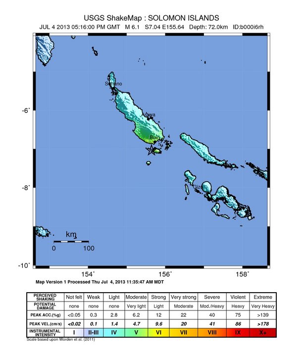
M6.1 - 81km SSE of Panguna, Papua New Guinea

 2013-07-04 17:16:00 UTC

Earthquake location 7.039°S, 155.644°E

Event Time

  1. 2013-07-04 17:16:00 UTC
  2. 2013-07-05 04:16:00 UTC+11:00 at epicenter
  3. 2013-07-04 12:16:00 UTC-05:00 system time

Location

7.039°S 155.644°E depth=72.0km (44.7mi)

Nearby Cities

  1. 81km (50mi) SSE of Panguna, Papua New Guinea
  2. 92km (57mi) S of Arawa, Papua New Guinea
  3. 478km (297mi) SE of Kokopo, Papua New Guinea
  4. 543km (337mi) WNW of Honiara, Solomon Islands
  5. 630km (391mi) ESE of Kimbe, Papua New Guinea
....

Tectonic Summary

Seismotectonics of the New Guinea Region and Vicinity

The Australia-Pacific plate boundary is over 4000 km long on the northern margin, from the Sunda (Java) trench in the west to the Solomon Islands in the east. The eastern section is over 2300 km long, extending west from northeast of the Australian continent and the Coral Sea until it intersects the east coast of Papua New Guinea. The boundary is dominated by the general northward subduction of the Australia plate.
Along the South Solomon trench, the Australia plate converges with the Pacific plate at a rate of approximately 95 mm/yr towards the east-northeast. Seismicity along the trench is dominantly related to subduction tectonics and large earthquakes are common: there have been 13 M7.5+ earthquakes recorded since 1900. On April 1, 2007, a M8.1 interplate megathrust earthquake occurred at the western end of the trench, generating a tsunami and killing at least 40 people. This was the third M8.1 megathrust event associated with this subduction zone in the past century; the other two occurred in 1939 and 1977.
Further east at the New Britain trench, the relative motions of several microplates surrounding the Australia-Pacific boundary, including north-south oriented seafloor spreading in the Woodlark Basin south of the Solomon Islands, maintain the general northward subduction of Australia-affiliated lithosphere beneath Pacific-affiliated lithosphere. Most of the large and great earthquakes east of New Guinea are related to this subduction; such earthquakes are particularly concentrated at the cusp of the trench south of New Ireland. 33 M7.5+ earthquakes have been recorded since 1900, including three shallow thrust fault M8.1 events in 1906, 1919, and 2007.
The western end of the Australia-Pacific plate boundary is perhaps the most complex portion of this boundary, extending 2000 km from Indonesia and the Banda Sea to eastern New Guinea. The boundary is dominantly convergent along an arc-continent collision segment spanning the width of New Guinea, but the regions near the edges of the impinging Australia continental margin also include relatively short segments of extensional, strike-slip and convergent deformation. The dominant convergence is accommodated by shortening and uplift across a 250-350 km-wide band of northern New Guinea, as well as by slow southward-verging subduction of the Pacific plate north of New Guinea at the New Guinea trench. Here, the Australia-Pacific plate relative velocity is approximately 110 mm/yr towards the northeast, leading to the 2-8 mm/yr uplift of the New Guinea Highlands.
Whereas the northern band of deformation is relatively diffuse east of the Indonesia-Papua New Guinea border, in western New Guinea there are at least two small (<100,000 km²) blocks of relatively undeformed lithosphere. The westernmost of these is the Birds Head Peninsula microplate in Indonesia's West Papua province, bounded on the south by the Seram trench. The Seram trench was originally interpreted as an extreme bend in the Sunda subduction zone, but is now thought to represent a southward-verging subduction zone between Birds Head and the Banda Sea.
There have been 22 M7.5+ earthquakes recorded in the New Guinea region since 1900. The dominant earthquake mechanisms are thrust and strike slip, associated with the arc-continent collision and the relative motions between numerous local microplates. The largest earthquake in the region was a M8.2 shallow thrust fault event in the northern Papua province of Indonesia that killed 166 people in 1996.
The western portion of the northern Australia plate boundary extends approximately 4800 km from New Guinea to Sumatra and primarily separates Australia from the Eurasia plate, including the Sunda block. This portion is dominantly convergent and includes subduction at the Sunda (Java) trench, and a young arc-continent collision.
In the east, this boundary extends from the Kai Islands to Sumba along the Timor trough, offset from the Sunda trench by 250 km south of Sumba. Contrary to earlier tectonic models in which this trough was interpreted as a subduction feature continuous with the Sunda subduction zone, it is now thought to represent a subsiding deformational feature related to the collision of the Australia plate continental margin and the volcanic arc of the Eurasia plate, initiating in the last 5-8 Myr. Before collision began, the Sunda subduction zone extended eastward to at least the Kai Islands, evidenced by the presence of a northward-dipping zone of seismicity beneath Timor Leste. A more detailed examination of the seismic zone along it's eastern segment reveals a gap in intermediate depth seismicity under Timor and seismic mechanisms that indicate an eastward propagating tear in the descending slab as the negatively buoyant oceanic lithosphere detaches from positively buoyant continental lithosphere. On the surface, GPS measurements indicate that the region around Timor is currently no longer connected to the Eurasia plate, but instead is moving at nearly the same velocity as the Australia plate, another consequence of collision.
Large earthquakes in eastern Indonesia occur frequently but interplate megathrust events related to subduction are rare; this is likely due to the disconnection of the descending oceanic slab from the continental margin. There have been 9 M7.5+ earthquakes recorded from the Kai Islands to Sumba since 1900. The largest was the great Banda Sea earthquake of 1938 (M8.5) an intermediate depth thrust faulting event that did not cause significant loss of life.
More information on regional seismicity and tectonics
....

Instrumental Intensity

ShakeMap Intensity Image
....
Enhanced by Zemanta