Showing posts with label Montana. Show all posts

Tuesday, April 1, 2014

Yellowstone: M 4.7 Earthquake , 37km ENE of West Yellowstone, Montana - the biggest recorded there since February 1980. A total of 13 EQ ranging in Magnitude from 2.5 to 4.7 in the last 5 days 3/31/2014


Yellowstone: M 4.7 Earthquake , 37km ENE of West Yellowstone, Montana - 13 EQ ranging in Magnitude from 2.5 to 4.7 in the last 5 days 3/31/2014


 photo MontanaYellowstone-48MagEQ3302014_zps98c00d38.png

13 earthquakes in map area

  1. M 3.1 - 35km NNE of Old Faithful Geyser, Wyoming

     2014-03-31 23:32:45 UTC-05:00 3.6 km

  2. M 2.7 - 33km ENE of West Yellowstone, Montana

     2014-03-30 12:37:31 UTC-05:00 5.1 km

  3. M 3.3 - 32km ENE of West Yellowstone, Montana

     2014-03-30 10:12:24 UTC-05:00 6.0 km

  4. M 3.1 - 32km ENE of West Yellowstone, Montana

     2014-03-30 10:07:49 UTC-05:00 6.6 km

  5. M 2.9 - 33km ENE of West Yellowstone, Montana

     2014-03-30 08:56:41 UTC-05:00 3.9 km

  6. M 3.6 - 34km ENE of West Yellowstone, Montana

     2014-03-30 08:30:52 UTC-05:00 4.4 km

  7. M 4.7 - 37km ENE of West Yellowstone, Montana

     2014-03-30 07:34:39 UTC-05:00 5.6 km

  8. M 2.5 - 35km ENE of West Yellowstone, Montana

     2014-03-30 07:18:58 UTC-05:00 3.6 km

  9. M 3.4 - 35km ENE of West Yellowstone, Montana

     2014-03-30 05:36:25 UTC-05:00 3.9 km

  10. M 2.8 - 36km ENE of West Yellowstone, Montana

     2014-03-30 01:23:48 UTC-05:00 1.5 km

  11. M 2.5 - 30km ENE of West Yellowstone, Montana

     2014-03-26 20:24:06 UTC-05:00 6.2 km

  12. M 3.5 - 30km ENE of West Yellowstone, Montana

     2014-03-26 18:59:00 UTC-05:00 4.5 km

  13. M 3.0 - 30km ENE of West Yellowstone, Montana

     2014-03-26 14:14:36 UTC-05:00 6.4 km

.....

 Huffington Post Green


Yellowstone National Park Hit By Magnitude 4.8 Earthquake

Posted: Updated:
YELLOWSTONE


By Laura Zuckerman

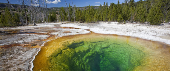
March 30 (Reuters) - Yellowstone National Park, which sits atop one of the world's largest super-volcanoes, was struck on Sunday by a magnitude 4.8 earthquake, the biggest recorded there since February 1980, but no damage or injuries were immediately reported.

The tremor, a relatively light event by seismic standards, struck the northwest corner of the park and capped a flurry of smaller quakes at Yellowstone since Thursday, geologists at the University of Utah Seismograph Stations said in a statement.

The latest earthquake struck at 6:34 a.m. near the Norris Geyser Basin and was felt about 23 miles (37 km) away in two small Montana towns adjacent to year-around entrances to the park - Gardiner and West Yellowstone.

The national park spans 3,472 square miles (8,992 square km) of Wyoming, Montana and Idaho, and draws about 3 million visitors each year to its iconic geysers and wildlife attractions, including bison.

A U.S. Geological Survey team planned to tour the Norris Geyser Basin on Sunday to determine if the quake altered any of Yellowstone's geothermal features, such as geysers, mud pots and hot springs.

Read More Here
.....

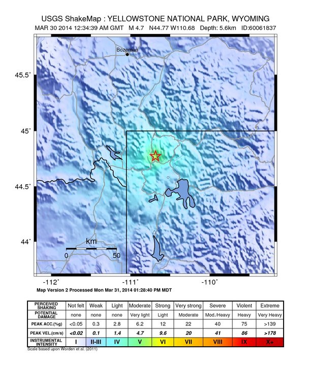
Instrumental Intensity

ShakeMap Intensity Image

.....

Recent Earthquakes in the Intermountain West

Yellowstone National Park Special Map

Special Map

get updated list here


Update time = Sun Mar 30 18:00:04 MDT 2014
Here are the earthquakes appearing on this map, most recent at top ...

 MAG    DATE    LOCAL-TIME  LAT     LON    DEPTH    LOCATION
        y/m/d     h:m:s     deg     deg     km
 3.3  2014/03/30 09:12:24 44.777N 110.723W  6.0   29 km (18 mi) S   of  Gardiner, MT
 3.1  2014/03/30 09:07:49 44.770N 110.720W  6.6   30 km (18 mi) S   of  Gardiner, MT
 2.5  2014/03/30 07:56:40 44.770N 110.714W  7.7   30 km (18 mi) S   of  Gardiner, MT
 3.1  2014/03/30 07:30:52 44.772N 110.698W  4.5   29 km (18 mi) S   of  Gardiner, MT
 4.8  2014/03/30 06:34:39 44.778N 110.683W  6.8   29 km (18 mi) S   of  Gardiner, MT
 3.0  2014/03/30 04:36:25 44.786N 110.690W  1.6   28 km (17 mi) S   of  Gardiner, MT
 2.8  2014/03/30 00:23:48 44.785N 110.681W  1.5   28 km (17 mi) S   of  Gardiner, MT
 0.5  2014/03/28 09:41:43 44.825N 110.781W  3.1   24 km (15 mi) SSW of  Gardiner, MT
 2.0  2014/03/28 05:37:16 44.839N 110.513W  7.1   27 km (17 mi) SE  of  Gardiner, MT
 1.9  2014/03/26 18:58:40 44.808N 110.773W  4.3   26 km (16 mi) S   of  Gardiner, MT
 2.2  2014/03/26 18:20:59 44.800N 110.772W  4.1   27 km (17 mi) S   of  Gardiner, MT
 1.5  2014/03/26 18:11:57 44.821N 110.774W  2.0   24 km (15 mi) S   of  Gardiner, MT
 2.0  2014/03/26 18:00:10 44.799N 110.774W  3.9   27 km (17 mi) S   of  Gardiner, MT
 3.5  2014/03/26 17:59:00 44.801N 110.778W  4.5   27 km (17 mi) S   of  Gardiner, MT
 3.0  2014/03/26 13:14:36 44.804N 110.772W  6.4   26 km (16 mi) S   of  Gardiner, MT
 1.4  2014/03/24 12:06:51 44.246N 110.444W  3.6   70 km (43 mi) SE  of  West Yellowstone, MT
 1.7  2014/03/24 05:21:37 44.778N 110.774W  7.5   29 km (18 mi) S   of  Gardiner, MT
 1.1  2014/03/23 22:55:22 44.574N 110.410W  2.7   56 km (35 mi) E   of  West Yellowstone, MT
.....

UPI

Ancient helium rising to the surface in Yellowstone National Park

Feb. 20, 2014 at 4:46 PM


Steam plumes rise above thermal features at Yellowstone National Park. The U.S. Geological Survey determined the famed national park was releasing hundreds -- if not thousands -- of times more helium than anticipated. Credit: Ken McGee/U.S. Geological Survey


MENLO PARK, Calif., Feb. 20 (UPI) -- Helium, trapped underground for 2 billion years, is bubbling to the surface from steam vents and hot springs of Yellowstone National Park, U.S. researchers say.Researchers with the U.S. Geological Survey say the park, located mostly in Wyoming, was releasing hundreds, even possible thousands, of times more of the ancient helium than previously thought, the Los Angeles Times reported Thursday.
About 60 tons are being release each year, enough helium to fill one Goodyear blimp every week, researchers said in a report published in the journal Nature.
Volcanic activity beginning about 2 million years ago initiated the release, they said.
That counts as a "sudden" release compared with how long the helium has been trapped within the Earth's surface, study coauthor Bill Evans, a research chemist at the USGS office in Menlo Park, Calif., said.


Read More Here
.....


Enhanced by Zemanta

Monday, October 28, 2013

South Dakota cattle ranchers struggle to recover after devastating snowstorm


State waits on Congress farm bill talks after October blizzard which killed up to a third of some ranchers' stocks
  • theguardian.com,
Rancher Joe Carley
Rancher Joe Carley works at the Philip Livestock Auction in Philip, South Dakota. Photograph: Chet Brokaw/AP
Joe Carley has nearly finished burying the cattle he lost in a freak early fall blizzard that killed tens of thousands of cattle in western South Dakota. Now, he is figuring out how to dig himself out of the financial hole left after about a quarter of his cows and maybe a third of his calves died in the storm.
"There's some sleepless nights. There's a lot of worry. My brain's always rolling. We're pulling ourselves out of it, you know. We're trying to figure things out and step forward," said Carley, 40, of Philip, during a break from herding cattle at the local livestock sale barn, where he works to help make ends meet.
Other ranchers in the area also don't plan to give up, despite what state officials have estimated as a loss of 15,000 to 30,000 cattle in the 4-5 October storm that dumped up to 4ft of snow in some parts. The financial loss is staggering, with each calf worth more than $1,000 and each pregnant cow worth $1,500 to $2,000. To make matters worse, most ranchers were only a few weeks away from selling the calves born last spring – their paycheck for the year.
Ranchers like Carley may get low-interest loans or loan guarantees from a US Agriculture Department program and could get some help from a relief fund set up by livestock organizations that have so far collected donations of $400,000 from people in nearly every state and some other countries. A Montana organization is asking ranchers in that state to donate heifers that can be given to help South Dakota ranchers rebuild their herds.
Ranchers also could get a big boost if a federal livestock disaster program that expired in 2011 is revived in a new farm bill. The House and Senate versions of the new farm bill include provisions to do so and to provide retroactive payments, but the two chambers have been unable to agree on a farm bill after passing different versions several months ago. Spurred partly by the disaster, the House and Senate now plan to restart negotiations.
"Anything will help, I guess," said Carley, who lost 51 cows and 70 calves. "We're not asking for handouts, either, but there are a lot of people in need around here."

Read More Here
Enhanced by Zemanta

Thursday, September 19, 2013

Montana - More than 100 dead deer found in West Missoula Valley area

KRTV.com

Posted: Sep 19, 2013 1:09 PM by MTN News - Misoula
Updated: Sep 19, 2013 1:09 PM


MISSOULA - Montana wildlife officials report that more than 100 dead white-tailed deer have been reported in the west Missoula Valley.
Montana Fish, Wildlife & Parks officials say they are waiting for lab results to come back so they can try to determine what's caused the deaths.
The public is also being asked to report observations of dead deer to help determine how big of an area is being affected area.
Spokeswoman Vivaca Crowser says FWP first responded to reports from fishing guides and landowners who reported numerous dead deer in and along the Clark Fork River and fields near and downstream from Harper's Bridge.
She adds in a news release that dead deer have also been found in the Mill Creek area northeast of Frenchtown.
FWP biologists and wardens had accounted for 103 dead deer by Tuesday, with deer still dying and more dead deer undetected.
Read More Here
**************************************************************************

RESIDENTS SHOCKED AS 100 DEER FOUND DEAD IN MISSOULA, MONTANA TUESDAY (SEPT 18, 2013)

ADRENALINEJUNKY -JASON HENDRICKS ADRENALINEJUNKY -JASON HENDRICKS


**************************************************************************
Billings Gazette

Biologists 'floored by mortality' of whitetail deer along Clark Fork River


FRENCHTOWN – Something is killing whitetail deer by the dozens along the Clark Fork River.“This feels strange,” Montana Fish, Wildlife and Parks biologist Jay Kolbe said as he walked through high grass on an island across from the former Smurfit-Stone Container Corp. pulp mill. “We ought to be bumping into whitetail all along here.”Instead, the only deer visible were bloated carcasses sticking out of the water, or lying half-eaten on the shore. In the trees, three immature bald eagles, a golden eagle and several hawks shuffled about, waiting for another chance to feed on the carrion.
In a 30-minute walk, Kolbe came across 15 dead deer in various states of decay. He waded into a pool to pull one relatively fresh one to shore for closer examination. The fur on its lower jaw was still slightly bloodstained, and its mouth showed the signs of internal hemorrhaging.
“They come down to water because they’re just burning up inside,” Kolbe said. “I’m hoping to find a still-live one to dispatch so we can get a definite confirmation. These are too far gone to get good blood or tissue.”
More than 100 whitetails have died in this area since the second week of September.
A virus that causes epizootic hemorrhagic disease is the most likely culprit. It’s spread by biting gnats or midges, and primarily affects only whitetail deer. A similar disease commonly known as “blue tongue” hits antelope and has damaged populations throughout eastern Montana.
Mule deer, elk, antelope and bighorn sheep can also get EHD, but incidents are rare. Domestic cattle are generally not affected by either disease, although domestic sheep can be susceptible to blue tongue.
“I worked the Southside Road yesterday, and I was just floored by the level of mortality,” FWP biologist Vickie Edwards said. “They’re on gravel bars or floating in the river. In some places, you can really smell them. The ravens, golden eagles and bald eagles are having a heyday.”


**************************************************************************

Science News

Wildlife Managers Track Mysterious Deer Die-off in Montana

Wildlife managers in Montana are trying to pinpoint whether a disease, environmental toxin or chemical agent has caused a die-off of more than 100 whitetail deer in wetlands along a river corridor in the western part of the state.
Reuters
0
By Laura Zuckerman
(Reuters) - Wildlife managers in Montana are trying to pinpoint whether a disease, environmental toxin or chemical agent has caused a die-off of more than 100 whitetail deer in wetlands along a river corridor in the western part of the state.
The Montana Fish Wildlife and Parks office in Missoula began to receive reports from landowners and boaters 10 days ago of dead deer along the Clark Fork River, and state wildlife biologists had tallied 103 deer carcasses by Tuesday.
"The deer appear to drop dead in their tracks," said agency educator Vivaca Crowser, adding that the deer showed no outward signs of injury or sickness.
Wildlife experts said a viral disease transmitted by tiny biting flies that hatch near bodies of water may be the culprit, but they were awaiting results from testing by a state lab of organ and blood samples.


Read More Here


**************************************************************************

Enhanced by Zemanta

Saturday, August 3, 2013

Tornado - State of Montana, Twin Bridges

Earth Watch Report  -  Tornado

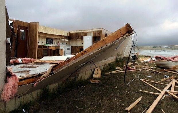
A mobile home in Acton
A mobile home in Acton was peeled open after a severe storm passed through the area Thursday evening.
...
03.08.2013TornadoUSAState of Montana, Twin BridgesDamage level Details
...

Tornado in USA on Friday, 02 August, 2013 at 03:41 (03:41 AM) UTC.

Description
We've learned a possible tornado touched down in Twin Bridges during a severe thunderstorm on Thursday afternoon. Madison County Sheriff's Office Public Information Officer Steve DiGiovanna tells NBC Montana the National Weather Service is heading down to the town Friday morning to investigate. He says someone took a video of the storm, and he witnessed what appeared to be a tornado funnel touching the ground. The possible tornado may be responsible for some of the damage that tore through the town, DiGiovanna said. A veterinary clinic outside of town had the roof ripped off, he said. The thunderstorm left the entire town and surrounding area without power. DiGiovanna said at least six high-voltage power poles are completely knocked down, and power will not be restored for at least 24 hours- if not two to three days. Other damage to the town includes roofs ripped off of several buildings, such as the aforementioned vet clinic and the public works building. Viewers who sent NBC Montana photos of the damage report buildings in town seem to have had roofs missing as well. At least 100 trees are down, DiGiovanna said, and several buildings suffered structural damage from them. Luckily, no one was hurt, DiGiovanna said. Right now, the fire department, sheriff's office, Disaster Emergency Services and dozens of volunteers are working to clear up as much of the fallen trees as they can. He said at least 100 people chipped in to help, and it was great to see the community come together during the disaster. NBC Montana is working to get the latest details on this developing story, and will post updates here and on our Facebook page.
...

RAVALLI REPUBLIC

Fast-moving storm tears up Acton trailer park

August 02, 2013 2:00 pm  • 
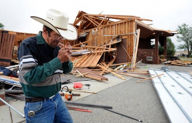
ACTON — Acton Bar owner Duane Cowdin was "nice and cozy" inside his bar when a storm raced through the area Thursday night.
The bar momentarily lost power, and he could tell there were high winds outside, but he didn't figure it was much of a storm. Then a neighbor stopped in and asked, "You been to your house? The garage is gone."
"It raised hell, didn't it?" Cowdin said Friday morning, standing near what was left of his garage. "It scattered s--- from hell to breakfast."
Cowdin's house is a little southeast of the Acton Bar. At a trailer park little farther east on Highway 3, at least four trailer houses were destroyed Thursday night and another three or four were damaged.
Joe Lester, a meteorologist with the National Weather Service in Billings, said the damage in Acton was caused by straight-line winds that probably reached 90 miles an hour shortly after 8:30 p.m. Thursday.
He said debris was strewn for a mile in an area about 200 yards wide, and all the debris followed the same northwest-to-southeast orientation, which would suggest straight-line winds, not a funnel cloud.


Read More and See Additional Photos Here


Enhanced by Zemanta