Showing posts with label Pacific Ring of Fire. Show all posts

Saturday, February 15, 2014

Mount Kelud eruption: Why it makes Indonesia the hottest spot on the Ring of Fire?


The overnight eruption of Java island's Mount Kelud has triggered the evacuation of 100,000 people, but just what causes such volatile activity?

Indonesia has experienced yet more volcanic activity as Mount Kelud erupted on Thursday, causing 100,000 to flee their homes and covering Java - the country’s most heavily populated island - in ash. But why is the region such a hotbed of volcanic activity?
Indonesia has approximately 130 active volcanoes. Due to its population density and the fertile soils that volcanic slopes provide, hundreds of thousands of Indonesians live close to active volcanos. They have learnt to live with the rumblings and frequently ignore orders to leave.
The huge archipelago sits between the most active seismic region in the world, the Pacific Ring of Fire, an area where a large number of earthquakes and volcanic eruptions occur, and the Alpide Belt.
The United States Geological Survey has described the region as among the most seismically active zones in the world. The Ring of Fire, or the circum-Pacific belt, is the world’s greatest earthquake belt, according to Live Science, because of fault lines running from Chile to Japan and Southeast Asia.
These fault lines are breaks in the plates of the Earth’s crust and are where earthquakes are likely to occur.
The Pacific Ring of Fire is also home to 453 volcanoes and more than half of the world’s active and dormant volcanoes are found here.
Indonesia is located between the Pacific, Eurasian, and Australian tectonic plates. When one of the plates moves, it causes earthquakes, volcanic eruptions and even tsunamis in Indonesia and the surrounding areas.
Read More Here

.....
VOA

Indonesian Volcano Causes Chaos, 3 Deaths


Indonesian President Susilo Bambang Yudhoyono has declared a state of emergency on the main island of Java because of a major volcanic eruption.

Mount Kelud erupted late Thursday, sending a cloud of ash 30 kilometers into the sky.

The eruption killed three people and forced 100,000 to evacuate their homes.

The volcano has coated towns as far as 500 kilometers away with ash and rocks. Schools and businesses were closed and flights grounded at seven airports.

Hadi Rudyatmo, mayor of Surakarta in Central Java, tells VOA that his city was paralyzed Friday with all stores and schools shut down.

Scientists think the worst of the eruptions are over.


Indonesia has around 130 active volcanoes.

Read More Here

.....

Mass evacuation in Indonesia as Java volcano erupts

Three people have been killed after their home collapsed from the weight of volcanic ash, as Alice Budisatrijo reports
Tens of thousands of Indonesians have fled their homes after a volcano erupted in east Java.
Mount Kelud spewed ash and debris over a large area, including the city of Surabaya, about 130km (80 miles) away.
Officials said three people died after their houses collapsed under the weight of ash.
Airports in Surabaya, Yogyakarta and Solo shut down because of low visibility. There are also fears that debris could damage aircraft engines.
Yogyakarta airport manager Andi Wirson said the runway was covered in a 5cm-thick layer of ash.
A man wears a mask as he rides a rickshaw on a road covered with ash from Mount Kelud, in Yogyakarta, 14 February 2014 Residents wore masks to protect themselves from the dust and ash in the air
A woman gestures during the evacuation in Malang, East Java province, Indonesia, on 14 February 2014 Thousands of people were ordered to evacuate their homes and seek temporary shelter

Read More Here
.....
Enhanced by Zemanta

Wednesday, November 13, 2013

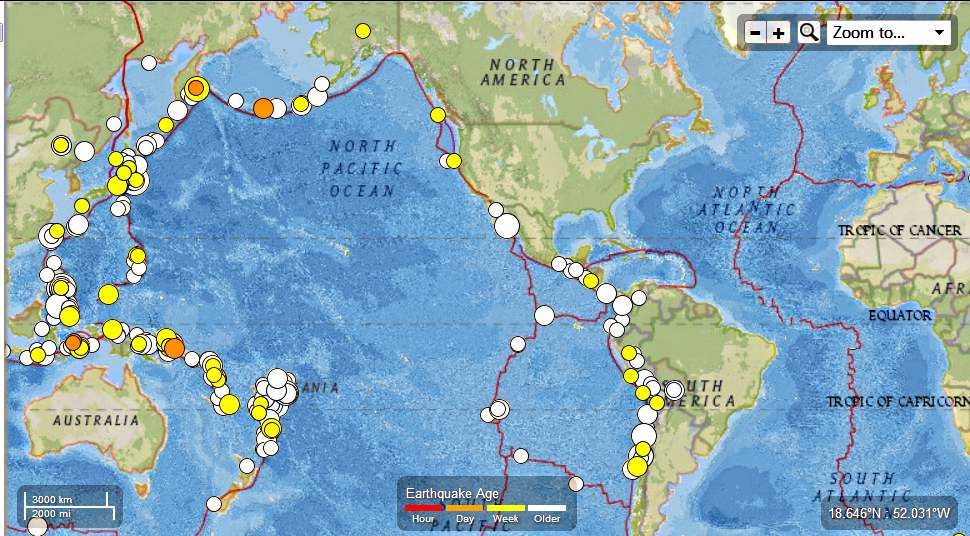
Pacific Ring of Fire - 327 Earthquakes ranging in Magnitude from 4.5 to 7.1 between October 14 to November 12th 2013

Earth Watch Report  -  Earthquakes


Pacific Ring of Fire  From October 13 to November 12th  2013 photo PacificRingofFireFromOctober13toNovember12th2013_zpsf02525ea.jpg
Pacific Ring of Fire  From October 14th to November 12th  2013
Magnitude 4.5 -4.9
Magnitude 5.0 to 5.9
Magnitude 6.0 and higher
.....
327 earthquakes in map area
  1. 4.5 202km SSW of Amahusu, Indonesia 2013-11-13 10:02:16 UTC-06:00 397.3 km
  2. 4.5 158km S of Amahusu, Indonesia 2013-11-13 08:37:15 UTC-06:00 359.4 km
  3. 5.8 33km NNE of Amatignak Island, Alaska 2013-11-12 21:57:42 UTC-06:00 29.6 km
  4. 4.8 149km S of Ust'-Kamchatsk Staryy, Russia 2013-11-12 20:25:44 UTC-06:00 39.8 km
  5. 5.1 61km SW of Chirovanga, Solomon Islands 2013-11-12 14:00:19 UTC-06:00 64.7 km
  6. 4.7 92km NNW of Talkeetna, Alaska 2013-11-12 12:16:48 UTC-06:00 131.5 km
  7. 4.6 74km SSE of Pondaguitan, Philippines 2013-11-12 11:59:18 UTC-06:00 105.0 km
  8. 4.9 59km ENE of Kainantu, Papua New Guinea 2013-11-12 09:58:36 UTC-06:00 114.8 km
  9. 4.7 104km W of Kamiiso, Japan 2013-11-12 05:36:03 UTC-06:00 186.3 km
  10. 4.9 Northern Mid-Atlantic Ridge 2013-11-12 04:41:05 UTC-06:00 10.0 km
  11. 4.9 Northern Mid-Atlantic Ridge 2013-11-12 03:59:18 UTC-06:00 10.0 km
  12. 4.7 210km NW of Saumlaki, Indonesia 2013-11-12 03:55:20 UTC-06:00 160.0 km
  13. 4.6 South of the Fiji Islands 2013-11-12 03:43:12 UTC-06:00 511.4 km
  14. 6.6 172km S of Ust'-Kamchatsk Staryy, Russia 2013-11-12 01:03:51 UTC-06:00 47.2 km
  15. 4.8 0km NW of San Isidro, Philippines 2013-11-11 23:21:28 UTC-06:00 68.7 km
  16. 4.5 60km E of Uchiza, Peru 2013-11-11 21:51:11 UTC-06:00 48.4 km
  17. 4.5 208km WSW of Arica, Chile 2013-11-11 16:28:37 UTC-06:00 14.5 km
  18. 4.6 78km WSW of Panguna, Papua New Guinea 2013-11-11 15:05:01 UTC-06:00 78.3 km
  19. 4.9 57km SE of Ofunato, Japan 2013-11-11 14:54:28 UTC-06:00 56.5 km
  20. 4.7 92km SW of Panguna, Papua New Guinea 2013-11-11 14:25:57 UTC-06:00 88.3 km
  21. 5.1 55km ENE of Taron, Papua New Guinea 2013-11-11 13:22:33 UTC-06:00 103.1 km
  22. 5.0 145km NW of Kota Ternate, Indonesia 2013-11-11 08:00:08 UTC-06:00 28.1 km
  23. 4.8 36km N of Pagan, Northern Mariana Islands 2013-11-11 02:21:36 UTC-06:00 212.2 km
  24. 4.7 65km SW of Palpa, Peru 2013-11-10 23:15:47 UTC-06:00 17.0 km
  25. 4.9 45km NNE of Yonakuni, Japan 2013-11-10 22:55:10 UTC-06:00 127.6 km
  26. 4.8 52km SW of Masachapa, Nicaragua 2013-11-10 15:43:25 UTC-06:00 49.7 km
  27. 4.8 22km SSW of Makurazaki, Japan 2013-11-10 07:29:21 UTC-06:00 169.0 km
  28. 4.5 65km NE of Port-Olry, Vanuatu 2013-11-10 06:24:08 UTC-06:00 176.3 km
  29. 4.8 Off the east coast of Honshu, Japan 2013-11-09 23:24:35 UTC-06:00 10.1 km
  30. 4.5 Kuril Islands 2013-11-09 22:11:54 UTC-06:00 90.1 km
  31. 4.8 72km SSE of Nikolski, Alaska 2013-11-09 21:35:42 UTC-06:00 20.1 km
  32. 4.8 31km WNW of San Antonio, Chile 2013-11-09 20:01:59 UTC-06:00 32.7 km
  33. 5.6 2km W of Moriya, Japan 2013-11-09 16:37:50 UTC-06:00 65.5 km
  34. 4.6 138km ENE of Raoul Island, New Zealand 2013-11-09 09:02:56 UTC-06:00 9.9 km
  35. 5.4 136km NE of Raoul Island, New Zealand 2013-11-09 08:53:28 UTC-06:00 10.0 km
  36. 4.8 79km NE of Calama, Chile 2013-11-09 07:26:10 UTC-06:00 112.4 km
  37. 5.1 247km WNW of Saumlaki, Indonesia 2013-11-09 04:58:18 UTC-06:00 131.1 km
  38. 4.6 138km NW of Tobelo, Indonesia 2013-11-09 01:48:41 UTC-06:00 23.6 km
  39. 4.5 138km E of Miyako, Japan 2013-11-08 23:03:22 UTC-06:00 30.9 km
  40. 4.9 204km SE of Lata, Solomon Islands 2013-11-08 21:45:21 UTC-06:00 71.9 km
  41. 5.2 42km S of Ngulu, Micronesia 2013-11-08 18:20:45 UTC-06:00 27.4 km
  42. 4.7 221km WNW of Saumlaki, Indonesia 2013-11-08 12:32:10 UTC-06:00 127.2 km
  43. 4.8 165km WSW of Port Hardy, Canada 2013-11-08 05:45:01 UTC-06:00 9.7 km
  44. 4.7 38km S of Qian'an, China 2013-11-08 05:37:20 UTC-06:00 15.3 km
  45. 4.7 102km WSW of Crescent City, California 2013-11-08 04:46:56 UTC-06:00 12.0 km
  46. 4.7 160km SSE of Taron, Papua New Guinea 2013-11-07 21:25:11 UTC-06:00 26.0 km
  47. 4.6 201km SSW of Ndoi Island, Fiji 2013-11-07 20:11:27 UTC-06:00 583.7 km
  48. 4.6 26km S of Plampang, Indonesia 2013-11-07 18:16:48 UTC-06:00 64.8 km
  49. 5.3 80km WSW of Panguna, Papua New Guinea 2013-11-07 14:13:54 UTC-06:00 61.6 km
  50. 4.5 45km WSW of Agrihan, Northern Mariana Islands 2013-11-07 13:33:35 UTC-06:00 467.0 km
  51. 4.6 107km E of Lakatoro, Vanuatu 2013-11-07 11:21:06 UTC-06:00 278.3 km
  52. 5.1 16km NNW of Lebu, Chile 2013-11-07 11:01:08 UTC-06:00 27.2 km
  53. 5.7 44km W of Ile Hunter, New Caledonia 2013-11-07 10:46:34 UTC-06:00 98.0 km
  54. 5.3 236km WNW of Abepura, Indonesia 2013-11-07 04:47:36 UTC-06:00 33.2 km
  55. 4.5 16km S of Piedecuesta, Colombia 2013-11-06 06:42:26 UTC-06:00 156.8 km
  56. 4.5 54km NNE of Isangel, Vanuatu 2013-11-06 00:59:54 UTC-06:00 260.9 km
  57. 5.4 93km E of Nago, Japan 2013-11-05 19:13:28 UTC-06:00 13.8 km
  58. 5.0 153km WNW of Hihifo, Tonga 2013-11-05 12:17:01 UTC-06:00 290.8 km
  59. 4.6 38km W of Constitucion, Chile 2013-11-05 11:25:24 UTC-06:00 19.1 km
  60. 4.9 26km SSE of Kainantu, Papua New Guinea 2013-11-05 09:11:06 UTC-06:00 62.0 km
  61. 4.5 154km ENE of Hachinohe, Japan 2013-11-05 06:48:42 UTC-06:00 45.4 km
  62. 4.6 183km SE of Sarangani, Philippines 2013-11-05 05:42:33 UTC-06:00 68.7 km
  63. 4.6 51km ENE of Putre, Chile 2013-11-05 04:06:37 UTC-06:00 164.3 km
  64. 4.6 274km SE of L'Esperance Rock, New Zealand 2013-11-04 23:31:17 UTC-06:00 34.2 km
  65. 4.9 Izu Islands, Japan region 2013-11-04 22:18:28 UTC-06:00 124.0 km
  66. 4.9 Izu Islands, Japan region 2013-11-04 19:50:29 UTC-06:00 90.3 km
  67. 5.2 75km ENE of Kainantu, Papua New Guinea 2013-11-04 19:47:13 UTC-06:00 41.0 km
  68. 4.7 122km SSW of Abepura, Indonesia 2013-11-04 10:17:02 UTC-06:00 55.3 km
  69. 4.9 114km SSW of Abepura, Indonesia 2013-11-04 09:40:31 UTC-06:00 51.9 km
  70. 4.8 36km ESE of Kitaibaraki, Japan 2013-11-04 07:47:21 UTC-06:00 35.1 km
  71. 4.5 128km SSW of Abepura, Indonesia 2013-11-04 07:35:01 UTC-06:00 59.9 km
  72. 4.5 265km WNW of Ferndale, California 2013-11-03 23:57:15 UTC-06:00 10.0 km
  73. 4.6 27km N of Maketu, New Zealand 2013-11-03 19:06:45 UTC-06:00 204.3 km
  74. 4.7 114km SSW of Arman', Russia 2013-11-03 17:10:20 UTC-06:00 16.3 km
  75. 5.1 154km W of Neiafu, Tonga 2013-11-03 11:10:24 UTC-06:00 213.9 km
  76. 4.7 59km SE of Haebaru, Japan 2013-11-03 06:59:36 UTC-06:00 13.6 km
  77. 4.5 63km ESE of Haebaru, Japan 2013-11-03 06:27:53 UTC-06:00 18.6 km
  78. 4.5 276km SE of Lambasa, Fiji 2013-11-03 06:19:21 UTC-06:00 558.9 km
  79. 5.4 62km ESE of Haebaru, Japan 2013-11-03 06:16:56 UTC-06:00 18.6 km
  80. 6.0 199km SSW of Palimbang, Philippines 2013-11-03 05:03:39 UTC-06:00 546.3 km
  81. 5.5 167km ESE of Neiafu, Tonga 2013-11-03 04:08:55 UTC-06:00 10.0 km
  82. 5.2 119km SE of Ofunato, Japan 2013-11-03 02:52:56 UTC-06:00 31.2 km
  83. 4.7 8km ESE of San Pedro de Macoris, Dominican Republic 2013-11-03 02:13:18 UTC-06:00 101.0 km
  84. 4.8 Easter Island region 2013-11-03 00:53:51 UTC-06:00 10.1 km
  85. 5.0 2km SSW of Ushiku, Japan 2013-11-02 23:25:14 UTC-06:00 65.9 km
  86. 4.6 46km NE of Cold Bay, Alaska 2013-11-02 22:44:05 UTC-06:00 148.4 km
  87. 4.8 34km S of Qian'an, China 2013-11-02 22:26:53 UTC-06:00 10.0 km
  88. 4.5 36km SSW of Hualian, Taiwan 2013-11-02 21:43:14 UTC-06:00 5.6 km
  89. 5.6 90km WNW of Kandrian, Papua New Guinea 2013-11-02 20:42:54 UTC-06:00 88.8 km
  90. 4.6 126km NNE of Dampek, Indonesia 2013-11-02 19:54:36 UTC-06:00 31.0 km
  91. 4.9 117km S of Kuril'sk, Russia 2013-11-02 18:18:21 UTC-06:00 35.0 km
  92. 5.1 Western Indian-Antarctic Ridge 2013-11-02 18:12:36 UTC-06:00 10.0 km
  93. 5.0 143km S of False Pass, Alaska 2013-11-02 16:32:11 UTC-06:00 33.7 km
  94. 4.6 42km ENE of Saipan, Northern Mariana Islands 2013-11-02 16:30:09 UTC-06:00 41.9 km
  95. 4.5 111km NE of Tadine, New Caledonia 2013-11-02 16:26:00 UTC-06:00 10.2 km
  96. 5.2 180km ESE of Neiafu, Tonga 2013-11-02 13:13:35 UTC-06:00 6.8 km
  97. 5.6 156km ESE of Neiafu, Tonga 2013-11-02 13:05:56 UTC-06:00 10.0 km
  98. 6.2 150km ESE of Neiafu, Tonga 2013-11-02 12:53:46 UTC-06:00 10.0 km
  99. 5.0 147km SE of Lata, Solomon Islands 2013-11-02 10:38:53 UTC-06:00 213.2 km
  100. 5.8 Easter Island region 2013-11-02 09:52:46 UTC-06:00 5.3 km
  101. 4.5 18km N of Chuquitira, Peru 2013-11-02 00:32:38 UTC-06:00 152.9 km
  102. 4.6 0km NNW of Santa Cruz Balanya, Guatemala 2013-11-01 16:57:30 UTC-06:00 35.0 km
  103. 4.7 276km W of Neiafu, Tonga 2013-11-01 16:43:27 UTC-06:00 303.5 km
  104. 4.6 83km WSW of Mayskiy, Russia 2013-11-01 15:21:04 UTC-06:00 15.1 km
  105. 4.8 264km S of L'Esperance Rock, New Zealand 2013-11-01 12:57:44 UTC-06:00 9.7 km
  106. 5.0 69km SSE of Kuril'sk, Russia 2013-11-01 10:30:13 UTC-06:00 76.6 km
  107. 4.9 1km NW of Carmen, Philippines 2013-11-01 07:58:44 UTC-06:00 37.3 km
  108. 4.8 Banda Sea 2013-11-01 00:06:31 UTC-06:00 313.9 km
  109. 5.1 26km ESE of Ndoi Island, Fiji 2013-10-31 21:24:09 UTC-06:00 543.1 km
  110. 6.6 43km SSW of Coquimbo, Chile 2013-10-31 17:03:59 UTC-06:00 29.0 km
  111. 4.7 42km SSW of Hualian, Taiwan 2013-10-31 09:47:28 UTC-06:00 4.4 km
  112. 5.1 65km NW of Taltal, Chile 2013-10-31 09:39:40 UTC-06:00 10.0 km
  113. 5.3 127km SE of Ofunato, Japan 2013-10-31 09:01:06 UTC-06:00 22.9 km
  114. 6.3 45km SSW of Hualian, Taiwan 2013-10-31 06:02:09 UTC-06:00 12.0 km
  115. 4.8 37km NNE of Changling, China 2013-10-30 21:10:08 UTC-06:00 10.0 km
  116. 5.4 39km S of Qian'an, China 2013-10-30 21:03:35 UTC-06:00 10.9 km
  117. 5.2 36km N of Manuakalada, Indonesia 2013-10-30 18:34:00 UTC-06:00 26.1 km
  118. 4.5 193km N of Finschhafen, Papua New Guinea 2013-10-30 07:14:01 UTC-06:00 36.9 km
  119. 4.7 207km SE of Hachijo-jima, Japan 2013-10-30 03:22:29 UTC-06:00 10.9 km
  120. 5.1 25km WNW of Port-Olry, Vanuatu 2013-10-30 02:52:50 UTC-06:00 48.3 km
  121. 4.5 South of the Fiji Islands 2013-10-29 23:37:03 UTC-06:00 537.9 km
  122. 4.9 38km SE of Namie, Japan 2013-10-29 21:22:03 UTC-06:00 35.0 km
  123. 6.2 46km W of Constitucion, Chile 2013-10-29 20:51:50 UTC-06:00 17.9 km
  124. 5.8 52km W of Constitucion, Chile 2013-10-29 20:29:12 UTC-06:00 12.6 km
  125. 5.1 15km W of Xitumenzi, China 2013-10-29 14:17:50 UTC-06:00 552.0 km
  126. 4.8 220km ESE of Lambasa, Fiji 2013-10-29 12:26:03 UTC-06:00 526.1 km
  127. 5.2 134km SSE of Sarangani, Philippines 2013-10-29 09:45:26 UTC-06:00 95.3 km
  128. 5.0 94km SSE of Nikolski, Alaska 2013-10-29 08:44:13 UTC-06:00 13.7 km
  129. 5.0 25km NW of Chivay, Peru 2013-10-29 06:51:03 UTC-06:00 119.2 km
  130. 4.5 60km S of Chirilagua, El Salvador 2013-10-29 06:44:57 UTC-06:00 52.3 km
  131. 5.1 81km NNE of Ndoi Island, Fiji 2013-10-29 05:01:54 UTC-06:00 571.3 km
  132. 5.0 South of the Fiji Islands 2013-10-29 02:21:53 UTC-06:00 71.7 km
  133. 4.6 17km SSW of Ovalle, Chile 2013-10-28 21:40:50 UTC-06:00 47.8 km
  134. 5.0 297km SSE of Kushiro, Japan 2013-10-28 14:59:42 UTC-06:00 35.5 km
  135. 5.3 61km W of Panguna, Papua New Guinea 2013-10-28 14:01:27 UTC-06:00 57.6 km
  136. 4.6 184km ENE of Angoram, Papua New Guinea 2013-10-28 10:23:28 UTC-06:00 34.5 km
  137. 4.5 84km E of Ndoi Island, Fiji 2013-10-28 05:56:00 UTC-06:00 514.0 km
  138. 4.8 93km WNW of Kirakira, Solomon Islands 2013-10-28 05:34:52 UTC-06:00 78.5 km
  139. 4.9 140km SE of Sola, Vanuatu 2013-10-27 22:48:10 UTC-06:00 91.8 km
  140. 4.6 278km NNE of Ndoi Island, Fiji 2013-10-27 19:38:27 UTC-06:00 515.1 km
  141. 5.0 Off the east coast of Honshu, Japan 2013-10-27 17:01:45 UTC-06:00 10.1 km
  142. 5.5 Off the east coast of Honshu, Japan 2013-10-27 12:13:06 UTC-06:00 26.1 km
  143. 5.1 3km SSE of Guarumal, Panama 2013-10-27 09:28:21 UTC-06:00 56.9 km
  144. 5.1 20km SE of Lata, Solomon Islands 2013-10-27 06:07:55 UTC-06:00 30.1 km
  145. 4.6 214km NW of Saumlaki, Indonesia 2013-10-27 04:41:50 UTC-06:00 116.0 km
  146. 4.5 138km WNW of Tobelo, Indonesia 2013-10-27 03:18:10 UTC-06:00 66.1 km
  147. 4.5 18km SSE of Hualian, Taiwan 2013-10-27 02:27:13 UTC-06:00 47.1 km
  148. 4.5 174km NW of Saumlaki, Indonesia 2013-10-26 17:39:20 UTC-06:00 170.3 km
  149. 4.6 4km W of Finca Blanco Numero Uno, Panama 2013-10-26 16:34:34 UTC-06:00 12.9 km
  150. 4.7 73km S of Tual, Indonesia 2013-10-26 16:08:06 UTC-06:00 35.0 km
  151. 4.5 259km SE of Lambasa, Fiji 2013-10-26 07:17:20 UTC-06:00 516.2 km
  152. 4.8 120km W of Lata, Solomon Islands 2013-10-26 01:00:00 UTC-06:00 27.3 km
  153. 4.7 Off the east coast of Honshu, Japan 2013-10-25 23:18:44 UTC-06:00 23.7 km
  154. 4.6 Off the east coast of Honshu, Japan 2013-10-25 20:08:03 UTC-06:00 10.0 km
  155. 4.9 Off the east coast of Honshu, Japan 2013-10-25 19:06:48 UTC-06:00 19.6 km
  156. 5.5 Off the east coast of Honshu, Japan 2013-10-25 15:27:34 UTC-06:00 10.1 km
  157. 4.5 264km NE of Dili, East Timor 2013-10-25 14:34:21 UTC-06:00 409.0 km
  158. 4.8 Off the east coast of Honshu, Japan 2013-10-25 13:02:58 UTC-06:00 20.1 km
  159. 4.9 Southern East Pacific Rise 2013-10-25 12:38:38 UTC-06:00 16.2 km
  160. 5.1 Off the east coast of Honshu, Japan 2013-10-25 11:57:40 UTC-06:00 40.3 km
  161. 5.7 83km SSE of Neiafu, Tonga 2013-10-25 11:54:30 UTC-06:00 2.4 km
  162. 7.1 Off the east coast of Honshu, Japan 2013-10-25 11:10:18 UTC-06:00 26.1 km
  163. 4.6 4km NW of Batuan, Philippines 2013-10-25 10:59:51 UTC-06:00 25.4 km
  164. 4.6 172km ENE of Petropavlovsk-Kamchatskiy, Russia 2013-10-25 07:30:25 UTC-06:00 35.3 km
  165. 4.5 36km NNW of Yonakuni, Japan 2013-10-25 05:50:05 UTC-06:00 16.3 km
  166. 4.5 60km NW of Labuhankananga, Indonesia 2013-10-25 04:44:14 UTC-06:00 292.5 km
  167. 4.5 19km NE of Orcopampa, Peru 2013-10-25 01:02:29 UTC-06:00 109.9 km
  168. 4.5 65km N of Vanimo, Papua New Guinea 2013-10-24 21:49:44 UTC-06:00 32.2 km
  169. 4.6 116km NW of Anatahan, Northern Mariana Islands 2013-10-24 21:35:41 UTC-06:00 10.0 km
  170. 4.7 195km SW of Vaini, Tonga 2013-10-24 21:29:54 UTC-06:00 76.1 km
  171. 5.0 81km S of Hihifo, Tonga 2013-10-24 21:21:19 UTC-06:00 10.0 km
  172. 4.6 80km ENE of Bunobogu, Indonesia 2013-10-24 17:59:20 UTC-06:00 71.4 km
  173. 4.7 Central Mid-Atlantic Ridge 2013-10-24 16:38:56 UTC-06:00 10.0 km
  174. 5.4 197km SW of Vaini, Tonga 2013-10-24 14:32:41 UTC-06:00 89.0 km
  175. 5.0 85km W of Pizarro, Colombia 2013-10-24 08:44:34 UTC-06:00 34.2 km
  176. 4.9 263km E of Kuril'sk, Russia 2013-10-24 02:36:45 UTC-06:00 52.9 km
  177. 4.7 4km SSW of La Paz, Philippines 2013-10-24 00:36:31 UTC-06:00 35.2 km
  178. 4.8 27km SSW of Jalapa, Mexico 2013-10-23 23:00:20 UTC-06:00 43.3 km
  179. 4.7 15km N of Mutsu, Japan 2013-10-23 22:04:19 UTC-06:00 120.7 km
  180. 4.7 117km WNW of Kirakira, Solomon Islands 2013-10-23 20:12:25 UTC-06:00 27.5 km
  181. 5.0 32km SSE of Ozernovskiy, Russia 2013-10-23 19:37:37 UTC-06:00 149.5 km
  182. 4.5 13km E of Yaguachi, Ecuador 2013-10-23 18:37:19 UTC-06:00 96.3 km
  183. 5.6 76km NE of L'Esperance Rock, New Zealand 2013-10-23 18:25:45 UTC-06:00 35.0 km
  184. 4.7 56km SW of Ocos, Guatemala 2013-10-23 17:26:42 UTC-06:00 35.9 km
  185. 4.6 Southern East Pacific Rise 2013-10-23 16:35:55 UTC-06:00 10.0 km
  186. 4.6 32km W of Te Anau, New Zealand 2013-10-23 15:18:24 UTC-06:00 76.5 km
  187. 5.0 297km SW of Ndoi Island, Fiji 2013-10-23 10:32:38 UTC-06:00 564.0 km
  188. 5.5 285km SW of Vaini, Tonga 2013-10-23 02:23:29 UTC-06:00 155.4 km
  189. 4.6 137km NE of Petropavlovsk-Kamchatskiy, Russia 2013-10-22 22:19:34 UTC-06:00 107.6 km
  190. 5.4 56km W of Panguna, Papua New Guinea 2013-10-22 15:15:51 UTC-06:00 50.0 km
  191. 5.1 50km ESE of Sarangani, Philippines 2013-10-22 14:53:56 UTC-06:00 53.5 km
  192. 5.1 2km E of Canmaya Diot, Philippines 2013-10-22 12:42:08 UTC-06:00 65.2 km
  193. 4.8 19km W of Pijijiapan, Mexico 2013-10-22 07:47:49 UTC-06:00 102.3 km
  194. 4.6 29km SW of Hihifo, Tonga 2013-10-21 21:36:13 UTC-06:00 83.7 km
  195. 5.3 85km ENE of Namie, Japan 2013-10-21 19:18:47 UTC-06:00 35.2 km
  196. 4.7 71km SW of Panguna, Papua New Guinea 2013-10-21 17:50:08 UTC-06:00 80.5 km
  197. 5.0 93km ESE of Adak, Alaska 2013-10-21 17:17:07 UTC-06:00 43.3 km
  198. 4.5 18km WSW of Tayaman, Philippines 2013-10-21 15:44:50 UTC-06:00 100.1 km
  199. 5.0 138km WSW of Lebu, Chile 2013-10-21 12:17:21 UTC-06:00 17.5 km
  200. 5.0 216km ESE of Tadine, New Caledonia 2013-10-21 11:21:06 UTC-06:00 41.3 km
  201. 4.6 110km NE of Mazamari, Peru 2013-10-21 10:26:58 UTC-06:00 113.0 km
  202. 4.7 76km WNW of La Libertad, Mexico 2013-10-21 09:55:26 UTC-06:00 9.9 km
  203. 4.6 2km W of Hinlayagan Ilaud, Philippines 2013-10-21 08:22:17 UTC-06:00 20.0 km
  204. 5.1 280km SSE of Georgetown, Saint Helena 2013-10-21 07:50:16 UTC-06:00 13.0 km
  205. 4.6 4km W of Buenavista, Philippines 2013-10-21 05:43:17 UTC-06:00 20.0 km
  206. 4.5 26km WNW of Agrihan, Northern Mariana Islands 2013-10-21 05:29:33 UTC-06:00 239.0 km
  207. 4.7 283km SSW of Maitum, Philippines 2013-10-21 01:09:58 UTC-06:00 491.5 km
  208. 4.7 122km E of Bitung, Indonesia 2013-10-20 22:09:52 UTC-06:00 44.2 km
  209. 5.4 171km S of `Ohonua, Tonga 2013-10-20 22:01:57 UTC-06:00 24.4 km
  210. 4.6 49km E of Shizunai, Japan 2013-10-20 21:33:35 UTC-06:00 62.0 km
  211. 4.7 6km ESE of Sagbayan, Philippines 2013-10-20 17:34:16 UTC-06:00 35.1 km
  212. 5.3 6km ENE of Balilihan, Philippines 2013-10-20 17:03:20 UTC-06:00 22.4 km
  213. 4.9 66km W of Kirakira, Solomon Islands 2013-10-20 16:24:21 UTC-06:00 72.2 km
  214. 4.5 28km SE of Arica, Chile 2013-10-20 15:51:32 UTC-06:00 76.6 km
  215. 4.6 27km S of Inarajan Village, Guam 2013-10-20 13:30:05 UTC-06:00 51.7 km
  216. 4.8 25km NNW of Finschhafen, Papua New Guinea 2013-10-20 13:24:18 UTC-06:00 77.8 km
  217. 5.1 55km WSW of Panguna, Papua New Guinea 2013-10-20 12:48:08 UTC-06:00 71.6 km
  218. 4.6 128km E of Neiafu, Tonga 2013-10-20 08:15:33 UTC-06:00 40.3 km
  219. 5.0 West of the Galapagos Islands 2013-10-20 06:10:11 UTC-06:00 10.0 km
  220. 4.6 25km S of Attu Station, Alaska 2013-10-20 06:05:48 UTC-06:00 41.9 km
  221. 4.6 Galapagos Triple Junction region 2013-10-20 05:18:06 UTC-06:00 10.0 km
  222. 4.5 3km NNW of Sunacolan, Philippines 2013-10-20 04:30:35 UTC-06:00 10.0 km
  223. 4.6 155km SSW of Kokopo, Papua New Guinea 2013-10-20 04:11:19 UTC-06:00 93.0 km
  224. 5.2 7km W of Loon, Philippines 2013-10-20 02:05:42 UTC-06:00 20.2 km
  225. 4.7 7km ESE of Catigbian, Philippines 2013-10-20 00:23:59 UTC-06:00 19.7 km
  226. 4.7 South of the Fiji Islands 2013-10-19 22:01:55 UTC-06:00 533.7 km
  227. 4.9 3km ENE of Catigbian, Philippines 2013-10-19 19:45:35 UTC-06:00 20.2 km
  228. 4.5 Central East Pacific Rise 2013-10-19 18:35:55 UTC-06:00 10.1 km
  229. 4.7 7km NW of San Miguel, Philippines 2013-10-19 16:53:09 UTC-06:00 79.9 km
  230. 4.7 164km ENE of Miyako, Japan 2013-10-19 16:51:31 UTC-06:00 36.1 km
  231. 5.2 76km WSW of Panguna, Papua New Guinea 2013-10-19 16:49:56 UTC-06:00 46.3 km
  232. 4.7 0km WNW of Mahayag, Philippines 2013-10-19 16:38:17 UTC-06:00 85.0 km
  233. 4.8 0km NW of San Miguel, Philippines 2013-10-19 15:43:34 UTC-06:00 60.5 km
  234. 4.6 5km NNW of Nahawan, Philippines 2013-10-19 15:31:33 UTC-06:00 97.6 km
  235. 4.8 9km NE of Canmaya Diot, Philippines 2013-10-19 15:29:42 UTC-06:00 55.3 km
  236. 4.7 5km SSW of Duljo, Philippines 2013-10-19 15:11:52 UTC-06:00 61.6 km
  237. 4.9 8km SW of Bagacay, Philippines 2013-10-19 14:40:42 UTC-06:00 20.1 km
  238. 6.5 91km SW of Etchoropo, Mexico 2013-10-19 11:54:55 UTC-06:00 11.9 km
  239. 4.5 Central East Pacific Rise 2013-10-19 11:33:02 UTC-06:00 14.7 km
  240. 4.7 213km S of L'Esperance Rock, New Zealand 2013-10-19 11:11:35 UTC-06:00 1.0 km
  241. 4.9 34km ESE of Ishinomaki, Japan 2013-10-19 09:14:25 UTC-06:00 62.4 km
  242. 5.2 204km SSW of Panguna, Papua New Guinea 2013-10-19 05:37:14 UTC-06:00 10.0 km
  243. 4.5 164km NE of Neiafu, Tonga 2013-10-19 04:47:59 UTC-06:00 19.6 km
  244. 4.5 100km SW of Atka, Alaska 2013-10-19 04:14:01 UTC-06:00 28.2 km
  245. 4.5 64km ESE of Hengchun, Taiwan 2013-10-19 02:13:54 UTC-06:00 58.4 km
  246. 4.5 26km SE of Ndoi Island, Fiji 2013-10-18 22:50:20 UTC-06:00 587.4 km
  247. 4.6 175km ENE of Kuril'sk, Russia 2013-10-18 20:58:23 UTC-06:00 116.1 km
  248. 4.6 130km ESE of Raoul Island, New Zealand 2013-10-18 19:38:36 UTC-06:00 59.4 km
  249. 4.6 59km S of Pucallpa, Peru 2013-10-18 16:47:50 UTC-06:00 141.0 km
  250. 4.9 221km NW of Nuku`alofa, Tonga 2013-10-18 12:01:40 UTC-06:00 302.7 km
  251. 4.5 12km E of El Pardo, Philippines 2013-10-18 11:09:06 UTC-06:00 54.8 km
  252. 4.5 2km NNE of Al Baqalitah, Tunisia 2013-10-18 09:08:31 UTC-06:00 27.7 km
  253. 4.5 3km N of Sunacolan, Philippines 2013-10-18 07:22:08 UTC-06:00 10.0 km
  254. 4.5 76km SW of Panguna, Papua New Guinea 2013-10-18 05:18:52 UTC-06:00 44.0 km
  255. 4.5 53km WSW of Panguna, Papua New Guinea 2013-10-18 04:17:15 UTC-06:00 54.2 km
  256. 4.7 54km E of Namie, Japan 2013-10-18 03:40:47 UTC-06:00 52.2 km
  257. 4.8 1km NNW of Balilihan, Philippines 2013-10-18 02:48:06 UTC-06:00 20.2 km
  258. 4.6 4km SE of Sagbayan, Philippines 2013-10-18 01:24:33 UTC-06:00 20.9 km
  259. 4.8 131km ENE of Miyako, Japan 2013-10-17 23:17:57 UTC-06:00 33.9 km
  260. 4.9 79km WSW of Panguna, Papua New Guinea 2013-10-17 23:05:03 UTC-06:00 64.8 km
  261. 4.6 24km ESE of Dicamay, Philippines 2013-10-17 22:56:24 UTC-06:00 48.9 km
  262. 4.8 59km ENE of Raoul Island, New Zealand 2013-10-17 19:39:12 UTC-06:00 68.1 km
  263. 4.5 62km WSW of Manta, Ecuador 2013-10-17 19:32:37 UTC-06:00 34.3 km
  264. 4.6 184km E of Hachinohe, Japan 2013-10-17 10:54:23 UTC-06:00 40.4 km
  265. 4.9 72km WSW of Panguna, Papua New Guinea 2013-10-17 09:29:00 UTC-06:00 63.3 km
  266. 5.4 22km SSE of Lata, Solomon Islands 2013-10-17 05:13:12 UTC-06:00 62.8 km
  267. 4.8 84km WSW of Panguna, Papua New Guinea 2013-10-17 00:31:45 UTC-06:00 35.0 km
  268. 4.7 5km SE of Inabanga, Philippines 2013-10-16 23:46:04 UTC-06:00 20.2 km
  269. 5.3 2km NE of Maribojoc, Philippines 2013-10-16 17:37:33 UTC-06:00 35.2 km
  270. 4.9 2km WSW of Clarin, Philippines 2013-10-16 16:19:13 UTC-06:00 22.4 km
  271. 4.7 33km NW of Babana, Indonesia 2013-10-16 10:41:57 UTC-06:00 34.6 km
  272. 4.5 51km SSW of Panguna, Papua New Guinea 2013-10-16 09:51:09 UTC-06:00 22.1 km
  273. 4.5 4km NNW of Antequera, Philippines 2013-10-16 09:35:33 UTC-06:00 24.0 km
  274. 4.9 2km W of Duljo, Philippines 2013-10-16 09:32:45 UTC-06:00 20.2 km
  275. 4.6 14km SSE of Valencia, Philippines 2013-10-16 09:32:07 UTC-06:00 20.0 km
  276. 5.1 13km W of Duljo, Philippines 2013-10-16 09:08:31 UTC-06:00 47.6 km
  277. 5.0 258km SSW of `Ohonua, Tonga 2013-10-16 08:59:01 UTC-06:00 18.5 km
  278. 4.9 192km E of Hihifo, Tonga 2013-10-16 08:31:57 UTC-06:00 24.2 km
  279. 5.3 58km W of Panguna, Papua New Guinea 2013-10-16 06:46:56 UTC-06:00 66.6 km
  280. 6.8 64km WSW of Panguna, Papua New Guinea 2013-10-16 04:31:00 UTC-06:00 54.1 km
  281. 4.5 26km WNW of El Angel, Ecuador 2013-10-16 04:24:48 UTC-06:00 8.7 km
  282. 5.0 2km NE of Canmaya Diot, Philippines 2013-10-16 03:56:56 UTC-06:00 19.7 km
  283. 4.8 6km W of Loon, Philippines 2013-10-16 01:36:13 UTC-06:00 22.2 km
  284. 5.0 4km NW of San Agustin, Philippines 2013-10-16 01:31:28 UTC-06:00 19.0 km
  285. 4.7 3km S of Panaytayon, Philippines 2013-10-16 00:33:33 UTC-06:00 17.9 km
  286. 4.8 2km NNE of San Miguel, Philippines 2013-10-15 23:28:38 UTC-06:00 18.5 km
  287. 4.8 52km S of Puerto El Triunfo, El Salvador 2013-10-15 21:29:39 UTC-06:00 66.3 km
  288. 5.0 2km SSE of Pilar, Philippines 2013-10-15 20:42:23 UTC-06:00 17.4 km
  289. 5.2 13km ESE of Casay, Philippines 2013-10-15 19:37:02 UTC-06:00 22.1 km
  290. 4.8 Southeast of Easter Island 2013-10-15 18:20:42 UTC-06:00 10.0 km
  291. 4.7 126km S of Taron, Papua New Guinea 2013-10-15 14:28:00 UTC-06:00 67.9 km
  292. 4.9 46km NE of Abapo, Bolivia 2013-10-15 14:15:50 UTC-06:00 42.8 km
  293. 5.0 46km NE of Abapo, Bolivia 2013-10-15 14:13:20 UTC-06:00 36.2 km
  294. 5.1 59km NE of Luganville, Vanuatu 2013-10-15 12:49:43 UTC-06:00 130.2 km
  295. 4.6 7km ESE of Buenavista, Philippines 2013-10-15 11:32:39 UTC-06:00 58.6 km
  296. 4.5 165km N of Dili, East Timor 2013-10-15 11:13:50 UTC-06:00 501.4 km
  297. 4.8 6km N of Nueva Fuerza, Philippines 2013-10-15 10:57:18 UTC-06:00 20.1 km
  298. 4.7 2km ENE of Catigbian, Philippines 2013-10-15 10:05:57 UTC-06:00 20.0 km
  299. 4.5 5km WSW of Hinlayagan Ilaud, Philippines 2013-10-15 09:42:04 UTC-06:00 20.2 km
  300. 4.6 4km NW of Bilar, Philippines 2013-10-15 09:08:50 UTC-06:00 20.1 km
  301. 4.5 3km NE of Mayana, Philippines 2013-10-15 08:14:26 UTC-06:00 28.1 km
  302. 5.1 6km ENE of Loon, Philippines 2013-10-15 07:51:20 UTC-06:00 20.8 km
  303. 4.5 50km NW of Vallenar, Chile 2013-10-15 07:50:18 UTC-06:00 52.0 km
  304. 4.9 6km ENE of Sagbayan, Philippines 2013-10-15 07:01:16 UTC-06:00 20.4 km
  305. 4.8 103km SSW of Kangin, Indonesia 2013-10-15 06:49:27 UTC-06:00 66.7 km
  306. 4.7 12km NNW of Loon, Philippines 2013-10-15 04:49:55 UTC-06:00 20.9 km
  307. 4.6 11km NNW of San Isidro, Philippines 2013-10-15 04:07:24 UTC-06:00 20.3 km
  308. 4.8 2km W of Valle Hermoso, Philippines 2013-10-15 03:47:14 UTC-06:00 17.2 km
  309. 4.7 7km W of Nueva Fuerza, Philippines 2013-10-15 03:18:20 UTC-06:00 11.0 km
  310. 5.4 1km NNW of Catigbian, Philippines 2013-10-15 02:52:19 UTC-06:00 19.4 km
  311. 5.9 9km WSW of Loon, Philippines 2013-10-15 02:42:51 UTC-06:00 20.1 km
  312. 5.7 4km NW of Sierra Bullones, Philippines 2013-10-15 02:36:21 UTC-06:00 9.9 km
  313. 4.8 67km E of Iwaki, Japan 2013-10-14 23:58:43 UTC-06:00 30.9 km
  314. 5.0 2km NE of Buenavista, Philippines 2013-10-14 23:47:16 UTC-06:00 19.9 km
  315. 4.8 2km NNW of Maribojoc, Philippines 2013-10-14 23:12:16 UTC-06:00 19.9 km
  316. 5.2 2km W of Clarin, Philippines 2013-10-14 22:22:31 UTC-06:00 25.1 km
  317. 4.9 156km E of Ndoi Island, Fiji 2013-10-14 21:03:28 UTC-06:00 412.7 km
  318. 5.0 2km SSE of Clarin, Philippines 2013-10-14 20:42:02 UTC-06:00 22.9 km
  319. 4.6 1km WNW of Calero, Philippines 2013-10-14 20:36:52 UTC-06:00 20.4 km
  320. 4.9 73km WSW of Raoul Island, New Zealand 2013-10-14 20:02:31 UTC-06:00 32.6 km
  321. 4.9 2km E of Maribojoc, Philippines 2013-10-14 19:55:31 UTC-06:00 21.3 km
  322. 5.2 6km SSW of Loon, Philippines 2013-10-14 19:37:57 UTC-06:00 22.6 km
  323. 4.8 14km SE of Perrelos, Philippines 2013-10-14 19:25:00 UTC-06:00 21.3 km
  324. 5.0 3km E of Canmaya Diot, Philippines 2013-10-14 19:07:38 UTC-06:00 20.7 km
  325. 5.3 2km ESE of Nahawan, Philippines 2013-10-14 18:33:47 UTC-06:00 27.7 km
  326. 5.3 7km NW of Danao, Philippines 2013-10-14 18:29:01 UTC-06:00 38.9 km
  327. 7.1 5km SE of Sagbayan, Philippines 2013-10-14 18:12:32 UTC-06:00 20.6 km

.....