Showing posts with label South Island. Show all posts

Thursday, February 27, 2014

Tornado - New Zealand, South Island, [North Canterbury]

Earth Watch Report  -  Tornado


.....
February 26 2014 06:35 PM Tornado New Zealand South Island, [North Canterbury] Damage level Details

.....
Description
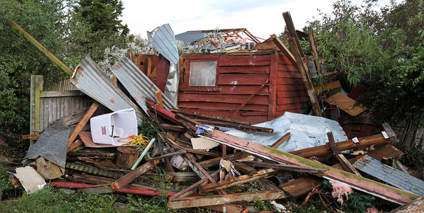
A tornado has ripped its way through North Canterbury in New Zealand as rough weather and lightning caused extensive damage. The Civil Defence has arrived at the scene to inspect the damaged properties. According to fire service shift manager Andrew Norris, a group of homes in Amberley have been heavily damaged. The town is 50km north of Christchurch. Based on fire service reports, strong winds from the tornado had lifted the tiles off roofs of homes near the Burnham Military Camp. Southern Fire Communications Shift Manager Karl Patterson said he received reports of one house losing an entire roof. The tornado, barreling its way through South Island, also knocked down trees and caused power poles to catch fire. Mr Patterson said the fire service put out fires in Halsquell Quarry which were caused by lightning. Despite the damages to some homes and power lines, no casualties or injuries were reported. The clean-up continues in tornado-damaged areas, although 30 homes reported having no electricity by the afternoon of Feb 24. A resident from Amberley, Donna Graham, told Radio New Zealand that she and her husband, Geoff, saw the tornado form from hanging black clouds and realised the twister was moving straight to her house. She and her husband began running away from the house. They could hear the noises made by the tornado as it moved. The couple came out when they noticed they could not hear the tornado anymore. Civil Defence inspector Kerry Walsh said the damage caused by the tornado was worse than he expected. He said the clean-up was doing well. South Island's lines company Mainpower remarked that some of the power poles had to be replaced before electricity will be restored to homes. Aside from the tornado in Amberley, a smaller tornado was spotted in Leeston and was captured on video by "stormchaser" Stephen Burrows. Mr Burrows said the smaller tornado was approximately 100 metres wide but looked weaker in comparison to the one in Amberley. The tornadoes were caused by a severe thunderstorm in parts of Canterbury. The MetService has warned residents in the area to prepare for a storm with torrential rain and large hail. According to weather authorities, the storm had formed near the coast of Timaru and made its way to Christchurch. The storm was classified as a "supercell" because it caused large hailstones and small tornadoes.

.....

The New Zealand Herald


Tornado strikes homes as storm lashes town


A damaged building on a plant farm near Amberley, north Canterbury. Photo / Martin Hunter
Rough weather, lightning, and reports of a tornado caused extensive damage in North Canterbury last night.
Video
Fire service shift manager Andrew Norris said a "cluster of houses" in Amberley, 50km north of Christchurch, had been badly damaged about 6.30pm.
Southern fire communications shift manager Karl Patterson said the strong winds lifted tiles off roofs near the Burnham Military Camp area and three houses in Amberley, 50km north of Christchurch, were also affected.
"One house completely lost its roof. Another house had extensive roof damage [and] windows blown in."
The weather also caused power pole fires and trees to be knocked down," Mr Patterson said.
"Apparently a tornado of some description sort of went through just near the coast - it caused a little bit of damage, but we did a check of all the houses in the area and they were ok.
"We had a couple of fires started by lightning, we had a fire in Halswell Quarry, out the south-west side of town.
"Also, in Little River we had a tree catch on fire in the middle of a tree plantation of some description."
There were no reports of injuries, Mr Patterson said.

Read More Here

.....


Enhanced by Zemanta

Monday, July 22, 2013

Damage and power blackouts in Wellington after quake of magnitude 6.9 is recorded off coast of North Island

An empty shipping container sits in the harbour where the land fell into the sea at the Port Wellington Container terminal caused by yesterdays earthquake on July 22, 2013. (AFP)

The New World supermarket in Blenheim, on New Zealand's south island, is closed after the earthquake. Photo: Emma Allen/Fairfax NZ


*************************************************************************

Earthquake rattles New Zealand capital

  • guardian.co.uk, Sunday 21 July 2013 02.55 EDT

Link to video: Earthquake hits New Zealand Capital The New Zealand capital, Wellington, was rattled by a magnitude 6.9 earthquake on Sunday that broke water mains, smashed windows and downed power lines.
Wellington police Inspector Marty Parker said there had been minor structural damage and parts of the city were left without power but there were no reports of injury and no tsunami.
The US Geological Survey said the quake happened under the Cook Strait 35 miles (57km) south-west of Wellington and six miles (10km) beneath the surface. The strait separates the main North and South Islands of New Zealand.
The quake could be felt hundreds of miles away in the centre of the North Island.
Parker said the quake struck near nightfall. A more complete picture of the damage would emerge in the morning, he said.
The Reuters news agency said the quake knocked items off shelves, shattered some windows and brought trains in Wellington to a halt. It was the largest of a series of tremors that had shaken the region in the past few days.
New Zealand is part of the so-called Pacific "Ring of Fire" that has regular seismic activity. A severe earthquake in the city of Christchurch on the South Island in 2011 killed 185 people and destroyed much of the city's downtown.

Read More and  Watch Video Here
Enhanced by Zemanta

Thursday, June 20, 2013

Extreme Weather - New Zealand, Northland, [Waikato region] : A tornado reportedly touched down in Waikato for about 10 minutes this afternoon.

Earth Watch Report  -  Extreme  Weather


....
19.06.2013Extreme WeatherNew ZealandNorthland, [Waikato region]Damage levelDetails
....

Extreme Weather in New Zealand on Wednesday, 19 June, 2013 at 08:08 (08:08 AM) UTC.

Description
A tornado reportedly touched down in Waikato for about 10 minutes this afternoon. The picture was taken at Paterangi, just south of Hamilton. While tornadoes weren't in the forecast today, unstable and slow conditions had led to the funnel cloud and then short-lived tornado, head analyst Philip Duncan said. It was at the lowest end of the scale but was still capable of lifting pieces of roofing iron and break branches. Mr Duncan said funnel clouds may be spotted over the next couple of days, along with short, sharp, squalls which are similar to tornadoes but don't spin. "This looks like a bit of a one-off as the north of New Zealand is still very much in a humid, mild, pool of unstable air - overnight it becomes more unstable but the air will get much colder and that limits the chances of further tornadoes" he said.
....

New Zealand Braces for Coming Storm in the Next Three Days


By Reissa Su | June 19, 2013 1:16 PM EST
A storm is set to hit southern and central areas of New Zealand bringing strong winds, rain and snow.  Weather reports say the storm will likely stay in the country for the next three days due to the unusual but powerful combination of weather systems.
New Zealand braces for coming storm today
New Zealand's Civil Defence urges people to prepare for emergency power outages and possible cuts to phone lines especially those living the South Island and central North Island.  The coming storm is said to be the worst one yet to hit winter so far.
Meteorologist Daniel Corbett for MetService media and communications said that people should brace for the cold winds the storm will bring.  The high amount of snowfall in Auckland two years ago may be unlikely to happen again, residents of the city are advised to remain alert since they cannot escape the coming storm.
Corbett said last Friday's temperature barely went beyond 10 degrees Celsius.  Residents will be more than likely to experience the cold blast of winds.
Read More  Here
....

Saturday, June 15, 2013

South of the Kermadec Islands 6.0 magnitude earthquake June 15th , 2013

Earth Watch Report - Earthquakes

 photo SouthoftheKermadecIslands60magnitudeearthquakeJune15th2013_zpsd206235e.jpg ....

M6.0 - South of the Kermadec Islands

2013-06-15 11:20:34 UTC

Earthquake location 33.895°S, 179.455°E

Event Time

  1. 2013-06-15 11:20:34 UTC
  2. 2013-06-15 23:20:34 UTC+12:00 at epicenter
  3. 2013-06-15 06:20:34 UTC-05:00 system time

Location

33.895°S 179.455°E depth=172.4km (107.1mi)

Nearby Cities

  1. 313km (194mi) SSW of L'Esperance Rock, New Zealand
  2. 502km (312mi) NNE of Whakatane, New Zealand
  3. 511km (318mi) ENE of Whangarei, New Zealand
  4. 514km (319mi) NE of Tauranga, New Zealand
  5. 918km (570mi) NNE of Wellington, New Zealand
....

Instrumental Intensity

ShakeMap Intensity Image ....

Tectonic Summary

Seismotectonics of the Eastern Margin of the Australia Plate

The eastern margin of the Australia plate is one of the most sesimically active areas of the world due to high rates of convergence between the Australia and Pacific plates. In the region of New Zealand, the 3000 km long Australia-Pacific plate boundary extends from south of Macquarie Island to the southern Kermadec Island chain. It includes an oceanic transform (the Macquarie Ridge), two oppositely verging subduction zones (Puysegur and Hikurangi), and a transpressive continental transform, the Alpine Fault through South Island, New Zealand. Since 1900 there have been 15 M7.5+ earthquakes recorded near New Zealand. Nine of these, and the four largest, occurred along or near the Macquarie Ridge, including the 1989 M8.2 event on the ridge itself, and the 2004 M8.1 event 200 km to the west of the plate boundary, reflecting intraplate deformation. The largest recorded earthquake in New Zealand itself was the 1931 M7.8 Hawke's Bay earthquake, which killed 256 people. The last M7.5+ earthquake along the Alpine Fault was 170 years ago; studies of the faults' strain accumulation suggest that similar events are likely to occur again. North of New Zealand, the Australia-Pacific boundary stretches east of Tonga and Fiji to 250 km south of Samoa. For 2,200 km the trench is approximately linear, and includes two segments where old (>120 Myr) Pacific oceanic lithosphere rapidly subducts westward (Kermadec and Tonga). At the northern end of the Tonga trench, the boundary curves sharply westward and changes along a 700 km-long segment from trench-normal subduction, to oblique subduction, to a left lateral transform-like structure. Australia-Pacific convergence rates increase northward from 60 mm/yr at the southern Kermadec trench to 90 mm/yr at the northern Tonga trench; however, significant back arc extension (or equivalently, slab rollback) causes the consumption rate of subducting Pacific lithosphere to be much faster. The spreading rate in the Havre trough, west of the Kermadec trench, increases northward from 8 to 20 mm/yr. The southern tip of this spreading center is propagating into the North Island of New Zealand, rifting it apart. In the southern Lau Basin, west of the Tonga trench, the spreading rate increases northward from 60 to 90 mm/yr, and in the northern Lau Basin, multiple spreading centers result in an extension rate as high as 160 mm/yr. The overall subduction velocity of the Pacific plate is the vector sum of Australia-Pacific velocity and back arc spreading velocity: thus it increases northward along the Kermadec trench from 70 to 100 mm/yr, and along the Tonga trench from 150 to 240 mm/yr. The Kermadec-Tonga subduction zone generates many large earthquakes on the interface between the descending Pacific and overriding Australia plates, within the two plates themselves and, less frequently, near the outer rise of the Pacific plate east of the trench. Since 1900, 40 M7.5+ earthquakes have been recorded, mostly north of 30°S. However, it is unclear whether any of the few historic M8+ events that have occurred close to the plate boundary were underthrusting events on the plate interface, or were intraplate earthquakes. On September 29, 2009, one of the largest normal fault (outer rise) earthquakes ever recorded (M8.1) occurred south of Samoa, 40 km east of the Tonga trench, generating a tsunami that killed at least 180 people. Across the North Fiji Basin and to the west of the Vanuatu Islands, the Australia plate again subducts eastwards beneath the Pacific, at the North New Hebrides trench. At the southern end of this trench, east of the Loyalty Islands, the plate boundary curves east into an oceanic transform-like structure analogous to the one north of Tonga. Australia-Pacific convergence rates increase northward from 80 to 90 mm/yr along the North New Hebrides trench, but the Australia plate consumption rate is increased by extension in the back arc and in the North Fiji Basin. Back arc spreading occurs at a rate of 50 mm/yr along most of the subduction zone, except near ~15°S, where the D'Entrecasteaux ridge intersects the trench and causes localized compression of 50 mm/yr in the back arc. Therefore, the Australia plate subduction velocity ranges from 120 mm/yr at the southern end of the North New Hebrides trench, to 40 mm/yr at the D'Entrecasteaux ridge-trench intersection, to 170 mm/yr at the northern end of the trench. Large earthquakes are common along the North New Hebrides trench and have mechanisms associated with subduction tectonics, though occasional strike slip earthquakes occur near the subduction of the D'Entrecasteaux ridge. Within the subduction zone 34 M7.5+ earthquakes have been recorded since 1900. On October 7, 2009, a large interplate thrust fault earthquake (M7.6) in the northern North New Hebrides subduction zone was followed 15 minutes later by an even larger interplate event (M7.8) 60 km to the north. It is likely that the first event triggered the second of the so-called earthquake "doublet". More information on regional seismicity and tectonics
....