Showing posts with label Volcanic Activity. Show all posts

Sunday, May 4, 2014

Report: Magma in Mount St. Helens on the rise

Reuters


Magma rising in Washington state's Mount St. Helens volcano: USGS

SEATTLE Thu May 1, 2014 3:35pm EDT

Visitors to the Coldwater Ridge Center look up at Mount St. Helens venting steam October 11, 2004. REUTERS/Andy Clark
Visitors to the Coldwater Ridge Center look up at Mount St. Helens venting steam October 11, 2004.
Credit: Reuters/Andy Clark
...
(Reuters) - Magma levels are slowly rebuilding inside Mount St. Helens, a volcano in Washington state that erupted in 1980 and killed 57 people, although there was no sign of an impending eruption, U.S. scientists said.
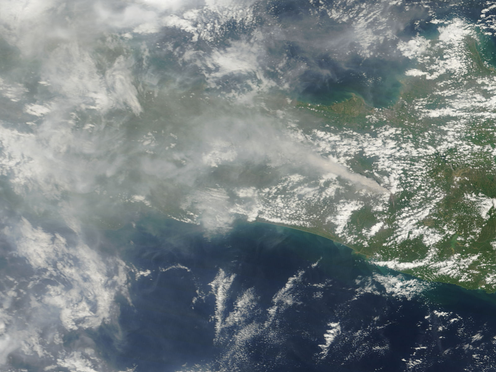
The roughly 8,300-foot volcano erupted in an explosion of hot ash and gas on May 18, 1980, spewing debris over some 230 square miles and causing more than a billion dollars in property damage. Entire forests were crushed and river systems altered in the blast, which began with a 5.2 magnitude earthquake.
"The magma reservoir beneath Mount St. Helens has been slowly re-pressurizing since 2008," the U.S. Geological Survey said in a statement on Wednesday. "It is likely that re-pressurization is caused by (the) arrival of a small amount of additional magma 4 to 8 km (2.5 to 5 miles) beneath the surface."
Read More Here

.....
Mount St. Helens erupting March 18th, 1980  by  U.S. government
Wikimedia.org
File:Mount St. Helens erupting blue.jpg

...
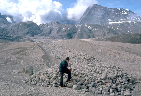
U.S. Geological Survey scientist examines pumice blocks at the edge of a pyroclastic flow from the May 18, 1980 eruption.  by  United States Geological Survey  -  Donald A. Swanson
Wikimedia.org
File:Pyroclastic Flow St. Helens.jpg
.....

Mount Saint Helens, State of Washington, United-States  7 September 2004  by  Tjk - Flickr
Wikimedia.org
File:Mount St Helens4.jpg

...

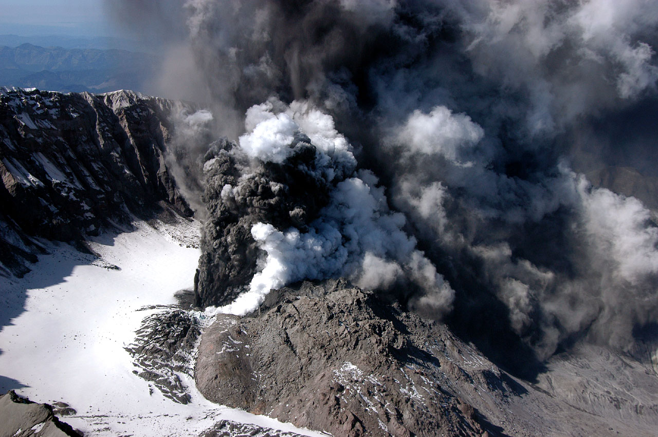
Crater / Plume image Mount St. Helens. United States Geological Survey photograph taken at 12:13:01 PDT (19:13:01 GMT) on October 1, 2004, by John Pallister
Wikimedia.org
File:MSH04 crater eruption image 1213PDT 10-01-04.jpg
.....
Mount St. Helens volcano, Washington, USA.  June 7th, 2012  by  Brigitte Werner (werner22brigitte)
Wikimedia.org
File:Mount St Helens USA 20120607.jpg
...
A panorama of Mount St. Helens  Decenber 18th ,2013  by   Eviatar Bach
Wkimedia.org
File:Panorama of Mount St. Helens.jpg
.....
Enhanced by Zemanta

Saturday, April 19, 2014

Volcano Eruption - Peru , Moquegua Region, [Ubinas Volcano]

Earth Watch Report  -  Volcanic Activity

Evacuations ordered as Peru volcano spews ash 4 km high
...
Volcano EruptionPeruMoquegua Region, [Ubinas Volcano]Damage levelDetails

.....

RSOE EDIS

Description
The Scientific Permanent Monitoring Committee and the Peruvian have declared Ubinas volcano on orange alert, meaning that local communities have to be evacuated. The volcano, which has been active again since September last year, erupted March 31, giving off ash for one thousand meters. The 20 families living in Querapi were temporarily evacuated shortly after the eruption, but are yet to be permanently relocated to Pampas de Hawái. As well as residents of Querapi, people living in Tonohaya, also in Moquegua, and San Juan de Tarucani, Arequipa, also need to be evacuated. Civil Defense chief, Miguel Alayza said that they were waiting for the alert to go from yellow to the more serious orange before they could proceed. Regional president of Moquegua, Martín Vizcarra said that the volcanic activity would affect five thousand people in that area, while in San Juan de Tarucani, Arequipa, 637 families would be affected, according to El Comercio. Ubinas volcano is considered to be the most active volcano of Peru. Eruptions have been reported since 1550.

.....

RSOE EDIS

Back
Updated:Friday, 18 April, 2014 at 04:04 UTC
Description
Peruvian authorities have ordered the preventative evacuation of 4,000 people living near the Ubinas volcano, which has been spouting ash clouds up to 4 kilometres high. The Andina state news agency quotes Agriculture Minister Juan Benites as saying it will take three days beginning today to move the residents of two southern districts and their 30,000 sheep, cows, horses, burros and other animals. Peru's health ministry says about 40 people have complained of eye inflammation and stomach problems from ash that has been falling from Ubinas since March 29. The 5,672-metre volcano is Peru's most active. It most recent strong eruption period occurred from 2006-2009.

.....

Evacuations ordered as Peru volcano spews ash 4 km high

Evacuations ordered as Peru volcano spews ash 4 km high
PanARMENIAN.Net - Peruvian authorities have ordered the preventative evacuation of 4,000 people living near the Ubinas volcano, which has been spouting ash clouds up to 2 miles (nearly 4 kilometers) high.
The Andina state news agency quotes Agriculture Minister Juan Benites as saying it will take three days beginning Thursday, April 17, to move the residents of two southern districts and their 30,000 sheep, cows, horses, burros and other animals.

Read More Here
...

Peru evacuates Ubinas volcano area after ash cloud


Footage shows huge clouds of ash escaping from Ubinas

Officials said it would take three days to move 4,000 residents and their livestock to safer grounds.
Ubinas, Peru's most active volcano, recently began spewing ash clouds up to 4km (two miles) high.
An eruption of cinder and toxic gases in 2006 killed livestock and forced a similar evacuation.

Read More Here


Related Stories

Enhanced by Zemanta

Tuesday, April 8, 2014

- Japan, Pacific Ocean, [Nishino-Shima volcano, Izu Islands]

Earth Watch Report  -  Volcanic Activity


.....
Volcano EruptionJapanPacific Ocean, [Nishino-Shima volcano, Izu Islands]Damage levelDetails

.....
Description
The ongoing eruption continues to add new land to the island with what seems a relatively steady effusion of lava flows. A new overflight by the Japanese Coast Guard shows that at least the second vent that appeared in late January is still active, feeding lava flows that continue to spread and currently have active fronts all along the eastern coast. The first original vent (cone 1, right in the picture) that build the new island and grew to a nice, symmetrical cone, seems to be inactive at present. The other vent is still active and has grown a bit since the previous overflight, with a crater that emits an ash and steam plume, presumably from mild explosive activity caused by infiltrating sea water that becomes in contact with the magma. Bluish gas on the pictures shows areas where active lava flows near their vents.
Landsat 8 infrared images from 30 March show that there are active flow fronts all along the eastern coast, while only 2 lobes are active towards the west.

.....
VolcanoDiscovery's start page

Nishino-Shima volcano (Izu Islands, Japan): lava flows continue to enlarge island

Monday Apr 07, 2014 06:24 AM | BY: T

Aerial view of Nishinoshima on  24 March 2014 (Japan Coast Guard)
Aerial view of Nishinoshima on 24 March 2014 (Japan Coast Guard)

The ongoing eruption continues to add new land to the island with what seems a relatively steady effusion of lava flows. A new overflight by the Japanese Coast Guard shows that at least the second vent that appeared in late January is still active, feeding lava flows that continue to spread and currently have active fronts all along the eastern coast.


.....
VolcanoDiscovery's start page


Part of Nishino-shima island with active flows on the southern shore, forming new bays and a small lake that once was a bay (Japan Coast guard)
Tuesday, Mar 04, 2014
The island continues to grow as lava flows slowly spread into several directions. This is shown nicely by the latest aerial survey pictures the Japanese Coast guard took on 28 Feb. The most active flow fronts are currently at the southern shore while advance on the northern and eastern margins of the flow field has slowed down. ... [more]

.....
Enhanced by Zemanta

Saturday, March 22, 2014

Volcano Activity - MultiCountries, Argentina and Chile (Andes), [Copahue Volcano]


Earth Watch Report   -  Volcanic Actuivity

Copahue volcano, quiet at the surface, today (SERNAGEOMIN webcam)
.....
Volcano ActivityMultiCountriesArgentina and Chile (Andes), [Copahue Volcano]Damage levelDetails
.....

RSOE EDIS

Description
SERNAGEOMIN raised the alert level of the volcano to orange yesterday after an increase in seismic activity. A pulse of volcanic tremor was detected that could indicate magma moving into the volcano's plumbing system. On the surface, no unusual activity has been seen at the volcano so far, except that an increase in SO2 emissions (approx 2,300 tons / day) was measured. This supports the idea that magma has risen under the edifice. Whether this activity is followed by new eruptive activity remains to be seen. In most cases, intrusions of magma under volcanoes do never reach the surface, i.e. produce eruptions. ONEMI (Civil Defense) published a bulletin stating that civil alert remains at yellow for the highest risk areas, in particular the most proximal areas around the volcano itself, but also include the city of Alto Biobío located 40 km west of the volcano, because it is at the mouth of a valley that drains Copahue on the north side and therefore, a potential pathway for mud flows that could occur during an eruption.
......

Volcano Discovery

Copahue volcano
stratovolcano 2997 m / 9,833 ft
Chile/Argentina, -37.85°S / -71.17°W
Copahue webcams / live data
Copahue volcano videos
Copahue volcano eruptions:
2013, 2012, 2001(?), 2000, 1992, 1961, 1937, 1867(?), 1759(?), 1750
Typical eruption style:
explosive
Last earthquakes nearby
......
Wednesday, Mar 12, 2014
The volcano continues to show signs of unrest. A swarm of volcanic-tectonic earthquakes occurred the day before yesterday. SERNAGEOMIN keeps the alert level of the volcano at Yellow. [more]
......
Enhanced by Zemanta

Thursday, February 27, 2014

Volcano Activity - Indonesia, West Sumatra, [Mount Merapi Volcano]

Earth Watch Report  -  Volcanic Events

 File:Merapi ash plume MODIS sat image 10 Nov 2010.jpg
Thick plume of ash rising from the Merapi Volcano on November 10, 2010 and travelling to the west. From Moderate Resolution Imaging Spectroradiometer (MODIS) on NASA’s Terra satellite, A dark brown streak down the southern face of the volcano is ash and other volcanic material deposited by a pyroclastic flow or lahar.
Author  -   NASA  public domain


.....
February 26 2014 05:34 PM Volcano Activity Indonesia West Sumatra, [Mount Merapi Volcano] Damage level Details

.....

Description
Another ash eruption occurred at the volcano this afternoon at 16:15 local time. According to local news quoting the local VSI volcano observatory spokesman, the eruption today was the largest in a series since the alert status had been raised on 3 August last year. Ash fell in a radius of 3 km where some villages are located. Also according to the article, the volcano has had a total of 57 recorded eruptions since January 2014. Since all of these have been small, and Indonesia is very used to small volcanic eruptions, they hardly make any news at all (while such an event at other volcanoes would). The alert status remains unchanged at 2 out of 4. People were recommended to avoid exposure to ash if possible and wear dust masks.

.....

Metro TV News


The Citizens Of Merapi Prompted To Be Alert


Kamis, 13 February 2014 | 15:10 WIB
ANTARA/Noveradika/ip


Metrotvnews.com, Klaten district: citizens around Merapi are asked to remain vigilant of  activity. In the meantime, residents have asked that the damaged to evacuation routes on the slopes of  the Mount  be repaired immediately.

Citizens are urged  to take precautions against disasters , the volcano's activity in some areas has increased  of late.

"Despite the conditions,  the mountain looks to still be active,  citizens who live in KRB III Merapi should remain vigilant. As the anticipated  eruptions could occur at any time, "is explained to the Indonesian Media .

The number of residents at KRB III Merapi, according to Joko,  are about 5,700 inhabitants. They are scattered throughout a number of villages in the subdistrict of Kemalang, among them  the villages of Sidorejo, Balerante, Tegalmulyo..

The government   has set up three refugee shelters in case of eruption .  Each of which has a capacity of about 2,000 people.  The  centers built  by BNPB are located in Prambanan, Karangnongko, and Kebonarum.

In the meantime, Sukamto, a 50 year old socialite in Balerante Village, has asked that the Government   repair a damaged evacuation path on the slope of Merapi.   Repairs would make for a smooth evacuation and ensure security if the mountain erupted.

In addition, the bridge that was badly damaged on the evacuation route also needs to be repaired.

Editor: Henri Solomon Siagian

.....

Merapi volcano (Sumatra, Indonesia): new ash explosions

Wednesday Feb 26, 2014 17:41 PM | BY: T

Another ash eruption occurred at the volcano this afternoon at 16:15 local time. According to local news quoting the local VSI volcano observatory spokesman, the eruption today was the largest in a series since the alert status had been raised on 3 August last year.

Read More Here


.....


Enhanced by Zemanta