Friday, June 28, 2013

Epidemic Hazard - Canada Province of Alberta, Edmonton

Earth Watch Report  -  Epidemic  Hazards


This diagram depicts the origins of the H7N9 virus from China and shows how the virus's genes came from other influenza viruses in birds.

....
TodayEpidemic HazardCanadaProvince of Alberta, EdmontonDamage level Details
....

Epidemic Hazard in Canada on Friday, 28 June, 2013 at 02:50 (02:50 AM) UTC.

Description
The Public Health Agency of Canada says an American man who ended up in an Edmonton hospital tested positive for previous infection with an H7 influenza virus.Canada's acting chief public health officer says the man is not currently ill with flu and therefore is not contagious. Dr. Gregory Taylor says, though, that the event is a reminder that viruses like the new H7N9 bird flu are only a plane ride away. The blood test used to diagnose the previous infection cannot determine the neuraminadase or N component of the virus with which the man was infected. But the infectious diseases specialist who treated him in Edmonton was on the lookout for H7N9 flu, which has infected 132 people in China this spring, killing at least 39 of them. The man had travelled in southern China in late May, though apparently not in a part of the country where human infections with H7N9 flu were recorded.
"Could he have been infected with H7N9? Maybe. We don't know for sure," Taylor says. But he notes Canada has been on heightened surveillance for the new virus and this case suggests the system is working. "It's a small world and these plane rides are short," Taylor says. The unidentified man, described as elderly, has been travelling extensively in recent weeks. Taylor says he did not know where the man was from in the United States. He travelled to China and from there to Singapore and India. The man became severely ill in India and apparently spent time in an intensive care unit in a hospital there. Taylor says he doesn't know what city that occurred in or what illness led to his hospitalization. After his release from hospital, the man travelled to Cairo, where he boarded a flight bound for San Francisco. While that flight was in the air, the man became ill and lost consciousness. The plane was diverted to Edmonton.
Taylor says the man may have suffered a diabetic coma in flight. When he landed quarantine officers assessed the case and determined that the man's symptoms did not indicate active influenza, Taylor says. Once the man was in hospital, he developed what appeared to be aspiration pneumonia - pneumonia caused by drawing in fluids to the lungs. An infectious diseases specialist at the hospital where he is being treated knew the man's travel history and ordered a battery of tests. The tests were negative for active viral infection. But the blood tests turned up evidence of a past infection with H7 flu. "The reassuring thing is that the viral tests are all negative," Taylor says. "Our understanding is he is improving and hopes to go home soon." Taylor says the Public Health Agency has been liaising with the U.S. Centers for Disease Control on the case and the U.S. agency believes it is safe for the man to return to the United States. He says Canadian authorities are also notifying counterparts in countries where the man had travelled.
Biohazard name:H7Nx
Biohazard level:4/4 Hazardous
Biohazard desc.:Viruses and bacteria that cause severe to fatal disease in humans, and for which vaccines or other treatments are not available, such as Bolivian and Argentine hemorrhagic fevers, H5N1(bird flu), Dengue hemorrhagic fever, Marburg virus, Ebola virus, hantaviruses, Lassa fever, Crimean-Congo hemorrhagic fever, and other hemorrhagic or unidentified diseases. When dealing with biological hazards at this level the use of a Hazmat suit and a self-contained oxygen supply is mandatory. The entrance and exit of a Level Four biolab will contain multiple showers, a vacuum room, an ultraviolet light room, autonomous detection system, and other safety precautions designed to destroy all traces of the biohazard. Multiple airlocks are employed and are electronically secured to prevent both doors opening at the same time. All air and water service going to and coming from a Biosafety Level 4 (P4) lab will undergo similar decontamination procedures to eliminate the possibility of an accidental release.
Symptoms: 
Status:suspected
....

CALGARY HERALD

Plane diverts to Edmonton with sick patient; tests show man had H7 flu


Plane diverts to Edmonton with sick patient; tests show man had H7 flu

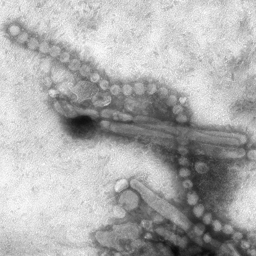
This April 15, 2013 electron microscope image provided by the Centers for Disease Control and Prevention shows the H7N9 virus which can take on a variety of shapes. THE CANADIAN PRESS/AP, CDC, C.S. Goldsmith, T. Rowe

The Public Health Agency of Canada says an American man who ended up in an Edmonton hospital tested positive for previous infection with an H7 influenza virus.
Canada's acting chief public health officer says the man is not currently ill with flu and therefore is not contagious.
Dr. Gregory Taylor says, though, that the event is a reminder that viruses like the new H7N9 bird flu are only a plane ride away.
The blood test used to diagnose the previous infection cannot determine the neuraminadase or N component of the virus with which the man was infected.
But the infectious diseases specialist who treated him in Edmonton was on the lookout for H7N9 flu, which has infected 132 people in China this spring, killing at least 39 of them.
The man had travelled in southern China in late May, though apparently not in a part of the country where human infections with H7N9 flu were recorded.
"Could he have been infected with H7N9? Maybe. We don't know for sure," Taylor says.


Read More Here
....

Pacific Ocean - Tropical Depression (06W) June 28th, 2013

Earth Watch Report  -  Storms


 photo TropicalDepression06WJune28th2013_zpsb484ab54.jpg
....
  Active tropical storm system(s)
06WPacific Ocean27.06.201328.06.2013Tropical Depression280 °46 km/h65 km/h3.05 mJTWCDetails
Name of storm systemLocationFormedLast updateLast categoryCourseWind SpeedGustWaveSourceDetails
....

Tropical Storm data

Share: 
Storm name:06W
Area:Pacific Ocean
Start up location:N 9° 18.000, E 129° 12.000
Start up:28th June 2013
Status:Active
Track long:0.00 km
Top category.: 
Report by:JTWC
Useful links:
 
Past track
DateTimePositionSpeed
km/h
Wind
km/h
Gust
km/h
CategoryCourseWavePressureSource
 
Current position
DateTimePositionSpeed
km/h
Wind
km/h
Gust
km/h
CategoryCourseWave
feet
PressureSource
28th Jun 201305:29:10N 9° 18.000, E 129° 12.000194665Tropical Depression280 °10 JTWC
 
Forecast track
DateTimePositionCategoryWind
km/h
Gust
km/h
Source
29th Jun 201300:00:00N 11° 36.000, E 125° 42.000Tropical Depression5674JTWC
29th Jun 201312:00:00N 13° 30.000, E 123° 36.000Tropical Depression5674JTWC
30th Jun 201300:00:00N 15° 12.000, E 121° 24.000Tropical Depression5674JTWC
01st Jul 201300:00:00N 19° 6.000, E 116° 0.000Tropical Depression6583JTWC
02nd Jul 201300:00:00N 22° 30.000, E 113° 54.000Tropical Depression5674JTWC
03rd Jul 201300:00:00N 26° 18.000, E 112° 36.000Tropical Depression3756JTWC
....

Pacific Ocean - East : Tropical Depression Cosme (03E) June 28th, 2013

Earth Watch Report  -  Storms


Hurricane COSME NHC 5-Day Cone
Hurricane COSME
NHC 5-Day Cone
....
  Active tropical storm system(s)
Name of storm systemLocationFormedLast updateLast categoryCourseWind SpeedGustWaveSourceDetails
Cosme (03E)Pacific Ocean - East22.06.201327.06.2013Tropical Depression285 °65 km/h83 km/h4.27 mNOAA NHCDetails
....

 photo TropicalDepressionCosme03EJune28th2013_zps4f3fba52.jpg
....

 Tropical Storm data

Share: 
Storm name:Cosme (03E)
Area:Pacific Ocean - East
Start up location:N 11° 48.000, W 103° 48.000
Start up:23rd June 2013
Status:Active
Track long:1,277.96 km
Top category.: 
Report by:NOAA NHC
Useful links:
 
Past track
DateTimePositionSpeed
km/h
Wind
km/h
Gust
km/h
CategoryCourseWavePressureSource
24th Jun 201307:12:49N 12° 36.000, W 104° 24.000115674Tropical Depression315121005 MBNOAA NHC
25th Jun 201304:45:47N 15° 54.000, W 107° 54.00022102120Tropical Storm30512994 MBNOAA NHC
26th Jun 201304:54:45N 17° 54.000, W 113° 18.00022139167Hurricane I.29012981 MBNOAA NHC
27th Jun 201305:19:35N 19° 36.000, W 117° 36.0002283102Tropical Storm29512998 MBNOAA NHC
 
Current position
DateTimePositionSpeed
km/h
Wind
km/h
Gust
km/h
CategoryCourseWave
feet
PressureSource
27th Jun 201317:23:33N 20° 24.000, W 120° 54.000266583Tropical Depression285 °141003 MBNOAA NHC
 
Forecast track
DateTimePositionCategoryWind
km/h
Gust
km/h
Source
29th Jun 201306:00:00N 21° 48.000, W 130° 0.000Tropical Depression3756NOAA NHC
30th Jun 201306:00:00N 21° 48.000, W 134° 30.000Tropical Depression3756NOAA NHC
01st Jul 201306:00:00N 22° 0.000, W 139° 0.000Tropical Depression3756NOAA NHC
....

Volcano Activity - State of Alaska, [Mount Pavlof Volcano]

Earth Watch Report  -  Volcanic  Activity

Pavlof Volcano
Pavlof eruption, May 18, 2013 Photo courtesy of Brandon Wilson/Alaska Volcano Observatory 

....
28.06.2013Volcano ActivityUSAState of Alaska, [Mount Pavlof Volcano]Damage level Details
....

Volcano Activity in USA on Sunday, 23 June, 2013 at 04:37 (04:37 AM) UTC.

Back
Updated:Wednesday, 26 June, 2013 at 02:56 UTC
Description
Pavlof Volcano, on the Alaska Peninsula, spewed a 26,000-foot ash cloud early Tuesday morning. That's the largest plume the volcano has put up since it started erupting in early May.At that elevation, it isn't interfering with international air traffic passing over the region, but it is proving problematic for regional air service. According to the terminal agent in Cold Bay, PenAir turned around a cargo run to the community this morning, and canceled its passenger flight as well. Unalaska's passenger flights are running as scheduled, according to station manager Lowell Crezee, and shouldn't be impacted by the eruption. PenAir's main office couldn't be reached for information about flights to other communities. The National Weather Service has issued an ash advisory for the Alaska Peninsula, but so far, there have been no reports of ashfall. And according to Alaska Volcano Observatory geophysicist Dave Schneider, there likely won't be. "The direction it's heading, it's not really heading toward any of the villages," Schneider says. "It's a little bit east of Nelson Lagoon, and to the west of Port Heiden. So it's in a place where there's not really a lot of people.” Schneider says the volcano is still showing signs of increased activity, and could put up more ash plumes at any time. Pavlof is the most active volcano in Alaska, and has previously erupted for weeks, or even months, at a time, although it typically cycles through periods of intense activity, like the current one.
....

Volcano Activity in USA on Sunday, 23 June, 2013 at 04:37 (04:37 AM) UTC.

Back
Updated:Friday, 28 June, 2013 at 02:57 UTC
Description
An active volcano in Anchorage, Alaska, that has been spewing ash and lava for the past six weeks reached new levels of intensity on Tuesday as reports indicate that the cinders were shot 5 miles into sky and landed in a nearby town. The eruptions from Pavlof Volcano, on the Alaskan Peninsula about 590 miles southwest of Anchorage, were its most powerful since it started showing seismic activity in mid-May, scientists at the federal-state Alaska Volcano Observatory said. The latest series of more-powerful ash-producing blasts from the crater of the 8,261-foot (2,518-meter) volcano started late on Monday and continued overnight into Tuesday, scientists said. The ash reportedly reached heights of 28,000 feet at times, disrupting several commercial flights. Anchorage-based PenAir canceled one flight and rerouted others, an official confirmed. In addition, debris has fallen over King Cove, a town of about 900 people located 30 miles southwest of Pavlof, scientists said. The National Weather Service issued an ash advisory for the region, warning of breathing problems for people with respiratory ailments and potential damage to exposed electronic equipment.
....

Alaska Volcano Eruption Shoots Cinders 5 Miles High, Disprupts Several Commercial Flights 

on June 27 2013 8:25 AM
Pavlof Volcano

Pavlof eruption, May 18, 2013 Photo courtesy of Brandon Wilson/Alaska Volcano Observatory
An active volcano in Anchorage, Alaska, that has been spewing ash and lava for the past six weeks reached new levels of intensity on Tuesday as reports indicate that the cinders were shot 5 miles into sky and landed in a nearby town.

The eruptions from Pavlof Volcano, on the Alaskan Peninsula about 590 miles southwest of Anchorage, were its most powerful since it started showing seismic activity in mid-May, scientists at the federal-state Alaska Volcano Observatory said.
The latest series of more-powerful ash-producing blasts from the crater of the 8,261-foot (2,518-meter) volcano started late on Monday and continued overnight into Tuesday, scientists said.
The ash reportedly reached heights of 28,000 feet at times, disrupting several commercial flights. Anchorage-based PenAir canceled one flight and rerouted others, an official confirmed to Reuters.


Read More Here
....

Tuesday, June 25, 2013

Earth approaching objects - Tuesday June 25th , 2013

Earth Watch Report  -  Space

Image Source  NASA
....

Earth approaching objects (objects that are known in the next 30 days)

 
Object Name Apporach Date Left AU Distance LD Distance Estimated Diameter* Relative Velocity
(2002 LT24)24th June 20130 day(s)0.059223.0110 m - 250 m8.96 km/s32256.000000000004 km/h
(2011 DL19)24th June 20130 day(s)0.182871.1430 m - 960 m19.82 km/s71352 km/h
(2013 LE1)24th June 20130 day(s)0.124948.677 m - 170 m11.11 km/s39996 km/h
(2010 NY65)25th June 20131 day(s)0.063524.7120 m - 270 m13.98 km/s50328 km/h
163249 (2002 GT)25th June 20131 day(s)0.120246.8580 m - 1.3 km8.76 km/s31536 km/h
(2010 GA24)26th June 20132 day(s)0.135552.7170 m - 370 m9.03 km/s32507.999999999996 km/h
(2013 BP15)26th June 20132 day(s)0.187973.137 m - 84 m9.33 km/s33588 km/h
293726 (2007 RQ17)27th June 20133 day(s)0.035713.983 m - 190 m5.92 km/s21312 km/h
(2012 MD7)29th June 20135 day(s)0.164964.241 m - 92 m7.99 km/s28764 km/h
(2008 WM64)29th June 20135 day(s)0.190474.1200 m - 460 m17.44 km/s62784.00000000001 km/h
(2003 RU11)30th June 20136 day(s)0.193175.120 m - 45 m9.22 km/s33192 km/h
(2011 BN24)30th June 20136 day(s)0.114544.5170 m - 380 m7.71 km/s27756 km/h
(2013 CE129)01st July 20137 day(s)0.099138.6100 m - 220 m5.89 km/s21204 km/h
(2008 NP3)01st July 20137 day(s)0.197176.757 m - 130 m6.32 km/s22752 km/h
(2004 YG1)02nd July 20138 day(s)0.101939.6140 m - 310 m12.18 km/s43848 km/h
(2008 TD)03rd July 20139 day(s)0.137353.423 m - 52 m6.82 km/s24552 km/h
(2009 HU44)03rd July 20139 day(s)0.117045.584 m - 190 m17.32 km/s62352 km/h
(2005 HN3)04th July 201310 day(s)0.121247.2160 m - 350 m10.48 km/s37728 km/h
(2010 WR7)05th July 201311 day(s)0.175068.154 m - 120 m12.02 km/s43272 km/h
7753 (1988 XB)09th July 201315 day(s)0.118346.0510 m - 1.1 km10.19 km/s36684 km/h
(2012 HN1)10th July 201316 day(s)0.149658.211 m - 24 m4.89 km/s17604 km/h
(2006 NL)10th July 201316 day(s)0.137953.6300 m - 680 m15.51 km/s55836 km/h
(2012 LA11)12th July 201318 day(s)0.092636.016 m - 35 m2.78 km/s10008 km/h
(2010 MJ1)12th July 201318 day(s)0.197376.852 m - 120 m11.08 km/s39888 km/h
(2010 AF30)14th July 201320 day(s)0.045717.8140 m - 300 m9.69 km/s34884 km/h
153349 (2001 PJ9)16th July 201322 day(s)0.075129.2660 m - 1.5 km17.79 km/s64044 km/h
(2010 AF3)16th July 201322 day(s)0.055221.516 m - 36 m7.63 km/s27468 km/h
(2011 KP16)17th July 201323 day(s)0.089534.823 m - 51 m7.02 km/s25272 km/h
(2012 AM10)17th July 201323 day(s)0.052120.373 m - 160 m15.87 km/s57132 km/h
(2011 WU95)20th July 201326 day(s)0.109042.4360 m - 800 m7.24 km/s26064 km/h
(2007 XY9)21st July 201327 day(s)0.075929.5170 m - 370 m13.86 km/s49896 km/h
(2013 BN18)21st July 201327 day(s)0.064625.131 m - 70 m8.24 km/s29664 km/h
(2008 MG1)23rd July 201329 day(s)0.157461.2290 m - 650 m29.02 km/s104472 km/h
1 AU = ~150 million kilometers,1 LD = Lunar Distance = ~384,000 kilometers Source: NASA-NEO

...


Pacific Ocean - East : Tropical Depression Cosme (03E)

Earth Watch Report - Storms

 
Tropical Storm COSME NHC 5-Day Cone Tropical Storm 03E (COSME) JTWC ATCF Track
Tropical Storm COSME NHC 5-Day Cone           Tropical Storm 03E (COSME) JTWC ATCF Track
...
Active tropical storm system(s)
Name of storm system Location Formed Last update Last category Course Wind Speed Gust Wave Source Details
Cosme (03E) Pacific Ocean - East 22.06.2013 25.06.2013 Tropical Depression 305 ° 102 km/h 120 km/h 3.66 m NOAA NHC Details
...  photo TropicalDepressionCosme03EJune24th2013_zps961f0caa.jpg ...

Tropical Storm data

Share:
Storm name: Cosme (03E)
Area: Pacific Ocean - East
Start up location: N 11° 48.000, W 103° 48.000
Start up: 23rd June 2013
Status: Active
Track long: 394.64 km
Top category.:
Report by: NOAA NHC
Useful links:
Past track
Date Time Position Speed km/h Wind km/h Gust km/h Category Course Wave Pressure Source
24th Jun 2013 07:12:49 N 12° 36.000, W 104° 24.000 11 56 74 Tropical Depression 315 12 1005 MB NOAA NHC
Current position
Date Time Position Speed km/h Wind km/h Gust km/h Category Course Wave feet Pressure Source
25th Jun 2013 04:45:47 N 15° 54.000, W 107° 54.000 22 102 120 Hurricane I 305 ° 12 994 MB NOAA NHC
Forecast track
Date Time Position Category Wind km/h Gust km/h Source
26th Jun 2013 00:00:00 N 17° 24.000, W 112° 6.000 Hurricane II 139 167 NOAA NHC
26th Jun 2013 12:00:00 N 18° 0.000, W 114° 30.000 Hurricane II 130 157 NOAA NHC
27th Jun 2013 00:00:00 N 18° 42.000, W 116° 54.000 Hurricane I 111 139 NOAA NHC
28th Jun 2013 00:00:00 N 20° 0.000, W 122° 0.000 Tropical Depression 74 93 NOAA NHC
29th Jun 2013 00:00:00 N 20° 30.000, W 127° 0.000 Tropical Depression 46 65 NOAA NHC
30th Jun 2013 00:00:00 N 20° 30.000, W 132° 0.000 Tropical Depression 46 65 NOAA NHC
... ...

Power Outage - State of Nebraska, Omaha : A severe thunderstorm hit the Omaha metro area around 10 am packing 70 mph winds and heavy rain. About 5,000 customers are without electricity

Earth Watch Report  -  Power  Outage - Storms


See Additional Photos Here

....
25.06.2013Power OutageUSAState of Nebraska, OmahaDamage level Details
....

Power Outage in USA on Monday, 24 June, 2013 at 18:02 (06:02 PM) UTC.

Description
A severe thunderstorm hit the Omaha metro area around 10 am packing 70 mph winds and heavy rain. Those strong winds downed trees, power lines and caused outages throughout Douglas and Sarpy Counties. There are reports of trees down all over the city blocking streets and bringing down power lines. Omaha Fire Department units are busy responding to calls of smoldering tree limbs on power lines. Omaha Public Power District perhaps has the biggest job ahead of them. Nearly 50,000 customers are without service. Loss of service also means traffic lights are not working and that is causing backups throughout the entire metro area. The storm also impacted Council Bluffs and most intersections there are also four-way stops. There were reports of trees down at several locations in that city as well. MidAmerican Energy is reporting is reporting that about 5,000 customers are without service.
....


'Intense' morning storm causes power outages, tree damage around Omaha


A summer storm that blasted through the Omaha metropolitan area Monday morning downing trees and power lines came about when several thunderstorms joined forces about 4 a.m. in eastern Nebraska.

Frank Strait, a meteorologist with AccuWeather, The World-Herald's private weather consultant, said forecasters had been predicting chances of thunderstorms, but they “were caught off guard” by the strength of the severe weather.

“We knew there was a good chance of thunderstorms popping up, but what we got was a cluster of thunderstorms organizing into a squall line with high winds in the eastern part of the state,” Strait said. “That made everything more intense.”
More photos: Storm damages trees around Omaha
Scott Dergan, of the National Weather Service in Valley, said the storm began with winds of 40 mph on the western edge of Douglas County about 10 a.m. By the time the storm reached Eppley Airfield on the eastern boundary of the county 45 minutes later, winds there were clocked at 69 mph.

The storm continued through Iowa, with Harlan reporting winds of 75 mph, Dergan said. The line of thunderstorms was expected to hit Chicago late Monday or early Tuesday.

“A lot of times storms like this take time to brew before they get what we call water loaded, and then they accelerate,” Dergan said. “It was nothing specific about the metro area such as the urban heat island effect. It was just Mother Nature.”


Read More Here
....