Showing posts with label Pacific. Show all posts

Friday, February 28, 2014

Alaska - 6.1 Magnitude Earthquake - 138km NNW of Amukta Island

M 6.1 - 138km NNW of Amukta Island, Alaska

 2014-02-26 21:13:40 UTC


Earthquake location 53.679°N, 171.837°W

Event Time

  1. 2014-02-26 21:13:40 UTC
  2. 2014-02-26 10:13:40 UTC-11:00 at epicenter
  3. 2014-02-26 15:13:40 UTC-06:00 system time

Location

53.679°N 171.837°W depth=264.7km (164.5mi)

Nearby Cities

  1. 138km (86mi) NNW of Amukta Island, Alaska
  2. 1371km (852mi) SSE of Anadyr', Russia
  3. 1550km (963mi) WSW of Anchorage, Alaska
  4. 1578km (981mi) WSW of Knik-Fairview, Alaska
  5. 2321km (1442mi) W of Whitehorse, Canada

.....

Instrumental Intensity

ShakeMap Intensity Image

.....

Tectonic Summary

Seismotectonics of Alaska

The Aleutian arc extends approximately 3,000 km from the Gulf of Alaska in the east to the Kamchatka Peninsula in the west. It marks the region where the Pacific plate subducts into the mantle beneath the North America plate. This subduction is responsible for the generation of the Aleutian Islands and the deep offshore Aleutian Trench.
The curvature of the arc results in a westward transition of relative plate motion from trench-normal (i.e., compressional) in the east to trench-parallel (i.e., translational) in the west, accompanied by westward variations in seismic activity, volcanism, and overriding plate composition. The Aleutian arc is generally divided into three regions: the western, central, and eastern Aleutians. Relative to a fixed North America plate, the Pacific plate is moving northwest at a rate that increases from roughly 60 mm/yr at the arc's eastern edge to 76 mm/yr near its western terminus. The eastern Aleutian arc extends from the Alaskan Peninsula in the east to the Fox Islands in the west. Motion along this section of the arc is characterized by arc-perpendicular convergence and Pacific plate subduction beneath thick continental lithosphere. This region exhibits intense volcanic activity and has a history of megathrust earthquakes.
The central Aleutian arc extends from the Andreanof Islands in the east to the Rat Islands in the west. Here, motion is characterized by westward-increasing oblique convergence and Pacific plate subduction beneath thin oceanic lithosphere. Along this portion of the arc, the Wadati-Benioff zone is well defined to depths of approximately 200 km. Despite the obliquity of convergence, active volcanism and megathrust earthquakes are also present along this margin.
The western Aleutians, stretching from the western end of the Rat Islands in the east to the Commander Islands, Russia, in the west, is tectonically different from the central and eastern portions of the arc. The increasing component of transform motion between the Pacific and North America plates is evidenced by diminishing active volcanism; the last active volcano is located on Buldir Island, in the far western portion of the Rat Island chain. Additionally, this portion of the subduction zone has not hosted large earthquakes or megathrust events in recorded history. Instead, the largest earthquakes in this region are generally shallow, predominantly strike-slip events with magnitudes between M5-6. Deeper earthquakes do occur, albeit rather scarcely and with small magnitudes (M<4), down to approximately 50 km.
Most of the seismicity along the Aleutian arc results from thrust faulting that occurs along the interface between the Pacific and North America plates, extending from near the base of the trench to depths of 40 to 60 km. Slip along this interface is responsible for generating devastating earthquakes. Deformation also occurs within the subducting slab in the form of intermediate-depth earthquakes that can reach depths of 250 km. Normal faulting events occur in the outer rise region of the Aleutian arc resulting from the bending of the oceanic Pacific plate as it enters the Aleutian trench. Additionally, deformation of the overriding North America plate generates shallow crustal earthquakes.
The Aleutian arc is a seismically active region, evidenced by the many moderate to large earthquakes occurring each year. Since 1900, this region has hosted twelve large earthquakes (M>7.5) including the May 7, 1986 M8.0 Andreanof Islands, the June 10, 1996 M7.9 Andreanof Islands, and the November 17, 2003 M7.8 Rat Islands earthquakes. Six of these great earthquakes (M8.3 or larger) have occurred along the Aleutian arc that together have ruptured almost the entire shallow megathrust contact. The first of these major earthquakes occurred on August 17, 1906 near the island of Amchitka (M8.3) in the western Aleutian arc. However, unlike the other megathrust earthquakes along the arc, this event is thought to have been an intraplate event occurring in the shallow slab beneath the subduction zone interface.
The first megathrust event along the arc during the 20th century was the November 10, 1938 M8.6 Shumagin Island earthquake. This event ruptured an approximately 300 km long stretch of the arc from the southern end of Kodiak Island to the northern end of the Shumagin Islands and generated a small tsunami that was recorded as far south as Hawaii.
The April 1, 1946 M8.6 Unimak Island earthquake, located in the central Aleutian arc, was characterized by slow rupture followed by a devastating Pacific-wide tsunami that was observed as far south as the shores of Antarctica. Although damage from earthquake shaking was not severe locally, tsunami run-up heights were recorded as high as 42 m on Unimak Island and tsunami waves in Hilo, Hawaii also resulted in casualties. The slow rupture of this event has made it difficult to constrain the focal mechanism and depth of the earthquake, though it is thought to have been an interplate thrust earthquake.
The next megathrust earthquake occurred along the central portion of the Aleutian arc near the Andreanof Islands on March 9, 1957, with a magnitude of M8.6. The rupture length of this event was approximately 1200 km, making it the longest observed aftershock zone of all the historic Aleutian arc events. Although only limited seismic data from this event are still available, significant damage and tsunamis were observed on the islands of Adak and Unimak with tsunami heights of approximately 13 m.
The easternmost megathrust earthquake was the March 28, 1964 M9.2 Prince William Sound earthquake, currently the second largest recorded earthquake in the world. The event had a rupture length of roughly 700 km extending from Prince William Sound in the northeast to the southern end of Kodiak Island in the southwest. Extensive damage was recorded in Kenai, Moose Pass, and Kodiak but significant shaking was felt over a large region of Alaska, parts of western Yukon Territory, and British Columbia, Canada. Property damage was the largest in Anchorage, as a result of both the main shock shaking and the ensuing landslides. This megathrust earthquake also triggered a devastating tsunami that caused damage along the Gulf of Alaska, the West Coast of the United States, and in Hawaii.
The westernmost Aleutians megathrust earthquake followed a year later on February 4, 1965. This M8.7 Rat Islands earthquake was characterized by roughly 600 km of rupture. Although this event is quite large, damage was low owing to the region's remote and sparsely inhabited location. A relatively small tsunami was recorded throughout the Pacific Ocean with run-up heights up to 10.7 m on Shemya Island and flooding on Amchitka Island.
Although the Aleutian arc is highly active, seismicity is rather discontinuous, with two regions that have not experienced a large (M>8.0) earthquake in the past century: the Commander Islands in the western Aleutians and the Shumagin Islands in the east. Due to the dominantly transform motion along the western arc, there is potential that the Commander Islands will rupture in a moderate to large strike-slip earthquake in the future. The Shumagin Islands region may also have high potential for hosting a large rupture in the future, though it has been suggested that little strain is being accumulated along this section of the subduction zone, and thus associated hazards may be reduced.
East of the Aleutian arc along the Gulf of Alaska, crustal earthquakes occur as a result transmitted deformation and stress associated with the northwestward convergence of the Pacific plate that collides a block of oceanic and continental material into the North America plate. In 2002, the Denali Fault ruptured in a sequence of earthquakes that commenced with the October 23 M6.7 Nenana Mountain right-lateral strike-slip earthquake and culminated with the November 3, M7.9 Denali earthquake which started as a thrust earthquake along a then unrecognized fault and continued with a larger right-lateral strike-slip event along the Denali and Totschunda Faults.
More information on regional seismicity and tectonics

.....

Alaska Dispatch

Big 6.1 quake shakes Alaska in Aleutians:


A 6.1 earthquake shook the Alaska communities of Nikolski and Unalaska Wednesday, according to the Alaska Earthquake Center. The strong shake occurred around noon in the Bering Sea region of the state. The center says the earthquake had a preliminary magnitude of 6.1 and was located at a depth of 23 miles. The towns, located near the mid-section of the arc of the Aleutian Islands stretching more than 1,000 miles toward Asia, reportedly didn’t suffer any damages. Quakes with magnitudes of about 4.5 or greater are strong enough to be recorded by sensitive seismographs worldwide. Great earthquakes, such as Alaska's 1964 Good Friday earthquake, have magnitudes of 8.0 or higher. The U.S. Geological Survey says that on average, one earthquake of that size occurs somewhere in the world each year.

.....
Enhanced by Zemanta

Wednesday, February 26, 2014

Fukushima radioactive plume due to reach West Coast this spring. One Model predicts a maximum concentration of 27 becquerels per cubic metre of water on the Canadian coast by mid-2015


Scientists say lack of government supported research forcing them to use volunteers, predictive models

- Lauren McCauley, staff writer

An image from a model of the progression of a radioactive plume coming across the Pacific following the Fukushima nuclear meltdown. (via BBC News)A radioactive plume released from the Fukushima meltdown is expected to reach the west coast of the U.S. in April, said a panel of researchers in Honolulu Monday. However, without any federal or international monitoring, scientists are bereft of "actual data," guessing at the amount of radiation coming at us.
Monitors along the Pacific U.S. coast have yet to detect any traces of cesium-134, said Ken Buesseler, a chemical oceanographer at the Woods Hole Oceanographic Institution (WHOI), speaking on a panel at the meeting of the American Geophysical Union's Ocean Sciences. However, sampling undertaken by Dr. John Smith at the Bedford Institute of Oceanography has helped develop models that forecast the "probable future progression of the plume."
According to Buesseler, initial traces should be detectable along the Pacific coast in April.
One of the radioactive isotopes that is formed during a nuclear accident is cesium-134. With a short half-life of two years, any traces of it detected by monitoring instruments can be specifically attributed to the Fukushima nuclear accident.
Another isotope, cesium-137, decays very slowly with a half-life of 30 years. Though traces of cesium-137 have been detected in the world's oceans, their source may be attributed to previous nuclear-weapons tests.
One shortcoming of the current models available to the scientists is that lack of solid data is creating varying predictions about the amount of radiation and when it is expected to reach the west coast. And though the estimated levels fall far shorter than acceptable drinking water concentrations, according to the WHOI, the concern is not direct exposure but rather the "uptake by the food web and, hence, the potential for human consumption of contaminated fish."
"To my mind, this is not really acceptable," said Buesseler, speaking of the variation between the predictive models. "We need better studies and resources to do a better job, because there are many reactors on coasts and rivers and if we can’t predict within a factor of 10 what cesium or some other isotope is downstream—I think that’s a pretty poor job."
Individuals have recently spread alarm about the presence of radioactive isotopes already found along the Pacific coast, although those concerns were debunked.
Without any federal or international agencies currently monitoring ocean waters from Fukushima on this side of the Pacific, Buesseler and the WHOI have had to recruit volunteers to collect seawater at 16 sites along the California and Washington coasts and two in Hawaii and ship the samples back to the Cape Cod, Mass. laboratory.
"We need to know the real levels of radiation coming at us," said Bing Dong, a retired accountant and one of the volunteers with the WHOI project. "There's so much disinformation out there, and we really need actual data."
_____________________

Radioactive water travelling from Fukushima power plant being measured by scientists


Researchers are attempting to predict the amount of radioactive water from Japan that will hit the North American coast.

The concentration of radioactive water from the Fukushima power plant in Japan expected to hit North American coasts should be known in the next two months.
So far only small traces of pollution have been recorded in Canadian continental waters, but this is expected to increase as contaminants move eastwards on Pacific currents, BBC News has reported.
In 2011, three nuclear reactors at the Japanese facility went into meltdown, leaking radiation into the Pacific Ocean.
Researchers from the Bedford Institute of Oceanography in Canada have been analysing water along a line running almost 2,000km due west of Vancouver, British Columbia, since the 2011 Fukushima accident.
In June 2013, radioactive caesium-137 and 134 were detected in the entire line of the sampling length.
Scientists stress that even with the probable increases taken into account, the measurements will be well within limits set by safety authorities.
Researchers have harnessed the radioactive water to test two forecasting models to try and map the probable future progression of the plume of radioactive water.
Using one model, the scientists have predicted that a maximum concentration of 27 becquerels per cubic metre of water will appear on the Canadian coast by mid-2015, but the other model predicts no more than about two becquerels per cubic metre of water.
Bedford’s Dr John Smith told BBC News that further measurements currently being taken in the ocean should give researchers a fair idea of which model is correct.
Read More Here


Enhanced by Zemanta

Monday, September 30, 2013

New Zealand - 6.7 Magnitude Earthquake - 81km NE of L'Esperance Rock

Earth Watch Report  -  Earthquakes


 photo NewZealand-67magEQ9302013_zpseae26fc0.jpg
...

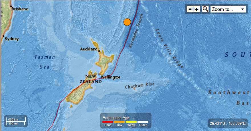
M 6.7 - 81km NE of L'Esperance Rock, New Zealand

 2013-09-30 05:55:54 UTC


Earthquake location 30.956°S, 178.244°W

Event Time

  1. 2013-09-30 05:55:54 UTC
  2. 2013-09-29 17:55:54 UTC-12:00 at epicenter
  3. 2013-09-30 00:55:54 UTC-05:00 system time

Location

30.956°S 178.244°W depth=34.8km (21.6mi)

Nearby Cities

  1. 81km (50mi) NE of L'Esperance Rock, New Zealand
  2. 870km (541mi) NE of Whangarei, New Zealand
  3. 891km (554mi) NNE of Whakatane, New Zealand
  4. 906km (563mi) NE of Tauranga, New Zealand
  5. 1129km (702mi) SSW of Nuku`alofa, Tonga
...

Instrumental Intensity

ShakeMap Intensity Image
...

Tectonic Summary

Seismotectonics of the Eastern Margin of the Australia Plate

The eastern margin of the Australia plate is one of the most sesimically active areas of the world due to high rates of convergence between the Australia and Pacific plates. In the region of New Zealand, the 3000 km long Australia-Pacific plate boundary extends from south of Macquarie Island to the southern Kermadec Island chain. It includes an oceanic transform (the Macquarie Ridge), two oppositely verging subduction zones (Puysegur and Hikurangi), and a transpressive continental transform, the Alpine Fault through South Island, New Zealand.
Since 1900 there have been 15 M7.5+ earthquakes recorded near New Zealand. Nine of these, and the four largest, occurred along or near the Macquarie Ridge, including the 1989 M8.2 event on the ridge itself, and the 2004 M8.1 event 200 km to the west of the plate boundary, reflecting intraplate deformation. The largest recorded earthquake in New Zealand itself was the 1931 M7.8 Hawke's Bay earthquake, which killed 256 people. The last M7.5+ earthquake along the Alpine Fault was 170 years ago; studies of the faults' strain accumulation suggest that similar events are likely to occur again.
North of New Zealand, the Australia-Pacific boundary stretches east of Tonga and Fiji to 250 km south of Samoa. For 2,200 km the trench is approximately linear, and includes two segments where old (>120 Myr) Pacific oceanic lithosphere rapidly subducts westward (Kermadec and Tonga). At the northern end of the Tonga trench, the boundary curves sharply westward and changes along a 700 km-long segment from trench-normal subduction, to oblique subduction, to a left lateral transform-like structure.
Australia-Pacific convergence rates increase northward from 60 mm/yr at the southern Kermadec trench to 90 mm/yr at the northern Tonga trench; however, significant back arc extension (or equivalently, slab rollback) causes the consumption rate of subducting Pacific lithosphere to be much faster. The spreading rate in the Havre trough, west of the Kermadec trench, increases northward from 8 to 20 mm/yr. The southern tip of this spreading center is propagating into the North Island of New Zealand, rifting it apart. In the southern Lau Basin, west of the Tonga trench, the spreading rate increases northward from 60 to 90 mm/yr, and in the northern Lau Basin, multiple spreading centers result in an extension rate as high as 160 mm/yr. The overall subduction velocity of the Pacific plate is the vector sum of Australia-Pacific velocity and back arc spreading velocity: thus it increases northward along the Kermadec trench from 70 to 100 mm/yr, and along the Tonga trench from 150 to 240 mm/yr.
The Kermadec-Tonga subduction zone generates many large earthquakes on the interface between the descending Pacific and overriding Australia plates, within the two plates themselves and, less frequently, near the outer rise of the Pacific plate east of the trench. Since 1900, 40 M7.5+ earthquakes have been recorded, mostly north of 30°S. However, it is unclear whether any of the few historic M8+ events that have occurred close to the plate boundary were underthrusting events on the plate interface, or were intraplate earthquakes. On September 29, 2009, one of the largest normal fault (outer rise) earthquakes ever recorded (M8.1) occurred south of Samoa, 40 km east of the Tonga trench, generating a tsunami that killed at least 180 people.
Across the North Fiji Basin and to the west of the Vanuatu Islands, the Australia plate again subducts eastwards beneath the Pacific, at the North New Hebrides trench. At the southern end of this trench, east of the Loyalty Islands, the plate boundary curves east into an oceanic transform-like structure analogous to the one north of Tonga.
Australia-Pacific convergence rates increase northward from 80 to 90 mm/yr along the North New Hebrides trench, but the Australia plate consumption rate is increased by extension in the back arc and in the North Fiji Basin. Back arc spreading occurs at a rate of 50 mm/yr along most of the subduction zone, except near ~15°S, where the D'Entrecasteaux ridge intersects the trench and causes localized compression of 50 mm/yr in the back arc. Therefore, the Australia plate subduction velocity ranges from 120 mm/yr at the southern end of the North New Hebrides trench, to 40 mm/yr at the D'Entrecasteaux ridge-trench intersection, to 170 mm/yr at the northern end of the trench.
Large earthquakes are common along the North New Hebrides trench and have mechanisms associated with subduction tectonics, though occasional strike slip earthquakes occur near the subduction of the D'Entrecasteaux ridge. Within the subduction zone 34 M7.5+ earthquakes have been recorded since 1900. On October 7, 2009, a large interplate thrust fault earthquake (M7.6) in the northern North New Hebrides subduction zone was followed 15 minutes later by an even larger interplate event (M7.8) 60 km to the north. It is likely that the first event triggered the second of the so-called earthquake "doublet".
More information on regional seismicity and tectonics
...
 photo NewZealand-67magEQ9302013_zpsb083ec20.jpg
....
Enhanced by Zemanta

Saturday, September 21, 2013

Super-Typhoon Usagi set to roar between the Philippines and Taiwan before hammering the southern Chinese coast


Hong Kong braced for 'strongest storm on earth' as 180mph monster Super-Typhoon Usagi gains strength over the Pacific

The storm is set to roar between the Philippines and Taiwan before hammering the southern Chinese coast


A monster Super Typhoon has intensified explosively in the last 24 hours and remains on track to wreak havoc in Taiwan, the Philippines and potentially Hong Kong over the weekend.


Over the last day Super Typhoon Usagi, which is now the strongest storm to form on earth this year, has seen winds increase from 75mph on Tuesday to over 160 mph today. The cyclone is now classified now as a Super Typhoon and is considered the equivalent of a category 5 hurricane.
The storm, which is expected to maintain its current strength for at least the next 24 hours, is on course to dump 1000mm of rain (three times the annual London rainfall) on Taiwan over the next three days. The storm is set to roar between the Philippines and Taiwan before hammering the southern Chinese coast, and possibly Hong Kong, later in the weekend.
Experts have said that due to the lack of 'hurricane hunter' aircraft in the Pacific they can't accurately measure how strong the storm is, and that it may be even stronger.
According to Quartz one satellite-based estimate ranks the storm as the most powerful on the planet since 1984, having a minimum central pressure of 882 millibars.
Typhoon Usagi will first batter coastal Taiwan bringing with it damaging winds, a significant storm surge and heavy and persistent rain, before heading towards Hong Kong.
Peak winds are at that time predicted to have weakened to around 100mph.


Read More Here


******************************************************************************


Philippines evacuates coastal villages ahead of typhoon Usagi

Strongest storm to hit western Pacific this year set to strike Philippines and Taiwan on way to Hong Kong and China
Philippines storm
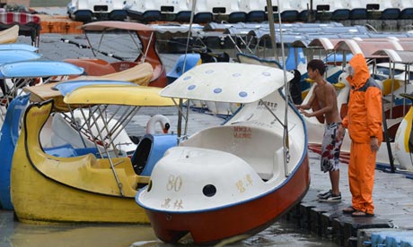
Workers remove tourist boats in the south-east Philippines as typhoon Usagi approaches. Photograph: Sam Yeh/AFP/Getty Images
 
 
The Philippines has evacuated northern coastal villages, suspended ferry services and called in fishing boats as an approaching category 5 storm, already labelled a super-typhoon, gained strength on a path set for southern China.
With winds of 127 mph, typhoon Usagi, the strongest storm to hit the western Pacific this year, was moving north-west between the Philippines and Taiwan and headed for Hong Kong and south China.
China's Xinhua news agency said preparations were being made for an "emergency response" in southern coastal areas.
Storm alerts have been raised on the rice and coconut-growing island of Batanes and 15 provinces on the main Philippines island of Luzon, the weather bureau said.
"Our people there know the drill, but we have also issued warnings to take safety precautions," the budget secretary, Florencio Abad, said. "We're praying it doesn't create death and destruction."
A typhoon hit Batanes in 1987, destroying all roads as the water level surged as high as seven metres. "All our coconut trees broke in half," Abad said.
Power and communications in the area have been cut off for safety reasons and hospitals were put on alert as disaster agencies stocked up on food and water. Troops were also put on standby.


Read More Here


******************************************************************************

Monstrous super typhoon Usagi holding its own, Hong Kong braces for possible impact

This image was taken by the Japan Meteorological Agency's MTSAT-2 satellite at 0730Z on September 20, 2013. (NOAA)
This image was taken by the Japan Meteorological Agency’s MTSAT-2 satellite at 0730Z on September 20, 2013. (NOAA)


Super typhoon Usagi, 2013′s strongest storm on the planet, may have peaked in intensity, but remains an extremely dangerous cyclone as it continues on a collision course with southern Taiwan and, likely, Hong Kong.

The Joint Typhoon Warning Center says Osagi’s maximum sustained winds are 150 mph, the equivalent of a category 4 hurricane.  That’s down from at least 160 mph Thursday (category 5 level). But this is a mammoth storm, tropical storm force winds span 275 miles across it.
On Thursday evening, a satellite-based estimate of its minimum pressure was an astonishingly low 882 mb, which would have made it the deepest and most intense storm to exist on Earth since 1984 (tied with hurricane Wilma in 2005).

Look at this incredible high resolution satellite image of the storm from Thursday afternoon, revealing the textbook traits of a flawless cyclone:


(Colorado State University)


Usagi infrared satellite view 12:33 p.m. ET Thursday (Colorado State University)
You see the cloud-free, distinct eye which is surrounded by tall thunderstorms on all sides.
Due to a re-arrangement of its internal structure since that time, known as an eye-wall replacement cycle, Usagi has lost some steam and its satellite presentation – while impressive – is less than perfect.


(NOAA)


Usagi infrared satellite view 1:14 p.m. ET Friday (NOAA)


Its eye is somewhat ragged, and deep convection (a fancy term for thunderstorms) is less pronounced in its northeast quadrant.
What’s next for Usagi?
The Joint Typhoon Warning Center predicts additional weakening as Usagi’s circulation is disrupted by Taiwan. Usagi will batter Taiwan’s south and east coast with damaging winds, torrential range, massive waves, and a dangerous storm surge today into Saturday. The storm’s rain bands have already begun to lash coastal areas.

Link: Animated Taiwan radar loop

Usagi is then expected to cross the South China Sea, but further weakening is forecast.
“THE SYSTEM IS UNLIKELY TO RE-INTENSIFY OVER THE SOUTH CHINA SEA DUE TO LAND INTERACTION AND DECREASING OCEAN HEAT CONTENT,” says the Joint Typhoon Warning Center.


Read More Here


******************************************************************************
Enhanced by Zemanta