Friday, August 2, 2013

Forest / Wild Fire - State of Washington, [Kittitas County]

Earth Watch Report  -  Forest/Wild Fires

Colockum Tarps Fire
...
 01.08.2013Forest / Wild FireUSAState of Washington, [Kittitas County]Damage level Details
...

Forest / Wild Fire in USA on Thursday, 01 August, 2013 at 03:16 (03:16 AM) UTC.

Description
Authorities in central Washington ordered a new round of evacuations Wednesday near a surging wildfire, as firefighters worked to better control the blaze before thunderstorms swept through the region. The fire danger was expected to remain high in Eastern Washington through Thursday amid the threat of lightning strikes from thunderstorms and gusty winds. The Colockum Tarps Fire south of Wenatchee was burning across 93 square miles of grass, sagebrush and timber in Chelan and Kittitas counties, and winds from the east were pushing the blaze into timber to the west. The Kittitas County Sheriff's Office ordered residents of about 75 homes and cabins to evacuate Wednesday, and several recreation areas were closed, fire officials said. In addition, a horse and Bible camp with 40 horses and eight children was evacuated, the Ellensburg Daily Record reported. The fire was about a half mile from the Wild Horse Wind Farm, which was closed to the public. About 370 firefighters were working to control the blaze, which was 8 percent contained, fire officials said.
...

Dozens of homes ordered evacuated as wildfires surge


Dozens of homes ordered evacuated as wildfires surge »Play Video
WENATCHEE, Wash. (AP) - A wildfire that has burned across 104 square miles of grass, sagebrush and timber in two central Washington counties churned to the southwest Wednesday, burning to the edge of a wind farm and forcing authorities to order a new round of evacuations.
Firefighters already faced extreme fire behavior, with dry fuels and high temperatures, and were on watch for gusty winds and the threat of lightning strikes from thunderstorms expected through Thursday.
The Kittitas County Sheriff's Office ordered residents of about 75 scattered homes and cabins to evacuate, and several recreation areas were closed.
The fast-moving Colockum Tarps Fire, which originated south of Wenatchee, burned to the north end of the Wild Horse Wind Farm, about 17 miles east of Ellensburg overlooking the Columbia River.


Read More Here


...
Enhanced by Zemanta

Flood - Myanmar (Burma), State of Karen, [Karen-wide]

Earth Watch Report  -  Flooding

  • Image Credit: EPA
  • A picture made available on 31 July 2013 shows a car submerged on a street outside an apartment building at a residential area in the Thai-Myanmar border district of Mae Sot, Tak province, northern Thailand, 30 July 2013.
...
 01.08.2013FloodMyanmar (Burma)State of Karen, [Karen-wide]Damage level
 
Details
...

Flood in Myanmar (Burma) on Wednesday, 31 July, 2013 at 13:52 (01:52 PM) UTC.

Description
Nearly 25,000 people have been evacuated to makeshift camps after floods ravaged eastern Myanmar, an official said Wednesday, as relief teams struggled to reach remote areas inundated by water. Flood waters have risen dramatically after several days of heavy rain in Karen State forcing thousands to flee to nearly 80 relief camps, Chum Hre, director of the social welfare, relief and resettlement department said. "Altogether 24,499 flood victims have been evacuated" in Karen State, he said, adding hundreds more had been displaced in Mon and Rakhine states. "It is very difficult to reach some of the disaster-hit places because of the bad weather and landslides," he said, adding that helicopters had been deployed.
...

Flood in Myanmar (Burma) on Wednesday, 31 July, 2013 at 13:52 (01:52 PM) UTC.

Back
Updated:Thursday, 01 August, 2013 at 03:42 UTC
Description
Nearly 25,000 people have been evacuated to makeshift camps after floods ravaged eastern Myanmar, an official said yesterday, as relief teams struggled to reach remote areas inundated by water. Floodwaters have risen dramatically after several days of heavy rain in Karen State, forcing thousands to flee to nearly 80 relief camps, Chum Hre, director of the social welfare, relief and resettlement department said. "Altogether 24,499 flood victims have been evacuated" in Karen State, he said, adding hundreds more had been displaced in Mon and Rakhine states. “It is very difficult to reach some of the disaster-hit places because of the bad weather and landslides,” he said, adding that helicopters had been deployed. Heavy rains also inundated areas across the border in Thailand. Seven Thai provinces remained flooded yesterday, the Interior Ministry said in its daily update. Three people have died since Monday after they were hit by trees felled by fast-moving water, it added. In Thailand’s western town of Mae Sot, which borders the flood-hit area of Myanmar, waters have receded in the town centre but remain high in outlying areas, especially near the frontier checkpoint. The situation has returned to normal in Mae Sot city,” Pramote Chantasri, of Mae Sot City Municipality said. “The worst was on Monday after four days of heavy rain in the mountains,” he said, adding the bridge between the two countries remains open. Parts of Thailand and Myanmar are inundated each year during the monsoon period, which ends in October. Deadly floods in 2011 left more than 800 dead in Thailand, inundating swathes of the country for months, deluging parts of the capital and taking a heavy toll on the country’s lucrative manufacturing industry.
...

Myanmar floods force 25,000 into relief camps

Flood waters have risen dramatically after several days of heavy rain
  • AFP
  • Published: 13:19 July 31, 2013
  • Gulf News
Yangon, Yangon division: Nearly 25,000 people have been evacuated to makeshift camps after floods ravaged eastern Myanmar, an official said on Wednesday, as relief teams struggled to reach remote areas inundated by water.
Flood waters have risen dramatically after several days of heavy rain in Karen State forcing thousands to flee to nearly 80 relief camps, Chum Hre, director of the social welfare, relief and resettlement department said.
“Altogether 24,499 flood victims have been evacuated” in Karen State, he said, adding hundreds more had been displaced in Mon and Rakhine states.
“It is very difficult to reach some of the disaster-hit places because of the bad weather and landslides,” he said, adding that helicopters had been deployed.
Heavy rains also inundated areas across the border in Thailand.
Seven Thai provinces remained flooded on Wednesday, the Interior Ministry said in its daily update.
Three people have died since Monday after they were hit by trees felled by fast-moving water, it added.


Read More Here


...
Enhanced by Zemanta

Biological Hazard - Canada, Province of British Columbia, Victoria [Selkirk Place Care Facility] : Norovirus (fatal)

Earth Watch Report   -  Biological Hazards

9 people infected with the Norovirus have died this month at a health care facility in Victoria 

Norovirus linked to 9 deaths2:39

....
01.08.2013Biological HazardCanadaProvince of British Columbia, Victoria [Selkirk Place Care Facility]Damage levelDetails
....

Biological Hazard in Canada on Wednesday, 31 July, 2013 at 04:54 (04:54 AM) UTC.

Description
A serious outbreak of norovirus may have caused the deaths of nine people at the Selkirk Place Care Facility in Victoria this month. The Vancouver Island Health Authority said although the cause of death in each case has not been determined, it believes the flu-like virus likely contributed. VIHA confirmed 100 patients, half the population at the facility, are sick, with three having to be hospitalized since July 11. Norovirus - once known as Norwalk virus �" is highly contagious and often spreads in places like schools, cruise ships and nursing homes, especially during the winter. Sometimes mistakenly called stomach flu, the virus causes bouts of vomiting and diarrhea for a few days. A new strain of the virus evolves every two or three years; the latest was identified earlier this year and is known as the Sydney strain. There are no drugs for the treatment of norovirus itself, although it is important to drink lots of fluids to guard against dehydration. This latest outbreak comes just two months after 29 people on a cruise ship heading for Vancouver came down with the virus.
Biohazard name:Norovirus (fatal)
Biohazard level:2/4 Medium
Biohazard desc.:Bacteria and viruses that cause only mild disease to humans, or are difficult to contract via aerosol in a lab setting, such as hepatitis A, B, and C, influenza A, Lyme disease, salmonella, mumps, measles, scrapie, dengue fever, and HIV. "Routine diagnostic work with clinical specimens can be done safely at Biosafety Level 2, using Biosafety Level 2 practices and procedures. Research work (including co-cultivation, virus replication studies, or manipulations involving concentrated virus) can be done in a BSL-2 (P2) facility, using BSL-3 practices and procedures. Virus production activities, including virus concentrations, require a BSL-3 (P3) facility and use of BSL-3 practices and procedures", see Recommended Biosafety Levels for Infectious Agents.
Symptoms:
Status:confirmed
...


Biological Hazard in Canada on Wednesday, 31 July, 2013 at 04:54 (04:54 AM) UTC.

Back
Updated: Thursday, 01 August, 2013 at 07:14 UTC
Description
A fast-spreading norovirus outbreak that sickened more than 150 and could be linked to nine deaths may be coming to an end at a Victoria, B.C., seniors’ home, the Vancouver Island Health Authority said Wednesday. The virus infected 106 residents and 53 staff members at Selkirk Place since the outbreak began July 11. While nine people have also died since then, and norovirus may have been a contributing factor, the health authority said the causes of deaths still have to be determined. “The residents are generally quite elderly and frail and have multiple health conditions,” spokeswoman Sarah Plank said in a phone interview. “So they’re certainly at risk from it, but generally people don’t die of norovirus, but rather with norovirus.” Norovirus is part of a group of viruses that causes severe vomiting and diarrhea. Most people are able to recover after a few days, but for elderly people with chronic illnesses, the highly contagious virus is something their bodies can ill-afford, said chief medical officer Dr. Richard Stanwick. “What you have is a virus that would give you and I some grief for maybe three days, but for somebody who is struggling with sometimes 10 to 11 medical conditions, this is really just one more thing the body just can’t handle,” he said.

“Unfortunately what happens is the norovirus creates a stressor and pushes people over into heart failure or other conditions that will ultimately claim their life.” While norovirus is common in the summertime and in long-term care homes, Plank said the outbreak at Selkirk Place was unusually wide-spreading. Forty people became ill within 24 hours of the first case, she said. “Usually if it’s just one or two cases, you can confine it, you isolate the patients and you keep them to their own floor so you can contain the outbreak to just one floor or one unit,” she said. “But in this one, because there was such a large number of people who became ill so quickly, it spread to more people than we would normally see.” Stanwick said the norovirus that swept through Selkirk Place was likely “the garden variety,” and not a new, nastier strain that was detected in Australia and the U.S. last year. However, the fact that so many people became ill so rapidly is concerning, and suggests the virus came from a common source, he said. “From time to time, we do eventually discover that somebody had a sick child who came in, who was just feeling a little off,” he said. “It doesn’t always present as this violent illness, but it’s enough that they can actually shed the virus and unknowingly pass it on because they’re so mildly ill, they didn’t realize they had a norovirus infection.” Stanwick said the health authority will be investigating who at the Victoria care home may have been sick prior to the outbreak, as well as whether anyone who may have had the virus was handling the facility’s food. Plank said staff at Selkirk Place did everything they could to control the outbreak, including isolating sick residents in their rooms, doing additional cleaning, restricting visitors, rescheduling hospital visits, and allowing only healthy residents to dine in common areas. Eleven people remain ill at the care home, but Plank said she believes the outbreak has peaked, and the worst is over. Still, Stanwick warns that norovirus is still circulating in the community, causing at least one summer camp on Vancouver Island to send children home after an outbreak.
...

Norovirus linked to 9 deaths in B.C. care home

Virus is highly contagious and causes vomiting and diarrhea

Posted: Jul 30, 2013 6:35 PM PT

Last Updated: Jul 31, 2013 3:41 PM PT

Video Content

9 people infected with the Norovirus have died this month at a health care facility in Victoria 
Norovirus linked to 9 deaths2:39

An outbreak of norovirus has been linked to the deaths of nine people at the Selkirk Place care facility in Victoria this month.
The Vancouver Island Health Authority said although the cause of death in each case has not been determined, it believes the gastrointestinal virus likely contributed.
VIHA confirmed 100 patients, half the population at the facility, are sick, with three having to be hospitalized since July 11.
Norovirus — once known as Norwalk virus — is highly contagious and often spreads in places like schools, cruise ships and nursing homes, especially during the winter.
The stomach bug causes bouts of vomiting and diarrhea which can last for a few days.
Read More Here
...
Enhanced by Zemanta

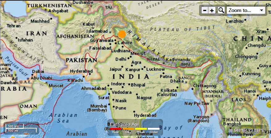
India - 5.4 - 13km SE of Kishtwar

Earth Watch Report  -  Earthquakes

 photo India-54MagEQAugust1st2013_zps500ce01d.jpg
...

M5.4 - 13km SE of Kishtwar, India

 2013-08-02 02:32:48 UTC

Earthquake location 33.233°N, 75.876°E

Event Time

  1. 2013-08-02 02:32:48 UTC
  2. 2013-08-02 08:02:48 UTC+05:30 at epicenter
  3. 2013-08-01 21:32:48 UTC-05:00 system time

Location

33.233°N 75.876°E depth=15.8km (9.8mi)

Nearby Cities

  1. 13km (8mi) SE of Kishtwar, India
  2. 30km (19mi) ENE of Doda, India
  3. 31km (19mi) NNE of Bhadarwah, India
  4. 76km (47mi) ENE of Udhampur, India
  5. 268km (167mi) E of Islamabad, Pakistan
....

Tectonic Summary

Seismotectonics of the Himalaya and Vicinity

Seismicity in the Himalaya dominantly results from the continental collision of the India and Eurasia plates, which are converging at a relative rate of 40-50 mm/yr. Northward underthrusting of India beneath Eurasia generates numerous earthquakes and consequently makes this area one of the most seismically hazardous regions on Earth. The surface expression of the plate boundary is marked by the foothills of the north-south trending Sulaiman Range in the west, the Indo-Burmese Arc in the east and the east-west trending Himalaya Front in the north of India.
The India-Eurasia plate boundary is a diffuse boundary, which in the region near the north of India, lies within the limits of the Indus-Tsangpo (also called the Yarlung-Zangbo) Suture to the north and the Main Frontal Thrust to the south. The Indus-Tsangpo Suture Zone is located roughly 200 km north of the Himalaya Front and is defined by an exposed ophiolite chain along its southern margin. The narrow (<200km) Himalaya Front includes numerous east-west trending, parallel structures. This region has the highest rates of seismicity and largest earthquakes in the Himalaya region, caused mainly by movement on thrust faults. Examples of significant earthquakes, in this densely populated region, caused by reverse slip movement include the 1934 M8.1 Bihar, the 1905 M7.5 Kangra and the 2005 M7.6 Kashmir earthquakes. The latter two resulted in the highest death tolls for Himalaya earthquakes seen to date, together killing over 100,000 people and leaving millions homeless. The largest instrumentally recorded Himalaya earthquake occurred on 15th August 1950 in Assam, eastern India. This M8.6 right-lateral, strike-slip, earthquake was widely felt over a broad area of central Asia, causing extensive damage to villages in the epicentral region.
The Tibetan Plateau is situated north of the Himalaya, stretching approximately 1000km north-south and 2500km east-west, and is geologically and tectonically complex with several sutures which are hundreds of kilometer-long and generally trend east-west. The Tibetan Plateau is cut by a number of large (>1000km) east-west trending, left-lateral, strike-slip faults, including the long Kunlun, Haiyuan, and the Altyn Tagh. Right-lateral, strike-slip faults (comparable in size to the left-lateral faults), in this region include the Karakorum, Red River, and Sagaing. Secondary north-south trending normal faults also cut the Tibetan Plateau. Thrust faults are found towards the north and south of the Tibetan Plateau. Collectively, these faults accommodate crustal shortening associated with the ongoing collision of the India and Eurasia plates, with thrust faults accommodating north south compression, and normal and strike-slip accommodating east-west extension.
Along the western margin of the Tibetan Plateau, in the vicinity of south-eastern Afghanistan and western Pakistan, the India plate translates obliquely relative to the Eurasia plate, resulting in a complex fold-and-thrust belt known as the Sulaiman Range. Faulting in this region includes strike-slip, reverse-slip and oblique-slip motion and often results in shallow, destructive earthquakes. The active, left-lateral, strike-slip Chaman fault is the fastest moving fault in the region. In 1505, a segment of the Chaman fault near Kabul, Afghanistan, ruptured causing widespread destruction. In the same region the more recent 30 May 1935, M7.6 Quetta earthquake, which occurred in the Sulaiman Range in Pakistan, killed between 30,000 and 60,000 people.
On the north-western side of the Tibetan Plateau, beneath the Pamir-Hindu Kush Mountains of northern Afghanistan, earthquakes occur at depths as great as 200 km as a result of remnant lithospheric subduction. The curved arc of deep earthquakes found in the Hindu Kush Pamir region indicates the presence of a lithospheric body at depth, thought to be remnants of a subducting slab. Cross-sections through the Hindu Kush region suggest a near vertical northerly-dipping subducting slab, whereas cross-sections through the nearby Pamir region to the east indicate a much shallower dipping, southerly subducting slab. Some models suggest the presence of two subduction zones; with the Indian plate being subducted beneath the Hindu Kush region and the Eurasian plate being subducted beneath the Pamir region. However, other models suggest that just one of the two plates is being subducted and that the slab has become contorted and overturned in places.
Shallow crustal earthquakes also occur in this region near the Main Pamir Thrust and other active Quaternary faults. The Main Pamir Thrust, north of the Pamir Mountains, is an active shortening structure. The northern portion of the Main Pamir Thrust produces many shallow earthquakes, whereas its western and eastern borders display a combination of thrust and strike-slip mechanisms. On the 18 February 1911, the M7.4 Sarez earthquake ruptured in the Central Pamir Mountains, killing numerous people and triggering a landside, which blocked the Murghab River.
Further north, the Tian Shan is a seismically active intra-continental mountain belt, which extends 2500 km in an ENE-WNW orientation north of the Tarim Basin. This belt is defined by numerous east-west trending thrust faults, creating a compressional basin and range landscape. It is generally thought that regional stresses associated with the collision of the India and Eurasia plates are responsible for faulting in the region. The region has had three major earthquakes (>M7.6) at the start of the 20th Century, including the 1902 Atushi earthquake, which killed an estimated 5,000 people. The range is cut through in the west by the 700-km-long, northwest-southeast striking, Talas-Ferghana active right-lateral, strike-slip fault system. Though the system has produced no major earthquakes in the last 250 years, paleo-seismic studies indicate that it has the potential to produce M7.0+ earthquakes and it is thought to represent a significant hazard.
The northern portion of the Tibetan Plateau itself is largely dominated by the motion on three large left-lateral, strike-slip fault systems; the Altyn Tagh, Kunlun and Haiyuan. The Altyn Tagh fault is the longest of these strike slip faults and it is thought to accommodate a significant portion of plate convergence. However, this system has not experienced significant historical earthquakes, though paleoseismic studies show evidence of prehistoric M7.0-8.0 events. Thrust faults link with the Altyn Tagh at its eastern and western termini. The Kunlun Fault, south of the Altyn Tagh, is seismically active, producing large earthquakes such as the 8th November 1997, M7.6 Manyi earthquake and the 14th November 2001, M7.8 Kokoxili earthquake. The Haiyuan Fault, in the far north-east, generated the 16 December 1920, M7.8 earthquake that killed approximately 200,000 people and the 22 May 1927 M7.6 earthquake that killed 40,912.
The Longmen Shan thrust belt, along the eastern margin of the Tibetan Plateau, is an important structural feature and forms a transitional zone between the complexly deformed Songpan-Garze Fold Belt and the relatively undeformed Sichuan Basin. On 12 May 2008, the thrust belt produced the reverse slip, M7.9 Wenchuan earthquake, killing over 87,000 people and causing billions of US dollars in damages and landslides which dammed several rivers and lakes.
Southeast of the Tibetan Plateau are the right-lateral, strike-slip Red River and the left-lateral, strike-slip Xiangshuihe-Xiaojiang fault systems. The Red River Fault experienced large scale, left-lateral ductile shear during the Tertiary period before changing to its present day right-lateral slip rate of approximately 5 mm/yr. This fault has produced several earthquakes >M6.0 including the 4 January 1970, M7.5 earthquake in Tonghai which killed over 10,000 people. Since the start of the 20th century, the Xiangshuihe-Xiaojiang Fault system has generated several M7.0+ earthquakes including the M7.5 Luhuo earthquake which ruptured on the 22 April 1973. Some studies suggest that due to the high slip rate on this fault, future large earthquakes are highly possible along the 65km stretch between Daofu and Qianning and the 135km stretch that runs through Kangding.
Shallow earthquakes within the Indo-Burmese Arc, predominantly occur on a combination of strike-slip and reverse faults, including the Sagaing, Kabaw and Dauki faults. Between 1930 and 1956, six M7.0+ earthquakes occurred near the right-lateral Sagaing Fault, resulting in severe damage in Myanmar including the generation of landslides, liquefaction and the loss of 610 lives. Deep earthquakes (200km) have also been known to occur in this region, these are thought to be due to the subduction of the eastwards dipping, India plate, though whether subduction is currently active is debated. Within the pre-instrumental period, the large Shillong earthquake occurred on the 12 June 1897, causing widespread destruction.
....

Thursday, August 1, 2013

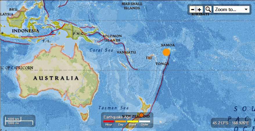
Tinga - 5.8 Magnitude Earthquake - 80km NNE of Hihifo

Earth Watch Report  -  Earthquakes


 photo Tonga-58MagEQAugust1st2013_zps537bc49b.jpg
....

M5.8 - 80km NNE of Hihifo, Tonga

 2013-08-01 20:01:41 UTC

Earthquake location 15.282°S, 173.444°W

Event Time

  1. 2013-08-01 20:01:41 UTC
  2. 2013-08-01 08:01:41 UTC-12:00 at epicenter
  3. 2013-08-01 15:01:41 UTC-05:00 system time

Location

15.282°S 173.444°W depth=17.0km (10.6mi)

Nearby Cities

  1. 80km (50mi) NNE of Hihifo, Tonga
  2. 241km (150mi) SW of Apia, Samoa
  3. 311km (193mi) WSW of Tafuna, American Samoa
  4. 315km (196mi) WSW of Pago Pago, American Samoa
  5. 673km (418mi) NNE of Nuku`alofa, Tonga
...

Tectonic Summary

Seismotectonics of the Eastern Margin of the Australia Plate

The eastern margin of the Australia plate is one of the most sesimically active areas of the world due to high rates of convergence between the Australia and Pacific plates. In the region of New Zealand, the 3000 km long Australia-Pacific plate boundary extends from south of Macquarie Island to the southern Kermadec Island chain. It includes an oceanic transform (the Macquarie Ridge), two oppositely verging subduction zones (Puysegur and Hikurangi), and a transpressive continental transform, the Alpine Fault through South Island, New Zealand.
Since 1900 there have been 15 M7.5+ earthquakes recorded near New Zealand. Nine of these, and the four largest, occurred along or near the Macquarie Ridge, including the 1989 M8.2 event on the ridge itself, and the 2004 M8.1 event 200 km to the west of the plate boundary, reflecting intraplate deformation. The largest recorded earthquake in New Zealand itself was the 1931 M7.8 Hawke's Bay earthquake, which killed 256 people. The last M7.5+ earthquake along the Alpine Fault was 170 years ago; studies of the faults' strain accumulation suggest that similar events are likely to occur again.
North of New Zealand, the Australia-Pacific boundary stretches east of Tonga and Fiji to 250 km south of Samoa. For 2,200 km the trench is approximately linear, and includes two segments where old (>120 Myr) Pacific oceanic lithosphere rapidly subducts westward (Kermadec and Tonga). At the northern end of the Tonga trench, the boundary curves sharply westward and changes along a 700 km-long segment from trench-normal subduction, to oblique subduction, to a left lateral transform-like structure.
Australia-Pacific convergence rates increase northward from 60 mm/yr at the southern Kermadec trench to 90 mm/yr at the northern Tonga trench; however, significant back arc extension (or equivalently, slab rollback) causes the consumption rate of subducting Pacific lithosphere to be much faster. The spreading rate in the Havre trough, west of the Kermadec trench, increases northward from 8 to 20 mm/yr. The southern tip of this spreading center is propagating into the North Island of New Zealand, rifting it apart. In the southern Lau Basin, west of the Tonga trench, the spreading rate increases northward from 60 to 90 mm/yr, and in the northern Lau Basin, multiple spreading centers result in an extension rate as high as 160 mm/yr. The overall subduction velocity of the Pacific plate is the vector sum of Australia-Pacific velocity and back arc spreading velocity: thus it increases northward along the Kermadec trench from 70 to 100 mm/yr, and along the Tonga trench from 150 to 240 mm/yr.
The Kermadec-Tonga subduction zone generates many large earthquakes on the interface between the descending Pacific and overriding Australia plates, within the two plates themselves and, less frequently, near the outer rise of the Pacific plate east of the trench. Since 1900, 40 M7.5+ earthquakes have been recorded, mostly north of 30°S. However, it is unclear whether any of the few historic M8+ events that have occurred close to the plate boundary were underthrusting events on the plate interface, or were intraplate earthquakes. On September 29, 2009, one of the largest normal fault (outer rise) earthquakes ever recorded (M8.1) occurred south of Samoa, 40 km east of the Tonga trench, generating a tsunami that killed at least 180 people.
Across the North Fiji Basin and to the west of the Vanuatu Islands, the Australia plate again subducts eastwards beneath the Pacific, at the North New Hebrides trench. At the southern end of this trench, east of the Loyalty Islands, the plate boundary curves east into an oceanic transform-like structure analogous to the one north of Tonga.
Australia-Pacific convergence rates increase northward from 80 to 90 mm/yr along the North New Hebrides trench, but the Australia plate consumption rate is increased by extension in the back arc and in the North Fiji Basin. Back arc spreading occurs at a rate of 50 mm/yr along most of the subduction zone, except near ~15°S, where the D'Entrecasteaux ridge intersects the trench and causes localized compression of 50 mm/yr in the back arc. Therefore, the Australia plate subduction velocity ranges from 120 mm/yr at the southern end of the North New Hebrides trench, to 40 mm/yr at the D'Entrecasteaux ridge-trench intersection, to 170 mm/yr at the northern end of the trench.
Large earthquakes are common along the North New Hebrides trench and have mechanisms associated with subduction tectonics, though occasional strike slip earthquakes occur near the subduction of the D'Entrecasteaux ridge. Within the subduction zone 34 M7.5+ earthquakes have been recorded since 1900. On October 7, 2009, a large interplate thrust fault earthquake (M7.6) in the northern North New Hebrides subduction zone was followed 15 minutes later by an even larger interplate event (M7.8) 60 km to the north. It is likely that the first event triggered the second of the so-called earthquake "doublet".
More information on regional seismicity and tectonics
...

Instrumental Intensity

ShakeMap Intensity Image
...
Enhanced by Zemanta

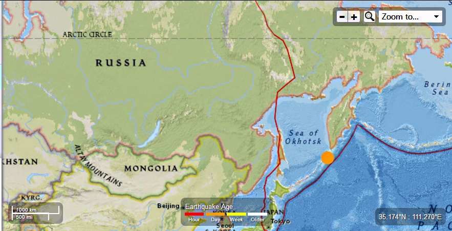
Russia - 5.1 Magnitude Earthquake - 120km S of Severo-Kuril'sk

Earth watch Report  -  Earthquakes


 photo Russia-51MagEQAugust1st2013_zpsac50bc75.jpg
...

M5.1 - 120km S of Severo-Kuril'sk, Russia

 2013-08-01 16:39:59 UTC

Earthquake location 49.592°N, 156.111°E

Event Time

  1. 2013-08-01 16:39:59 UTC
  2. 2013-08-02 02:39:59 UTC+10:00 at epicenter
  3. 2013-08-01 11:39:59 UTC-05:00 system time

Location

49.592°N 156.111°E depth=56.5km (35.1mi)

Nearby Cities

  1. 120km (75mi) S of Severo-Kuril'sk, Russia
  2. 404km (251mi) SSW of Vilyuchinsk, Russia
  3. 422km (262mi) SSW of Petropavlovsk-Kamchatskiy, Russia
  4. 429km (267mi) SSW of Yelizovo, Russia
  5. 2039km (1267mi) NE of Tokyo, Japan
...

Tectonic Summary

Seismotectonics of the Kuril-Kamchatka Arc

The Kuril-Kamchatka arc extends approximately 2,100 km from Hokkaido, Japan, along the Kuril Islands and the Pacific coast of the Kamchatka Peninsula to its intersection with the Aleutian arc near the Commander Islands, Russia. It marks the region where the Pacific plate subducts into the mantle beneath the Okhotsk microplate, part of the larger North America plate. This subduction is responsible for the generation of the Kuril Islands chain, active volcanoes located along the entire arc, and the deep offshore Kuril-Kamchatka trench. Relative to a fixed North America plate, the Pacific plate is moving towards the northwest at a rate that increases from 75 mm/year near the northern end of the arc to 83 mm/year in the south.
Plate motion is predominantly convergent along the Kuril-Kamchatka arc with obliquity increasing towards the southern section of the arc. The subducting Pacific plate is relatively old, particularly adjacent to Kamchatka where its age is greater than 100 Ma. Consequently, the Wadati-Benioff zone is well defined to depths of approximately 650 km. The central section of the arc is comprised of an oceanic island arc system, which differs from the continental arc systems of the northern and southern sections. Oblique convergence in the southern Kuril arc results in the partitioning of stresses into both trench-normal thrust earthquakes and trench-parallel strike-slip earthquakes, and the westward translation of the Kuril forearc. This westward migration of the Kuril forearc currently results in collision between the Kuril arc in the north and the Japan arc in the south, resulting in the deformation and uplift of the Hidaka Mountains in central Hokkaido.
The Kuril-Kamchatka arc is considered one of the most seismically active regions in the world. Deformation of the overriding North America plate generates shallow crustal earthquakes, whereas slip at the subduction zone interface between the Pacific and North America plates generates interplate earthquakes that extend from near the base of the trench to depths of 40 to 60 km. At greater depths, Kuril-Kamchatka arc earthquakes occur within the subducting Pacific plate and can reach depths of approximately 650 km.
This region has frequently experienced large (M>7) earthquakes over the past century. Since 1900, seven great earthquakes (M8.3 or larger) have also occurred along the arc, with mechanisms that include interplate thrust faulting, and intraplate faulting. Damaging tsunamis followed several of the large interplate megathrust earthquakes. These events include the February 3, 1923 M8.4 Kamchatka, the November 6,1958 M8.4 Etorofu, and the September 25, 2003 M8.3 Hokkaido earthquakes. A large M8.5 megathrust earthquake occurred on October 13, 1963 off the coast of Urup, an island along the southern Kuril arc, which generated a large tsunami in the Pacific Ocean and the Sea of Okhotsk, and caused run-up wave heights of up to 4-5 m along the Kuril arc. The largest megathrust earthquake to occur along the entire Kurile-Kamchatka arc in the 20th century was the November 4, 1952 M9.0 event. This earthquake was followed by a devastating tsunami with run-up wave heights as high as 12 m along the coast of Paramushir, a small island immediately south of Kamchatka, causing significant damage to the city of Severo-Kurilsk.
On October 4,1994, a large (M8.3) intraplate event occurred within the subducted oceanic lithosphere off the coast of Shikotan Island causing intense ground shaking, landslides, and a tsunami with run-up heights of up to 10 m on the island.
The most recent megathrust earthquake in the region was the November 15, 2006 M8.3 Kuril Island event, located in the central section of the arc. Prior to this rupture, this part of the subduction zone had been recognized as a seismic gap spanning from the northeastern end of the 1963 rupture zone to the southwestern end of the 1952 rupture. Two months after the 2006 event, a great (M8.1) normal faulting earthquake occurred on January 13, 2007 in the adjacent outer rise region of the Pacific plate. It has been suggested that the 2007 event may have been caused by the stresses generated from the 2006 earthquake.

More information on regional seismicity and tectonics
...
...
...
Enhanced by Zemanta