Wednesday, November 4, 2015

One Of The Most Dangerous Volcanoes In North America Is Roaring To Life


End Of The American Dream

The American Dream Is Becoming A Nightmare And Life As We Know It Is About To Change
Popocatepetl - from Wikipedia

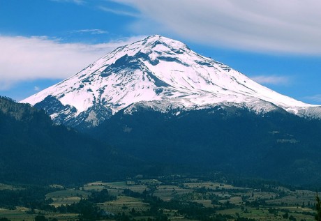
More than 25 million people live in the vicinity of North America’s 2nd-highest volcano, and in recent weeks this volcano has been steadily rumbling and has been spewing out massive amounts of black smoke and ash.  I have previously written about “the most dangerous mountain in the United States” (Mt. Rainier), but if the volcano that I am talking about today experiences a full-blown explosive eruption it could potentially be a cataclysmic event beyond what most of us would dare to imagine.  Popocatepetl is an Aztec word that means “smoking mountain”, and it is also the name of a giant volcano that sits approximately 50 miles away from Mexico City’s 18 million residents. 

“Popo”, as it is called by locals, was dormant for much of the 20th century, but it came back to life in 1994.  And now all of this unusual activity in recent weeks has many wondering if a major eruption may be imminent.

Historians tell us that Popocatepetl had a dramatic impact on the ancient Aztecs.  Giant mud flows produced by massive eruptions covered entire Aztec cities.  In fact, some of these mud flows were so large that they buried entire pyramids in super-heated mud.

But we haven’t witnessed anything like that in any of our lifetimes, so it is hard to even imagine devastation of that magnitude.

In addition to Mexico City’s mammoth population, there are millions of others that live in the surrounding region.  Overall, there are about 25 million people that live in the immediate vicinity of Popocatepetl.  Thankfully, we haven’t seen a major eruption of the volcano in modern times, but at some point that will change.

As most of you already know, Mexico sits on the “Ring of Fire” that stretches along the outer rim of the Pacific Ocean.  Over the past couple of years seismic activity throughout this area has started to really heat up, and according to Volcano Discovery there are dozens of volcanoes associated with the Ring of Fire that have recently erupted.


Read More Here

Tuesday, November 3, 2015

Earth approaching objects - November 3rd, 2015

]


Image Source  NASA
..........


All Sky Fireball Network

By Dr. Tony Phillips.


Every night, a network of NASA all-sky cameras scans the skies above the United States for meteoritic fireballs. Automated software maintained by NASA's Meteoroid Environment Office calculates their orbits, velocity, penetration depth in Earth's atmosphere and many other characteristics. Daily results are presented here on Spaceweather.com.
On Nov. 2, 2015, the network reported 37 fireballs.
(22 sporadics, 14 Northern Taurids, 1 Orionid)


In this diagram of the inner solar system, all of the fireball orbits intersect at a single point--Earth. The orbits are color-coded by velocity, from slow (red) to fast (blue). [Larger image] [movies]

Near Earth Asteroids
Potentially Hazardous Asteroids (PHAs) are space rocks larger than approximately 100m that can come closer to Earth than 0.05 AU. None of the known PHAs is on a collision course with our planet, although astronomers are finding new ones all the time.
..........
  Earth approaching objects (objects that are known in the next 30 days)
Object NameApporach DateLeftAU DistanceLD DistanceEstimated Diameter*Relative Velocity
(2010 UJ7)02nd November 20150 day(s)0.158261.622 m - 49 m13.31 km/s47916 km/h
(2015 TG238)03rd November 20151 day(s)0.186572.676 m - 170 m12.02 km/s43272 km/h
(2015 TD179)03rd November 20151 day(s)0.027110.635 m - 78 m10.12 km/s36432 km/h
(2009 LD)05th November 20153 day(s)0.139754.415 m - 34 m9.49 km/s34164 km/h
(2002 XY38)05th November 20153 day(s)0.082832.270 m - 160 m8.85 km/s31860 km/h
(2015 TM143)06th November 20154 day(s)0.069026.851 m - 110 m6.37 km/s22932 km/h
(2015 TL143)06th November 20154 day(s)0.065725.670 m - 160 m8.57 km/s30852 km/h
(2008 VA15)06th November 20154 day(s)0.075029.251 m - 110 m5.47 km/s19692 km/h
(2008 WQ2)08th November 20156 day(s)0.067926.437 m - 82 m8.45 km/s30419.999999999996 km/h
(2012 HG8)08th November 20156 day(s)0.192474.9310 m - 680 m19.44 km/s69984 km/h
138852 (2000 WN10)10th November 20158 day(s)0.125949.0240 m - 540 m13.78 km/s49608 km/h
(2010 XC15)10th November 20158 day(s)0.150858.7140 m - 310 m12.75 km/s45900 km/h
(2005 UN)12th November 201510 day(s)0.155060.318 m - 39 m8.59 km/s30924 km/h
(2000 WP19)15th November 201513 day(s)0.058622.880 m - 180 m10.43 km/s37548 km/h
(2012 LA11)16th November 201514 day(s)0.067826.416 m - 36 m4.88 km/s17568 km/h
(2009 WN6)18th November 201516 day(s)0.108742.331 m - 68 m10.02 km/s36072 km/h
(2015 TO178)18th November 201516 day(s)0.091335.533 m - 75 m6.19 km/s22284 km/h
413577 (2005 UL5)19th November 201517 day(s)0.01535.9240 m - 540 m18.99 km/s68364 km/h
(2002 VV17)19th November 201517 day(s)0.158261.6270 m - 590 m10.26 km/s36936 km/h
(2005 UJ6)20th November 201518 day(s)0.158061.5130 m - 300 m17.60 km/s63360.00000000001 km/h
(2005 EW169)21st November 201519 day(s)0.094036.6400 m - 900 m8.90 km/s32040 km/h
(2015 RQ82)23rd November 201521 day(s)0.073928.797 m - 220 m8.24 km/s29664 km/h
(2011 YS62)23rd November 201521 day(s)0.091535.6310 m - 680 m14.10 km/s50760 km/h
(2009 WB105)24th November 201522 day(s)0.038515.058 m - 130 m18.88 km/s67968 km/h
(2010 YC1)26th November 201524 day(s)0.194875.8150 m - 330 m14.08 km/s50688 km/h
(2004 BG41)26th November 201524 day(s)0.077030.035 m - 78 m10.25 km/s36900 km/h
(2012 XA133)26th November 201524 day(s)0.113444.1180 m - 390 m26.99 km/s97164 km/h
(2011 HJ7)26th November 201524 day(s)0.089334.8100 m - 230 m13.57 km/s48852 km/h
(2015 LE21)27th November 201525 day(s)0.112643.831 m - 68 m3.71 km/s13356 km/h
163696 (2003 EB50)28th November 201526 day(s)0.125448.81.4 km - 3.1 km23.68 km/s85248 km/h
(2007 EA26)28th November 201526 day(s)0.111543.4210 m - 470 m8.19 km/s29484 km/h
(1999 VN6)29th November 201527 day(s)0.186572.6350 m - 780 m12.33 km/s44388 km/h
345722 (2007 BG29)30th November 201528 day(s)0.139054.1670 m - 1.5 km11.26 km/s40536 km/h
(2014 WM7)30th November 201528 day(s)0.079631.051 m - 110 m10.08 km/s36288 km/h
(2005 XT77)01st December 201529 day(s)0.167965.3180 m - 390 m9.70 km/s34920 km/h
1 AU = ~150 million kilometers,1 LD = Lunar Distance = ~384,000 kilometersSource: NASA-NEO
..........
Notes: LD means "Lunar Distance." 1 LD = 384,401 km, the distance between Earth and the Moon. 1 LD also equals 0.00256 AU. MAG is the visual magnitude of the asteroid on the date of closest approach.

Swedish photographer captures sprawling sunspot complex, finds a spaceship hiding among its dark cores


Sunspot AR2443 is so big, it is attracting the attention of astrophotographers around the world. Earlier today when Peter Rosén of Stockholm, Sweden, photographed the sprawling complex, he found a spaceship hiding among its dark cores. Seriously. Take a close look at the image below:


Can't find the spaceship? Click here and here. "It is the International Space Station," explains Rosén. "I caught it making a split-second transit of the giant sunspot."

Indeed, AR244 is huge. From end to end it measures almost 200,000 km. Many of the dark cores are as large as terrestrial continents--and a couple are as large as Earth itself. These dimensions make it an easy target for backyard solar telecopes.

Of greater interest is the sunspot's potential for explosive activity. The spotty complex has a 'beta-gamma' magnetic field that harbors energy for strong M-class solar flares. Any such explosions will be geoeffective as the sunspot turns squarely toward Earth in the days ahead.

Landslide in the Big Horn Mountains causes canyon-like gash 750 yards long and about 50 yards wide - and it could get even bigger


The gigantic 'crack in the earth' in Wyoming: Landslide in the Big Horn Mountains causes canyon-like gash  - and it could get even bigger

  • The opening is thought to be 750 yards long and about 50 yards wide
  • Experts believe it is a slow-moving landslide
  • Believed it could be caused by a spring underneath the area
  • Crack may get larger 'as long as there's room for it to move'
 
A gigantic 'crack in the earth' has opened over Wyoming.
The gigantic opening was spotted in the Big Horn Mountains in Wyoming this month.
Now, a geologist has suggested it is in fact a 'slow-moving landslide' - and warned it could get even bigger.


Gaping: A gigantic opening was spotted in the Big Horn Mountains in Wyoming this month. SNS Outfitter & Guides said 'Everyone here is calling it "the gash". It's a really incredible sight'

Gaping: A gigantic opening was spotted in the Big Horn Mountains in Wyoming this month. SNS Outfitter & Guides said 'Everyone here is calling it 'the gash'. It's a really incredible sight'

 
The Wyoming Geological Survey's Seth Wittke told GrindTV: 'Without getting out there and looking at it, I can't be positive, but from what I've seen on the Internet it looks like a slow-moving landslide.'


Growing pains? Wittke has said the crack may get larger 'as long as there's room for it to move it could keep moving'

Growing pains? Wittke has said the crack may get larger 'as long as there's room for it to move it could keep moving'

He told the website: 'A lot of landslides are caused by subsurface lubrication by ground moisture or water and things like that, or in this case, a spring.'

Wittke told GrindTV the crack may get larger 'as long as there's room for it to move it could keep moving.'

He explained to The Powell Tribune that 'A number of things trigger them, moisture in the subsurface which causes weakness in soil or geology, and any process that would weaken the bedrock or unstabilize it somehow.'


Read More Here

Monday, November 2, 2015

Forest / Wild Fire - Indonesia, Province of Central Java, [Mount Merapi]


Forest / Wild FireIndonesiaProvince of Central Java, [Mount Merapi]Damage levelDetails
..........
Description
About 200 climbers are trapped were reported trapped after forest fire in Selo District sector on Mount Merapi, Central Java. Tempo gathered information that fire first appeared around 9 am Sunday, November 1, on a cliff around Pos 1, then the fire began to spread but not close the climbing lane. Head of Disaster Management Operation Control Center (Pusdalops) of the Boyolali Regional Disaster Management Agency (BPBD) Kurniawan Fajar Prasetyo said together with a SAR team and local residents, they are trying to evacuate the climbers. "We are trying that all hikers can go down," he said Sunday. According to Kurniawan, about 300 climbers went off, most of them departed from the Barameru Post, Selo, on Friday last week. So far around 100 people have been evacuated. Kurniawan said, health condition of the climbers that were evacuated are well. Some of them immediately return to their homes, some of them are staying to wait for their friends who are still trapped. While evacuating climbers, officers are fighting fire around Post 1. Kurniawan said if fire is not immediately extinguished, it could expand and close the climbing lane. Cause and the extent of the fire is not immediately known.
..........

The Huffington Post

Indonesian Forest Fires Have Been Burning Since August

Posted: Updated:
INDONESIA FIRE
 
Millions of acres of pristine, irreplaceable and invaluable Indonesian forest has been reduced to smouldering blackened ash, as 100,000 fires rage through the island region.

The sheer size and scale of the fire crisis is difficult to properly comprehend. Some of these fires have been burning since August, torching forest eons old and blanketing Papua, Singapore, Kuala Lumpur and countless islands of Indonesia in thick grey hazy smoke.

The World Resources Institute reports a staggering 127,000 fires have been reported in the region in 2015, the majority sparking and taking off in recent months.

Pictures from NASA's Earth Observatory, show the extent of smoke from the fires -- these images were taken over Borneo.


borneo\
Smoke over Borneo

Earlier in October, Indonesia's Forestry Ministry reported 4.2 million acres of forest had been burnt out, a figure which is sure to have risen since first reported.

Carbon emissions from the fires, at their peak, surpassed emissions belched out by the entire United States of America. More than half a million people have reported respiratory problems.


Read More Here
..........

..........

..........

Extreme Weather - Australia, State of Victoria, [Statewide]


..........
Extreme WeatherAustraliaState of Victoria, [Statewide]Damage levelDetails
..........
Description
Storms along the New South Wales-Victorian border have brought down trees and damaged a number of houses near Strathmerton, the Victorian State Emergency Service (SES) has said. A storm in a line from Tocumwall to north of Seymour has brought down a number of trees south of Shepparton around Kialla and in communities around Cobram and Nathalia. The Bureau of Meteorology (BoM) also warned of a severe storm, possibly with large hail, damaging winds and heavy rain near Pakenham, east south-east of Melbourne. The bureau issued an updated severe weather warning for destructive winds, large hail and heavy rainfall for the north east, west and south Gippsland and parts of the central, east Gippsland, northern country and north central forecast districts. Locations affected may include Morwell, Traralgon, Sale, Moe, Bairnsdale and Maffra. "The humidity has been building all week. It's built even further in the last 24 hours," senior forecaster Richard Carlyon said. "[The bad weather] wasn't too widespread yesterday. "But it looks like today, being more unstable, more humid and also a low pressure trough moving through we do have more ingredients available today for a more widespread nature of severe storms." Monday is expected to be much cooler and less humid but, in a fairly unsettled week, the pick of the days is Melbourne Cup day. "It looks as though the cup will be run on a dry day, temperature in the low 20s," Mr Carlyon said. "We should see a fair bit of sun around as well. So [it will be] a fairly pleasant day after an unsettled day [Saturday] and Oaks Day will be wet."
..........

Reports of storm damage in northern Victoria as storms sweep across state

Updated
Storms along the New South Wales-Victorian border have brought down trees and damaged a number of houses near Strathmerton, the Victorian State Emergency Service (SES) has said.

A storm in a line from Tocumwall to north of Seymour has brought down a number of trees south of Shepparton around Kialla and in communities around Cobram and Nathalia

The Bureau of Meteorology (BoM) also warned of a severe storm, possibly with large hail, damaging winds and heavy rain near Pakenham, east south-east of Melbourne.

The bureau issued an updated severe weather warning for destructive winds, large hail and heavy rainfall for the north east, west and south Gippsland and parts of the central, east Gippsland, northern country and north central forecast districts.

Locations affected may include Morwell, Traralgon, Sale, Moe, Bairnsdale and Maffra.


Read More Here
..........


Sunday, November 1, 2015

Nuclear Event - Belgium, Province of East-Flanders, Doel [Doel Nuclear Power Station]


..........
Nuclear EventBelgiumProvince of East-Flanders, Doel [Doel Nuclear Power Station]Damage levelDetails
..........
Description
The spokesperson said that there was no threat of radioactive contamination following the explosion, while also adding that no one was injured in the blast. An explosion hit the Doel nuclear power station in northern Belgium on Sunday, a spokesperson of Electrabel energy corporation that operates Doel said.
..........
Back
Updated:Sunday, 01 November, 2015 at 10:44 UTC
Description
An explosion occurred overnight at a nuclear power plant in Doel, northern Belgium, local media reported, adding that the blast caused a fire. The exact damage from the incident remains unknown. The blast happened around 11pm local time on Saturday. The fire started in Reactor 1 of the plant, but was soon extinguished by personnel. The explosion didn't cause any threat to nature, Els De Clercq, spokeswoman from Belgian energy corporation Electrabel that runs the plant, told Het Laatste Nieuws. There was no fuel present at the time of the incident as the reactor had been shut due to its expired operational license. Doel Nuclear Power Station, one of the two nuclear power plants in the country, is located near the town of Doel in east Flanders. The plant employs about 800 people. According to the Nature journal and Columbia University in New York, the plant is in the most densely populated area of all nuclear power stations in the EU. About 9 million people live within a radius of 75km of the station.
..........
Back
Updated:Monday, 02 November, 2015 at 03:24 UTC
Description
An explosion hit the Doel nuclear power station in northern Belgium on Sunday, a spokesperson of Electrabel energy corporation that operates Doel said. The blast happened after fire started in Reactor 1 of the plant, which was soon extinguished by personnel. The exact damage from the incident remains unknown. The explosion didn't cause any threat to nature, Els De Clercq, spokeswoman from Belgian energy corporation Electrabel that runs the plant, told Het Laatste Nieuws, Russia Today reported. There was no fuel present at the time of the incident as the reactor had been shut due to its expired operational license. Doel Nuclear Power Station, one of the two nuclear power plants in the country, is located near the town of Doel in east Flanders. The plant employs about 800 people. According to the Nature journal and Columbia University in New York, the plant is in the most densely populated area of all nuclear power stations in the EU. About 9 million people live within a radius of 75km of the station.
..........
Sputnik
 
Doel , nuclear power-station

Explosion Hits Belgian Nuclear Power Station

© Flickr/ Remco van der Hoogt
Europe

The source said there was no threat of radioactive contamination following the explosion.

 
An explosion hit the Doel nuclear power station in northern Belgium on Sunday, a spokesperson of Electrabel energy corporation that operates Doel said, adding the personnel were not injured.  

Fire and explosion at power station. Reported under control no theat to nuclear materials http://www.lalibre.be/s/art/5635b92d35700fb9302a75e7 


Read More Here
...........