Sunday, June 30, 2013

Excessive heat watch in effect for Seattle and most of the Western US

******************************************************************************


Punishing heat wave hits western U.S.


Updated 9:26 PM ET
DEATH VALLEY, Calif. Scorching heat blistered the Southwest on Saturday, where highs between 115 and 120 degrees were expected for parts of Arizona, Nevada and California through the weekend.
Forecasters said temperatures in sunbaked Las Vegas could match the record of 117 degrees Saturday; as of late afternoon, it was 115 degrees. Phoenix hit 119 degrees by mid-afternoon, breaking the record for June 29 that was set in 1994. And large swaths of California sweltered under extreme heat warnings, which are expected to last into Tuesday night — and maybe even longer.
Dan Kail was vacationing in Las Vegas when he heard that the temperature at California's Death Valley could approach 130 degrees this weekend. He didn't hesitate to make a trip to the desert location that is typically the hottest place on the planet.
"Coming to Death Valley in the summertime has always been on the top of my bucket list," the 67-year-old Pittsburgh man said. "When I found out it might set a record I rented a car and drove straight over. If it goes above 130 I will have something to brag about."
The forecast called for Death Valley to reach 128 degrees Saturday as part of a heat wave that has caused large parts of the western U.S. to suffer. At 4 p.m. PDT, the temperature was 122 degrees. Death Valley's record high of 134 degrees, set a century ago, stands as the highest temperature ever recorded on Earth.


Play Video

West to get even hotter

Meteorologist Jeff Berardelli of CBS Station WFOR Miami reported Saturday evening that we are going to see a prolonged heat wave continue for the next several days in the desert southwest. Sunday could see high temperatures near 130 degrees in Death Valley and these temperatures are going to be very slow to cool down over the next several days -- that heat wave is going to stick around.
A couple hours south in Baker, the temperature was expected to peak at 120 degrees in the road tripper's oasis in the Mojave Desert on Interstate 15. The strip of gas stations and restaurants between Los Angeles and Las Vegas is known by travelers for the giant thermometer that often notes temperatures in the triple digits.
This graphical forecast provided by the National Weather Service shows projected high temperatures across the United States for June 29, 2013.
/ National Weather Service 

Read More  Here
Enhanced by Zemanta

Foreign Boots on American Soil: Russia To Share Military “Security Experts” With United States During Mass Disaster Incidents and Emergencies


Mac Slavo
June 29th, 2013
SHTFplan.com
U.S. President Barack Obama meets with Russian President Putin
Rumors have circulated for years about the possibility of foreign troops being deployed on U.S. soil in the event of a widespread declaration of a national emergency. For quite some time there have been anecdotal reports to support the claim that the  U.N., Russia and other nations would be used in a policing capacity should some critical event befall our nation.
The fear should such a scenario take place has been that these soldiers would act under the banner of their own flags, ignoring the fundamental protections afforded to our citizens, leaving Americans under the jurisdiction of people who don’t speak our language or respect our fundamental rights to self defense, to be secure in our homes, and to be presumed innocent in the eyes of the law.
Up until this point, nothing has ever been confirmed in writing, so officially no such foreign assistance has ever been agreed to. Thus, Americans had nothing to worry about.
All of this changed last week when representatives of Presidents Barrack Obama and Vladimir Putin met in Washington D.C., and not a single US-based news source reported it.
press release posted on The Ministry of the Russian Federation for Civil Defense and Emergencies reports that the United States and Russia will now cooperate in disaster response operations that will include the exchange of “experts” during “joint rescue operations,” a term that has been broadly defined under the new agreement.
This includes rescuers, trainers and even military “security” teams:
Several documents signed during joint work of Russian Emergency Ministry and FEMA
The Russian Emergency Situations Ministry and the USA Federal Emergency Management Agency (FEMA) are going to exchange experts during joint rescue operations in major disasters. This is provided by a protocol of the fourth meeting of the U.S.-Russia Bilateral Presidential Commission Working Group on Emergency Situations and seventeenth meeting of Joint U.S.-Russia Cooperation Committee on Emergency Situations, which took place in Washington on 25 June.
The document provides for expert cooperation in disaster response operations and to study the latest practices.
In addition, the parties approved of U.S.-Russian cooperation in this field in 2013-2014, which envisages exchange of experience including in monitoring and forecasting emergency situations, training of rescuers, development of mine-rescuing and provision of security at mass events.
At the end of the meeting the parties expressed their satisfaction with the level of cooperation between the Russian Federation and the United States in the area of emergency prevention and response and agreed to develop it in order to respond efficiently to all kinds of disasters.
Source: Emergency Command of Russia via Prepper Website
The President of the Unites States has just authorized the U.S. Federal Emergency Management Agency (FEMA) to deploy foreign troops on U.S. soil during a mass event that encompasses an any number of disaster scenarios, including but not limited to declarations of martial law.
Should our country come under threat, something the Pentagon and US military have been simulating for years, we can now fully expect soldiers speaking broken English forcing their way through our front doors in similar fashion to what we saw in the wake of the Boston bombings.

*****************************************************************************************************
Author: Mac Slavo
Date: June 29th, 2013
Website: www.SHTFplan.com
Copyright Information: Copyright SHTFplan and Mac Slavo. This content may be freely reproduced in full or in part in digital form with full attribution to the author and a link to www.shtfplan.com. Please contact us for permission to reproduce this content in other media formats.

*****************************************************************************************************
Enhanced by Zemanta

A Portland resident is creating quite the buzz by hosting a memorial ceremony dedicated to the 50,000 bumblebees that died in an Oregon parking lot last week.


50,000 dead Oregon bees to be honored in memorial service


Published time: June 28, 2013 20:17
Bees collect nectar from a flower (AFP Photo / Joe Klamar)


Just days before National Pollinator Week, tens of thousands of bees fell from the trees and were found dead at a Target parking lot in Wilsonville, Ore. A state investigation found that an insecticide coined “Safari” was to blame, and Oregon now has a 180-day ban of 18 pesticides containing the chemical dinotefuran.
More than 50 poisoned European linden trees have been covered with netting to prevent further bee deaths, and the Oregon State Agricultural Department is still investigating whether or not there was a violation of state or federal pesticide laws.
Meanwhile, Portland resident Rozzell Medina is hosting a memorial to commemorate the bumblebees. The July 30 event will take place in the Target parking lot to “memorialize these fallen lifeforms and talk about the plight of the bees and their importance to life on Earth,” Medina wrote on the event’s Facebook page. There will be food available for attendees.
“I thought it would be a good opportunity for people to see that this is not just a news item,” Medina told The Oregonian. “With a lot of these ecological catastrophes, they become so abstract that people become scared to feel them.”
The number of bee deaths marks the world’s largest recorded mass die-off of bumblebees. Scientists intiailly estimated that 25,000 bees died in Wilsonville, but that figure doubled after a more accurate assessment, executive director of the Xerces Society Scott Hoffman Black told the Los Angeles Times.
Last week, a second, but smaller mass die-off occurred in Hillsboro, Ore. City officials estimated that at least 100 bees died beneath a linden tree in the downtown area. Investigators linked the Safari insecticide to both the Hillsboro and the Wilsonville die-offs.


Read More Here


********************************************************************************************************
Enhanced by Zemanta

Friday, June 28, 2013

Fire chiefs slam cuts to emergency preparedness in wake of Alberta flooding


Fire chiefs slam cuts to emergency preparedness in wake of Alberta flooding
 

Stuart Gradon/Calgary Herald HIGH RIVER, AB: JUNE 20, 2013 - A Nanton fire fighter (brought in to assist) wades through the flood water in High River, Alberta Thursday, June 20, 2013. The town of High River was hit by massive flooding Thursday. (Stuart Gradon/Calgary Herald) (For City story by TBA) 00046226A ORG XMIT: POS2013062018501343

Photograph by: Stuart Gradon/Calgary Herald , Postmedia News

OTTAWA — Aside from the great support offered by Canadian Forces personnel, the federal government has done nothing but get in the way during the Alberta floods, the president of the Alberta Fire Chiefs Association said Friday.
In a candid interview with Postmedia News as he drove home to Lethbridge after a week in High River, where the worst of the flooding has occurred, Chief Brian Cornforth didn’t mince words as he slammed Public Safety Minister Vic Toews and his government’s response to the disaster, as well as its funding cuts to emergency preparedness.
“The federal government, they can just stay in Ottawa. They got in the way,” he said, singling out Towes, who visited High River on Wednesday.
“Coming into the site, it’s pretty hard to deal with those guys because they require a lot of resources to provide them security. Unless they’re directly in charge of the military and have a functional role, it’s really just posing.”
Cornforth said the federal government talks a good game on public safety but hasn’t been much of a partner. He said he’s sickened by near daily reports of misspending at the “highest levels of government” when funding is being cut for things like emergency preparedness and urban search and rescue.
Budget 2012 effectively slashed federal funding for the Joint Emergency Preparedness Program which has provided nearly $184 million to the provinces and territories for projects related to emergency preparedness, urban search and rescue and critical infrastructure protection since 1980.

Read More Here

******************************************************************************************************

High River re-entry plan for residents to begin Saturday


HIGH RIVER, Alta. – Some residents of flood-ravaged High River, Alberta, will be allowed to return to their homes on Saturday while others could be waiting at least another month, officials announced Friday.
About 5,000 residents of the northwest part of town will be allowed to go back starting at noon, but Shane Schreiber of Alberta Emergency Management cautioned that not all of the 1,000 homes in the neighbourhood would be livable because of flood damage, and the phased re-entry of evacuees could take as long as five weeks for people from the most heavily devastated part of the town.
Rick Fraser, the associate minister of regional recovery and reconstruction for High River said that some residents of High River received the green light to return to their homes Saturday while others will be able to tour the community by bus.
“Our priority is to enable the return of residents to their homes in a safe and orderly fashion as quickly as possible, with a view to supporting further recovery and the long-term restoration of High River,” said Fraser.
Bus tours were to start Friday night for all residents so they could at least get an idea of the damage.
Also on Friday, the Alberta government declared a provincial state of emergency in High River and assumed responsibility for flood recovery and rebuilding operations, at the request of the town’s mayor.

READ MORE: Province takes over flood recovery, rebuilding in High River


Municipal Affairs Minister Doug Griffiths said there has been more significant infrastructure damage in the town than ever suffered anywhere else in the province in any kind of disaster.
Griffiths said power was starting to be restored, engineers were identifying which roads were safe and health and home inspectors were on the job.
Mayor Emile Blokland said the floods have been overwhelming and that it’s best if the province co-ordinates getting the community’s 13,000 people back into their homes.
“It’s become clear that the size and scope of this disaster is beyond anything we’ve ever seen before in Alberta,” Blokland said at the same update in High River.
Shreiber said it would be three to five days before the next group of homeowners would be allowed in, five to seven days for the group after that and three to five weeks for people from the hardest hit section.

Read More  and Watch Video Here

******************************************************************************************************

Enhanced by Zemanta

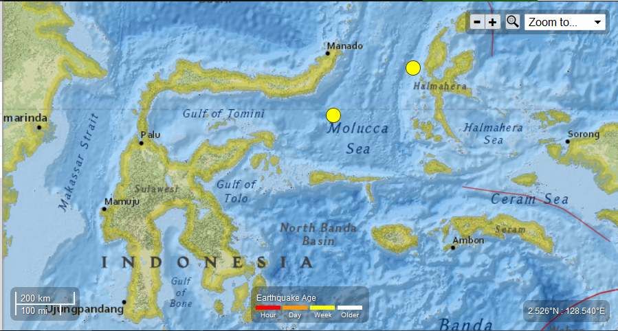
Indonesia - 2 - 5.7 Magnitude Earthquakes June 26th and 27th , 2013

Earth Watch Report  -  Earthquakes


 photo Indonesia-2-57MagEQsJune26thsnd27th2013_zps39f0c85e.jpg
....

M5.7 - 116km SE of Lolayan, Indonesia

 2013-06-26 22:59:04 UTC

Earthquake location 0.154°S, 124.995°E

Event Time

  1. 2013-06-26 22:59:04 UTC
  2. 2013-06-27 06:59:04 UTC+08:00 at epicenter
  3. 2013-06-26 17:59:04 UTC-05:00 system time

Location

0.154°S 124.995°E depth=57.5km (35.7mi)

Nearby Cities

  1. 116km (72mi) SE of Lolayan, Indonesia
  2. 161km (100mi) S of Tondano, Indonesia
  3. 165km (103mi) S of Tomohon, Indonesia
  4. 178km (111mi) S of Bitung, Indonesia
  5. 931km (578mi) N of Dili, East Timor
....

Instrumental Intensity

ShakeMap Intensity Image
....

M5.7 - 44km NW of Kota Ternate, Indonesia

 2013-06-27 08:38:09 UTC

Earthquake location 1.095°N, 127.112°E

Event Time

  1. 2013-06-27 08:38:09 UTC
  2. 2013-06-27 16:38:09 UTC+08:00 at epicenter
  3. 2013-06-27 03:38:09 UTC-05:00 system time

Location

1.095°N 127.112°E depth=130.6km (81.1mi)

Nearby Cities

  1. 44km (27mi) NW of Kota Ternate, Indonesia
  2. 45km (28mi) NW of Ternate, Indonesia
  3. 122km (76mi) SW of Tobelo, Indonesia
  4. 218km (135mi) E of Bitung, Indonesia
  5. 1070km (665mi) SW of Koror Town, Palau
....

Instrumental Intensity

ShakeMap Intensity Image
....

Seismotectonics of the New Guinea Region and Vicinity

The Australia-Pacific plate boundary is over 4000 km long on the northern margin, from the Sunda (Java) trench in the west to the Solomon Islands in the east. The eastern section is over 2300 km long, extending west from northeast of the Australian continent and the Coral Sea until it intersects the east coast of Papua New Guinea. The boundary is dominated by the general northward subduction of the Australia plate.
Along the South Solomon trench, the Australia plate converges with the Pacific plate at a rate of approximately 95 mm/yr towards the east-northeast. Seismicity along the trench is dominantly related to subduction tectonics and large earthquakes are common: there have been 13 M7.5+ earthquakes recorded since 1900. On April 1, 2007, a M8.1 interplate megathrust earthquake occurred at the western end of the trench, generating a tsunami and killing at least 40 people. This was the third M8.1 megathrust event associated with this subduction zone in the past century; the other two occurred in 1939 and 1977.
Further east at the New Britain trench, the relative motions of several microplates surrounding the Australia-Pacific boundary, including north-south oriented seafloor spreading in the Woodlark Basin south of the Solomon Islands, maintain the general northward subduction of Australia-affiliated lithosphere beneath Pacific-affiliated lithosphere. Most of the large and great earthquakes east of New Guinea are related to this subduction; such earthquakes are particularly concentrated at the cusp of the trench south of New Ireland. 33 M7.5+ earthquakes have been recorded since 1900, including three shallow thrust fault M8.1 events in 1906, 1919, and 2007.
The western end of the Australia-Pacific plate boundary is perhaps the most complex portion of this boundary, extending 2000 km from Indonesia and the Banda Sea to eastern New Guinea. The boundary is dominantly convergent along an arc-continent collision segment spanning the width of New Guinea, but the regions near the edges of the impinging Australia continental margin also include relatively short segments of extensional, strike-slip and convergent deformation. The dominant convergence is accommodated by shortening and uplift across a 250-350 km-wide band of northern New Guinea, as well as by slow southward-verging subduction of the Pacific plate north of New Guinea at the New Guinea trench. Here, the Australia-Pacific plate relative velocity is approximately 110 mm/yr towards the northeast, leading to the 2-8 mm/yr uplift of the New Guinea Highlands.
Whereas the northern band of deformation is relatively diffuse east of the Indonesia-Papua New Guinea border, in western New Guinea there are at least two small (<100,000 km²) blocks of relatively undeformed lithosphere. The westernmost of these is the Birds Head Peninsula microplate in Indonesia's West Papua province, bounded on the south by the Seram trench. The Seram trench was originally interpreted as an extreme bend in the Sunda subduction zone, but is now thought to represent a southward-verging subduction zone between Birds Head and the Banda Sea.
There have been 22 M7.5+ earthquakes recorded in the New Guinea region since 1900. The dominant earthquake mechanisms are thrust and strike slip, associated with the arc-continent collision and the relative motions between numerous local microplates. The largest earthquake in the region was a M8.2 shallow thrust fault event in the northern Papua province of Indonesia that killed 166 people in 1996.
The western portion of the northern Australia plate boundary extends approximately 4800 km from New Guinea to Sumatra and primarily separates Australia from the Eurasia plate, including the Sunda block. This portion is dominantly convergent and includes subduction at the Sunda (Java) trench, and a young arc-continent collision.
In the east, this boundary extends from the Kai Islands to Sumba along the Timor trough, offset from the Sunda trench by 250 km south of Sumba. Contrary to earlier tectonic models in which this trough was interpreted as a subduction feature continuous with the Sunda subduction zone, it is now thought to represent a subsiding deformational feature related to the collision of the Australia plate continental margin and the volcanic arc of the Eurasia plate, initiating in the last 5-8 Myr. Before collision began, the Sunda subduction zone extended eastward to at least the Kai Islands, evidenced by the presence of a northward-dipping zone of seismicity beneath Timor Leste. A more detailed examination of the seismic zone along it's eastern segment reveals a gap in intermediate depth seismicity under Timor and seismic mechanisms that indicate an eastward propagating tear in the descending slab as the negatively buoyant oceanic lithosphere detaches from positively buoyant continental lithosphere. On the surface, GPS measurements indicate that the region around Timor is currently no longer connected to the Eurasia plate, but instead is moving at nearly the same velocity as the Australia plate, another consequence of collision.
Large earthquakes in eastern Indonesia occur frequently but interplate megathrust events related to subduction are rare; this is likely due to the disconnection of the descending oceanic slab from the continental margin. There have been 9 M7.5+ earthquakes recorded from the Kai Islands to Sumba since 1900. The largest was the great Banda Sea earthquake of 1938 (M8.5) an intermediate depth thrust faulting event that did not cause significant loss of life.


More information on regional seismicity and tectonics
....

Biological Hazard - State of Indiana, Hoosier : A(H3N2)v (Fujian flu, human) . 4 cases of variant influenza A(H3N2)v No Human Vaccine Available


Earth Watch Report  -  Biological Hazards


....
TodayBiological HazardUSAState of Indiana, HoosierDamage level Details
....

Biological Hazard in USA on Friday, 28 June, 2013 at 03:06 (03:06 AM) UTC.

Description
State health officials are encouraging Hoosiers [residents of the state of Indiana] to take steps to protect themselves at county and 4H fairs around the state this summer [2013] following detection of 4 cases of variant influenza A(H3N2)v. All individuals visited the Grant County Agricultural Fair, 16-22 Jun 2013, prior to illness, and at least 2 had contact with swine. Variant influenza A(H3N2)v was identified in Indiana last year, with a total of 138 cases in 2012. The Indiana State Department of Health and the Grant County Health Department continue to investigate these cases. Human infections with (H3N2)v are rare but have most commonly occurred after close proximity to live infected pigs, such as working with them in barns and livestock exhibits at fairs. Influenza viruses are not transmitted by eating pork and pork products. According to the State Board of Animal Health, 13 pigs at the fair tested positive for H3N2. It is not uncommon for pigs to be infected with swine influenza viruses but not show any signs of illness. If ill with influenza they typically recover. "Fairs are a great way to get outdoors, have some fun and learn about agriculture," said State Health Commissioner William VanNess, MD "If you plan to attend a fair this summer, just be sure to wash your hands frequently and avoid taking food into areas where animals are kept." Symptoms of variant influenza A include: fever, cough, sore throat, chills, headache and muscle aches. Diarrhea and nausea may occur in children. Symptoms can begin approximately one to four days after being exposed to the illness and last from two to seven days.
As several county fairs will open in the next few weeks, State health officials are increasing surveillance for influenza-like illness. "We are increasing our surveillance so we can learn more about this virus and because antiviral treatment is most effective if given within 48 hours," said Dr VanNess. "It's important to contact your health care provider if you begin experiencing flu-like symptoms." And if you have visited a fair or been around animals, let your health care provider know. Influenza antiviral drugs can treat infection with (H3N2)v and quick treatment is especially important for people who are at high risk of serious flu complications, including the very young, the elderly, people with chronic health conditions like asthma, diabetes, and heart disease and pregnant women. Visiting animal exhibits is fun and educational, and Hoosiers are reminded to follow some simple safety steps to prevent illness. Wash hands with soap and water before and after petting or touching any animal. Never eat, drink or put anything in your mouth when visiting animal areas, and avoid face-to-face contact with animals. People at high risk for flu complications should avoid close contact with swine in the fair setting particularly.
While influenza is not an uncommon diagnosis in pigs, the State Board of Animal Health encourages swine owners to contact a veterinarian if their animals show signs consistent with flu, including coughing, respiratory illness, off-feed, and fever. Most county fairs have a private veterinary practitioner on call for on-site assistance. Since there is no vaccine available for people to protect against this (H3N2)v virus, the best way to prevent infection with variant influenza is to avoid sources of exposure to the virus. As always good hygiene and other everyday preventive actions are important to take as well. Wash your hands frequently. Cough or sneeze into your sleeve or elbow. Avoid contact with people or animals that are ill. Stay home if you develop influenza symptoms and contact your health care provider. In 2012, the Centers for Disease Control and Prevention (CDC) reported 309 infections with (H3N2)v in the United States. According to the CDC, most of these infections resulted in mild illness, though 16 people were hospitalized and one person died. Most of the people who were hospitalized and the person who died had one or more high risk conditions.
Biohazard name:A(H3N2)v (Fujian flu, human)
Biohazard level:3/4 Hight
Biohazard desc.:Bacteria and viruses that can cause severe to fatal disease in humans, but for which vaccines or other treatments exist, such as anthrax, West Nile virus, Venezuelan equine encephalitis, SARS virus, variola virus (smallpox), tuberculosis, typhus, Rift Valley fever, Rocky Mountain spotted fever, yellow fever, and malaria. Among parasites Plasmodium falciparum, which causes Malaria, and Trypanosoma cruzi, which causes trypanosomiasis, also come under this level.
Symptoms:Symptoms of variant influenza A include: fever, cough, sore throat, chills, headache and muscle aches. Diarrhea and nausea may occur in children. Symptoms can begin approximately one to four days after being exposed to the illness and last from two to seven days.
Status:confirmed
....

Indiana reports four human cases of H3N2v influenza, advises public to protect themselves at fairs this summer

Photo/Agricultural Research Service
........

Human infections with H3N2v are rare but have most commonly occurred after close proximity to live infected pigs, such as working with them in barns and livestock exhibits at fairs. Influenza viruses are not transmitted by eating pork and pork products.
Symptoms of variant influenza A include: fever, cough, sore throat, chills, headache and muscle aches. Diarrhea and nausea may occur in children. Symptoms can begin approximately one to four days after being exposed to the illness and last from two to seven days.
Nationwide last year, 309 cases of H3N2v infection across 12 states were detected, resulting in one fatality. These infections were mostly associated with prolonged exposure to pigs at agricultural fairs, according to the Centers for Disease Control and Prevention.

Read More Here
....