Global Weather Phenomenon-Natural/Technological Disasters-Space Events-Epidemic/Biological Hazards-
Nuclear Events :
News Affiliate of Family Survival Protocol.com
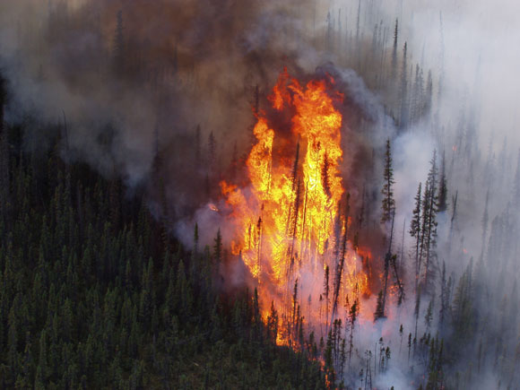
Worst
recorded years for U.S. wildfires are 2005, 2006, 2007, 2011 and 2012.
This year has already joined that list, and wildfire season is still
going strong.
The
2015 wildfire season in the United States has already broken records.
So far this year, more acres of land have burned as of mid-September
than the total annual amount in 2011, which was the 4th worst year for
wildfires at least since the 1960s. So will this year be the new fourth
worst, third worst, second worst, or worst wildfire year since then?
Read on, and take a guess.
The National Interagency Fire Center
in Boise, Idaho, publishes a ton of useful statistics on wildfires that
are critical for helping state and federal agencies manage the flames.
These records date back to the 1960s.
The chart below, created
with the National Interagency Fire Center data, shows that the worst
years for wildfires in the U.S., since these records began being kept,
were 2006 (9,873,745 acres burned), 2007 (9,328,045 acres burned), 2012
(9,326,238 acres burned), 2011 (8,711,367 acres burned), and 2005
(8,689,389 acres burned).
Already as of September 18, 2015,
8,821,040 acres of land have burned across the U.S., and this number
exceeds the total number of acres burned for 2011. Hence, 2015 has
already earned a spot as the 4th worst year on record, and the 2015
wildfire season is still going strong.
A
mosaic of two wide field images taken from the Nevada desert, with the
view stretching from Cepheus to the Milky Way core in Sagittarius.
Credit and copyright: Tanja Sund.
This gorgeous view of the
Milky Way was taken by astrophotographer Tanja Sund during a trip to the
desert in Nevada. Made from just two images, this long exposure (180
seconds) mosaic has incredible detail and stunning clarity. You
seriously need to click on this image to see a larger version!
Most locals reacted like Rick Dinoso when he first heard that all the
fish in the Sparks Marina were dead — an estimated 100,000 trout, bass
and catfish.
"All the fish don't just die," said Dinoso, 37, an assistant manager at a nearby tavern who grew up in Sparks.
"That's a lot of fish," Wayne Weaver said Friday as he walked the 2-mile
loop trail around the 77-acre, man-made lake with wife, Dee. "That's a
lot of recreation lost."
Scientists say the massive fish kill was caused by a dramatic drop in
the water's oxygen content, which they say is not all that uncommon.
They believe it was triggered by a weeklong cold spurt in December when
lows hovered near zero at the former gravel pit converted into a marina
15 years ago along Interstate 80 just east of Reno.
Though testing is incomplete, state wildlife and environmental officials
are convinced there's no danger to humans or animals. There's been no
sign of any contamination like the pollutants that leaked into the pit
in the 1980s from a petroleum tank farm across the highway, they say.
Despite those assurances, city officials have been forced to respond to
concerned citizens. Most worry whether it's safe to let their dogs in
the water.
"It's not good for the fish obviously, but the water quality itself is
great and there's no health or safety issue," city spokesman Adam
Mayberry said. "Other than fishing, there's no indication you can't do
anything else out there that you have always been doing."
Sudeep Chandra, a limnologist at the University of Nevada, Reno known for his research at Lake Tahoe, agrees.
"I really don't think it is other contaminants, it's just the low
oxygen," he said. He said it likely occurred when the oxygen-rich warmer
waters on the lake's surface quickly cooled, sinking to the bottom of
the lake and causing a violent "turnover" of the waters.
A hot, dry summer may have contributed by spurring growth of oxygen-sucking algae, he said.
Mystery of Nevada lake where 100,00 fish died off in a single MONTH
Fish at Sparks Marina near Reno, Nevada, died from lack of oxygen
Biologists can't determine what is causing the loss of oxygen
100,000 trout, bass and catfish washed up dead on the shores of the lake
By
Associated Press Reporter PUBLISHED:
18:56 EST, 16 January 2014
| UPDATED:
19:04 EST, 16 January 2014 State wildlife officials are trying to
figure out why all the fish have died in a northern Nevada marina where
the stocked fishery has flourished since the man-made lake was created
nearly 15 years ago. An
estimated 100,000 trout, bass and catfish have died over the past month
in the Sparks Marina along U.S. Interstate 80 east of Reno, apparently
the result of a dramatic, unexplained drop in dissolved oxygen levels,
Nevada Department of Wildlife spokesman Chris Healy said Wednesday. Scientists
say a bitter cold snap could have caused oxygen-poor waters to rise
from the old rock quarry's bottom to the surface, but they don't
understand what sparked the massive die-off.
+2
All of the fish died in the lake at Sparks Marina in Nevada - 100,000 in a single month
Fish biologists
confirmed low oxygen levels caused the death of an estimated 3,000 fish
in one corner of the lake in mid-December, but Healy said they thought
at the time that the event was localized and of limited impact. Since
then, they've been unable to detect any live fish in the 77-acre lake.
Numerous dead fish have been removed from the lake's shoreline, and
Healy said it's likely the rest sank to the bottom. 'The
100,000 dead fish figure is something that is probably a pretty
conservative guess,' said Healy, who estimates they've stocked close to 1
million adult fish in the lake since they started in 1998.
NV
Energy believes weather may have caused three separate power outages in
different parts of Las Vegas Thursday. An outage knocked out power for
about 885 customers in northwest Las Vegas late Thursday morning. The
utility confirmed the outage in the area of Washington Avenue and Torrey
Pines Drive. Power, though, was restored by mid-afternoon. NV Energy
then reported an outage affecting 79 customers in the area of Third
Street and Colorado Avenue just before 2 p.m. Power was restored to the
downtown area later in the afternoon. Early on Thursday evening, about
1,000 customers lost power in the area of Charleston Boulevard and
Maryland Parkway. Power was restored before 9 p.m.
(Reuters)
- A pneumonia outbreak is threatening hundreds of bighorn sheep in
California's Mojave National Preserve, and wildlife officials said
Monday they see no promising options for saving the state's biggest herd
or protecting a nearby population in Nevada.
The
disease is believed to have killed 20 bighorn sheep during the past
month in the 1.6-million-acre (650,000-hectare) desert preserve, which
lies 50 miles southwest of Las Vegas, National Park Service spokeswoman
Linda Slater said.
"I suspect that many more are
infected," Slater said, adding that the entire herd, numbering as many
as 300 animals, is in danger. "The biologists seem to be very
pessimistic."
Potential options under consideration
include shooting some or all of the remaining members of the herd in a
bid to prevent further spread of the disease, or continuing to monitor
the situation and essentially let nature run its course, wildlife
officials said.
"There really are no good options," Slater said.
Episodic
waves of disease have thinned bighorn herds for years. Fewer than
100,000 sheep are believed to roam the rugged mountain slopes of the
West today, compared with an estimated 1.2 million head that inhabited
the region at one time.
A series of nine separate
outbreaks across five western states, including Nevada, in the winter of
2009-2010 claimed roughly 1,000 bighorn sheep, prized as game animals
for the prominent curled horns of the adult males, or rams. Read More Here
SONNY CLARY/SPECIAL TO THE LAS VEGAS REVIEW-JOURNAL
The
Carpenter Canyon fire forced the mandatory evacuation of Trout Canyon, a
small community of about 21 homes. The fire has now come across the
ridge from the west side of the Spring Mountains, forcing the evacuation
of Kyle Canyon. Officials say Mount Charleston "is closed." ....
05.07.2013
Forest / Wild Fire
USA
State of Nevada, [Mount Charleston, near to Pahrump]
....
Forest / Wild Fire in USA on Friday, 05 July, 2013 at 03:29 (03:29 AM) UTC.
Description
It
is day four of the Carpenter One wildfire on the back side of Mount
Charleston near Pahrump and there is still no containment. A mandatory
evacuation order for the Trout Canyon area was issued on Thursday
afternoon. According to the Bureau of Land Management, 21 homes are
affected. It is not known though if all of those homes are currently
occupied. The latest estimate on the size of the wildfire is 1,250
acres. At one point, the BLM estimated the size at almost 2,000 acres
but lowered that number later. The reason for the mandatory evacuation
because changing weather patterns increased the likelihood of the fire
moving towards the homes. A shelter is being opened at the Hafen
Elementary School in Pahrump and the American Red Cross will be
providing assistance.
....
Mount Charleston 'closed' as growing wildfire threatens homes
JOHN MOWBRAY/SPECIAL TO THE LAS VEGAS REVIEW-JOURNAL
The
Carpenter Canyon fire forced the mandatory evacuation of Trout Canyon, a
small community of about 21 homes. The fire has now come across the
ridge from the west side of the Spring Mountains, forcing the evacuation
of Kyle Canyon. Officials say Mount Charleston "is closed."
JOHN LOCHER/LAS VEGAS REVIEW-JOURNAL
Las
Vegas police block the road to Kyle Canyon on Mount Charleston outside
of Las Vegas on Thursday. A mandatory evacuation has been ordered for
the canyon.
HENRY BREAN/LAS VEGAS REVIEW-JOURNAL
Outside
of Bilbray Elementary School, where a Red Cross shelter was set up for
evacuees, smoke formed an ominous reminder of the advancing fire at
Mount Charleston. A mandatory evacuation of Kyle Canyon sent residents
and holiday picnickers off the mountain. Some ended up at the school
near Fort Apache Road and U.S. 95.
JOHN LOCHER/LAS VEGAS REVIEW-JOURNAL
Chelsea
Catignani cries as she waits to get to her home up Kyle Canyon road on
Mount Charleston outside of Las Vegas Thursday. The road up to Kyle
Canyon had been closed because of fire danger and Catiganani wasn't able
to get to her pets. Smoke from the fire can be seen in the mountains
behind her.
By ROCHEL LEAH GOLDBLATT, COLTON LOCHHEAD, HENRY BREAN and ADAM KEALOHA CAUSEY
LAS VEGAS REVIEW-JOURNAL
Fanned
by increasing winds, a burgeoning wildfire began descending the east
side of Mount Charleston on Thursday, prompting mandatory evacuations
and sending cars full of residents and their possessions down the
mountain.
The building winds made it difficult to fight the blaze
encroaching Kyle Canyon, Las Vegas police spokesman Bill Cassell said.
At 9:45 p.m., the fire was climbing the west side of Cathedral Rock.
The
wildfire kindled by lightning Monday morning in Carpenter Canyon, on
the west side of the Spring Mountains, has grown beyond the 1,250 acres
reported before 1 p.m. Thursday and has crested the peak of Mount
Charleston, officials said.
Multiple sources told the
Review-Journal that the fire was descending the ridge between Griffith
and Mount Charleston peaks. The Bureau of Land Management said late
Thursday no reports of structure damage had been made. Officials did not
update information about the size of the fire or exact location
throughout the night.
Trout Canyon, near the original source of
the fire, also was evacuated, and a shelter was set up in Pahrump for
the residents of the 21 houses there.
Officials began evacuating Lee Canyon, which neighbors Kyle Canyon, late Thursday night.
“They
told me to get off the mountain,” Rose Meranto, a resident of Old Town
in Kyle Canyon said. “They just said don’t waste time and go. So I got
my kitty cats and my son’s cats and I moved.”
About 500 people
were affected by Thursday’s escalating rounds of evacuations. At 11
p.m., Cassell said officers were returning to the homes of those who
were reluctant to leave and requiring them to do so as a matter of
public safety.
“Mount Charleston is closed,” Cassell said.
It’s
not known when evacuees will be allowed to return to their homes. It’s
common in a blaze like this for evacuations to last seven to 14 days,
Cassell said fire officials told him.
State routes 156 and 157 at
U.S. Highway 95 leading to Mount Charleston have been closed, along
with Trout Canyon Road at state Route 160.
No one is being permitted up the mountain.
“The fire reached the trigger point; burning embers are shooting out,” Cassell said.
A
Review-Journal reporter in the Rainbow community on Mount Charleston
witnessed flames twice as tall as the pine trees overlooking Kyle Canyon
before they were obscured by smoke.
Sue Mowbray, a tourist
staying in a Rainbow cabin with her children, said: “The sky was just
bright red. I’ve never seen anything like this before.”
As
Mowbray went down the mountain, she noticed people still at campsites.
She left on her own at 5 p.m., before she was told about the evacuation.


 +2
+2


