
Earth Watch Report - Storms
....
Massive line of storms puts one in five in US at risk for severe weather
Meteorologists from Chicago to Washington warn system could be the 'worst severe weather outbreak' of the year
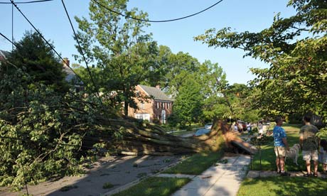
A derecho last June
left millions of people around Washington DC without power for days.
Photograph: Mandel Ngan/AFP/Getty Images
An unusually massive line of storms packing hail, lightning and tree-toppling winds could affect more than one in five Americans on Wednesday as it rolls from Iowa to Maryland.
Meteorologists were even warning about the possibility of a weather event called a derecho, which is a storm of strong straight-line winds spanning at least 240 miles. The storms are also likely to generate tornadoes and cause power outages that will be followed by oppressive heat, said Russell Schneider, director of the National Weather Service's storm prediction center in Norman, Oklahoma.
"We're becoming increasingly concerned that a major severe weather event will unfold," Schneider said. "The main thing is for folks to monitor conditions and have a plan for what to do if threatening weather approaches."
For the first time this year, the center was using its highest alert level for parts of Iowa, Illinois, Indiana and Ohio. The storms will start in the late afternoon in eastern Iowa, Schneider said, and could hit Chicago around rush-hour.
The area the weather service considers to be under heightened risk of dangerous weather includes 74.7 million people in 19 states.
Wednesday "might be the worst severe weather outbreak for this part of the country for the year," said Jeff Masters, meteorology director at Weather Underground.
Read Full Article Here
****************************************************************************
Hail, Lightning & Tree-Toppling Winds: Md. In Line For Massive Storms
June 12, 2013 11:26 PM

Reporting Bob Turk
Meteorologists were even warning about the possibility of a weather event called a derecho, which is a storm of strong straight-line winds spanning at least 240 miles. The storms are also likely to generate tornadoes and cause power outages that will be followed by oppressive heat, said Russell Schneider, director of the National Weather Service’s Storm Prediction Center in Norman, Okla.
“We’re becoming increasingly concerned that a major severe weather event will unfold,” Schneider said. “The main thing is for folks to monitor conditions and have a plan for what to do if threatening weather approaches.”
Bob Turk reports a derecho forming in the Chicago area could possibly make its way to the region Thursday. There are two parts to this storm, Thursday morning and Thursday afternoon into early evening. The first part is primarily rain and the second part could bring us thunderstorms and even possibly tornadoes.
STORM TIMELINE:
- Thursday morning: Rain, varying in intensity and locally heavy in parts. Some thunderstorms are possible
- Thursday afternoon and early evening (2 p.m. until 10 p.m.): Severe thunderstorms are possible with heavy rain, damaging winds and possible tornadoes
- Late Thursday evening (after 10 p.m.): The region will slowly be drying out
Read Full Report Here
***************************************************************************
CBS Chicago
High Risk: Severe Storms Could Bring Tree-Toppling Wind, Tornadoes
June 12, 2013 8:23 AM

UPDATED: 6/12/2013 3:40 p.m.
CHICAGO (CBS) – The National Weather Service was anticipating a major severe weather outbreak in the Chicago area, starting Wednesday afternoon, with the likelihood of very strong storms, large hail, high winds, and a risk of tornadoes.
CBS 2 Meteorologist Megan Glaros reports there is a high risk for severe weather, a rarity for the Chicago area. It’s something more common in Tornado Alley in the central part of the country around Oklahoma and Kansas.
Strong storms in counties west of Chicagoland began to fire up around 3:40 p.m. Storms will continue through as late as 10 p.m. The highest chance of the most severe weather will happen around rush hour and continue into the evening.
In Lee and Ogle counties, a Tornado Warning was issued around 3:50 p.m., and is expected to expire at 4:30 p.m.
A Thunderstorm Warning has been issued for the entire Chicago area until 9 p.m.

Read Full Report Here
***************************************************************************
Related articles
- Mid-West braced for giant 240-MILE line of thunderstorms: One in five Americans told to prepare for devastating derecho k (endtimeheadlines.wordpress.com)
- Unusually Massive Line of Storms Barrel East (washington.cbslocal.com)
- Derecho Weather Pattern Could Mean Severe Weather (pittsburgh.cbslocal.com)
- Massive line of storms pose Ohio threat (newsnet5.com)
- Unusually massive line of storms aim at Midwest (cnsnews.com)
- Massive storm line takes aim at Midwest (wcpo.com)
- What is a derecho? - CBS News (cbsnews.com)
- Unusually massive line of storms aim at Midwest (lacrossetribune.com)
- What's a derecho and why is it heading this way? (pennlive.com)
- Unusually massive line of storms aim at Midwest (khou.com)
No comments:
Post a Comment
Hello and thank you for visiting my blog. Please share your thoughts and leave a comment :)