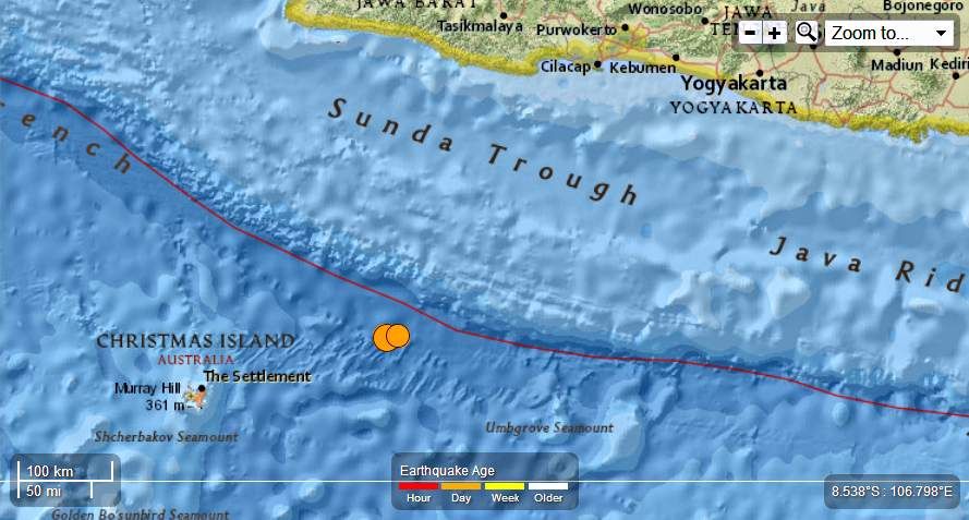
Earth Watch Report - Earthquakes
 ....
....
M6.7 - 176km ENE of Flying Fish Cove, Christmas Island 2013-06-13 16:47:23 UTC
Event Time
- 2013-06-13 16:47:23 UTC
- 2013-06-13 23:47:23 UTC+07:00 at epicenter
- 2013-06-13 11:47:23 UTC-05:00 system time
Location
9.989°S 107.227°E depth=9.7km (6.0mi)Nearby Cities
- 176km (109mi) ENE of Flying Fish Cove, Christmas Island
- 307km (191mi) SSW of Kawalu, Indonesia
- 307km (191mi) SSW of Singaparna, Indonesia
- 309km (192mi) S of Banjar, Indonesia
- 419km (260mi) S of Jakarta, Indonesia
....
M5.4 - 186km ENE of Flying Fish Cove, Christmas Island 2013-06-13 17:23:53 UTC

Event Time
- 2013-06-13 17:23:53 UTC
- 2013-06-14 00:23:53 UTC+07:00 at epicenter
- 2013-06-13 12:23:53 UTC-05:00 system time
Location
9.982°S 107.320°E depth=16.5km (10.2mi)Nearby Cities
- 186km (116mi) ENE of Flying Fish Cove, Christmas Island
- 303km (188mi) SSW of Kawalu, Indonesia
- 303km (188mi) SSW of Singaparna, Indonesia
- 308km (191mi) S of Banjar, Indonesia
- 419km (260mi) S of Jakarta, Indonesia
6.7 magnitude Indonesian earthquake shakes Christmas Island

A magnitude 6.7 quake has shaken Christmas Island overnight.
A SHALLOW 6.7 magnitude earthquake has struck off Indonesia's main island of Java, shaking Christmas Island, more than 400km away.
The quake struck at 11.47pm (local time) (12.47am WST) and was felt by residents on the island.
There are no immediate reports of damage.
According to Geoscience Australia, the quake had a magnitude of 6.7 and was triggered at a depth of 9km.
The US Geological Survey said the quake struck at 11.47pm (local time) at a depth of 11km in Indonesian waters some 170km east of Christmas Island, and 423km south of the Indonesian capital Jakarta.
The quake caused tall buildings in Jakarta to sway slightly.
The Indonesian Meteorology, Climatology and Geophysics Agency said there was no potential for a tsunami.
``There are no immediate reports of damage or casualties, but we know the quake was felt in several parts of Java,'' an agency spokesman said. ``There is no potential for a tsunami.''
The Pacific Tsunami Warning Centre did not issue an alert after the quake.
Indonesia sits on the Pacific ``Ring of Fire'' where continental plates collide, causing frequent seismic and volcanic activity.
Christmas Island is 2600km North West of Perth and about 450km south of Indonesia.It is the main destination for asylum seekers who take the perilous journey from Indonesia to Australia and currently houses hundreds of those waiting for asylum applications to be processed.
....
Related articles
- Very Strong earthquake 165 km from Christmas Island (Australia), harmless for Indonesia (earthquake-report.com)
- Strong quake near Christmas Island (radionz.co.nz)
- Magnitude 6.7 quake strikes off Christmas Island-USGS (dailystar.com.lb)
- 6.7-magnitude quake strikes off Java (rinf.com)
- 6.7 quake strikes off Indonesia's Java: USGS (voicerussia.com)


No comments:
Post a Comment
Hello and thank you for visiting my blog. Please share your thoughts and leave a comment :)