
Earth Watch Report - Earthquakes
....
Published: 6/23 10:38 am
Updated: 6/23 10:40 am
But officials from the Nevada Seismological Laboratory at the University of Nevada, Reno, stress they can't predict how the sequence of over 120 minor quakes that began June 1 will play out or if it will result in larger events.
The largest quakes of the swarm have been one of magnitude-2.9 on June 5 and two of magnitude-2.8 on Thursday and June 16. While each has been followed by many smaller quakes, no injuries or major damage have been reported.
UNR seismologists say based on past seismic activity in the region, the probability of larger quakes increases as sequences progress.
They say the swarm is of concern because it may be associated with the Genoa Fault Zone, which is capable of producing major quakes of magnitude-7 or more.
Nevada is the third most seismically active state in the nation behind California and Alaska.
....
NEVADA REGIONAL EARTHQUAKES IN THE LAST 14 DAYS

....
| ■ | 8.2 mi ENE of Mono_Lake M1.1 |
| ■ | 18.0 mi NE of Eureka_Dunes M1.3 |
| ■ | 15.5 mi NNW of Quincy M1.5 |
| ■ | 14.7 mi NNW of Quincy M1.8 |
| ■ | 16.7 mi NNW of Quincy M1.5 |
| ■ | 20.0 mi ENE of Mammoth_Lakes M1.9 |
| ■ | 2.8 mi ESE of Mammoth_Lakes M1.1 |
| ■ | 11.2 mi NNE of Mammoth_Lakes M2.0 |
| ■ | 17.8 mi NNW of Quincy M2.2 |
| ■ | 4.4 mi SSE of Carson_City M0.5 |
| ■ | 5.5 mi NW of Scottys_Junct. M1.0 |
| ■ | 16.5 mi SSE of Mammoth_Lakes M1.5 |
| ■ | 6.4 mi WNW of Scottys_Junct. M1.0 |
| ■ | 3.7 mi E of Topaz_Lake M1.7 |
| ■ | 3.5 mi E of Topaz_Lake M0.9 |
| ■ | 11.1 mi WNW of Deep_Springs_Valley M1.6 |
| ■ | 4.5 mi NNW of Scottys_Castle M1.2 |
| ■ | 26.7 mi SW of Austin M1.9 |
| ■ | 12.3 mi N of Quincy M1.3 |
| ■ | 6.3 mi W of Bordertown M0.2 |
| ■ | 4.7 mi SE of Carson_City M0.4 |
| ■ | 4.8 mi SE of Carson_City M0.1 |
| ■ | 4.6 mi SE of Carson_City M1.4 |
| ■ | 5.5 mi NE of Scottys_Castle M0.8 |
| ■ | 4.6 mi SSE of Carson_City M0.6 |
| ■ | 4.5 mi SE of Carson_City M1.2 |
| ■ | 4.5 mi SSE of Carson_City M1.0 |
| ■ | 4.5 mi SSE of Carson_City M0.7 |
| ■ | 23.5 mi WSW of Warm_Springs M1.7 |
| ■ | 5.0 mi SSE of Carson_City M0.4 |
| ■ | 19.8 mi NNW of Quincy M2.3 |
| ■ | 40.5 mi N of Tonopah M1.6 |
| ■ | 20.8 mi NW of Gabbs M1.4 |
| ■ | 33.9 mi NE of Warm_Springs M1.6 |
| ■ | 15.5 mi NNW of Quincy M2.9 |
| ■ | 23.0 mi N of Dyer M1.4 |
| ■ | 4.8 mi SE of Carson_City M0.2 |
| ■ | 9.5 mi NE of Gardnerville M0.4 |
| ■ | 10.7 mi NE of Gardnerville M0.5 |
| ■ | 17.1 mi NNW of Quincy M1.6 |
| ■ | 6.0 mi SE of Fernley M1.9 |
| ■ | 8.8 mi NNE of Quincy M1.5 |
| ■ | 7.2 mi SE of Fernley M1.5 |
| ■ | 4.6 mi SE of Carson_City M0.5 |
| ■ | 4.6 mi SE of Carson_City M0.3 |
| ■ | 11.7 mi E of Scottys_Castle M0.8 |
| ■ | 14.0 mi SSE of Topaz_Lake M1.7 |
| ■ | 11.5 mi SE of Scottys_Castle M0.2 |
| ■ | 37.8 mi SE of Warm_Springs M1.6 |
| ■ | 4.5 mi SSE of Carson_City M0.9 |
| ■ | 41.2 mi N of Tonopah M1.8 |
| ■ | 34.1 mi ENE of Trego M1.8 |
| ■ | 10.6 mi ENE of Hawthorne M0.9 |
| ■ | 18.8 mi NNW of Quincy M2.1 |
| ■ | 18.0 mi N of Quincy M1.8 |
| ■ | 14.8 mi SW of Henderson M1.8 |
| ■ | 5.7 mi ENE of Scottys_Castle M1.2 |
| ■ | 4.3 mi SSE of Carson_City M0.0 |
| ■ | 4.6 mi SE of Carson_City M0.6 |
| ■ | 4.7 mi SE of Carson_City M0.1 |
| ■ | 4.4 mi SE of Carson_City M0.1 |
| ■ | 5.5 mi SE of Carson_City M0.1 |
| ■ | 4.6 mi SE of Carson_City M0.7 |
| ■ | 4.6 mi SSE of Carson_City M1.3 |
| ■ | 4.5 mi SSE of Carson_City M0.9 |
| ■ | 4.4 mi SE of Carson_City M1.2 |
| ■ | 4.7 mi SSE of Carson_City M2.8 |
| ■ | 4.4 mi SSE of Carson_City M0.1 |
| ■ | 10.6 mi ENE of Hawthorne M0.8 |
| ■ | 4.5 mi SSE of Mammoth_Lakes M2.2 |
| ■ | 6.2 mi NE of Scottys_Castle M1.2 |
| ■ | 8.3 mi SE of Black_Mountain_Caldera M0.6 |
| ■ | 5.5 mi NW of Sierraville M0.6 |
| ■ | 4.5 mi SSE of Carson_City M0.1 |
| ■ | 10.4 mi ESE of Hawthorne M1.0 |
| ■ | 4.1 mi ENE of Galena_High_School M0.5 |
| ■ | 4.6 mi SSE of Carson_City M1.6 |
| ■ | 8.3 mi SW of Lida_Junct. M0.8 |
| ■ | 21.4 mi E of Dyer M1.0 |
| ■ | 4.6 mi SE of Carson_City M1.5 |
| ■ | 4.0 mi SSE of Carson_City M0.8 |
| ■ | 5.7 mi SE of Carson_City M0.6 |
| ■ | 4.8 mi SE of Carson_City M2.1 |
| ■ | 15.6 mi NNE of Little_Skull_Mountain M0.4 |
| ■ | 11.0 mi WSW of Donner_Lake M0.4 |
| ■ | 2.4 mi SSW of Bordertown M0.3 |
| ■ | 4.9 mi SSE of Carson_City M0.1 |
| ■ | 4.1 mi SSE of Carson_City M0.2 |
| ■ | 3.0 mi SE of Mammoth_Lakes M2.6 |
| ■ | 13.3 mi WSW of Donner_Lake M0.9 |
| ■ | 1.6 mi S of Mammoth_Lakes M3.4 |
| ■ | 1.9 mi S of Mammoth_Lakes M2.4 |
| ■ | 8.6 mi NE of Mammoth_Lakes M1.9 |
| ■ | 3.7 mi W of Mt_Rose M0.4 |
| ■ | 2.3 mi SE of Mammoth_Lakes M2.2 |
| ■ | 16.0 mi NNE of Dyer M1.1 |
| ■ | 0.9 mi E of Mammoth_Lakes M1.7 |
| ■ | 0.9 mi E of Mammoth_Lakes M1.8 |
| ■ | 3.3 mi E of Mammoth_Lakes M1.6 |
| ■ | 3.3 mi E of Mammoth_Lakes M1.9 |
| ■ | 0.9 mi E of Mammoth_Lakes MN/A |
| ■ | 2.4 mi SE of Mammoth_Lakes M2.0 |
| ■ | 20.5 mi ENE of Dyer MN/A |
| ■ | 35.6 mi WSW of Alamo M1.6 |
| ■ | 4.8 mi NNE of Mt_Rose M0.6 |
| ■ | 3.0 mi S of Mina M1.2 |
| ■ | 25.0 mi SSE of Trego M1.8 |
| ■ | 28.4 mi WNW of Pioche M1.8 |
| ■ | 13.5 mi WSW of Donner_Lake M1.8 |
| ■ | 2.8 mi SW of Peavine_Peak M0.8 |
| ■ | 19.5 mi WNW of Alamo M1.1 |
| ■ | 19.2 mi WNW of Alamo M1.1 |
| ■ | 27.1 mi W of Alamo M1.3 |
| ■ | 6.2 mi ENE of Hawthorne M0.0 |
| ■ | 20.6 mi ENE of Little_Skull_Mountain M1.2 |
| ■ | 57.7 mi SW of Topaz_Lake M2.2 |
| ■ | 9.5 mi SSW of Topaz_Lake M0.9 |
| ■ | 4.5 mi SE of Carson_City M0.5 |
| ■ | 4.8 mi SE of Carson_City M0.2 |
| ■ | 4.8 mi SSE of Carson_City M0.8 |
| ■ | 2.1 mi WNW of Double_Springs_Flat M0.9 |
| ■ | 0.7 mi SSE of Mt_Rose M0.6 |
| ■ | 0.7 mi SE of Mt_Rose M0.2 |
| ■ | 4.8 mi SE of Carson_City M0.5 |
| ■ | 4.5 mi SE of Carson_City M0.6 |
| ■ | 13.5 mi ESE of Quincy M0.6 |
| ■ | 26.3 mi N of Eureka M1.8 |
| ■ | 13.4 mi NW of Pyramid_Lake M1.1 |
| ■ | 18.5 mi NNW of Scottys_Castle M0.9 |
| ■ | 4.4 mi SSE of Carson_City M1.4 |
| ■ | 4.5 mi SE of Carson_City M2.0 |
| ■ | 4.8 mi SSE of Carson_City M1.6 |
| ■ | 4.7 mi SSE of Carson_City M1.2 |
| ■ | 7.6 mi SSE of Pioche M1.8 |
| ■ | 4.5 mi SE of Carson_City M0.2 |
| ■ | 4.3 mi SE of Carson_City M0.7 |
| ■ | 4.3 mi SE of Carson_City M0.7 |
| ■ | 4.0 mi SE of Carson_City M0.3 |
| ■ | 4.5 mi SSE of Carson_City M0.8 |
| ■ | 4.5 mi SE of Carson_City M0.1 |
| ■ | 4.5 mi SE of Carson_City M1.4 |
| ■ | 4.6 mi ESE of Pioche M1.8 |
| ■ | 4.6 mi SE of Carson_City M0.2 |
| ■ | 4.7 mi SSE of Carson_City M2.8 |
| ■ | 4.7 mi SSW of Mina M1.2 |
| ■ | 14.5 mi N of Indian_Springs M0.3 |
| ■ | 4.6 mi NW of Scottys_Junct. M1.0 |
| ■ | 32.3 mi ENE of Black_Mountain_Caldera M0.8 |
| ■ | 33.4 mi ENE of Black_Mountain_Caldera M1.0 |
| ■ | 6.1 mi NW of Scottys_Junct. M2.1 |
| ■ | 2.6 mi SE of Little_Skull_Mountain M1.1 |
| ■ | 4.4 mi SE of Carson_City M1.1 |
| ■ | 17.1 mi ESE of Mammoth_Lakes M1.6 |
| ■ | 4.3 mi SE of Carson_City M1.0 |
| ■ | 4.4 mi NW of Scottys_Junct. M1.2 |
| ■ | 4.7 mi SE of Carson_City M0.5 |
| ■ | 36.3 mi NE of Austin M1.9 |
| ■ | 23.2 mi N of Dyer M2.2 |
| ■ | 15.2 mi E of Little_Skull_Mountain M0.5 |
| ■ | 23.0 mi N of Dyer M1.9 |
| ■ | 4.4 mi SE of Carson_City M0.6 |
| ■ | 11.7 mi NE of Yerington M1.0 |
| ■ | 0.4 mi SE of Mt_Rose M0.1 |
| ■ | 4.8 mi SSE of Carson_City M0.5 |
| ■ | 4.3 mi S of Eureka_Dunes M0.5 |
| ■ | 3.9 mi SSE of Eureka_Dunes M0.5 |
| ■ | 6.3 mi NNW of Scottys_Junct. M0.7 |
| ■ | 12.3 mi SE of Schurz M0.3 |
| ■ | 26.2 mi SW of Alamo M0.8 |
| ■ | 2.1 mi N of Mt_Rose M0.2 |
| ■ | 9.5 mi ENE of Hawthorne M0.2 |
| ■ | 6.7 mi NE of Tahoe_City M0.1 |
| ■ | 13.1 mi NW of Pyramid_Lake M1.3 |
| ■ | 8.8 mi NNE of Little_Skull_Mountain M0.1 |
| ■ | 19.0 mi SSW of Mina M0.9 |
| ■ | 8.5 mi NE of Furnace_Creek MN/A |
| ■ | 4.1 mi W of Galena_High_School M0.4 |
| ■ | 15.3 mi SSW of Alamo M1.8 |
| ■ | 3.0 mi NE of Mt_Rose M0.1 |
| ■ | 4.5 mi NNE of Scottys_Junct. M0.8 |
| ■ | 32.7 mi NW of Pyramid_Lake M0.2 |
| ■ | 23.6 mi NW of Pyramid_Lake M0.6 |
| ■ | 23.5 mi WSW of Lovelock M1.8 |
| ■ | 6.2 mi SE of Carson_City M0.2 |
| ■ | 19.5 mi S of Alamo M0.7 |
| ■ | 4.4 mi SE of Carson_City M0.8 |
| ■ | 7.6 mi E of Stovepipe_Wells M1.9 |
| ■ | 19.0 mi NNW of Scottys_Castle MN/A |
| ■ | 17.9 mi NE of Goldfield M1.2 |
| ■ | 17.9 mi NE of Goldfield M0.8 |
| ■ | 18.3 mi NE of Goldfield M1.0 |
| ■ | 12.8 mi NE of Scottys_Junct. M0.7 |
| ■ | 32.9 mi ENE of Black_Mountain_Caldera M0.3 |
| ■ | 5.7 mi WSW of Stampede_Dam M0.4 |
| ■ | 3.8 mi WSW of Bordertown M0.2 |
| ■ | 16.8 mi NE of Deep_Springs_Valley M2.0 |
| ■ | 9.4 mi E of Quincy M0.3 |
| ■ | 14.2 mi WSW of Bishop M2.7 |
| ■ | 9.3 mi N of Scottys_Castle M0.1 |
| ■ | 4.5 mi SE of Carson_City M-0.0 |
| ■ | 4.5 mi SE of Carson_City M1.6 |
| ■ | 9.0 mi SE of Dayton M0.0 |
| ■ | 4.4 mi SE of Carson_City M1.4 |
| ■ | 6.5 mi WNW of Fernley M0.4 |
| ■ | 10.1 mi WSW of Scottys_Castle M0.8 |
| ■ | 4.5 mi SE of Carson_City M0.5 |
| ■ | 4.7 mi SE of Carson_City M1.0 |
| ■ | 1.8 mi W of DRI M0.7 |
| ■ | 1.6 mi WSW of DRI M0.6 |
| ■ | 1.4 mi NNW of UNR_Campus M0.7 |
| ■ | 1.5 mi WSW of DRI M0.5 |
| ■ | 1.6 mi W of DRI M0.2 |
| ■ | 1.8 mi WSW of DRI M0.5 |
| ■ | 3.3 mi ENE of Lathrop_Wells M-0.0 |
| ■ | 4.5 mi W of Topaz_Lake M1.1 |
| ■ | 21.1 mi SSE of Caliente M1.8 |
| ■ | 28.1 mi NNW of Pyramid_Lake M0.4 |
| ■ | 11.9 mi SW of Double_Springs_Flat M1.3 |
| ■ | 17.4 mi NNW of Scottys_Castle M0.5 |
| ■ | 4.5 mi SSE of Carson_City M0.6 |
| ■ | 37.9 mi ENE of Black_Mountain_Caldera M0.5 |
| ■ | 38.9 mi ENE of Black_Mountain_Caldera M0.2 |
| ■ | 38.2 mi ENE of Black_Mountain_Caldera M0.2 |
| ■ | 18.6 mi NE of Eureka_Dunes M0.7 |
| ■ | 16.9 mi NE of Pinnacles_Ridge M1.1 |
Nevada Regional Network
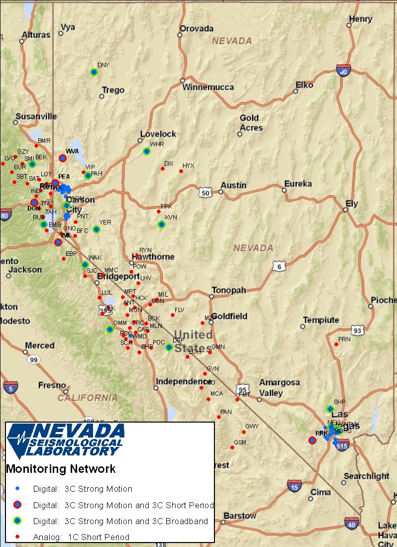
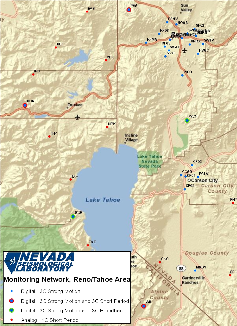
Reno-Tahoe-Carson City Area Monitoring Stations
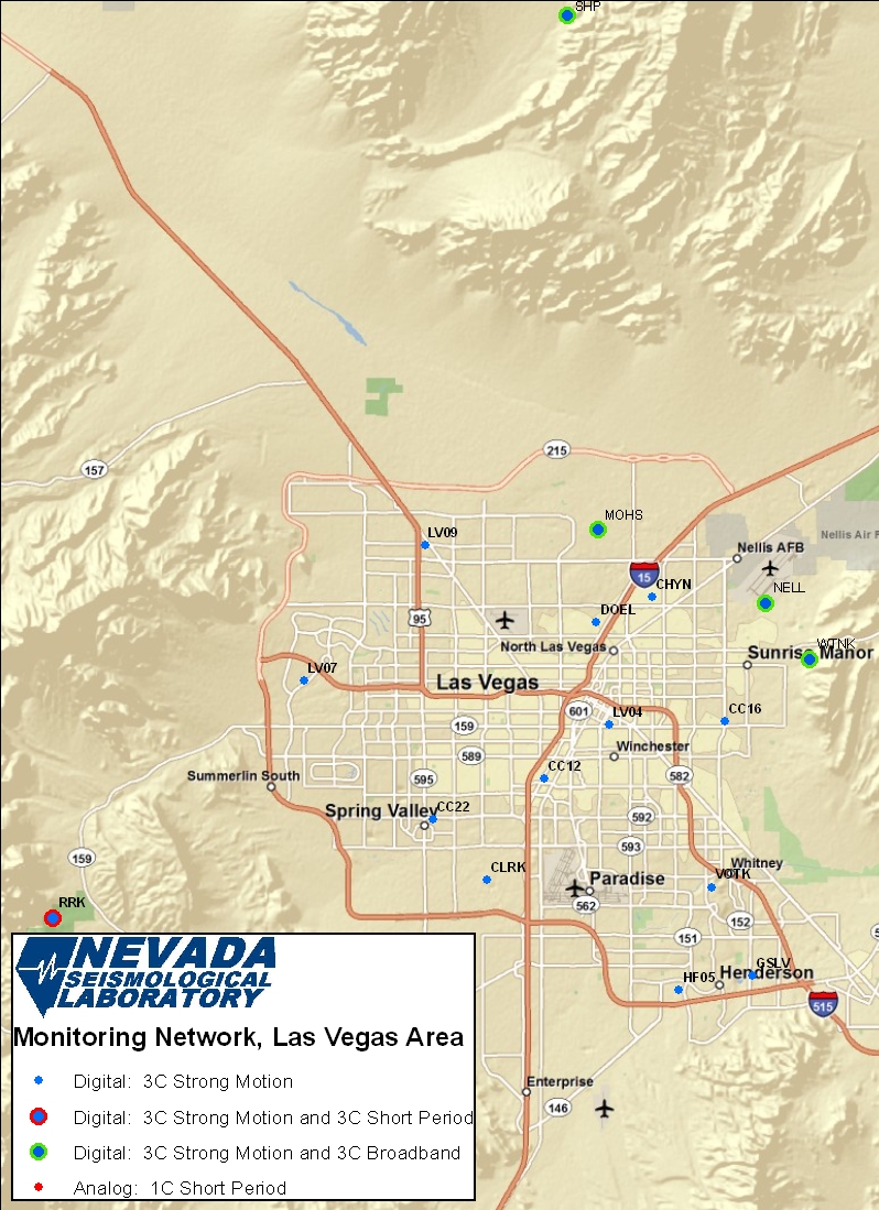
Las Vegas Area Urban Strong Motion and Broadband Stations
Communications and Telemetry Relay Sites Maintained by NSL
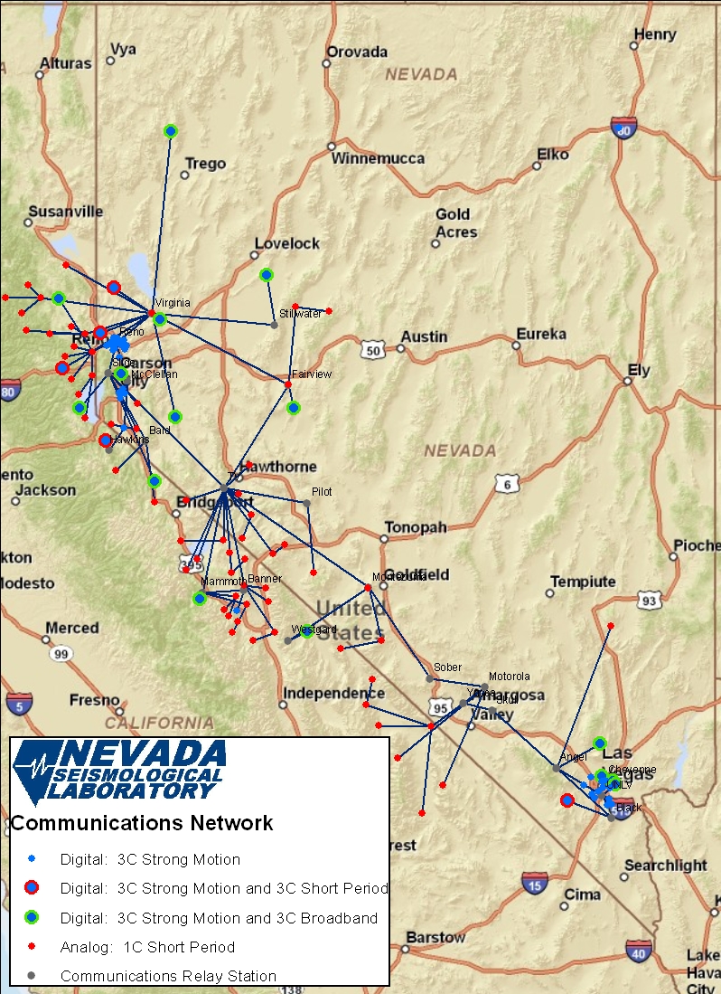
Stations Active in 2008, 2009, and 2010
| NET | STATION | LAT | LON | ELEV(m) | Location | Digitizer | Accelerometer | Sensor | Broadband |
| NN | ADH | 37.97 | -118.72 | 2043 | Adobe Valley, Nevada | UNVCO2 | L-4 | ||
| NN | ANT | 37.92 | -118.56 | 2040 | Antelope Range, California | Tricom | L-4 | ||
| NN | BAB | 39.60 | -120.10 | 2664 | Babbit Peak, California | UNVCO2 | HS-10 | ||
| NN | BCK | 37.70 | -118.37 | 1634 | Birch Creek, California | UNVCO2 | HS-10 | ||
| NN | BEK | 39.87 | -120.36 | 1743 | Beckworth, California | Q330 | 131A-02/3 | CMG-3T | |
| NN | BEN | 37.72 | -118.57 | 2476 | Benton, California | UNVCO2 | L-4 | ||
| NN | BFC | 38.89 | -119.61 | 1743 | Buffalo Canyon, Nevada | UNVCO2 | L-4 | ||
| NN | BHP | 37.30 | -118.49 | 2171 | Bishop, California | UNVCO2 | HS-10 | ||
| NN | BMR | 40.11 | -120.29 | 2146 | Black Mountain, California | UNVCO2 | L-4 | ||
| NN | BON | 37.96 | -118.30 | 2582 | Boundary Peak, Nevada | UNVCO2 | L-4 | ||
| NN | CAS | 37.57 | -118.55 | 2170 | Casa Diablo Mountain, California | UNVCO2 | L-4 | ||
| NN | CC12 | 36.13 | -115.17 | 696 | Clark County Firehouse 12 | 130-ANSS | 131A-02/3 | ||
| NN | CC16 | 36.16 | -115.06 | 551 | Clark Co FS16, 150 N Nellis | 130-ANSS | 131A-02/3 | ||
| NN | CC22 | 36.11 | -115.24 | 643 | Clark Co FS22, 6685 W Flamingo | 130-ANSS | 131A-02/3 | ||
| NN | CCAD | 39.16 | -119.78 | 1460 | Carson City School Admin. | 130-ANSS | 131A-02/3 | ||
| NN | CF01 | 39.16 | -119.76 | 1432 | Carson City Fire Station #1 | Altus | EpiSensor | ||
| NN | CF02 | 39.19 | -119.74 | 1408 | Carson City Fire Station #2 | Altus | EpiSensor | ||
| NN | CF03 | 39.13 | -119.77 | 1341 | Carson City Fire Station #3 | Altus | EpiSensor | ||
| NN | CHYN | 36.22 | -115.11 | 583 | Cheyenne College | Altus | EpiSensor | ||
| NN | CLRK | 36.08 | -115.20 | 705 | Clark Co. Admin Bldg, Russel at Decataur | 130-ANSS | 131A-02/3 | ||
| NN | DIX | 39.80 | -118.08 | 1143 | Dixie Hot Springs, Nevada | UNVCO2 | L-4 | ||
| NN | DNY | 41.09 | -119.28 | 2014 | Donnelly Peak, Nevada | UNDS | 7505/80700 | ||
| NN | DOEL | 36.21 | -115.14 | 578 | DOE Building, Las Vegas | Altus | EpiSensor | ||
| NN | DON | 39.35 | -120.32 | 2268 | Donner Summit, California | 72A-08 | S-13 | ||
| NN | DSP | 37.37 | -117.97 | 1692 | Deep Springs, California | UNDS | CMG-3ESP | ||
| NN | EBP | 38.58 | -119.81 | 2432 | Ebbets Pass, California | UNVCO2 | L-4 | ||
| NN | EGLV | 39.16 | -119.72 | 1435 | Eagle Valley School, CC | 130-ANSS | 131A-02/3 | ||
| NN | EMB | 38.97 | -120.10 | 2134 | Emerald Bay, California | UNVCO2 | L-4 | ||
| NN | EUR | 39.75 | -120.71 | 1951 | Eureka, California | Tricom | L-4 | ||
| NN | FLV | 37.81 | -117.91 | 1689 | Fish Lake Valley, Nevada | UNVCO2 | L-4 | ||
| NN | FMT | 36.64 | -116.78 | 1079 | Funeral Mountains, California | Tricom | L-4 | ||
| NN | FPK | 39.22 | -118.15 | 2524 | Fairview Peak, Nevada | UNVCO2 | HS-10 | ||
| NN | GMN | 37.30 | -117.26 | 2169 | Gold Mountain, Nevada | UNVCO2 | L-4 + L-4-H | ||
| NN | GNO | 38.93 | -119.85 | 1646 | Genoa, Nevada | UNVCO2 | L-4 | ||
| NN | GSLV | 36.04 | -115.04 | 604 | USGS Building, Henderson, SE LVV | 130-ANSS | 131A-02/3 | ||
| NN | GVN | 37.00 | -117.34 | 844 | Grapevine Mountains, California | Tricom | L-4 | ||
| NN | GWY | 36.19 | -116.67 | 1556 | Greenwater Valley, California | Tricom | L-4 | ||
| NN | GZY | 39.96 | -120.65 | 1935 | Grizzly, California | Tricom | L-4 | ||
| NN | HCK | 38.08 | -118.59 | 1890 | Huntoon Creek, Nevada | UNVCO2 | L-4 | ||
| NN | HF05 | 36.03 | -115.09 | 639 | Henderson FS#5 | 130-ANSS | 131A-02/3 | ||
| NN | HTC | 37.53 | -118.77 | 3012 | Hilton Creek, California | UNVCO2 | HS-10 | ||
| NN | HVGC | 39.49 | -119.72 | 1372 | Hidden Valley Golf Course | 130-ANSS | 131A-02/3 | ||
| NN | HYX | 39.77 | -117.76 | 1661 | Hoyt Mine, Nevada | UNVCO2 | L-4 | ||
| NN | IND | 39.43 | -120.29 | 2146 | Independence, California | UNVCO2 | L-4 | ||
| NN | KBF | 39.51 | -120.21 | 2079 | Kyburz Flat, California | UNVCO2 | L-4 | ||
| NN | KVN | 39.05 | -118.10 | 1829 | Kaiserville, Nevada | UNDS | 7505/80700 | ||
| NN | LCH | 37.23 | -117.65 | 1414 | Last Chance Range, California | UNC | L-4 | ||
| NN | LHV | 38.25 | -118.50 | 2225 | Little Huntoon Valley, Nevada | UNVCO2 | L-4 | ||
| NN | LOY | 39.66 | -120.24 | 1582 | Loyalton, California | D-6242 | S-13 | ||
| NN | LUL | 38.05 | -119.18 | 2243 | Lundy Lake, California | UNVCO2 | L-4 | ||
| NN | LV04 | 36.16 | -115.13 | 620 | Las Vegas Fire Station #4 | 130-ANSS | 131A-02/3 | ||
| NN | LV07 | 36.18 | -115.31 | 879 | Summerlin Fire Station 7, West LVV | 130-ANSS | 131A-02/3 | ||
| NN | LV09 | 36.25 | -115.24 | 665 | Las Vegas Fire Station #9 | 130-ANSS | 131A-02/3 | ||
| NN | LVO | 39.87 | -120.87 | 1372 | Little Volcano, California | Tricom | L-4 | ||
| NN | MCA | 36.65 | -117.28 | 303 | Marble Canyon, California | Tricom | L-4 | ||
| NN | MCC | 37.92 | -119.02 | 2255 | Mono Craters, California | UNC | HS-10 | ||
| NN | MGN | 37.81 | -118.70 | 2522 | McGee Canyon, California | UNVCO2 | L-4 | ||
| NN | MIL | 38.02 | -118.19 | 2030 | Miller Mountain, Nevada | UNVCO2 | HS-10 | ||
| NN | MLN | 37.59 | -118.34 | 1780 | Milner Canyon, California | UNVCO2 | HS-10 | ||
| NN | MMC | 38.36 | -119.13 | 2548 | Masonic Mountain, California | UNVCO2 | L-4 | ||
| NN | MND1 | 38.91 | -119.73 | 1481 | Minden/Gardnerville Fire Station | 130-ANSS | 131A-02/3 | ||
| NN | MOHS | 36.25 | -115.14 | 623 | Mojave High School | 130-01 | 131A-02/3 | CMG-3ESP | |
| NN | MPK | 39.30 | -120.03 | 2484 | Martis Peak, California | UNVCO2 | L-4 | ||
| NN | MPT | 38.06 | -118.78 | 2180 | Mono Plateau, California | UNVCO2 | L-4 | ||
| NN | MZP | 37.70 | -117.38 | 2395 | Montezuma Peak, Nevada | UNVCO2 | L-4 | ||
| NN | NELL | 36.22 | -115.03 | 553 | Nellis AFB | 130-01 | 131A-02/3 | CMG-3ESP | |
| NN | NMHS | 39.53 | -119.78 | 1380 | Nevada Mental Health Svc. | 130-ANSS | 131A-02/3 | ||
| NN | NOAA | 39.57 | -119.80 | 1490 | National Weather Station | Altus | EpiSensor | ||
| NN | OMM | 37.61 | -119.00 | 2750 | Old Mammoth Mine, California | 72A-08 | FBA-11 | CMG-3ESP | |
| NN | ORC | 37.64 | -118.66 | 2301 | Owens River, California | UNVCO2 | L-4 | ||
| NN | PAH | 39.71 | -119.38 | 1500 | Pah Rah Range, Nevada | 72A-08 | 131A-02/3 | CMG-40T | |
| NN | PAN | 36.39 | -117.10 | 1697 | Panamint Range | Geotech 42.50 | L-4 + L-4-H | ||
| NN | PEA | 39.61 | -119.96 | 2142 | Peavine Mt., Nevada | 72A-08 | S-13 | ||
| NN | PICO | 39.43 | -119.78 | 1381 | Picolo Elementary School | Altus | EpiSensor | ||
| NN | PNT | 39.09 | -119.60 | 2076 | Pine Nut, Nevada | UNVCO2 | L-4 | ||
| NN | POC | 37.36 | -118.28 | 1799 | Poleta Canyon, California | UNVCO2 | L-4 | ||
| NN | POW | 38.41 | -118.63 | 1890 | Powell Mountain, Nevada | UNVCO2 | L-4 | ||
| NN | PRN | 37.41 | -115.05 | 1464 | Pahroc Range, Nevada | UNVCO2 | S-13 + L-4-H | ||
| NN | QSM | 35.97 | -116.87 | 396 | Queen of Sheba Mine, California | Tricom | L-4 | ||
| NN | RCC | 37.49 | -118.72 | 2800 | Rock Creek Canyon, California | UNVCO2 | HS-10 | ||
| NN | RF05 | 39.51 | -119.84 | 1400 | RF05, 1500 Mayberry | Altus | EpiSensor | ||
| NN | RF08 | 39.54 | -119.86 | 1472 | RF08, 3600 Kings Row | Altus | EpiSensor | ||
| NN | RFMA | 39.52 | -119.90 | 1518 | RF11, 7105 Mae Anne | Altus | EpiSensor | ||
| NN | RFNV | 39.57 | -119.83 | 1544 | RF10, 5250 N. Virginia | Altus | EpiSensor | ||
| NN | RRK | 36.07 | -115.47 | 1209 | Red Rock Park, Nevada | 130-01 | 131A-02/3 | S-13 | |
| NN | RUB | 39.05 | -120.15 | 2045 | Rubicon Trail, California | 72A-08 | S-13 | ||
| NN | RYN | 38.63 | -118.52 | 1585 | Ryan, Nevada | UNVCO2 | L-4 | ||
| NN | SAT | 39.60 | -120.45 | 1972 | Sattley, California | Tricom | L-4 | ||
| NN | SBT | 39.63 | -120.67 | 2152 | Sierra Buttes, California | Tricom | L-4 | ||
| NN | SCH | 37.37 | -118.69 | 2365 | Scheelite, California | UNVCO2 | L-4 | ||
| NN | SF02 | 39.56 | -119.73 | 1380 | SF02, 2900 N Truckee Lane | Altus | EpiSensor | ||
| NN | SHP | 36.51 | -115.16 | 1590 | Sheep Range, Nevada | Q330S | S-13 | ||
| NN | SJC | 38.35 | -119.44 | 2256 | Sonora Junction, California | UNVCO2 | L-4 | ||
| NN | SKYF | 39.48 | -119.83 | 1552 | RF07, 3050 Skyline Blvd. | Altus | EpiSensor | ||
| NN | SLK | 37.83 | -119.13 | 2316 | Silver Lake, California | UNVCO2 | L-4 | ||
| NN | SMI | 39.87 | -120.53 | 2344 | Smith Peak, California | Tricom | L-4 | ||
| NN | SMRN | 39.54 | -119.73 | 1369 | Spark Marina | 130-ANSS | 131A-02/3 | ||
| NN | SPHI | 39.54 | -119.76 | 1359 | Sparks High School | 130-ANSS | 131A-02/3 | ||
| NN | SWTP | 39.52 | -119.70 | 1385 | Sparks Treatment Plant | 130-ANSS | 131A-02/3 | ||
| NN | TAH | 39.15 | -120.16 | 2079 | Tahoe, California | UNVCO2 | L-4 | ||
| NN | TMO | 36.80 | -117.40 | 2170 | Tin Mountain, California | Tricom | L-4 | ||
| NN | TNK | 39.27 | -120.24 | 2438 | Tinkers Knob, California | UNVCO2 | L-4 | ||
| NN | TNP | 38.08 | -117.22 | 1939 | Tonopah, Nevada | UNVCO2 | Benioff | ||
| NN | UNRN | 39.53 | -119.82 | 1390 | Nelson Bldg, Downtown Reno | 130-ANSS | 131A-02/3 | ||
| NN | UNRX | 39.51 | -119.75 | 1318 | University Extension, Mill | Altus | EpiSensor | ||
| NN | VIP | 39.75 | -119.46 | 2499 | Virginia Peak, Nevada | UNVCO2 | HS-10 | ||
| NN | VOTK | 36.08 | -115.07 | 582 | Vocational High School | 130-ANSS | 131A-02/3 | ||
| NN | VPK | 39.47 | -120.04 | 2469 | Verdi Peak, California | UNVCO2 | L-4 | ||
| NN | WAK | 38.50 | -119.44 | 1890 | Walker, California | 72A-08 | S-13 | ||
| NN | WCK | 37.53 | -118.65 | 2500 | Witcher Creek, California | UNDS | 7505/80700 | ||
| NN | WCN | 39.30 | -119.76 | 1704 | Washoe City, Nevada | 72A-08 | 131A-02/3 | CMG-3T | |
| NN | WGLF | 39.50 | -119.82 | 1413 | Washoe County Golf | 130-ANSS | 131A-02/3 | ||
| NN | WHR | 40.04 | -118.36 | 1600 | West Humbolt Range, Nevada | UNDS | 7505/80700 | ||
| NN | WIL | 38.81 | -119.91 | 2470 | S. Lake Tahoe, California | 130-01 | S-13 | ||
| NN | WMD | 37.44 | -118.64 | 1683 | Wells Meadows, California | UNVCO2 | HS-10 | ||
| NN | WNFS | 41.11 | -114.97 | 1723 | USGS USFS office, Humbolt Ave; west side of Wells | 130-ANSS | 131A-02/3 | ||
| NN | WTNK | 36.19 | -115.01 | 697 | 7433 Soaring Heights | 130-01 | 131A-02/3 | CMG-3ESP | |
| NN | WVA | 39.94 | -119.82 | 1670 | Winnemucca Valley, Nevada | 72A-08 | 131A-02/3 | S-13 | |
| NN | YER | 38.98 | -119.24 | 1844 | Yerington, Nevada | 72A-0 |
....
No comments:
Post a Comment
Hello and thank you for visiting my blog. Please share your thoughts and leave a comment :)