
Earth Watch Report - Earthquakes

6 earthquakes in map area USGS
M 3.1 - 14km WNW of Progreso, Mexico
2014-04-18 12:44:32 UTC-05:00 9.7 km
M 2.9 - 13km WNW of Progreso, Mexico
2014-04-18 12:32:10 UTC-05:00 9.8 km
M 4.3 - 94km SW of Tecpan de Galeana, Mexico
2014-04-18 12:01:02 UTC-05:00 19.9 km
M 7.2 - 36km NNW of Tecpan de Galeana, Mexico
2014-04-18 09:27:26 UTC-05:00 24.0 km
M 3.7 - 51km NNE of Camalu, Mexico
2014-04-18 02:39:29 UTC-05:00 10.0 km
M 3.0 - 33km ENE of Maneadero, Mexico
2014-04-18 02:11:33 UTC-05:00 10.0 km
.....
M 7.2 - 36km NNW of Tecpan de Galeana, Mexico
2014-04-18 09:27:26 UTC-05:00 24.0 km
M 7.2 - 36km NNW of Tecpan de Galeana, Mexico
2014-04-18 09:27:26 UTC-05:00 24.0 km

Event Time
- 2014-04-18 14:27:26 UTC
- 2014-04-18 09:27:26 UTC-05:00 at epicenter
- 2014-04-18 09:27:26 UTC-05:00 system time
Location
17.552°N 100.816°W depth=24.0km (14.9mi)Nearby Cities
- 36km (22mi) NNW of Tecpan de Galeana, Mexico
- 48km (30mi) E of Petatlan, Mexico
- 56km (35mi) NW of Atoyac de Alvarez, Mexico
- 78km (48mi) E of Zihuatanejo, Mexico
- 273km (170mi) SW of Mexico City, Mexico
Tectonic Summary
The April 18, 2014 M 7.2
earthquake near the western coast of Mexico occurred in the state of
Guerrero, 265 km southwest of Mexico City. The earthquake occurred as
the result of thrust motion at shallow depths. The initial location,
depth, and mechanism of the April 18 earthquake are broadly consistent
with slip on or near the plate boundary interface between the subducting
Cocos oceanic sea plate and the North America plate.
The broad scale tectonics of the west coast of Mexico are controlled by the northeastward subduction of the Cocos plate beneath the North America plate at a rate of approximately 65 mm/yr. Earthquakes are a common occurrence along the Middle American subduction zone; the April 2014 earthquake occurred just northwest of the rupture area of the 1957 M 7.8 Guerrero Earthquake. Since 1975, 23 events of M > 6.0 have occurred within 200 km of the April 2014 earthquake, including events of M 8.0 and M 7.6 (September 1985), M 7.2 (October 1981), and M 7.5 (March 1979), all to the northwest. The 1981 and 1979 events caused 9 and 5 shaking-related fatalities, respectively. The 1985 M 8.0 earthquake, 195 km to the northwest of the April 2014 event, led to more than 9,500 fatalities, mostly in Mexico City, and generated small, local tsunamis. That event was influential in initiating efforts to establish earthquake early warning systems in Mexico City.
The April 2014 earthquake occurred within the “Guerrero Seismic Gap” – an approximately 200 km long segment of the Cocos-North America plate boundary identified to have experienced no significant earthquakes since 1911 (M 7.6). The plate interface in this region is known to be locked, with an earthquake of M 8.1-8.4 thought possible should the entire gap rupture in a single event.
.....
Contributed by USGS National Earthquake Information Center
Instrumental Intensity

.....
Magnitude-7.2 Earthquake Shakes Mexican Capital
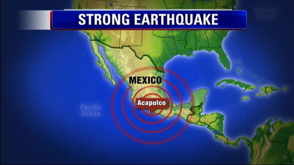

A powerful magnitude-7.2 earthquake shook central and southern Mexico on Friday, sending panicked people into the streets. Some walls cracked and fell, but there were no reports of major damage or casualties.
The U.S. Geological Survey said the quake at about 9:30 a.m. (10:30 a.m. EDT; 1430 GMT) was centered on a long-dormant fault line northwest of the Pacific resort of Acapulco, where many Mexicans are vacationing for the Easter holiday.
It was felt across at least a half-dozen states and Mexico's capital, where it collapsed several walls and left large cracks in some facades. Debris covered sidewalks around the city.
Around the region, there were reports of isolated and minor damage, such as fallen fences, trees and broken windows. Chilpancingo, capital of the southern state of Guerrero, where the quake was centered, reported a power outage, but service was restored after 15 minutes.
In Acapulco, 59-year-old Enedina Ramirez Perez was having breakfast, enjoying the holiday with about 20 family members, when her hotel started to shake.
"People were turning over chairs in their desperation to get out, grabbing children, trampling people," the Mexico City woman said. "The hotel security was excellent and started calming people down. They got everyone to leave quietly."
The quake struck 170 miles (273 kilometers) southwest of Mexico City, where people fled high-rises and took to the streets, many in still in their bathrobes and pajamas on their day off.
"I started to hear the walls creak and I said, 'Let's go,'" said Rodolfo Duarte, 32, who fled his third-floor apartment.
Mexico City Mayor Miguel Angel Mancera said there were small power outages from fallen transformers but officials were working to restore the service.
The USGS initially calculated the quake's magnitude at 7.5, but later downgraded it to 7.2. It said the quake was centered 22 miles (36 kilometers) northwest of the town of Tecpan de Galeana, and was 15 miles (24 kilometers) deep.
Read More Here
.....
Related articles


No comments:
Post a Comment
Hello and thank you for visiting my blog. Please share your thoughts and leave a comment :)